Download presentation
Presentation is loading. Please wait.

1
Geocoding Chapter 16 GISV431 &GEN405 Dr W Britz

2
Georeferencing, Transformations and Geocoding Georeferencing is the aligning of geographic data to a known coordinate system so it can be viewed, queried, and analyzed with other geographic data. Georeferencing may involve shifting, rotating, scaling, skewing,and in some cases warping, rubber sheeting, or orthorectifying the data. (It has to do with real world coordinates) Transformations are used when Georeferencing
 Transformations are used when Georeferencing.")
3
Transformation The process of converting the coordinates of a map or an image from one system to another, typically by shifting, rotating, scaling, skewing, or projecting them. transformation Illustration [data conversion]

4
Geocoding A GIS operation for converting street addresses into spatial data that can be displayed as features on a map, usually by referencing address information from a street segment data layer.

5
5 What does Chang say about Geocoding? Geocoding refers to the process of assigning spatial locations to data that are in tabular format but have fields that describe their locations. Address geocoding is the most common type of geocoding, which plots street addresses as point features on a map. Address geocoding requires two sets of data. The first data set contains individual street addresses in a table, one record per address. The second is a reference database that consists of a street map and attributes for each street segment such as the street name, address ranges, and ZIP/postal codes. Address geocoding interpolates the location of a street address by comparing it with data in the reference database.

6
6 A sample address table records name, address, and ZIP code.

7
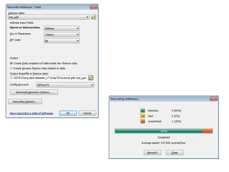
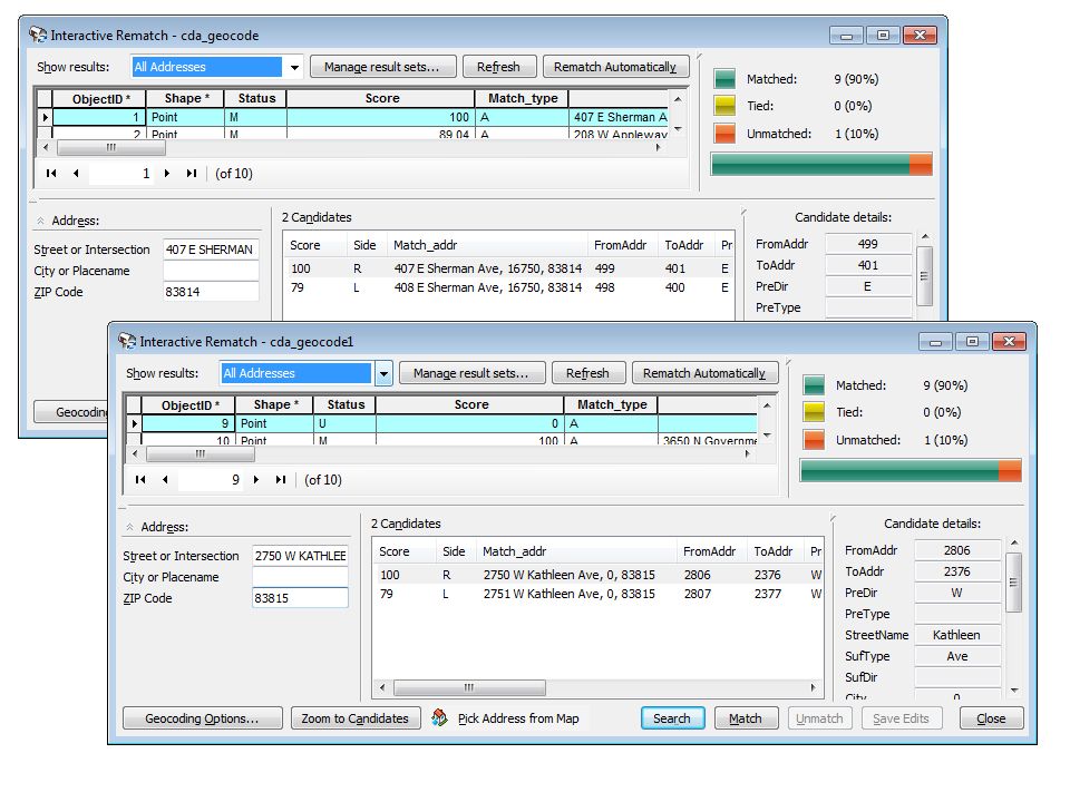
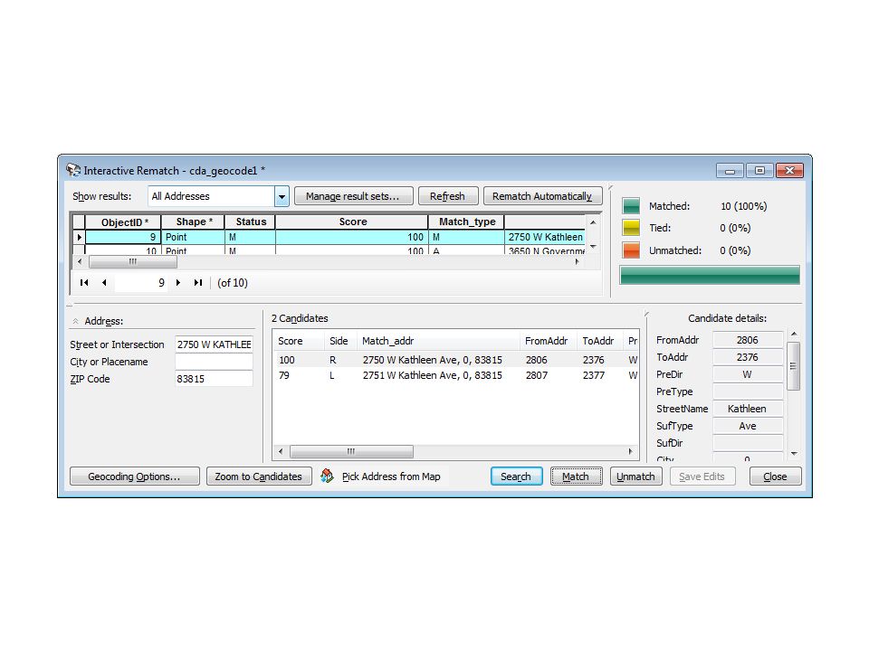
7 The Geocoding Process The geocoding process consists of two phases: preprocessing and matching. The preprocessing phase involves parsing and address standardization. The next phase matches an address against a reference database and plots the address as a point feature.

8
8 Address Matching Options Typically, a geocoding engine has provisions for relaxing the matching conditions but uses a scoring system to quantify the matches at the same time. Because of the various matching options, we can expect to run the geocoding process more than once. GIS packages have the side offset and end offset options for plotting geocoded points.

9
9 The end offset moves a geocoded point away from the end point of a street segment, and the side offset places a geocoded point away from the side of a street segment.

10
10 Other Types of Geocoding Intersection matching matches address data with street intersections on a map. ZIP code geocoding refers to the process of matching a ZIP code to its centroid location. Reverse geocoding is a process of converting latitude and longitude coordinate data of locations into descriptive addresses.

11
11 An example of Intersection matching.

12
12 Applications of Geocoding 1.Location-based services 2.Business applications 3.Wireless emergency services 4.Crime mapping and analysis 5.Public health

13
Let’s focus on Address Matching Geocoding Two inputs: – 1) a DBF or text table with the address records to be geocoded and – 2)a geographic reference layer, like streets Output: a point file, where each point represents an address record
 a DBF or text table with the address records to be geocoded and – 2)a geographic reference layer, like streets Output: a point file, where each point represents an address record")
14
How are addresses matched? Common method: matching address to street ranges. Urban areas: usually each street segment (arc) corresponds to a block. Each segment has attributes for the left from and to and right from and to addresses. Hence computer knows the left address and right address and the beginning and end of the block. (topology) Computer matches street name, address range Interpolates the position of the address point on segment
 corresponds to a block. Each segment has attributes for the left from and to and right from and to addresses. Hence computer knows the left address and right address and the beginning and end of the block. (topology) Computer matches street name, address range Interpolates the position of the address point on segment.")
15
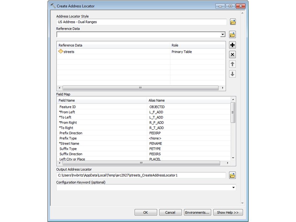
Address Matching in ArcGIS First create a address locator Defines reference layer Also where you specify information about your reference layer that ArcGIS might not know, allowing for more efficient geocoding

16
Geocoding in Arc GIS We create our address locator in Arc Catalog. This will bring up a dialogue asking for the geocoding style for that geocoding service

22
Geocoding and Error Your Geocoding result is only as good as your reference data. If your streets layer is accurate only to 200 meters of accuracy, so will your geocoded points be. If your streets are consistently 100 meters to the north, then your points will be the same too Some roads layers may have better attributes than other too.

23
©2007 Austin Troy Geocoding and Error Here’s an example where the same address list was geocoded with two different street layers. Note here how the same house is 100 m off between the two geocoding attempts 100 m

24
©2007 Austin Troy Geocoding and Error Here we see that many points were coded for Napa1 that were not coded for Napa2 possibly because Napa1’s street reference layer is newer, and has more streets

25
Geocoding and Error This error is due to an attribute error in one of the layers which puts that address in the wrong street segment 100 m 300 m

26
©2007 Austin Troy Geocoding and Error A rural area with a long road segment: very imprecise An urban road segment: smaller, more precise Rural street segments are also more subject to more error because street segments longer, so relies more on interpolation

27
XY Geocoding We can also create points from a table by their latitude and longitude Do this by clicking: CA haz. waste sites Then we specify the lat and long fields as well as the spatial reference system Lat and Long should be in decimal degrees

28
I am an analyst working in an insurance company, please just show me how to geocode my addresses.

29
Geocoding addresses IIS Geocode

30
Ways to do Geocoding Batch Interactive Reverse

31
Demo Geocoding with ArcGIS Online

32
Geocoding with ArcGIS.com ArcGIS Online Geocoding – An Introduction

33
Geocoding with World service ArcMap

34
Geocoding Toolbar Manage Address Locators (List of default locators) Address Inspector Geocode Addresses Review/ Rematch Address Input box (Find address in a single-line format) A quick way to geocode address Use map extent
 Address Inspector Geocode Addresses Review/ Rematch Address Input box (Find address in a single-line format) A quick way to geocode address Use map extent")
35
Find Tool Choose locator Specify address Show all candidates Use Map Extent My Places

36
I am a GIS specialist working in the county government, please show me how to use my data to create address locators or services.

37
Workflow of geocoding Create locator / service IIS Geocode

38
Geocoding with a locator Determine address locator style Build an address locator Locate addresses Build or obtain reference data

39
Reference Data Many sources StreetMap data Government data Data vendors Data shared on ArcGIS.com

40
Geocoding Work Flow Build an address locator Locate addresses Build or obtain reference data Determine address locator style

41
What is an Address Locator Style Template containing geocoding properties Choose style based on properties of: Address data: address information to geocode Reference data: geometry and attribute values Locator styles can be customized to support international addresses

42
Locator Style Example US Address - Single House Reference Data = Points or Polygons US Address - Single House Reference Data = Points or Polygons

43
Geocoding Work Flow Locate addresses Build or obtain reference data Determine address locator style Build an address locator

44
Building an address locator Specify Output Address Locator Specify reference data Select an address locator style Open the Create New Address Locator tool Examine address and reference data

45
Demo Create an address locator Geocode addresses

46
Geocoding Work Flow Build or obtain reference data Determine address locator style Build an address locator Locate addresses

47
Composite Locator Combines multiple locators Geocode against multiple datasets Cascade/Fallback geocoding Spatially disjointed datasets

48
Demo Create a composite locator

49
Publishing locator as a geocode service

50
Recap Create locator / service IIS Geocode

51
Summary – Geocoding with ArcGIS 10.2 What is geocoding? Geocoding work flow Geocoding – An Introduction Geocoded features Table of Addresses Address Locator Geocode services

52
Resources and References Esri Resource Centers http://resources.arcgis.com/en/communities/geocoding

Similar presentations