Download presentation
Presentation is loading. Please wait.

1
OpenGIS2006@Sinica The Overview of GeoSemantic Web Service 榮峻德 台大地理所博士班學生 2006.12.08

2
OpenGIS2006@Sinica TOCs 1.1 Motivations 1. INTRODUCTION 1.2 Objectives 2.1 The semantic web 2. BACKGROUND AND RELATED WORKS 2.2 Ontology Nowadays / Data Warehouse 3. THE FRAMEWORK OF GEOSEMANTIC WEB SERVICE SDI / Web Services 2.3 Discover GIServices in SDI Semantic Web Services

3
OpenGIS2006@Sinica 1. INTRODUCTION

4
OpenGIS2006@Sinica Motivation NCGIAUCGISInteroperability Cognitive Models of Geographic Space Computational Implementations of Geographic Concepts Geographies of the Information Society OGC 10 Challenges Cognition of Geo_ graphic Information Interoperability of Geographic Information The Future of the Spatial Information Infrastructure Three problems: Syntactic Structure Semantic GIServices: WFS WMS WCS WPS CS Cognition 、 Interoperability 、 GIServices

5
OpenGIS2006@Sinica Motivation

6
OpenGIS2006@Sinica Introduction 整合 GIS 資訊的年代 Interoperability Problem –Syntactic Data type, data format…etc. –Structure Projection, datum –Semantic Naming differences: same name but different concept. Concept differences: same concept but different names.

7
OpenGIS2006@Sinica Introduction Applied Ontology into the architecture of SDI Build a GeoSemantic Web (service) Apply a Domain knowledge to prove the concept!
 Apply a Domain knowledge to prove the concept!")
8
OpenGIS2006@Sinica 2. RELATED WORKS

9
OpenGIS2006@Sinica Related Works Semantic Web –Semantic problems –What is semantic web? –Components of semantic web –Geospatial semantic web Ontologies –Ontology –The architecture of ontologies –Ontology languages –Geospatial ontologies Discover GIService on SDI –SDI (Spatial Data Infrastructure) –Web services –GIServices –Discover GIServices on SDI Domain Knowledge Reviews Semantic Web OntologySDI GIServices Domain Knowledge
 –Web services –GIServices –Discover GIServices on SDI Domain Knowledge Reviews Semantic Web OntologySDI GIServices Domain Knowledge.")
10
OpenGIS2006@Sinica 2.1. Semantic Web

11
OpenGIS2006@Sinica 譬如:「台大裡的醉月湖」 Semantic Problems

12
OpenGIS2006@Sinica Semantic Problems

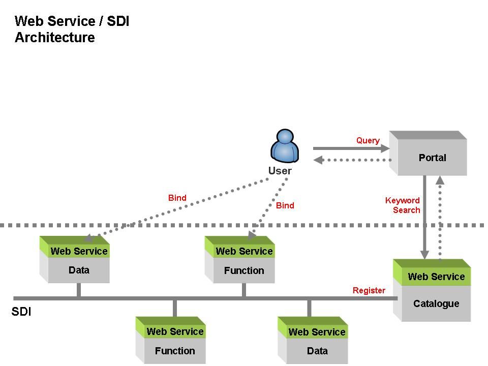
13
OpenGIS2006@Sinica Concept 2 “mont” “montaña” “mountain” “berg” Concept 1 “ ” Concept 3 Concept 4 Concept 5 Words in different languages Real world Mark, David ( 2005 ) Semantic Problems
 Semantic Problems")
14
OpenGIS2006@Sinica Semantic Problems Brodeur et al., 2003

15
OpenGIS2006@Sinica Semantic Problems Naming Heterogeneity: –Two data with the same data type and refer to the same domain concept, but have different names. Data Type Heterogeneity: –Two data with the same name and refer to the same domain concept, but represented with different data types. Conceptual Heterogeneity: –Two data with the same name and data type, but refer to different domain concepts.

16
OpenGIS2006@Sinica Semantic Web What is Semantic Web ? –an extended web of machine-readable information and automated services that amplify the Web far beyond current capabilities

17
OpenGIS2006@Sinica Semantic Web Components of Semantic Web

18
OpenGIS2006@Sinica GeoSemantic Web UCGIS considered that the geospatial semantic web would be one of critical research priorities for geographic information science (Fonseca, 2002). The Geospatial Semantic Web is to capture, analyze and tailor geospatial information, much beyond the purely lexical and syntactic level which needs (Egenhofer, 2002): –Geospatial Ontology –Representation –match OGC (Open Geospatial Consortium): –GML (Geography Markup Language): xml-based –WFS (Web Feature Services), WMS (Web Map Services)…
: –Geospatial Ontology –Representation –match OGC (Open Geospatial Consortium): –GML (Geography Markup Language): xml-based –WFS (Web Feature Services), WMS (Web Map Services)….")
19
OpenGIS2006@Sinica 2.2. Ontologies

20
OpenGIS2006@Sinica Ontologies Ontology –Philosophy: the nature and the organization of reality. –Information Science: an explicit specification of a conceptualization. –Classes –relations

21
OpenGIS2006@Sinica Ontologies http://lsdis.cs.uga.edu/~farshad/events/EventSchema.png

22
OpenGIS2006@Sinica Ontologies Ontology languages –Ontology languages allow users to write explicit, formal conceptualizations of domain models which include following main requirements : well-defined syntax formal semantics Convenience of expression and sufficient expressive power Efficient reasoning support –Class membership : if x is an instance of a class C, and C is a subclass of D, then we can infer that x is an instance of D. –Equivalence of classes : if A → B and B → C, then A → C. –Consistency : if x is an instance of class A, and A is a subclass of B ∩ C, A is a subclass of D, and B and D are disjoint. –Classification : if we have declared that certain property-value pairs are a sufficient condition for membership in a class A, then if an individual x satisfies such conditions, we can conclude that x must be an instance of A.

23
OpenGIS2006@Sinica Ontologies Ontology languages –OWL (Web Ontology Language) specified by W3C = DARPA + OIL well-defined syntax formal semantics Convenience of expression and sufficient expressive power Efficient reasoning support OWL Software –Protégé (http://protege.stanford.edu/) –RACER (http://www.sts.tu-harburg.de/~r.f.moeller/racer/)
 specified by W3C = DARPA + OIL well-defined syntax formal semantics Convenience of expression and sufficient expressive power Efficient reasoning support OWL Software –Protégé ( –RACER (")
24
OpenGIS2006@Sinica Ontologies Geospatial Ontologies –Different spatial Cognition → Different spatial concept. Fonseca et al. ( 2002 )
.")
25
OpenGIS2006@Sinica Ontologies Geospatial Ontologies – 認知空間中什麼樣的知識、 classes 、 relations

26
OpenGIS2006@Sinica Ontologies The architecture of Ontologies

27
OpenGIS2006@Sinica 2.3. Discover GIService on SDI

28
OpenGIS2006@Sinica Discover GIServices on SDI SDI –a multi-levelled, scalable, and adaptable collection of technical and human services, which are interconnected across system, organizational, and administrative boundaries via standardized interfaces. GIS for the Nation (2006)
.")
29
OpenGIS2006@Sinica Discover GIServices on SDI Web services –a networked application that is able to interact using standard application-to-application.

30
OpenGIS2006@Sinica Discover GIServices on SDI GIService –network-based geographic information services that utilize both wired and wireless Internet to access geographic information, spatial analytical tools and other GIS resources. –GIS Data Access services & Geo-processing services OGC –WFS (Web Feature Service) –WMS (Web Map Service) –WPS (Web Processing Service) –CS (Catalogue Service)
 –WMS (Web Map Service) –WPS (Web Processing Service) –CS (Catalogue Service).")
31
OpenGIS2006@Sinica Discover GIServices on SDI WMS example http://140.112.64.249/wmsconnector/com.esri.wms.Esrimap?ServiceName=WGS84_M xd_Taipei

32
OpenGIS2006@Sinica Discover GIServices on SDI –In previous literatures, there are two main parts used ontology applied into SDI: Discovering GIServices (Bernald et al., 2003; Bernard, Einspanier, Haubrock et al., 2003; Probst and Lutz, 2004; Klien, Lutz, and Kuhn, 2006; Lemmens, 2006; Lutz, 2006) Using ontology for semantic interoperability composes (Bernard, Einspanier, Lutz et al., 2003; Einspanier et al., 2003; Probst and Lutz, 2004; Lutz, 2006)
 Using ontology for semantic interoperability composes (Bernard, Einspanier, Lutz et al., 2003; Einspanier et al., 2003; Probst and Lutz, 2004; Lutz, 2006)")
33
OpenGIS2006@Sinica Discover GIServices on SDI Lutz, 2006

34
OpenGIS2006@Sinica 2.4. Domain Knowledge

35
OpenGIS2006@Sinica Domain Knowledge Not decided yet. Scenario: Geomorphology – 溶洞(石灰岩洞、鐘乳石洞):雨水或地下水溶解侵蝕石灰岩所形成的洞穴。 –Classes :雨水、地下水、石灰岩、洞穴 –Relationships :溶解侵蝕 地下水 石灰岩 溶解 侵蝕 GML Data GIS Data Index WFS Data WFS Data WFS shp GML Functions Analysis A Analysis B Analysis C
:雨水或地下水溶解侵蝕石灰岩所形成的洞穴。 –Classes :雨水、地下水、石灰岩、洞穴 –Relationships :溶解侵蝕 地下水 石灰岩 溶解 侵蝕 GML Data GIS Data Index WFS Data WFS Data WFS shp GML Functions Analysis A Analysis B Analysis C.")
36
OpenGIS2006@Sinica 3. The framework of GeoSemantic Web Services

40
OpenGIS2006@Sinica Conclusion The GeoSemantic web focuses on geospatial domain to extract explicitly geospatial knowledge that is used multi-level ontologies to manage. GeoSemantic interoperability will be the major research for users to discover GIS data or GIServices more accurate in SDI. In the future, a Geo-domain knowledge would be applied into the architecture of GeoSemantic web to evaluate the efficiency and accuracy.

41
OpenGIS2006@Sinica Contact me : Calvin C. JUNG 榮峻德 d94228001@ntu.edu.tw http://ediyacoo.googlepages.com d94228001@ntu.edu.tw http://ediyacoo.googlepages.com Thank You ~ ! Questions ?

Similar presentations


 Department of Electrical and Computer Engineering>")


