Download presentation
Presentation is loading. Please wait.

1
Modeling of Flows in GIS. Michael F. Goodchild Alan Glennon Department of Geography University of California, Santa Barbara 8 December 2004 Hot Creek, California / photo: Glennon

3
Data modeling issues Mixtures of primitive elements the lower Colorado Linear features with transverse detail the coastal zone, railroads Fields of objects viewsheds, watersheds Interactions over space attributes of pairs of objects association classes

4
Dynamics moving objects tracking vehicles as points objects that change shape imaging vehicles objects with changing internal structure severe storms

5
Peggy Agouris (Maine): Tracking vehicles through feature extraction from imaging camera
: Tracking vehicles through feature extraction from imaging camera")
6
Helix representation Spine: expresses spatio- temporal 3-D movement of the center of mass. Prongs: express expansion or collapse of the object’s outline

7
May Yuan, University of Oklahoma

8
Hurricane Frances

9
Hurricane helixes

11
Flows A common type of data in: hydrology, atmospheric science social science Channeled migration streamflow Unchanneled overland flow ocean currents

12
Outline Purpose Model Development Implementation Future Work slide 2 / 22

13
Purpose Formalize the concept of flow in geographic space. Create a framework to store flow information in GIS. Create tools to access flow information in GIS for visualization and analysis. Broader Context Allow sharing / provide common information format for flows within GIS. The way flow data is organized influences the analyses that can be conducted. Ontology of flow a better understanding / characterization of geographic dynamics. Expand the capabilities of GIS. slide 3 / 22

14
Tobler’s Flow Mapper Program slide 4 / 22

15
www.csiss.org under Spatial Tools

16
Use Cases Spatial Interaction Table: Human Migration Minard’s Map of Napoleon’s March to Moscow Karst Watershed Flow Routes slide 7 / 22 Source: The Napoleon Foundation

17
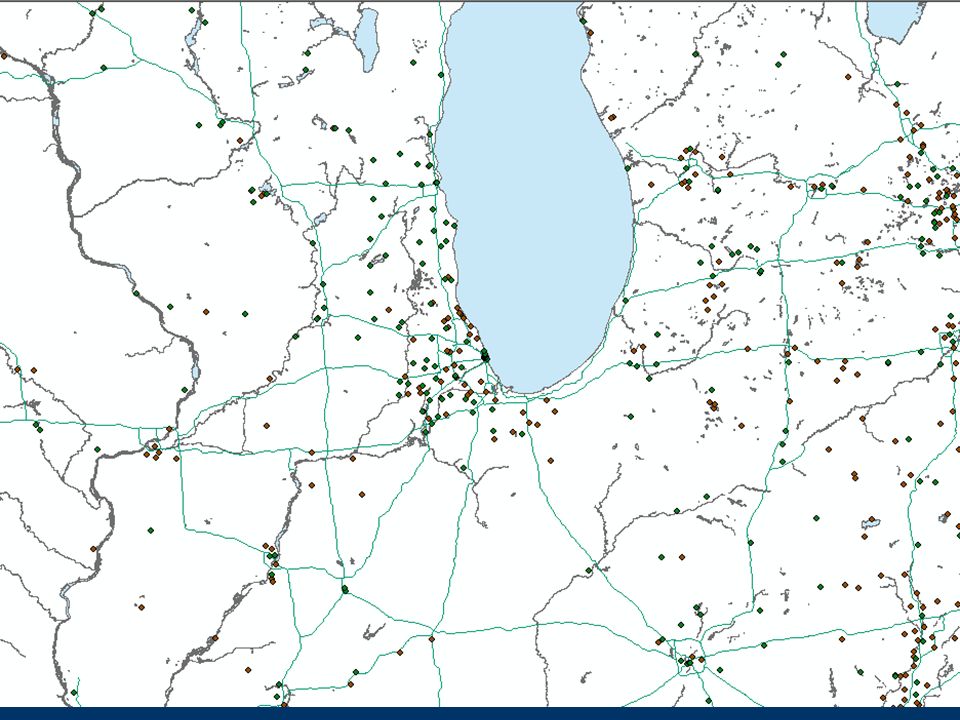
slide 8 / 22 Source: U.S. Census Bureau, Census 2000

18
slide 9 / 22 Source: Tufte, 2001

19
Mill Hole, Kentucky / photo: Jasper Cave Survey Book / photo: Glennon

20
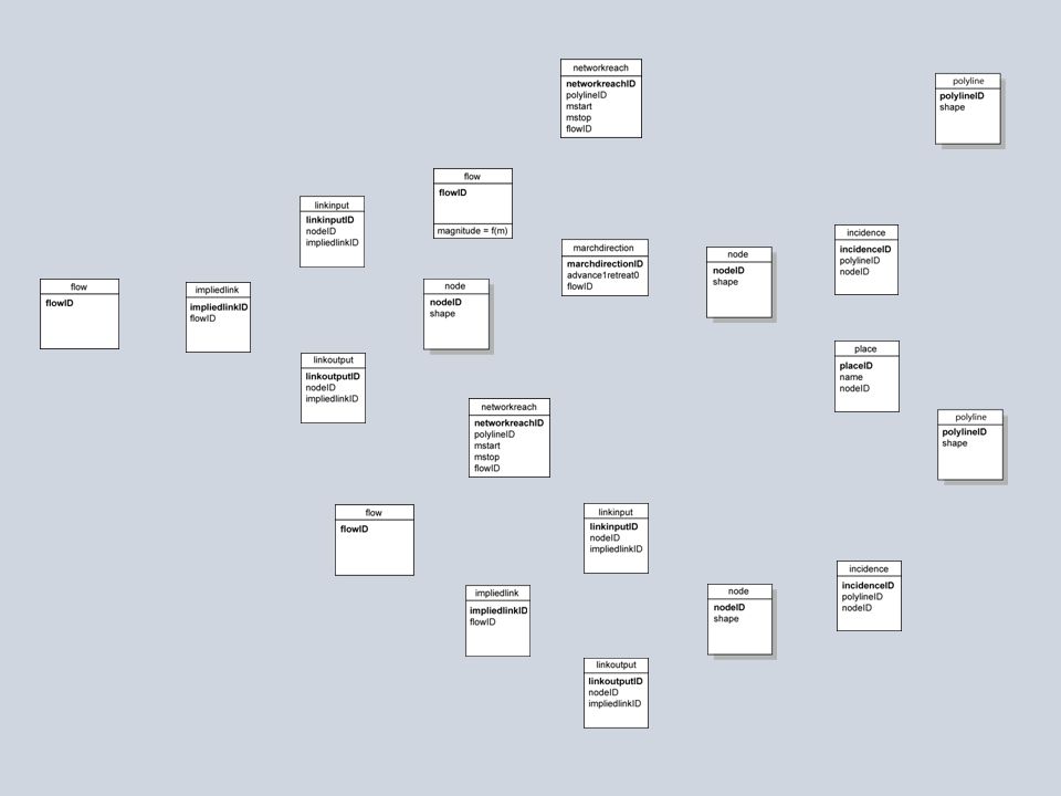
Tests of a data model provides "slots" to store everything relevant to the use case identifies the classes present on the map points, lines, areas, annotation specialization of lines as flows allows the map to be recreated from the data model

21
* * * * 0..1 0..2 0..1 ORIGINAL USE CASE MODELS INTERACTION MINARD NAPOLEON MAP KARST FLOW ROUTES

24
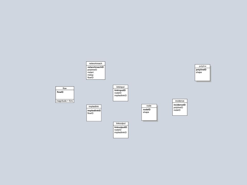
* * 0..1 0..2 0..1 Generic Flow Model

25
slide 13 / 22

26
Use Case: Human Migration slide 14 / 22

27
slide 15 / 22

28
Use Case: Minard Map slide 16 / 22

29
slide 17 / 22

30
Use Case: Karst Watershed Flow Routes slide 18 / 22

31
slide 19 / 22

34
Tobler’s Flow Mapper

35
Stand-alone, single-function software. Current version 1.1. Represents flows from an n x n interaction matrix and set of point coordinates (text files as inputs). Depicts two-way, net, and gross flows. Rapid calculation and visualization. Cartography handled semi- automatically (front-loaded cartography). Task-specific GIS: user is limited to the software’s existing analytical tools (customized queries are not possible). Creates SVG output. Flow Mapper
. Depicts two-way, net, and gross flows. Rapid calculation and visualization. Cartography handled semi- automatically (front-loaded cartography). Task-specific GIS: user is limited to the software’s existing analytical tools (customized queries are not possible). Creates SVG output. Flow Mapper.")
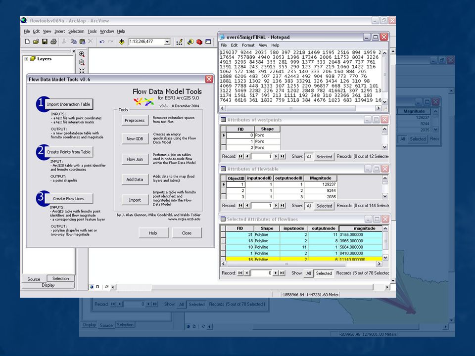
36
Flow Data Model Tools Set of ArcGIS macros to allow import, export, and visualization of flows using the Flow Data Model. Current version is beta, v0.69b. Coded and designed in VBA. Incorporates capabilities of Flow Mapper into ArcGIS, allowing flexibility of ArcGIS’ generalized spatial analysis platform. Calculates and represents gross, net, and two-way flows from the Flow Data Model. User responsible for cartographic output; relies on ArcGIS platform (end-loaded cartography). Interaction matrix import process is similar to Flow Mapper (requiring text files as input). Tasks are modularized to increase flexibility in data inputs and analysis. ArcGIS file types as outputs.
. Interaction matrix import process is similar to Flow Mapper (requiring text files as input). Tasks are modularized to increase flexibility in data inputs and analysis. ArcGIS file types as outputs..")
39
Integrate with specialized data models (ArcHydro, UNETRANS, etc) Finish data extraction functionality Finish FlowMapper importer Need to move to industrial strength code Need extensions to ArcGIS cartographic tools Ongoing & Future Work, and Wishlist slide 20 / 22 Alan in Talley Cave, KY / photo: C. Groves Alan in Coal Trace Cave, KY / photo: G. Berdeaux Generalize to the rectangular case (origins and destinations distinct) Flow on polyline Integrate with polyline m (flow as function of m) Within-feature flows Analysis routines Continuous (unchanneled) case (flow as a vector field) Animation of flows
 Flow on polyline Integrate with polyline m (flow as function of m) Within-feature flows Analysis routines Continuous (unchanneled) case (flow as a vector field) Animation of flows.")
40
Skogafoss, Iceland / photo: Glennon Acknowledgments Waldo Tobler, University of California, Santa Barbara Jack Dangermond and Rhonda Pfaff, ESRI Tom Cova, University of Utah May Yuan, University of Oklahoma

Similar presentations


 January 18, 2006 Learning Objectives:>")
 is a system designed to capture, store, manipulate, analyze, manage, and present all types of geographical.>")
