Download presentation
Presentation is loading. Please wait.

1
Creating a bigger, better, brighter future LGMA NSW General Managers & Directors Convention and Workshop 25 November 2011 Peter Goddard– Executive Manger LPI

2
Land & Property Information (LPI) is now part of the Department of Finance and Services Relationship strengthened through MoUs Spatial data exchange with local government Daily transactional updates Local government spatial data working groups NSW Comprehensive Property Addressing System (CPAS) Overview
 is now part of the Department of Finance and Services Relationship strengthened through MoUs Spatial data exchange with local government Daily transactional updates Local government spatial data working groups NSW Comprehensive Property Addressing System (CPAS) Overview")
3
Rates DA Approvals Surveys Plan Registration & Titles Valuations & Notice of Sale Local GovernmentLPI Survey Control Local cadastre State cadastre Environmental/ Planning Topographic/ Image Data Local Emergency Management Emergency information Building Partnership with Local Government CS2i (Spatial Council) Spatial group Address data E-planning (With DoP)
 Spatial group Address data E-planning (With DoP)")
4
SIX - Spatial Clearinghouse

5
SIX Components The Spatial Information eXchange is a cross government initiative to spatially enable NSW. It is a web based web portal that can: – Take you to any location in NSW – Show Information about that location – Inform you with relevant details on that location Spatial Data Infrastructure – SDI

6
Agreement to work together to: reduce duplication improve the quality of spatial data and facilitate reciprocal exchange of data Supported by a Products and Services Agreement (PSA) and associated Specifications of data to be exchanged 120 Councils have signed a MoU All councils have received a copy of the MoU and are encouraged to sign Relationship strengthened through Memorandum Of Understanding (MoU)
 and associated Specifications of data to be exchanged 120 Councils have signed a MoU All councils have received a copy of the MoU and are encouraged to sign Relationship strengthened through Memorandum Of Understanding (MoU)")
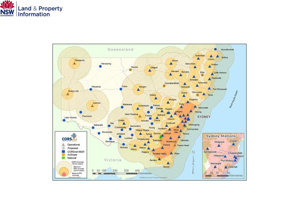
7
Sydney-Wollongong-Newcastle Autumn 2011 epoch

8
Available for; Digital Cadastral Database (DCDB) Digital Topographic Database (DTDB) Geo-coded Urban and Rural Address System (GURAS) – under test Applications available to suit all councils’ systems Seventy Councils (79 organisations in total) take DCDB incremental updates Provide more timely and accurate spatial data and minimises duplication of maintenance efforts Spatial data exchange - Incremental updates
 Digital Topographic Database (DTDB) Geo-coded Urban and Rural Address System (GURAS) – under test Applications available to suit all councils’ systems Seventy Councils (79 organisations in total) take DCDB incremental updates Provide more timely and accurate spatial data and minimises duplication of maintenance efforts Spatial data exchange - Incremental updates")
9
Collaborative arrangements with local councils to improve the quality of the local cadastral (mapping) fabric based on requests from local councils Additional survey control required 10cm imagery added to program Alternate strategy Target population centres with existing survey control 10cm imagery available or on program Other towns as control & imagery become available Spatial data exchange - DCDB upgrade
 fabric based on requests from local councils Additional survey control required 10cm imagery added to program Alternate strategy Target population centres with existing survey control 10cm imagery available or on program Other towns as control & imagery become available Spatial data exchange - DCDB upgrade")
10
Regional NSW High resolution digital imagery 50cm Ground Sample Distance (GSD) standard 10cm GSD in some towns (facilitates DCDB Upgrade) Sydney-Wollongong-Newcastle by RFQ Autumn epoch recently acquired (Sydney - Wollongong) Aiming for Spring & Autumn each year Spring acquisition RFQ in planning Collective, Whole of Government purchase Require seven agencies (whole area) contribution Cost to LG - ~$5/tile (ex GST) Spatial data exchange - Imagery
 standard 10cm GSD in some towns (facilitates DCDB Upgrade) Sydney-Wollongong-Newcastle by RFQ Autumn epoch recently acquired (Sydney - Wollongong) Aiming for Spring & Autumn each year Spring acquisition RFQ in planning Collective, Whole of Government purchase Require seven agencies (whole area) contribution Cost to LG - ~$5/tile (ex GST) Spatial data exchange - Imagery")
11
Sydney-Wollongong-Newcastle Autumn 2011 epoch

12
Other Spatial Initiatives Survey Control Information Management System (SCIMS) – Underpins the state’s survey control network Cadastral upgrade – Improving the NSW spatial data infrastructure Aerial imagery and LiDAR – Rolling programs Continuously Operating Reference Stations (CORS) – Providing real-time spatial accuracy
 – Underpins the state’s survey control network Cadastral upgrade – Improving the NSW spatial data infrastructure Aerial imagery and LiDAR – Rolling programs Continuously Operating Reference Stations (CORS) – Providing real-time spatial accuracy")
14
NSW Location Leadership Group Peak Spatial Body in NSW – Representatives from key agencies and Local Government Presently working on Location Strategy – Strategic input into spatial issues for Government and Local Government

15
NSW Location Leadership Group – Working Groups Emergency Services Water Addressing Local Government Imagery Spatial Information Management Framework (Metadata)
")
16
Cadastral Delivery - Lisa McFarlane (Wollondilly) Cadastral Upgrade – Thomas Baxter (Tamworth) Addressing - Steve Heapy (Sutherland) Information Interchange (SIX) - Paul Middleton (Eurobodalla) Crown Land - Carl Bennett (Port Macquarie) Imagery/LiDAR - Natalie Bennett (Wellington) Licensing/IP/Copyright - Scott Newman (Tweed) Metadata - Michael Troth (Geospatial Alliance, Junee) Local Government working groups
 Cadastral Upgrade – Thomas Baxter (Tamworth) Addressing - Steve Heapy (Sutherland) Information Interchange (SIX) - Paul Middleton (Eurobodalla) Crown Land - Carl Bennett (Port Macquarie) Imagery/LiDAR - Natalie Bennett (Wellington) Licensing/IP/Copyright - Scott Newman (Tweed) Metadata - Michael Troth (Geospatial Alliance, Junee) Local Government working groups")
17
Why does NSW need a Comprehensive Property Addressing System? The legislation and process for creating and distributing addresses does not support a clear, comprehensive, collaborative approach There is no single source of truth or central repository of official or trusted address information for NSW There is no governing body to assist and support Councils in rectifying inaccurate or ambiguous address information which poses a real risk to both Councils and the community There are many different ways in which address information is created and distributed

18
The CPAS Program objectives Legislative reform to provide for more efficient and accurate address creation and distribution in NSW Implementation of National Address Management Framework (NAMF) compliant processes The provision of more effective governance and support by modifying the role of the GNB to specifically include addressing matters The creation of a central, comprehensive, official geo-coded address database for NSW A stock take of Rural Addressing and the development and implementation of a collaborative strategy for its completion and ongoing maintenance
 compliant processes The provision of more effective governance and support by modifying the role of the GNB to specifically include addressing matters The creation of a central, comprehensive, official geo-coded address database for NSW A stock take of Rural Addressing and the development and implementation of a collaborative strategy for its completion and ongoing maintenance")
19
What’s in CPAS for councils and the community? Maximised value of the trusted and authoritative address information created by Councils Support for the community and industry through increased efficiency and effectiveness of emergency services, post and utility services Rapid identification of address locations including alias and vanity addresses Improved efficiency through a streamlined process for naming roads and automated two-way web distribution and notification services Single ‘source of truth’ address database which accurately represents all addresses Improved address search and validation services Property Address Confirmation Certificate to encourage the use of correct addresses Legislative reform along with a centralised distribution centre will mitigate the risks associated with inadequate addressing for Council and the community

20
Land subject to heritage restrictions is given a discounted land value Court decision in April 2011 threw doubt on this method The VG has lodged an appeal An Amendment to section 14G of the Valuation of Land Act passed through both houses of Parliament this week reconfirming the current methodology Heritage Valuations

21
Ombudsman’s review in 2005 established a program The 2006-11 program is coming to an end From 2012 the VG has authorised a revised program of land value verification for: Verification based on risk rating Verification with frequency based on risk Specification of the due diligence activities Land Value Verification Program

22
Peter Goddard Executive Manager Land and Property Information 9228 6659 Peter.goddard@lpi.nsw.gov.au Thank You

Similar presentations


>")


>")


>")
