Download presentation
Presentation is loading. Please wait.

2
…

3
Presented By DEEPAK KUMAR-10/ECE/54

4
Index INTRODUCTION HISTORY HOW IT WORKS? APPLICATION CONCLUSION

6
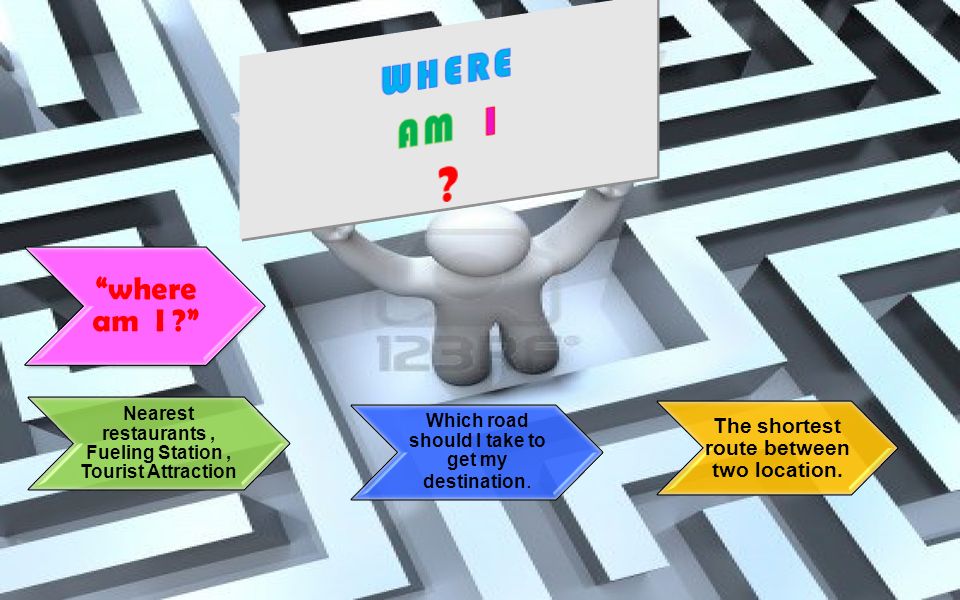
“where am I ?” Nearest restaurants, Fueling Station, Tourist Attraction Which road should I take to get my destination. The shortest route between two location.

7
Control Segment Space Segment User Segment Three Segments of the GPS Monitor Stations Ground Antennas Master Station

8
Position Of Satellite & Receiver 3 * Speed Of Light Distance between satellite and receiver = “3 times the speed of light” 3*Speed Of Light Satellite Receiver

9
Devices A.GPS Watch B.PDA with GPS C.Mobile Phone D.Hand Held

10
History 1969 – Defense Navigation satellite system (DNSS) formed. 1993 -- 24 th Satellite Launched ; initial Operational Capability. 1973 – NAVSTAR Global Positioning System developed. 1995 – Full operational capability. 1978 – First Four satellites launched, Delta Rocket Launch. MAY 2000 – Military accuracy available to all users.

11
Components of the System Space segment 24 satellite vehicles Inclined 55 o with respect to equator Orbits separated by 60o Six orbital planes20,200 km elevation above EarthOrbital period of 11 hr 55 min Block I Satellite Vehicle Five to eight satellites visible from any point on Earth

12
GPS Satellite Vehicle Four atomic clocks Three nickel-cadmium batteries Battery charging Power generation 1136 watts Two solar panels S band antenna—satellite control 12 element L band antenna— user communication Block IIF satellite vehicle (fourth generation)
")
13
GPS Satellite Vehicle

14
Kwajalein Atoll US Space Command Control Segment Hawaii Ascension Is. Diego Garcia Cape Canaveral Ground Antenna Master Control Station Monitor Station

15
GPS Communication and Control

16
How does GPS work? Satellite ranging FSatellite locations FSatellite to user distance FNeed four satellites to determine position Distance measurement FRadio signal traveling at speed of light FMeasure time from satellite to user Low-tech simulation

17
How does GPS work? how long a radio signal takes to reach us from that satellite. Distance to a satellite is determined by measuring how long a radio signal takes to reach us from that satellite. To make the measurement we assume that both the satellite and our receiver are generating the same pseudo-random codes at exactly the same time. By comparing how late the satellite's pseudo-random code appears compared to our receiver's code, we determine how long it took to reach us. Multiply that travel time by the speed of light and you've got distance.

18
System Performance Standard Positioning System

19
Application of GPS Technology LOCATION – Determining a basic position NAVIGATION – Getting from one location to another TRACKING – Monitoring the movement of people and things MAPPING – Creating maps of the world TIMING – Bringing precise timing to the world

20
Military.Search And Rescue.Disaster Relief.Surveying.Marine, Aeronautical And Terrestrial Navigation.Remote Controlled Vehicle And Robot Guidance.Satellite Positioning And Tracking.Shipping.Geographic Information Systems (GIS).Recreation. User Segment

21
CONCLUSION So, we have seen that Global positioning system is very popular & Essential to us. So, we can say, in future it will be developed more & more by taking help of advanced science & technology & we can use it in different fields of our life.

Similar presentations


 Precise positioning service.>")

 for Precision Farming>")


 Dated: 18.11.14 Advance Applications of RS/GIS in Geo-Environmental Conservation Subject Lecture-6.>")


 P.JANANI(110051101051) R.JANOFER FERHANA(110051101052) KADIRIMANGALAM JAHNAVI(110051101055)>")

