Download presentation
Presentation is loading. Please wait.

1
EARTH SCIENCE Prentice Hall EARTH SCIENCE Tarbuck Lutgens

2
16 Chapter 16 The Dynamic Ocean

3
What is an ocean current? 16.1 Ocean Currents Ocean current is the mass of ocean water that flows from one place to another. Surface Currents Surface currents are movements of water that flow horizontally in the upper part of the ocean’s surface. Surface currents develop from friction between the ocean and the wind that blows across its surface.

4
Ocean Surface Currents

5
What is a gyre and why do they spin? 16.1 Ocean Currents Gyres are huge circular-moving current systems that dominate the surfaces of the oceans. Water within gyres spin mainly due to the Coriolis effect, the deflection of currents away from their original course as a result of Earth’s rotation. All objects on earth are affected by the Coriolis effect. The Basics: objects in the northern hemisphere are turned to the right and objects in the southern hemisphere are turned to the left.

6
How do ocean currents affect climate? 16.1 Ocean Currents When currents from low-latitude regions move into higher latitudes, they transfer heat from warmer to cooler areas on Earth. As cold water currents travel toward the equator, they help moderate the warm temperatures of adjacent land areas.

7
False-Colored Satellite Image of the Gulf Stream Website: http://marine.rutgers.edu/cool/sat_data/?product=sst¬humbs=0 http://marine.rutgers.edu/cool/sat_data/?product=sst¬humbs=0

8
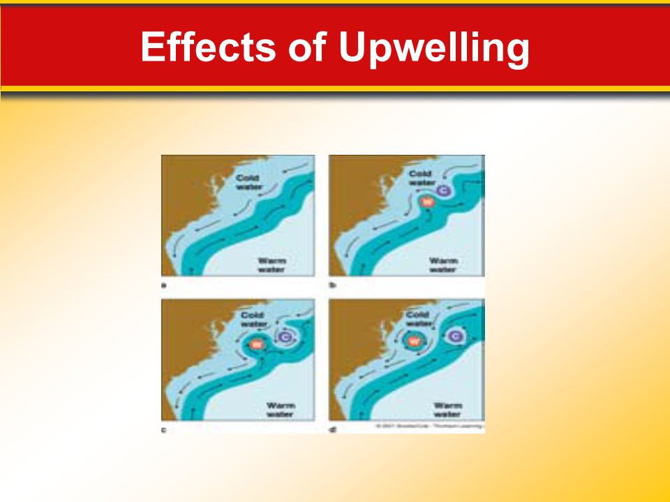
What is upwelling and how does it affect coastal areas? 16.1 Ocean Currents Upwelling is the rise of cold water from deeper layers to replace warmer surface water. Upwelling brings greater concentrations of dissolved nutrients, such as nitrates and phosphates, to the ocean surface. Upwelling on the Outer Banks?? What wind directions create this??

9
Effects of Upwelling

12
What other types of ocean circulation exist? 16.1 Ocean Currents Density currents are vertical currents of ocean water that result from density differences among water masses. The density of ocean water is greatly affected by temperature and salinity (saltiness). Generally, colder water is more dense than warmer water. More “salty” water is more dense than less “salty” water.
. Generally, colder water is more dense than warmer water. More salty water is more dense than less salty water..")
13
Deep-Ocean Circulation High Latitudes 16.1 The Composition of Seawater Most water involved in deep-ocean currents begins in high latitudes at the surface. Evaporation Density currents can also result from increased salinity of ocean water due to evaporation.

14
How does ocean water circulate throughout the earth? 16.1 Ocean Currents In a simplified model, ocean circulation is similar to a conveyor belt that travels from the Atlantic Ocean, through the Indian and Pacific Oceans, and back again.

15
Conveyor Belt Model

17
Cross Section of the Arctic Ocean

18
16.2 Waves and Tides

19
What are the characteristics of ocean waves? 16.2 Waves and Tides Most ocean waves obtain their energy and motion from the wind but some waves can be generated by earthquakes and landslides. The wave height is the vertical distance between the trough and crest. The wavelength is the horizontal distance between two successive crests or two successive troughs. The wave period is the time it takes one full wave—one wavelength—to pass a fixed position.

21
How does energy move throughout water? 16.2 Waves and Tides Circular orbital motion allows energy to move forward through the water while the individual water particles that transmit the wave move around in a circle.

22
What’s the difference between wind swell and groundswell? 16.2 Waves and Tides Wind swell generally has small wavelengths, short periods, and lose energy quickly. Groundswell has longer wavelengths, larger wave periods, and have more energy.

23
What is fetch and how does it affect ocean waves? 16.2 Waves and Tides Fetch is the distance that the wind has traveled across open water. The consistency, size, and power of waves that affect coastlines is greatly influenced by fetch. This explains why some coastlines have more consistent swells and why some bodies of water cannot generate large swells.

24
Fetch Building Waves

25
Waves and Tides What factors influence the characteristics of waves that hit a coastline? The height, length, and period that are eventually achieved by a wave depend on three factors: (1) wind speed, (2) length of time the wind has blown, and (3) fetch.
 wind speed, (2) length of time the wind has blown, and (3) fetch..")
26
Anatomy of a Wave

27
What causes waves to “break”? 16.2 Waves and Tides As swells approach a shallowing coastal zone, the waves touch bottom and the wave speed decreases. The decrease in wave speed results in a decrease in wavelength and an increase in wave height. The energy in the top part of the wave continues to travel at the same speed while the bottom wave energy slows down due to friction with the ocean floor (or sandbar, shoal, reef, etc.) The slowing down of the bottom of the wave causes the top part of the wave to “trip” over itself, thus causing the swell to “break”. NOAA Wave Lesson Link: http://www.montereyinstitute.org/noaa/lesson09.html http://www.montereyinstitute.org/noaa/lesson09.html
 The slowing down of the bottom of the wave causes the top part of the wave to trip over itself, thus causing the swell to break . NOAA Wave Lesson Link:")
28
Breaking Waves

29
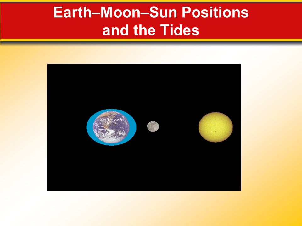
What are tides and what force creates them? Ocean tides result from the differences gravitational attraction exerted upon different parts of Earth’s surface by the moon and, to a lesser extent, by the sun. 16.2 Waves and Tides Tides are daily changes in the elevation of the ocean surface. The main force that produces tides is gravity. NOAA Tide Lesson Link: http://www.montereyinstitute.org/noaa/lesson10.html http://www.montereyinstitute.org/noaa/lesson10.html

31
Tide Bulges on Earth Caused by the Moon

33
What are the different types of tidal patterns that affect coastlines? 16.2 Waves and Tides Three main tidal patterns exist worldwide: diurnal tides (1 high, 1 low per day), semidiurnal tides (2 high, 2 low per day), and mixed tides (combo of diurnal and semidiurnal patterns). Transparency-Tidal Patterns.pdf Patterns are dependent upon several factors such as shape of coastline, depth, and bathymetry (shape of ocean floor). Tides occur 50 minutes later each day, thus it takes 24 hrs and 50 minutes to go through full tidal cycle (a lunar day).
, semidiurnal tides (2 high, 2 low per day), and mixed tides (combo of diurnal and semidiurnal patterns). Transparency-Tidal Patterns.pdf Patterns are dependent upon several factors such as shape of coastline, depth, and bathymetry (shape of ocean floor). Tides occur 50 minutes later each day, thus it takes 24 hrs and 50 minutes to go through full tidal cycle (a lunar day)..")
34
What are spring and neap tides? 16.2 Waves and Tides Spring tides are tides that have the greatest tidal range due to the alignment of the Earth–moon–sun system during full or new moons. These types of tides only occur during certain lunar (moon) events that have affects on the Tidal range, the difference in height between successive high and low tides. Neap tides are tides that have the lowest tidal range, occurring near the times of the first-quarter and third-quarter phases of the moon.
 events that have affects on the Tidal range, the difference in height between successive high and low tides. Neap tides are tides that have the lowest tidal range, occurring near the times of the first-quarter and third-quarter phases of the moon..")
35
Earth–Moon–Sun Positions and the Tides

37
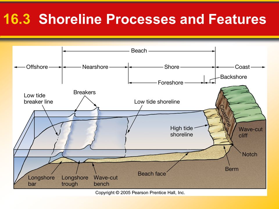
What really is a “beach”? A beach is the accumulation of sediment found along the shore of a lake or ocean. Many forces such as wave impact, tides, coastal storm frequency, and abrasion help to form many shoreline features. Video: From_By_the_Sea_to_Under_the_Sea__B each_Erosion__Depleting_Our_Coasts.asf From_By_the_Sea_to_Under_the_Sea__B each_Erosion__Depleting_Our_Coasts.asf 16.3 Shoreline Processes and Features

39
What is wave refraction and how does it affect a coast? 16.3 Shoreline Processes and Features Wave refraction is the bending of waves, and it plays an important part in the shoreline process. Because of refraction, wave energy is concentrated against the sides and ends of headlands that project into the water, whereas wave action is weakened in bays.

40
Wave Refraction

44
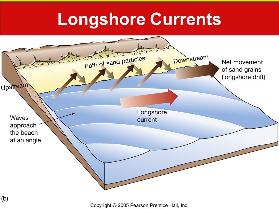
What are longshore currents? 16.3 Shoreline Processes and Features A longshore current is a near-shore current that flows parallel to the shore. In general, sediments are moved southward along Atlantic and Pacific coasts of U.S. due to large “nor’easter” storms during winters.

45
Longshore Currents

47
How do shoreline features differ? There are 2 basic types of shorelines: (1) erosional and (2) depositional Shoreline features that originate primarily from the work of erosion are called erosional features. There are several types of erosional features: 16.3 Shoreline Processes and Features
 erosional and (2) depositional Shoreline features that originate primarily from the work of erosion are called erosional features. There are several types of erosional features: 16.3 Shoreline Processes and Features.")
48
Erosional Features Wave-Cut Cliffs and Platforms 16.3 Shoreline Processes and Features Sea Arches, sea caves,and Sea Stacks Headlands

49
Erosional Shoreline Features

50
Original Land surface Wave-cut platform stump stack Natural Arch Old cliff line Erosional Shoreline Features

51
Wave-cut platform Wave built terrace

52
U.S. Coastlines

53
What types of features are created on depositional shorelines? 16.3 Depositional Features Where longshore currents and other surf zone currents are active, several features related to the movement of sediment along the shore may develop. - A spit is an elongated ridge of sand that projects from the land into the mouth of an adjacent bay. - A baymouth bar is a sandbar that completely crosses a bay. - A tombolo is a ridge of sand that connects an island to the mainland or to another island.

54
16.3 Depositional Features Other depositional features: Tidal delta- A sand bar or shoal formed in the entrance of an inlet by the action of reversing tidal currents. Barrier islands- a coastal landform that is relatively narrow strips of sand that parallel the mainland coast. They usually occur in chains, consisting of anything from a few islands to more than a dozen and are separated from the mainland by a shallow sound, bay or lagoon.

55
Evolution of Shoreline Features

56
16.3 Shoreline Processes and Features

57
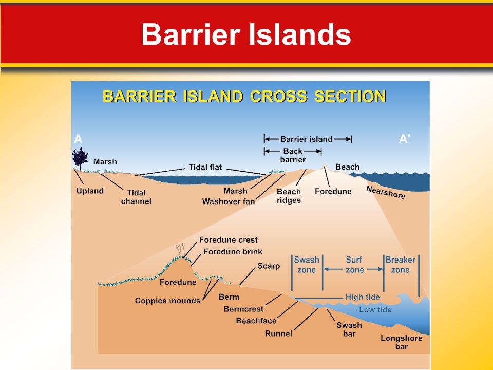
Do all barrier islands look the same? 16.3 More on Barrier Islands All barrier islands consist of three parts, including the beach, the dune (which protects the rest of the island from the beach and is naturally stabilized with plants), and the barrier flat (or the backbone), which is the remaining part of the island.
, and the barrier flat (or the backbone), which is the remaining part of the island..")
58
Barrier Islands

63
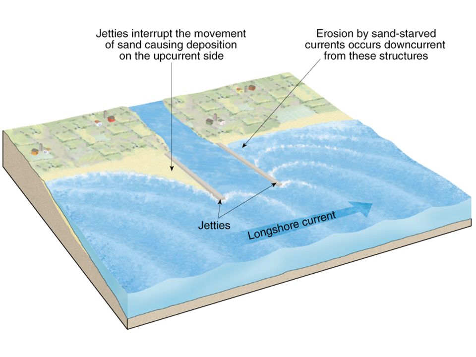
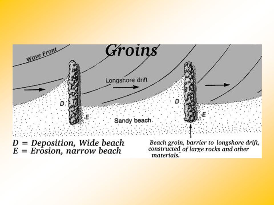
How do we protect our coastal property? Protective Structures 16.3 Shoreline Processes and Features Groins, breakwaters, and seawalls are some structures built to protect a coast from erosion or to prevent the movement of sand along a beach. Beach Nourishment Beach nourishment is the addition of large quantities of sand to the beach system.

64
16.3 Shoreline Processes and Features

67
Breakwater Structures

68
16.3 Shoreline Processes and Features

69
16.3 The Only Seawall on the O.B.

70
Miami Beach Before and After Beach Nourishment

71
Nags Head Before and After

72
Beach Nourishment Video: Town of Nags Head -- March 10 2010 Beach VideoTown of Nags Head -- March 10 2010 Beach Video http://www.nagsheadnc.gov/index.asp?Type=B_B ASIC&SEC={CBEDDF76-A552-41B8-A6E0- BF260CB010D9}

73
We can always move things….

Similar presentations