Download presentation
Presentation is loading. Please wait.

1
InterRisk Environmental risk management in marine and coastal areas of Europe Project No. 035253 supported by EC FP6 IST http://interrisk.nersc.no http://interrisk.ucc.ie http://www.marine.ie

2
Thank you! InterRisk Project EU 6th Framework Programme Partners include –Nansen Environmental and Remote Sensing Center; Norway –Coastal and Marine Resources Centre, UCC (CMRC); Ireland –SPACEBEL S.A./N.V. (SPB); Belgium –Centre de Documentation, de Recherche et d'Expérimentations sur les Pollutions Accidentelles des Eaux (CEDRE); France –Plymouth Marine Laboratory (PML); UK –GKSS-Forschungszentrum Geesthacht GmbH (GKSS); Germany –Norwegian Meteorological Institute (met.no); Norway –Norwegian Institute for Water Research (NIVA); Norway –Institut Francais de Recherche pour l'Exploitation de la Mer (IFREMER); France –Marine Institute (MI); Ireland –Universita' del Piemonte Orientale (UNIPO); Italy –Institut fuer Neuroinformatik, Ruhr-Universitaet, Bochum (INI); Germany –OPTIMARE Sensorsysteme AG (Optimare); Germany –Institute of Oceanology, Polish Academy of Sciences (IOPAN); Poland –Innova Consorzio per L’Informatica e la Telematica (INNOVA); Italy
; Ireland –SPACEBEL S.A./N.V. (SPB); Belgium –Centre de Documentation, de Recherche et d Expérimentations sur les Pollutions Accidentelles des Eaux (CEDRE); France –Plymouth Marine Laboratory (PML); UK –GKSS-Forschungszentrum Geesthacht GmbH (GKSS); Germany –Norwegian Meteorological Institute (met.no); Norway –Norwegian Institute for Water Research (NIVA); Norway –Institut Francais de Recherche pour l Exploitation de la Mer (IFREMER); France –Marine Institute (MI); Ireland –Universita del Piemonte Orientale (UNIPO); Italy –Institut fuer Neuroinformatik, Ruhr-Universitaet, Bochum (INI); Germany –OPTIMARE Sensorsysteme AG (Optimare); Germany –Institute of Oceanology, Polish Academy of Sciences (IOPAN); Poland –Innova Consorzio per L’Informatica e la Telematica (INNOVA); Italy.")
3
InterRisk Goals Design and implement a system architecture for interoperable GMES services Develop ontologies and application schemas for InterRisk services Develop specific interoperable service components compliant with SSE (Service Support Environment) and Open Geospatial Consortium specifications Develop data repository services for data to be used in GMES Integrate services with the developed service components and provide customised products through a network of services in major European coastal and marine areas Validate the usefulness of products and services delivered by InterRisk to users and solicit feedback for improvement of the products and services. Disseminate products and services to participants in GMES projects and to users responsible for environmental risk management and emergency handling in coastal regions.

4
InterRisk Work Packages WP100 –system requirements WP200 –system architecture design WP300 –ontology's and application schemas WP400 –WP410 data repository service –WP410 metadata repository service –WP420 SSE service components –WP430 data distribution services WP500 –regional services Norwegian waters UK/Irish waters French waters German/Polish waters Italian waters WP600 –validation, evaluation and impact assessment WP700 –dissemination and exploitation

5
InterRisk WP100 System Requirements Application domains –Oil spill –Harmful Algal Blooms (HAB) –Eutrophication –Environmental degradation Technological platform and adopted standards –W3C –Open Geospatial Consortium Secure Interoperable Employ best practice from previous GMES projects (OASIS, DISMAR, ORCHESTRA) Service deployment in the SSE framework
 –Eutrophication –Environmental degradation Technological platform and adopted standards –W3C –Open Geospatial Consortium Secure Interoperable Employ best practice from previous GMES projects (OASIS, DISMAR, ORCHESTRA) Service deployment in the SSE framework")
6
InterRisk WP100 Adopted Standards World Wide Web Consortium (W3C) –standards organization for the World Wide Web Open Geospatial Consortium (OGC) –Web Map Service (WMS) maps of spatially referenced data dynamically from geographic information. –Web Feature Service (WFS) an interface allowing requests for geographical vector features as AXM based GML data. –Web Coverage Service (WCS) an interface allowing requests for raster gridded data using XML encoding. –Catalogue Service for the Web (CSW) common standard to discover, browse, and query metadata about data, services, and other potential resources. International Standards Organisation (ISO) –ISO19115:2003 defines the schema required for describing geographic information and services. –ISO19119:2005 Identifies and defines the architecture patterns for service interfaces used for geographic information. –ISO19139:2007 Defines Geographic Metadata XML (gmd) encoding, an XML schema implementation derived from ISO19115 standard.
 an interface allowing requests for geographical vector features as AXM based GML data. –Web Coverage Service (WCS) an interface allowing requests for raster gridded data using XML encoding. –Catalogue Service for the Web (CSW) common standard to discover, browse, and query metadata about data, services, and other potential resources. International Standards Organisation (ISO) –ISO19115:2003 defines the schema required for describing geographic information and services. –ISO19119:2005 Identifies and defines the architecture patterns for service interfaces used for geographic information. –ISO19139:2007 Defines Geographic Metadata XML (gmd) encoding, an XML schema implementation derived from ISO19115 standard..")
7
InterRisk WP200 System Architecture Design

8
A common vocabulary for describing the concepts that exist in an area of knowledge and the relationships that exist between them. –Oil Spill –Harmful Algal Blooms –Eutrophication Web Ontology Language (OWL) Application Schemas reviewed –GML –Marine XML –WIN Oil Spills –Marine Data Model GML Keywords –ISO Discipline –Theme –Place –Stratum –Organisation –Parameter –Platform –Instrument Discovery metadata profile –ISO19139:2007 XML schema InterRisk WP300 Ontology’s and Application Schemas
 Application Schemas reviewed –GML –Marine XML –WIN Oil Spills –Marine Data Model GML Keywords –ISO Discipline –Theme –Place –Stratum –Organisation –Parameter –Platform –Instrument Discovery metadata profile –ISO19139:2007 XML schema InterRisk WP300 Ontology’s and Application Schemas.")
9
Data Repository Service –Marine Institute HAB’s database –SQL Server extraction routines –ArcGIS Model Builder –SQL Server database –ArcSDE feature class Metadata Repository Service –CMRC GeoNetwork server –InterRisk Template Vector Data metadata schema –Default View metadata creation –XML View metadata creation – copy schema InterRisk WP410 data repository service (including metadata)
")
10
Harmful Algal Blooms –SQL Server –ArcGIS ArcSDE feature class InterRisk WP410 data repository service

11
GeoNetwork –InterRisk Discovery Metadata Profile (2008) of ISO19139:2007 InterRisk WP410 metadata repository service
 of ISO19139:2007 InterRisk WP410 metadata repository service")
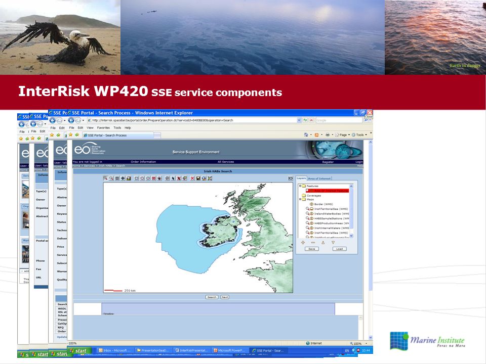
12
Services Support Environment –expanding resource of Earth observation and GIS services –secure –http://interrisk.spacebel.be Features –WFS client –WMS client –Ontology editor and database –CSW distributed metadata catalogue –EO data ordering and download InterRisk WP420 SSE service components

14
InterRisk WP430 data distribution services Web Map Service (WMS) –ArcGIS Server WMS Server –Deegree –GeoServer –UMN MapServer Web Feature Service (WFS) –ArcGIS Server WFS Server –Deegree –GeoServer –UMN MapServer Web Coverage Service (WCS) –THREDDS –Deegree –GeoServer –UMN MapServer Catalogue Service for the Web (CSW) –GeoNetwork OPenDAP –publish or access data via the World Wide Web without the necessity to download the data to a local file system
 –ArcGIS Server WMS Server –Deegree –GeoServer –UMN MapServer Web Feature Service (WFS) –ArcGIS Server WFS Server –Deegree –GeoServer –UMN MapServer Web Coverage Service (WCS) –THREDDS –Deegree –GeoServer –UMN MapServer Catalogue Service for the Web (CSW) –GeoNetwork OPenDAP –publish or access data via the World Wide Web without the necessity to download the data to a local file system")
15
InterRisk WP500 basic products and services Norwegian waters –The Norwegian Oil Spill service (NORHAB) –The Norwegian Harmful Algal Bloom service (NOROIL) UK and Irish waters –The UK and Ireland HAB service French waters –The French Oil Spill service German and Polish waters –German Potential Oil Slick service (GERPOS) –German Novelty Detection service (GERNOS) Italian waters –The Italian Oil Slick Detection service (ITOSD)
 –The Norwegian Harmful Algal Bloom service (NOROIL) UK and Irish waters –The UK and Ireland HAB service French waters –The French Oil Spill service German and Polish waters –German Potential Oil Slick service (GERPOS) –German Novelty Detection service (GERNOS) Italian waters –The Italian Oil Slick Detection service (ITOSD)")
16
InterRisk WP500 UK and Ireland Algal Bloom Service Base Reference Data MODIS real time satellite MERIS real time satellite IREHAB Sample Stations IREHAB Production Area

17
InterRisk WP600 validation End-users –Irish Food Safety Authority –Irish Sea Fisheries Protection Authority –Irish Shellfish Industry –Marine Institute HABs team Advisory Group GMES project leaders IST Project Review Group

18
InterRisk WP700 dissemination and exploitation Presentation –SeaDataNet Plenary Meeting Brochure –UK and Ireland Algal Bloom service –French Oil Spill Monitoring service –InterRisk System –InterRisk fact sheet Workshop –Annual Irish Shellfish Safety Workshop –SSE Service Providers –GEO European Project Conference –3 rd Nordic Marine Science Conference –INFOBAZY 2008 –Irlogi 2008 –IMDIS 2008 –NOOS 2007 Journals –Marine Geodesy

19
InterRisk Deliverables Interoperable GMES Open Source GIS Open Standards Metadata Data Sharing Data Integration Data Management

20
InterRisk Muchas gracias por escuchar y tenéis preguntas? Environmental risk management in marine and coastal areas of Europe Project No. 035253 supported by EC FP6 IST

Similar presentations


 SWIM Application Asia/Pacific AMHS/SWIM Workshop Chaing Mai, Thailand March 5-7, 2012 Tom McParland,>")


 Declan Dunne 13 th February 2008, Athens.>")


: Use of GIS for making statistics.>")