Download presentation
Presentation is loading. Please wait.

1
Canada Presentation for Unit 5 “Going to Places: The World of Travelling” English VIII O. Afanasieva, I.Mikheeva “Prosveschenie”2012 Kuznetsova L.I. gymnasium 295 St. Petersburg 2013

2
Provinces and Territories of Canada

3
AlbertaAlberta (Edmonton) Alberta is the western most "prairie province". It also happens to be where my family and I live. Edmonton is the capital city. Alberta became a province of Canada in 1905. The Rocky Mountains run down the border of Alberta and British Columbia and extend into the United States.

4
British ColumbiaBritish Columbia (Victoria) British Columbia, British Columbia is the western most Canadian province. Victoria is the capital city. The Rocky Mountains run down the border of Alberta and British Columbia and extend into the United States.

5
Manitoba Manitoba is the eastern-most of the "prairie provinces". Winnipeg is the capital city. Manitoba became a province of Canada on July 15, 1870. Winnipeg is Manitoba's capital and largest city. It is also Canada's eighth-largest city and home to 60% of the population of the province of Manitoba. Winnipeg is the seat of the provincial government for Manitoba. Four of the province's five universities, all four of its professional sports teams, and most of its cultural activities are located in Winnipeg.

6
New BrunswickNew Brunswick (Fredericton) New Brunswick is one of Canada's ten provinces. It is an Atlantic or "Maritime" province. It can be found on the East Coast of the country, near the Atlantic Ocean. New Brunswick joined the Canadian Confederation in 1867. The purple violet was adopted as the official flower of New Brunswick in 1936, at the request of the provincial Women's Institute

7
Ontario Ontario is the second largest Canadian province (in terms of area) and can be found on the map between Manitoba and Quebec. Toronto is the capital city of Ontario. Ottawa, the capital of Canada, is in Ontario. Ontario joined the Canadian Confederation in 1867. Ontario includes part of "the Great Lakes". The Great Lakes consist of Lake Erie, Lake Huron, Lake Michigan, Lake Ontario and Lake Superior. Lake Superior is the largest of the great lakes and also has the largest surface area of any freshwater lake in the world. The border between Canada (Ontario) and the United States runs through Lake Superior, Lake Huron, Lake Erie and Lake Ontario. Lake Michigan is entirely in the United States. Environmental management of the Great Lakes is a joint effort between the two countries.
 and the United States runs through Lake Superior, Lake Huron, Lake Erie and Lake Ontario. Lake Michigan is entirely in the United States. Environmental management of the Great Lakes is a joint effort between the two countries..")
8
Northwest TerritoriesNorthwest Territories(Yellowknife) Northwest Territories is the central Canadian territory. Yellowknife is the capital city. Up until, 1999 the Northwest Territories were twice the size. On April 1, 1999, it was split to recognize Nunavut as a separate territory. The official bird of the Northwest Territories is the gyrfalcon (Falco rusticolus). It was adopted as the official bird in 1990.
. It was adopted as the official bird in")
10
Native populationTerritoryTime zones Capital CurrencySymbol, Flag

11
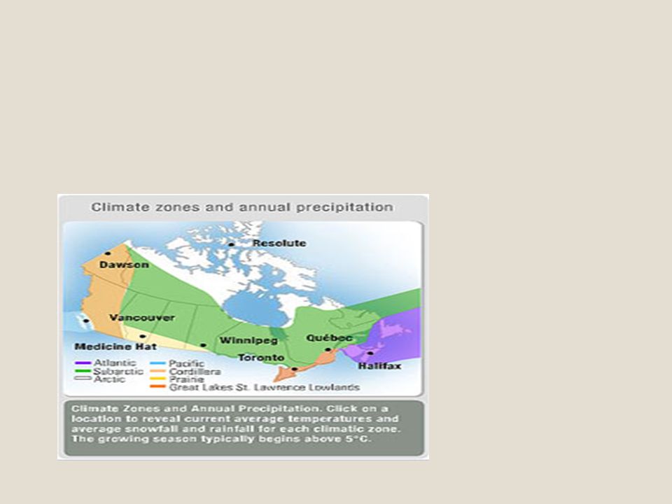
Toronto Resolute Vancouver Dawson Climate in the cities:

12
Climate is a region’s weather over a long period. Canada has seven climatic zones. Southern Ontario enjoys warm, humid summers and short, cold winters, because of the moderating influence of the Great Lakes. The mountainous interior of British Columbia and the Yukon Territory support glaciers on the summits and semideserts in the valleys. Latitude — the distance north or south of the equator — influences whether a climate is cold or hot. The midlatitude Prairies experience continental extremes: cold winters and hot, dry summers. The high-latitude Arctic endures intensely dry and frigid conditions. The largest zone by far is the Subarctic, which knows short, cool summers and long, cold winters, and low precipitation. All of southern Canada is classified as “temperate” — that is, it has four seasons. Winter touches all zones, save the Pacific, where warm winds promote a mild, rainy climate year-round. By contrast, the prevailing west-to-east winds moving across central Canada bring cool, humid summers and short, cool winters to Atlantic Canada.

14
Canada.Population

Similar presentations


 How would you describe the geography of Canada? 2) How do geographic features affect how people live?>")