Download presentation
Presentation is loading. Please wait.

1
Department of Science and Technology Philippine Atmospheric, Geophysical and Astronomical Services Administration (PAGASA) Science Garden Complex, Agham Rd., Diliman, Quezon City, Philippines FERNANDO R. CADA CAD/PAGASA/DOST Presented by Climate Review ( September - October 2010) Climate Review ( September - October 2010) 43 rd Climate Outlook Forum, PAGASA Amihan Conference Room, Quezon City, 26 October 2010
 Climate Review ( September - October 2010) 43 rd Climate Outlook Forum, PAGASA Amihan Conference Room, Quezon City, 26 October")
2
General Relationship El Niño Southern Oscillation (ENSO) + SSTA - -SOI EL NIÑO + SOI - -SSTA LA NIÑA TRADE WINDS
 + SSTA - -SOI EL NIÑO + SOI - -SSTA LA NIÑA TRADE WINDS")
3
September Negative sea surface temperature (SST) anomalies continued to strengthen across the equatorial Pacific Ocean. The monthly Niño indices were -1.6°C for Niño 3.4 Equatorial low-level easterly trade winds remained stronger than average over the western and central Pacific. The Southern Oscillation Index (SOI) value for September is +25.0 Collectively, these oceanic and atmospheric anomalies reflect a strengthening of La Niña conditions. La Niña Conditions La Niña Conditions CPC/NCEP/NOAA -1.6°C
 value for September is Collectively, these oceanic and atmospheric anomalies reflect a strengthening of La Niña conditions. La Niña Conditions La Niña Conditions CPC/NCEP/NOAA -1.6°C.")
4
La Niña Conditions La Niña Conditions CPC/NCEP/NOAA

5
YEARYEAR JANFEBMARAPRMAYJUNJULAUGSEPOCTNOVDEC 20102010 -10.1-14.5-10.615.210.01.820.518.825.0-- SOI (Southern Oscillation Index ) BOM-Australia
 BOM-Australia")
6
October The central Pacific Ocean temperatures are comparable to those observed during previous moderate events, such as 1998 and 2007. The central Pacific Ocean is more than 1°C cooler than the long-term mean at the surface. Trade winds are stronger than normal over the western Pacific. The SOI remains above +20.0 ENSO indicators remain firmly at La Niña levels La Niña Conditions La Niña Conditions

7
SSTAnomaly 1998 2007 IRI/Columbia Univ. CPC/NCEP/NOAA

8
850 hPa Wind Anom CPC/NCEP ; BOM-Australia

9
PAGASA/DOST Press Release on La Niña Press Release on La Niña PRESS RELEASE Date: September 30, 2010 ONSET OF LA NIÑA 2010 Early stages of cold conditions in the equatorial Pacific ocean that started in July 2010 continue to persist and further strengthened reaching the La Niña threshold level, as shown by the recent oceanic and atmospheric indicators. It is now a weak to moderate La Niña event and is likely to continue at least until early 2011, as suggested by the dynamical and statistical model forecasts. La Niña periods are usually associated with above normal rainfall across most areas of the country during the last quarter of the year and early months (Jan-Mar) of the following year. Climate pattern in the country during the months of August and September (Northern Hemisphere summer) was generally influenced by the moderate to strong easterlies, one of the key indicators of typical La Niña event. Impact of this was below normal rainfall in most areas of Luzon during August and most areas of the country during September indicated weak southwest monsoon activity. With the persistent anomalous strength of the easterlies over the central and western tropical Pacific, enhanced rainfall during October-December season is likely, coinciding with the start of the northeast monsoon period. Near normal to above normal rainfall condition is expected over most areas of Luzon and generally, near normal over the rest of the country. The weak to moderate La Niña is expected to continue and may adversely impact on domestic water supply, agriculture and the health sector. This may cause flood, flashflood and rain- triggered land slide in hazard-prone areas. Meanwhile, all government agencies and the public are advised to take appropriate measures to mitigate the potential impacts of the present La Niña event in the equatorial Pacific. The PAGASA will continue to closely monitor these conditions and regular updates/advisories shall be issued as appropriate. GRACIANO P. YUMUL, Jr., D.Sc. Officer-in-Charge Office of the Administrator
 of the following year. Climate pattern in the country during the months of August and September (Northern Hemisphere summer) was generally influenced by the moderate to strong easterlies, one of the key indicators of typical La Niña event. Impact of this was below normal rainfall in most areas of Luzon during August and most areas of the country during September indicated weak southwest monsoon activity. With the persistent anomalous strength of the easterlies over the central and western tropical Pacific, enhanced rainfall during October-December season is likely, coinciding with the start of the northeast monsoon period. Near normal to above normal rainfall condition is expected over most areas of Luzon and generally, near normal over the rest of the country. The weak to moderate La Niña is expected to continue and may adversely impact on domestic water supply, agriculture and the health sector. This may cause flood, flashflood and rain- triggered land slide in hazard-prone areas. Meanwhile, all government agencies and the public are advised to take appropriate measures to mitigate the potential impacts of the present La Niña event in the equatorial Pacific. The PAGASA will continue to closely monitor these conditions and regular updates/advisories shall be issued as appropriate. GRACIANO P. YUMUL, Jr., D.Sc. Officer-in-Charge Office of the Administrator.")
10
PAGASA/DOST Press Conference on La Niña Onset Press Conference on La Niña Onset (October 04, 2010)
")
11
PAGASA/DOST La Niña Advisory # 1 LA NIÑA ADVISORY No. 1 Persistent cooling of the sea surface temperature (SST) in the central and eastern equatorial Pacific ocean reached the La Niña threshold level last July 2010 as shown by the key atmospheric and oceanic indicators. This further strengthened and is now a weak to moderate La Niña event and likely to continue at least until early 2011, as suggested by the dynamical and statistical model forecasts. The climatic condition in the country during the last two months was generally influenced by the moderate to strong easterlies, one of the key indicators of typical La Niña event. Impact of this was below normal rainfall in most areas of Luzon during August and most areas of the country during September, which indicated a weak southwest monsoon activity. The other weather systems that affected the country during September were the ridge of high pressure area (HPA), intertropical convergence zone (ITCZ), low pressure area (LPA) and two (2) tropical cyclones namely: Tropical Storm “Henry” (September 3 - 4), and Typhoon “Inday” (September 15 - 19). These tropical cyclones have no significant effect on the rainfall distribution of the country during the month. Rainfall assessment for September was below normal in most parts of Luzon, Leyte province and Eastern Mindanao. Near to above normal rainfall was observed over most areas of the Bicol region, Central Visayas, Western and Central Mindanao. Average air temperatures observed during September were slightly warmer than normal in most parts of the country. The actual ranges were as follows: 23 0 C to 34 0 C over the lowlands of Luzon, 16 0 C to 24 0 C for the mountainous areas of Luzon, 24 0 C to 33 0 C for Visayas, 22 0 C to 34 0 C over the lowlands of Mindanao, and 17 0 C to 31 0 C over the mountainous areas of Mindanao. Gradual shift of the wind from the southwest to the northeast flow is generally experienced during the later part of September up to October. However, due to the present La Niña event, prevalence of the NE wind flow was already observed. The northeast (NE) monsoon, ITCZ, the tail end of the cold front, ridge of HPA and three (3) or four (4) tropical cyclones are the weather systems likely to affect the country in October. There is a probability of above normal rainfall condition to be experienced over some areas of Central Luzon, Bicol region, Mindoro provinces and the northern portion of Panay island and generally near normal over the rest of the country. Predicted ranges of temperature for October are: for Luzon, 22 0 C to 32 0 C, the mountainous areas of Luzon from 16 0 C to 24 0 C, the Visayas from 23 0 C to 32 0 C, Mindanao from 22 0 C to 32 0 C, and the mountainous areas of Mindanao from 18 0 C to 28 0 C. PAGASA will continue to monitor the day-to-day weather conditions and the large-scale climatic patterns that will affect the country. Updates/advisories on the on-going La Niña shall be issued as appropriate. GRACIANO P. YUMUL, Jr., D.Sc. Officer-In-Charge Office of the Administrator Issued : October 07, 2010
 in the central and eastern equatorial Pacific ocean reached the La Niña threshold level last July 2010 as shown by the key atmospheric and oceanic indicators. This further strengthened and is now a weak to moderate La Niña event and likely to continue at least until early 2011, as suggested by the dynamical and statistical model forecasts. The climatic condition in the country during the last two months was generally influenced by the moderate to strong easterlies, one of the key indicators of typical La Niña event. Impact of this was below normal rainfall in most areas of Luzon during August and most areas of the country during September, which indicated a weak southwest monsoon activity. The other weather systems that affected the country during September were the ridge of high pressure area (HPA), intertropical convergence zone (ITCZ), low pressure area (LPA) and two (2) tropical cyclones namely: Tropical Storm Henry (September 3 - 4), and Typhoon Inday (September ). These tropical cyclones have no significant effect on the rainfall distribution of the country during the month. Rainfall assessment for September was below normal in most parts of Luzon, Leyte province and Eastern Mindanao. Near to above normal rainfall was observed over most areas of the Bicol region, Central Visayas, Western and Central Mindanao. Average air temperatures observed during September were slightly warmer than normal in most parts of the country. The actual ranges were as follows: 23 0 C to 34 0 C over the lowlands of Luzon, 16 0 C to 24 0 C for the mountainous areas of Luzon, 24 0 C to 33 0 C for Visayas, 22 0 C to 34 0 C over the lowlands of Mindanao, and 17 0 C to 31 0 C over the mountainous areas of Mindanao. Gradual shift of the wind from the southwest to the northeast flow is generally experienced during the later part of September up to October. However, due to the present La Niña event, prevalence of the NE wind flow was already observed. The northeast (NE) monsoon, ITCZ, the tail end of the cold front, ridge of HPA and three (3) or four (4) tropical cyclones are the weather systems likely to affect the country in October. There is a probability of above normal rainfall condition to be experienced over some areas of Central Luzon, Bicol region, Mindoro provinces and the northern portion of Panay island and generally near normal over the rest of the country. Predicted ranges of temperature for October are: for Luzon, 22 0 C to 32 0 C, the mountainous areas of Luzon from 16 0 C to 24 0 C, the Visayas from 23 0 C to 32 0 C, Mindanao from 22 0 C to 32 0 C, and the mountainous areas of Mindanao from 18 0 C to 28 0 C. PAGASA will continue to monitor the day-to-day weather conditions and the large-scale climatic patterns that will affect the country. Updates/advisories on the on-going La Niña shall be issued as appropriate. GRACIANO P. YUMUL, Jr., D.Sc. Officer-In-Charge Office of the Administrator Issued : October 07,")
12
Prevailing Weather Systems (September – October 2010) Moderate to Strong Easterlies Weak Southwest Monsoon Intertropical Convergence Zone (ITCZ) Low Pressure Areas Ridge of High Pressure Area Northeast Monsoon Tropical Cyclones : Sep = 2 Oct = 2 (as of Oct 26)
 Moderate to Strong Easterlies Weak Southwest Monsoon Intertropical Convergence Zone (ITCZ) Low Pressure Areas Ridge of High Pressure Area Northeast Monsoon Tropical Cyclones : Sep = 2 Oct = 2 (as of Oct 26)")
14
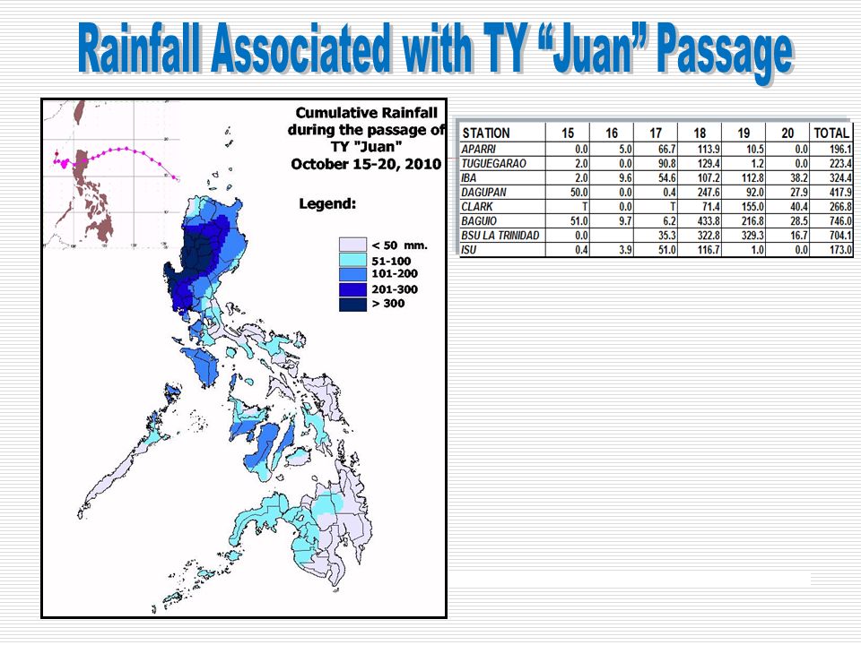
Rainfall in September 2010 RAINFALL ASSESSMENT: Rainfall condition for September was below normal in most parts of Luzon, Leyte provinces and Eastern Mindanao. Near to above normal rainfall was observed over most areas of the Bicol region, Central Visayas, Western and Central Mindanao.

17
Rainfall in October 2010 RAINFALL ASSESSMENT: Most areas of the western section of the country were above to near normal rainfall conditions for October while below to near normal over the rest of the Philippine archipelago.

18
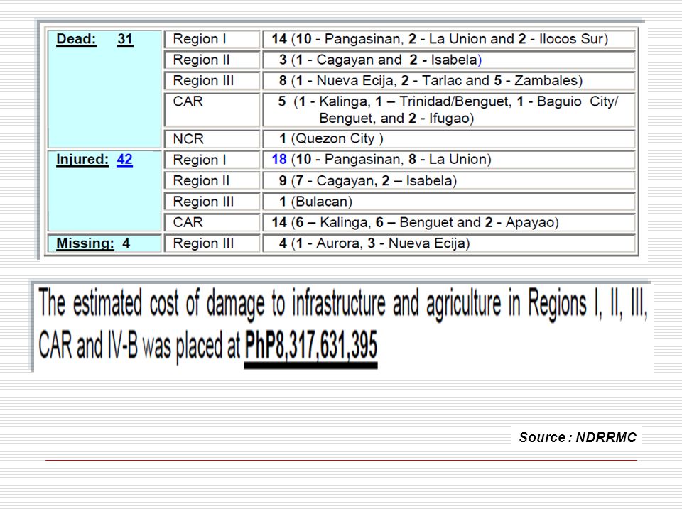
Source : NDRRMC

21
2010 TROPICAL CYCLONES TC Intensity: TY / TS / TD 0001 > AGATON / TS / 2010 / 032400 to 032700 0002 > BASYANG / TY / 2010 / 071118 to 071418 0003 > CALOY / TS / 2010 / 071818 to 071918 0004 > DOMENG / TS / 2010 / 080306 to 080506 0005 > ESTER / TS / 2010 / 080612 to 080900 0006 > FLORITA / TD / 2010 / 082706 to 082806 0007 > GLENDA / TY / 2010 / 082906 to 083100 0008 > HENRY / TS / 2010 / 090218 to 090406 0009 > INDAY / TY / 2010 / 091500 to 091912 0010 > JUAN / TY / 2010 / 101506 to 102018 0011 > KATRING / TS / 2010 / 102308 to ________ 2010 Actual Tropical Cyclone Tracks

22
MARAMING SALAMAT PO! PAGASA-DOST website: http://www.pagasa.dost.gov.ph/ Tracking the sky.... Helping the Country...

23
NOAA NCEP/NCAR Reanalysis (1968- 1998 climatology)
")
24
NOAA NCEP/NCAR Reanalysis (1968-1996 climatology)
")
25
PAST LA NIÑA EVENTS & IMPACTS ON PHILIPPINE RAINFALL JUNE JULY AUG SEP -2.1-1.1-1.3-2.0-1.9-1.4 ONI 1954196419701973198820072010

Similar presentations


 Science Garden, Agham Rd.,>")

 Prepared by: Climate Monitoring and Prediction Section (CLIMPS) CLIMATOLOGY.>")


>")


 Winter Weather Forecast Conference OMSI / Oregon Chapter of the AMS 29 October 2011 Winter Weather Forecast Conference OMSI.>")

 Ernesto R. Verceles PAGASA 01 December 2005.>")

 Ernesto R. Verceles PAGASA.>")


