Download presentation
Presentation is loading. Please wait.

1
Quality control of biodiversity data: tools & techniques Leen Vandepitte On behalf of WoRMS, EurOBIS & LifeWatch data management teams

3
What needs to be checked?

4
LifeWatch: home for a multitude of web services Part of European Strategy Forum on Research Infrastructures (ESFRI) Distributed virtual laboratory: – Biodiversity research – Climatological & environmental impact studies – Support development of ecosystem services – Provide information for policy makers – Biodiversity observatories, databases, web services and modelling tools – Integration of existing systems, upgrades, new systems LifeWatch wants – Standardization of species data – Integration of distributed biodiversity data repositories & operating facilities LifeWatch needs – Species information services
 Distributed virtual laboratory: – Biodiversity research – Climatological & environmental impact studies – Support development of ecosystem services – Provide information for policy makers – Biodiversity observatories, databases, web services and modelling tools – Integration of existing systems, upgrades, new systems LifeWatch wants – Standardization of species data – Integration of distributed biodiversity data repositories & operating facilities LifeWatch needs – Species information services")
5
LifeWatch offers compilation and combination of several web services These services = taxonomic backbone – Taxonomy access services – Taxonomic editing environment – Species occurrence services – Catalogue services LifeWatch infrastucture: – Identify, analyze and design online data services, models and applications – Make use of all LifeWatch data – = interactive part of LifeWatch

6
LifeWatch web services Login / password required System keeps track of all your “jobs”

7
Taxonomic QC

8
All quality checks relevant for OBIS in one: OBIS data format validation Are mandatory fields available? Is data/information in the mandatory fields available? Plotting of coordinates on map => identifies land versus sea points Validation of the dates (=check format) Taxon match, based on World Register of Marine Species (WoRMS)
 Taxon match, based on World Register of Marine Species (WoRMS).")
9
Data validations and QC services – Check OBIS file

10
NEXT

13
Use this report as feedback to your provider

14
Taxonomic quality control Taxon match: World Register of Marine Species (WoRMS) Taxon match: LifeWatch taxon match: – World Register of Marine Species – Integrated Taxonomic Information System (ITIS) – Catalogue of Life (CoL) – International Plant Name Index (IPNI) – Index Fungorum (IF) – PalaeoBiology Database (Palaeo-DB) – Pan-European Species Infrastructure (PESI)
 Taxon match: LifeWatch taxon match: – World Register of Marine Species – Integrated Taxonomic Information System (ITIS) – Catalogue of Life (CoL) – International Plant Name Index (IPNI) – Index Fungorum (IF) – PalaeoBiology Database (Palaeo-DB) – Pan-European Species Infrastructure (PESI)")
15
WoRMS Taxon Match Tool Freely available, no password/login required This tool uses the following components: TAXAMATCH fuzzy matching algorithm by Tony Rees PHP/MySql port of TAXAMATCH by Michael Giddens Scientific Names Parser by Dmitry Mozzherin

16
Prepare your own file (Plain text [TXT], Comma Separated [CSV] & Excel Sheet [XLS, XLSX] For convenience => colum “scientific_name” Upload onto website
![ Prepare your own file (Plain text [TXT], Comma Separated [CSV] & Excel Sheet [XLS, XLSX] For convenience => colum scientific_name Upload onto website](http://images.slideplayer.com/35/10377004/slides/slide_16.jpg " Prepare your own file (Plain text [TXT], Comma Separated [CSV] & Excel Sheet [XLS, XLSX] For convenience => colum scientific_name Upload onto website")
19
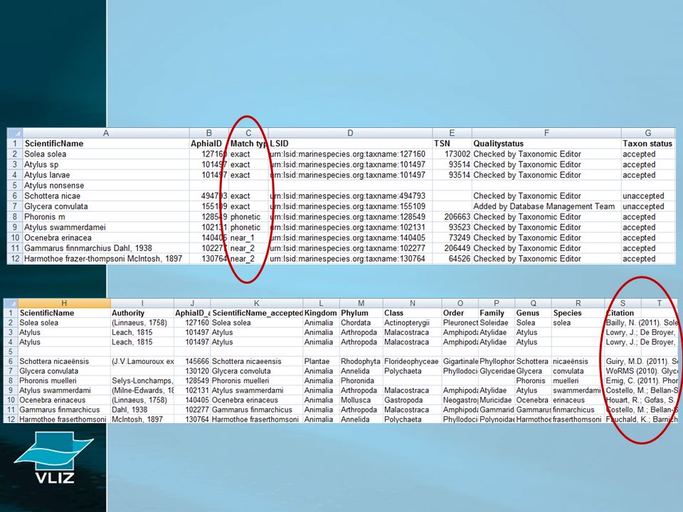
WoRMS taxon match results: – Exact match – Phonetic match – Near_1 match – Near_2 match – No match Check and verify everything that is not an exact match… Some examples: – Phonetic: Fragilaria aurivillii => Fragilaria aurivilii – Near_1: Chaetoceros seychellarum => Chaetoceros seychellarus – Near_2: Gammarus finnmarchius => Gammarus finmarchicus Syllis armoricanus => Syllis armoricana

20
LifeWatch taxon match tool

21
Currently available taxon services If a taxon is not in WoRMS: - Send email to info@marinespecies.orginfo@marinespecies.org - Let us know if it is available in any of the other registers

23
Use this report as feedback to your provider / WoRMS

24
Geographic quality control ? LifeWatch: Show on map LifeWatch: Marine Regions Gazetteer services – Get lat-lon by MrgID – Get lat-lon by name – Get Gazetteer name by lat-lon – Get lat-lon by accepted name

25
Geographic QC – the concept Before quality controlAfter quality control 18°30’25’’N – 5°15’E18.51 ; 5.25 54,23N – 16.5S54.23 ; -16.5 Communication with provider WGS84 = World Geodetic System 1984; most used geographical reference system Decimal degrees => easy to work with

26
Coordinates are indispensable Coordinates = basis of a biogeographic information system When no coordinates are provided… Check with the data provider / the source When existing: complete the file & run QC When not existing: – Derive from provided map – Check Marine Regions to assign coordinates

27
Marine Regions = Standard, relational list of geographic names Coupled with information and maps of the geographic location Improve access and clarity of the different geographic, mainly marine names such as seas, sandbanks, ridges and bays http://www.marineregions.org

28
Fish species “A” present in Kenya Marine species on land? Link with adjacent sea area: EEZ Indicate precision!!!!

31
“Monitoring in Kongsfjorden area” “Monitoring in Belgian part of the North Sea” Latitude & longitude switched “+” & “-” signs switched Some examples The importance of geographical QC

32
Left: coordinates as received; right: corrected. Errors due to missing minus sign Sightings and strandings of marine turtles around the coast of UK and Ireland

33
What else to check…? Use common sense…

34
Dates OBIS data format check includes check on the date format: – Year: “1972” vs “72” vs “972” – Month: between 1-12 – Day: between 1-31, check takes into account the given month but… – Dataset from 1990, with a few records in 1909…

35
Units OBIS can capture: – Counts – Biomass – Depth Are units defined? – Counts: individuals per m², cm², liter, m³ – Biomass: wet weight, dry weight, ash-free dry weight – Depth: meter, centimeter Significance – Needs thorough documenting – Know what you are dealing with – Comparison – Convert to OBIS standards depth: in meter, positive values Abundance: NULL versus 0, positive values

36
Questions?

Similar presentations


 World Register of Marine Species and Aphia IT platform Ward Appeltans>")


