Download presentation
Presentation is loading. Please wait.

1
Make sure you have the following written in your calender: M – WB p 243-245 T – WB p. 250-252 W – Reading Weather Map Practice T- Predicting Weather Practice QUIZ: Chapter 18 terms on THURSDAY!! BELL WORK:

3
Air Mass A huge body of air that has similar temperature, humidity, and air pressure at any given height Classified based on _________and __________. Temperature Humidity Types of Air Masses in North America 1. Maritime Tropical 2. Continental Tropical 3. Maritime Polar 4. Continental Polar AIR MASSES

4
Temperature of Region: Tropical Warm Air from tropics Low Air Pressure Polar Cold Air from Poles High Air Pressure Moisture of the Region: Maritime Air from over the Oceans Very Humid Air Continental Air from over the Land Dry Air Characteristics of the air mass depend on___ & ___ the air mass passes over as it forms. Temperature of region & Moisture of the region

5
Warm, humid air formed over tropical oceans In summer: Bring hot, humid weather In winter: Bring heavy rain or snow If forms over Gulf of Mexico or Atlantic Ocean: Moves 1 st to SE United States move N/NE and influence weather in the central & eastern US If forms over the Pacific Ocean(west): Crosses the coastal mountain ranges and lose moisture MARITIME TROPICAL
: Crosses the coastal mountain ranges and lose moisture MARITIME TROPICAL")
6
Cold, humid air Formed over the icy North Pacific and North Atlantic Oceans In Summer & Winter: Bring fog, rain, cool temps to the west coast MARITIME POLAR

7
Hot, Dry air mass Form mostly in summer over dry areas in the Southwest and Northern Mexico Covers smaller area than other air masses Move Northeast bring hot, dry weather to southern Great Plains CONTINENTAL TROPICAL

8
Form over central and northern Canada & Alaska Form near Artic Circle: Bitterly cold with very low humidity In Winter: Brings clear, cold, dry air to much of North America In Summer: Air Mass is milder Storms may occur if continental polar air moves south to collide with maritime tropical air moving north CONTINENTAL POLAR

9
Weather Changes when air mass moves and interacts with other air masses. In the U.S., air masses are commonly moved by: 1. Prevailing Westerlies Major wind belts over U.S Push air masses from west to east 2. Jet Stream Bands of high-speed wind Blow from west to east & carry air mass in the same directions HOW AIR MASSES MOVE

10
As air masses move over land & oceans: They collide Do NOT easily MIX Less dense goes up/over the more dense air mass Front Boundary where air masses meet Storms and changeable weather develop here 4 Main Types of Fronts: 1. Cold Front 2. Warm Front 3. Stationary Front 4. Occluded Front FRONTS

11
A rapidly moving cold air mass runs into a slow moving warm air mass Denser cold air slides under the lighter warm air Warm air is pushed up at the edge of the colder air Expands & cools; reaches the dew point & clouds form If a lot of water vapor in air = heavy rain/snow If little water vapor in air = cloudy skies Move quickly abrupt weather changes After cold front passes, it leaves behind: colder drier air with clear skies shift in wind lower temperatures COLD FRONT

12
When a fast-moving warm air mass overtakes a slowly moving cold air mass Accompanied by Clouds and precipitation Due to density, the warm air moves over the cold air If warm air is humid light rain or snow falls If warm air is dry dry, scattered clouds form Warm air moves slowly = rainy or cloudy weather for several days After warm front passes, weather will be warm and humid WARM FRONTS

13
When cold and warm air masses meet BUT neither one can move the other Water vapor in the warm air condenses into rain, snow, fog, or clouds Could last for many days STATIONARY FRONT

14
When a warm air mass is caught between two cooler air masses Denser cool air masses move UNDER the less dense warm air mass & push it UP Two cool air masses meet & mix & ground Temperature becomes cooler Warm air mass cut off (occluded) from the ground As it cools, water vapor condenses Weather may turn cloudy & rain OR snow may fall OCCLUDED FRONT
 from the ground As it cools, water vapor condenses Weather may turn cloudy & rain OR snow may fall OCCLUDED FRONT")
15
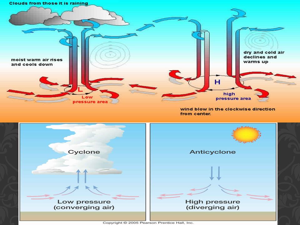
Both form when boundary between two fronts becomes distorted and bends develop along the front Creates either a: 1. Low - Pressure Center 2. High - Pressure Center Cyclones Swirling center of LOW air pressure Winds spin INWARD Cyclones & decreasing air pressure cause: Clouds Wind Precipitation Anticyclones Swirling center of HIGH air pressure Winds spiral OUTWARD Descending air inside causes: Dry, clear weather CYCLONES VS ANTICYCLONES

17
Meteorologist Scientists who study the causes of weather and try to predict it Use maps, charts, and computers to analyze weather data and to prepare weather forecasts Where do they get their information? From National Weather Service Weather Technology used by National Weather Service Weather Balloons Upper troposphere and lower stratosphere Measure temperature, air pressure, & humidity Weather Satellites In the Exosphere Use cameras to WEATHER FORECASTING

18
FORMATION REGIONS

19
TYPICAL PATHS

Similar presentations


 Changes in weather are caused by movements of air masses As an air mass moves away, temp & humidity.>")


