Download presentation
Presentation is loading. Please wait.

1
GEO 3116: REGIONAL DEVELOPMENT GEOGRAPHY OF AMERICA Lecture notes

2
INTRODUCTION ■ America usually refers to either ■ The Americas, a landmass comprising North and South America ■ The United States, a country in North America ■ The terminology of the America’s is complex, but “Anglo-America" can describe Canada and the U.S., while ‘Latin America" comprises Mexico and the countries of Central America and the Caribbean, as well as the entire continent of South America. ■ South and North America are sometimes considered a single continent or supercontinent, while constituent regions are infrequently considered sub continents.

3
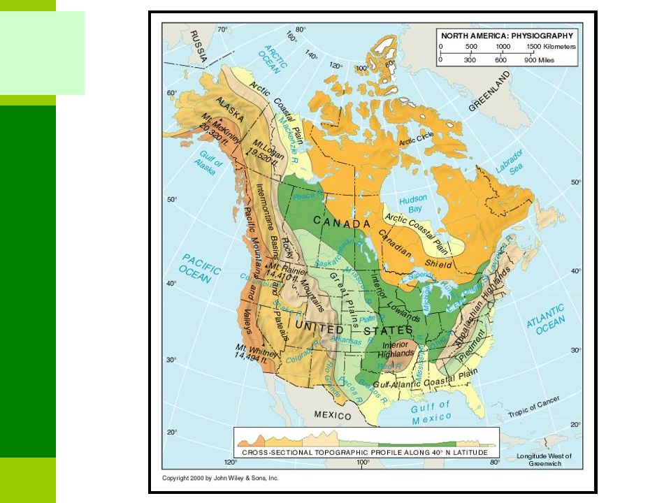
The northern half of America is sparsely populated and covered mostly by Canada, except for the northwestern portion which is occupied by Alaska, the largest state of the U.S.Alaska The central and southern portions are represented by the United States, Mexico, and numerous smaller states primarily in Central America and in the Caribbean. North America is delimited from South America on the southeast by most geographers at the Darien Watershed along the Colombia-Panama border, placing all of Panama within North America. Alternatively, a less common view would end North America at the man-made Panama Canal. Islands generally associated with North America include Greenland, the world's largest island, and archipelagos and islands in the Caribbean.

4
South America is generally considered a continent forming the southern portion of the American landmass, south and east of the Panama-Colombia border, or south and east of the Panama Canal by other scholars.continent Geopolitically and geographically, all of Panama— including the segment east of the Panama Canal in the isthmus—is generally considered a part of North America alone and among the countries of Central America. South America became attached to North America only recently (geologically speaking) with the formation of the Isthmus of Panama some 3 million years ago, which resulted in the Great American Interchange.
 with the formation of the Isthmus of Panama some 3 million years ago, which resulted in the Great American Interchange..")
5
1. http://en.wikipedia.org/wiki/North_America http://en.wikipedia.org/wiki/North_America 1. List of 23 countries in North America

9
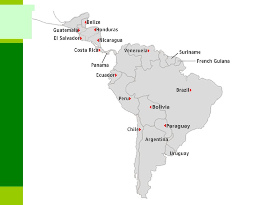
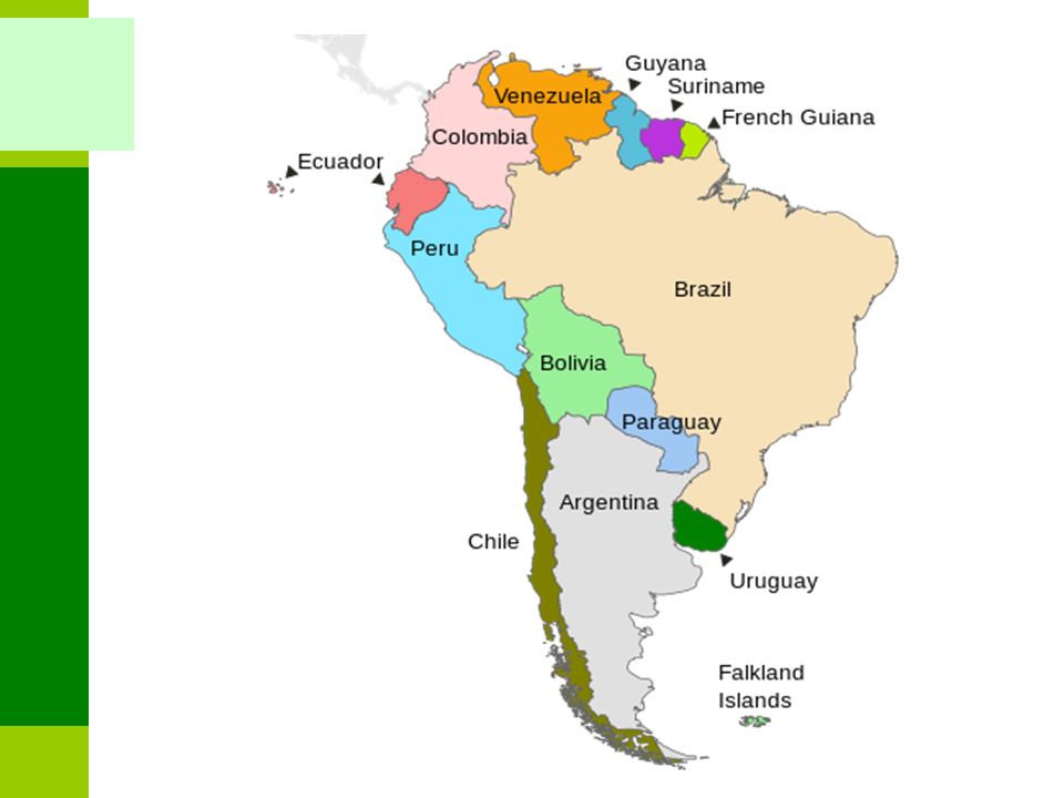
Regions of Middle America Mexico Central America Greater Antilles Lesser Antilles Panama Costa Rica Nicaragua Honduras Guatemala El Salvador Belize Cuba Haiti Dominican Republic Jamaica Puerto Rico Caribbean Sea Atlantic Ocean Pacific Ocean

11
1. http://en.wikipedia.org/wiki/List_of_sovereign _states_and_dependent_territories_in_South _America http://en.wikipedia.org/wiki/List_of_sovereign _states_and_dependent_territories_in_South _America 2. http://en.wikipedia.org/wiki/North_America http://en.wikipedia.org/wiki/North_America

12
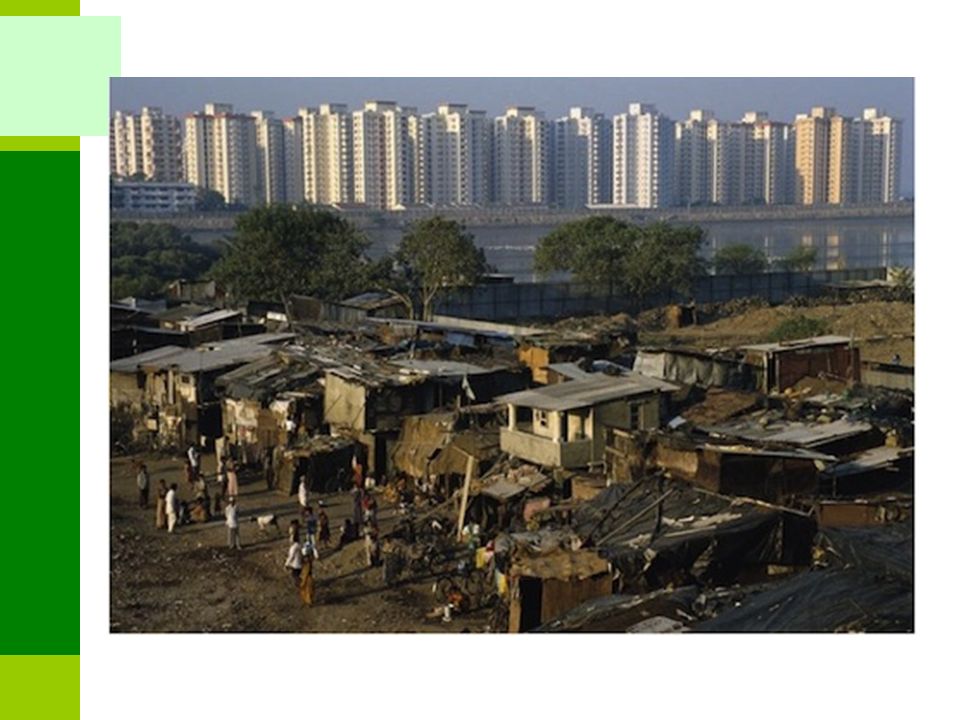
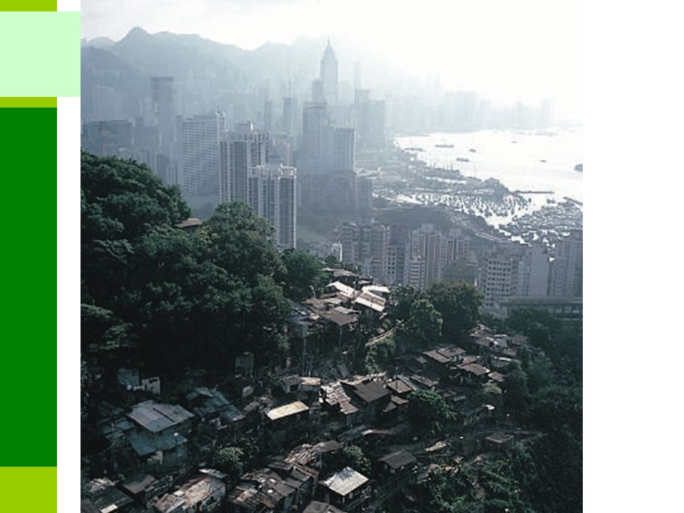
America is a very diverse region, the nations of America are marked by similarly profound contradictions and inequalities – in both physical and socio-economic aspects: With vast extremes of wealth and poverty; Skyscrapers and sprawling shantytowns; Magnificent rainforests and degraded pastures; Lucrative agro-exports and toxic agro- industrial working conditions; Bountiful supermarkets and widespread hunger; Stunning resorts and steaming sweatshops; and Violence and resilience over centuries of uneven development.

13
■ The diversity found in the two continents together with the manifestations of contradictions in America can be looked at in terms of: ■ Geology and Landscape ■ Drainage, watersheds and relief ■ Vegetation patterns ■ Climate ■ Soils ■ Level of urbanization ■ Level of economic development ■ Political organization and development ■ Colonial influence and organization ■ Culture – ways of life/activities engaged in ■ Language ■ Economic systems ■ Level of resource endowment ■ Population size ■ Race ■ Natural disasters!!!

14
Look at the physical diversity and contradictions of America at the following addresses: 1.http://en.wikipedia.org/wiki/Geography_of_ North_Americahttp://en.wikipedia.org/wiki/Geography_of_ North_America 2.http://en.wikipedia.org/wiki/Geography_of_ South_Americahttp://en.wikipedia.org/wiki/Geography_of_ South_America 3.http://ss9geography.wikispaces.com/ - Look at the diversity of the North American continenthttp://ss9geography.wikispaces.com/ 4.http://alta_yes.tripod.com/geographytourism /id23.htmlhttp://alta_yes.tripod.com/geographytourism /id23.html Look at the document uploaded on the platform Physical Geography of America

16
Amazonian Basin Andes Pampas Brazilian Highlands

17
Precipitation in North America Hot & Dry Hot & Wet Cold Precipitation Temperature

18
America and urbanization The city is the most fashionable place to live The Industrial Revolution of the 19th and 20th centuries transformed urban life and gave people higher expectations for improving their standard of living. The increased number of jobs, along with technological innovations in transportation and housing construction, encouraged migration to cities. Development of railroads, streetcars, and trolleys in the 19th century enabled city boundaries to expand. People no longer had to live within walking distance of their jobs. Cities grew in population and expanded geographically by absorbing nearby communities.

21
GEOG 3316– Regional Development Geography of America

22
High rise housing used to re-house shanty dwellers.

23
Migrants

26
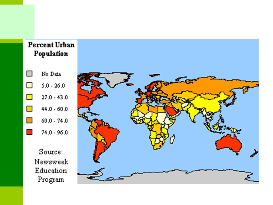
Growing and Shrinking cities in America!! – Look at Facts about Urbanization in America at http://www.wri.org/publication/content/8840 http://www.wri.org/publication/content/8840 South America is characterized by widespread rural-to-urban migration resulting in continued urban growth. This is one of the measures of economic development that ranks South America as more developed than the other developing realms Latin American cities differ from North American cities in their spatial organization (lacity). A central square usually contains governmental buildings and a cathedral at the center of the city. It also contains commercial activity supported by retail and other business establishments
. A central square usually contains governmental buildings and a cathedral at the center of the city. It also contains commercial activity supported by retail and other business establishments.")
27
Explore the following addresses Size of the urban population in each country varies - https://www.cia.gov/library/publications/the- world-factbook/fields/2212.html https://www.cia.gov/library/publications/the- world-factbook/fields/2212.html Number of people living in urban centres - http://en.wikipedia.org/wiki/Urbanization_by _country http://en.wikipedia.org/wiki/Urbanization_by _country Urbanization BBC at http://news.bbc.co.uk/2/hi/in_depth/world/ 2006/urbanisation/default.stm http://news.bbc.co.uk/2/hi/in_depth/world/ 2006/urbanisation/default.stm http://news.bbc.co.uk/2/shared/spl/hi/worl d/06/urbanisation/html/urbanisation.stm

28
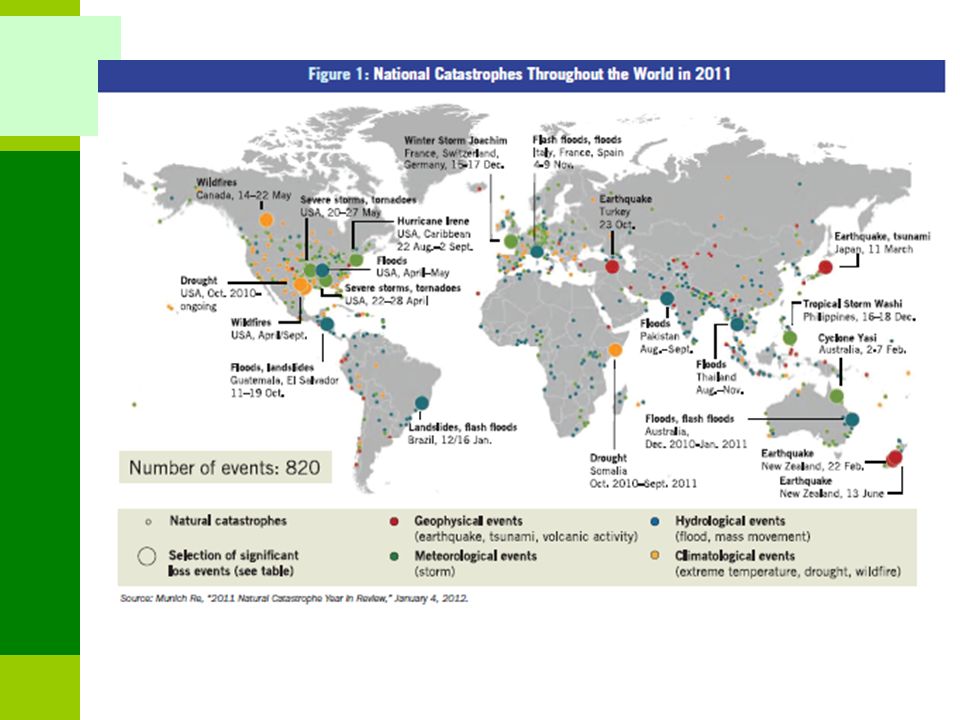
Natural Disasters One of the most dramatic geographical characteristics of America is the natural disasters that periodically strike the region. Although the volcanic mountains that run from Guatemala through Panama are very scenic, they can also be devastating when they erupt. Historically, these volcanic eruptions have wreaked havoc on each of the American countries. Hurricanes and the resulting floods affect the lowlands. Several hurricanes such as Mitch, Katrina devastated America, leaving thousands dead and even more homeless. Earthquakes, like the one in Haiti, Managua, Nicaragua in are just one more natural disaster that affect the region periodically.

31
■ Hurricanes Violent tropical storms. Form during the summer and early fall. About 96 tropical cyclones are reported annually. Spiral shape and curved paths: Caused by the Coriolis effect. Formed 5 degrees north and south of the equator. In the north, storms follow clockwise paths. In the south, storms follow a counterclockwise path. Heat is the critical factor in the formation of tropical storms.

32
World Hurricane Tracks

33
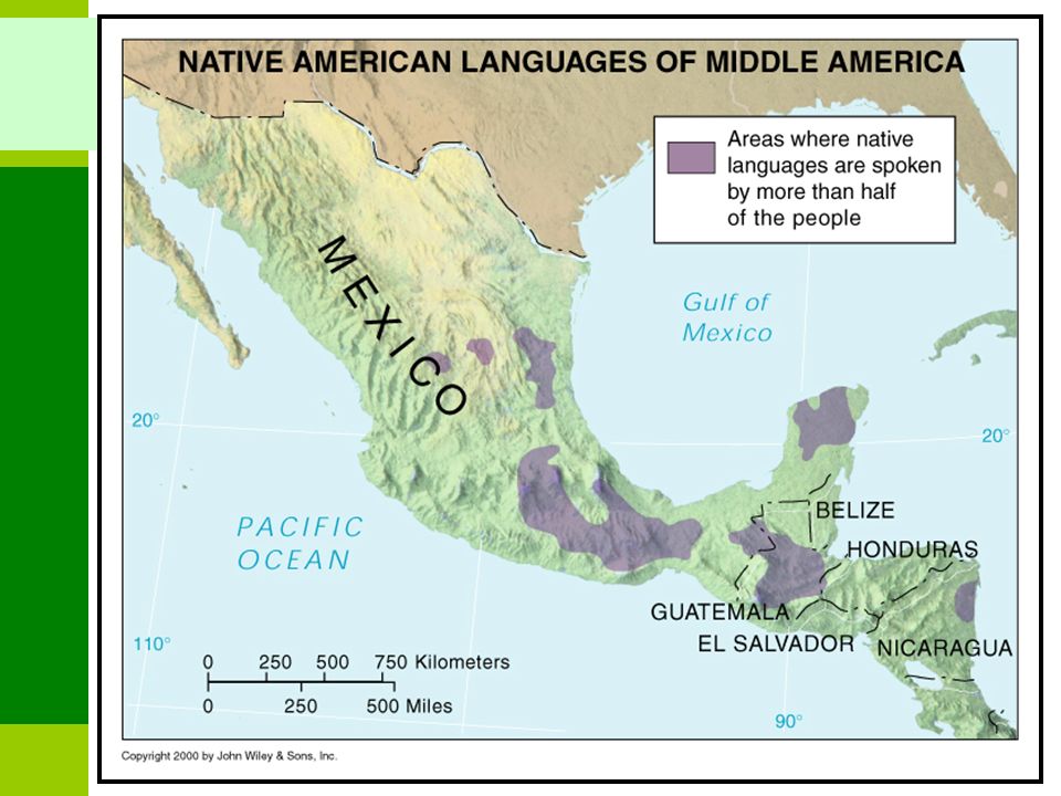
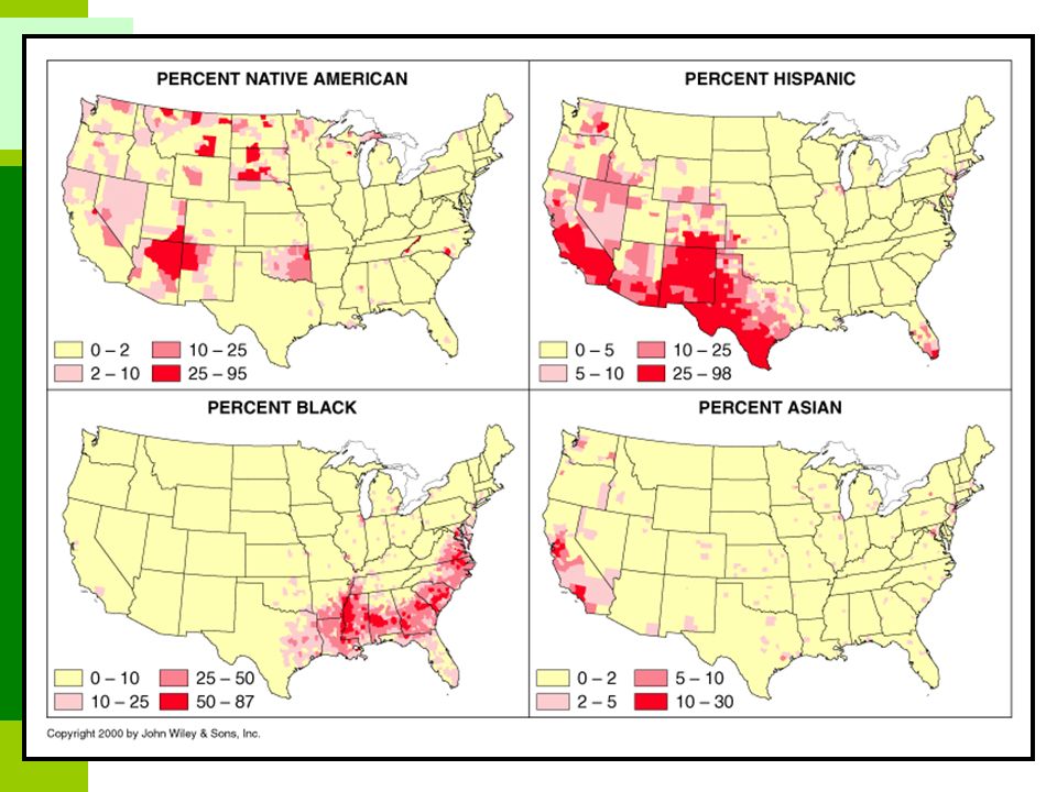
Languages spoken in America

35
Euro-Indian influence. Greater isolation. Hacienda prevailed. Euro-African influence. High accessibility (trade). Plantation economy (Sugar and banana).
. Plantation economy (Sugar and banana)..")
36
Cultural Organisation and Development ■ The Anglo-American cultural space Prominence of English institutions. Opposed to Latin America (Spanish and Portuguese cultural origin). A few exceptions: French Canada, Hawaii, US/Mexico border regions, southeast Florida, First Nations and the Black population. Immigration is changing this space. English remains the language of power and business.
. A few exceptions: French Canada, Hawaii, US/Mexico border regions, southeast Florida, First Nations and the Black population. Immigration is changing this space. English remains the language of power and business..")
37
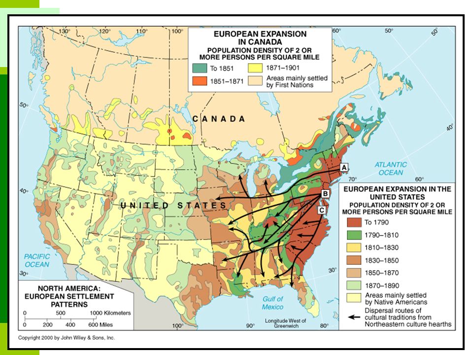
Colonization and Exploration Took 125 years after its discovery for continent to be first settled. Spain and Portugal, the main colonial powers, were more interested in Central and South America. Later England, France and Spain settled North America. Processes of territorial development Annexing new territories. Conquering territories from other colonial empires. Exterminating and repelling First Nations. Three major phases: The colonial era (1492-1783). Independence and expansion (1783-1898). Imperialism (1898-).
. Independence and expansion ( ). Imperialism (1898-)..")
38
■ Colonization of the North American Territory Colonized by four major colonial powers. Spain: Occupied the south of the United States, including Florida, California, Arizona, New Mexico and Texas. Part of the Spanish Empire of Mexico. Massive organization of the native labor. France: Controlled the St. Lawrence, the Great Lakes and the Mississippi basin. More interested in fur trade than in colonization. England: Occupied the Atlantic Coast with 13 colonies (1620 and 1681). Strong emphasis on agriculture and economic development. High population densities constrained by the Appalachians. Holland: Bought Manhattan Island (New Amsterdam) for $24 (1626). Conquered by the British and renamed New York (1664).
. Strong emphasis on agriculture and economic development. High population densities constrained by the Appalachians. Holland: Bought Manhattan Island (New Amsterdam) for $24 (1626). Conquered by the British and renamed New York (1664)..")
39
North America, 1750

42
■ Five major core colonial regions New England: Limited agricultural potential compensated by fishing and logging. Hydraulic power (grain and saw mills). Boston was the main commercial centre. The Middle Colonies: More liberal with Pennsylvania and Delaware as main colonies (initial utopias). New York and Philadelphia were main centers. Southern Colonies: Predominantly rural. Plantation system with slave labor.
. Boston was the main commercial centre. The Middle Colonies: More liberal with Pennsylvania and Delaware as main colonies (initial utopias). New York and Philadelphia were main centers. Southern Colonies: Predominantly rural. Plantation system with slave labor..")
43
Nouvelle France (New France): Centered along the St. Lawrence. Quebec and Montreal as major cities. Focus of fur trade. Limited agriculture. Mexico: Mines and plantations. Natives incorporated in colonial exploitation.

44
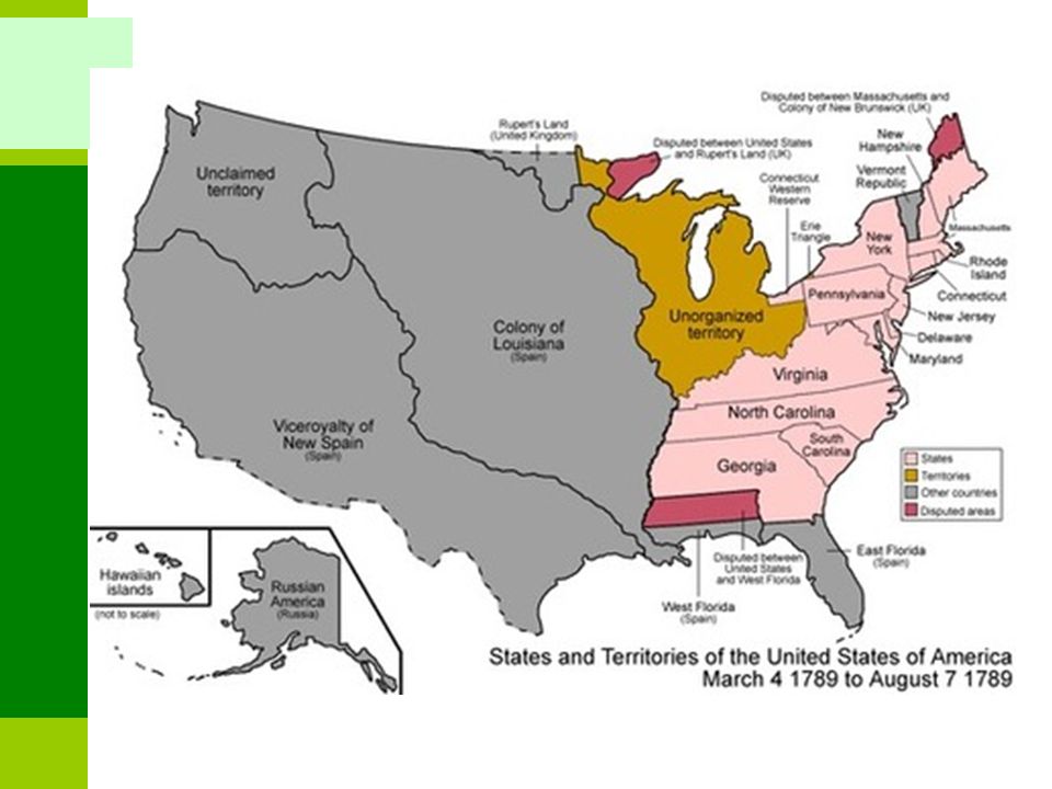
The First 13 Colonies, 1790 1 2 3 4 5 6 7 8 9 10 11 12 13 1 New Hampshire 2 New York 3 Pennsylvania 4 Massachusetts 5 Rhode Island 6 Connecticut 7 New Jersey 8 Delaware 9 Maryland 10 Virginia 11 North Carolina 12 South Carolina 13 Georgia Cumberland passage Fall Line Mason-Dixon Line New England Middle Colonies Southern Colonies

45
■ Religion and colonialism in South America Major concern of the Europeans, especially of the Spanish. Reconquista (1492): Driving the last of the Moors from Spain. Religious struggle as well as a nationalist one. Religious fervor carried over into colonial activity as well. Combination of religious activity with colonial expansion. Religious conversion to Catholicism: Occurred on a massive scale. Religious infrastructure was among the early priorities of the colonial powers: churches, convents, cathedrals. Presence of the Church is felt virtually everywhere in Latin America today. Catholicism mixed with indigenous religions: Unique blend that carries a very strong stamp of the local culture. Catholicism's plethora of saints and myths: Served to make the conversion process itself go more smoothly.
: Driving the last of the Moors from Spain. Religious struggle as well as a nationalist one. Religious fervor carried over into colonial activity as well. Combination of religious activity with colonial expansion. Religious conversion to Catholicism: Occurred on a massive scale. Religious infrastructure was among the early priorities of the colonial powers: churches, convents, cathedrals. Presence of the Church is felt virtually everywhere in Latin America today. Catholicism mixed with indigenous religions: Unique blend that carries a very strong stamp of the local culture. Catholicism s plethora of saints and myths: Served to make the conversion process itself go more smoothly..")
46
■ Iberian invasion Pizzarro overthrew the Inca empire in 1533. Process of land alienation and forced labor. Lima: Coastal city. Capital of the Viceroyalty of Peru. Became one of the richest cities in the world. Viceroyalties of La Plana and New Grenada. Urbanization along the coast. Portugal took the eastern part of the Tordesillas line (Brazil).
..")
47
■ Social and racial stratification Development of a socially stratified society along racial lines. Miscegenation: Mixed race resulting between Caucasians and the indigenous population. Miscegenation began very early on during the colonial period. Early migrations from Europe were primarily male migrations. Mestizos (Métis): European / Indian. Mulattos: European / Black. In most cases continued into contemporary times. One of the overriding realities of Latin America. One of the region's greatest problems.
: European / Indian. Mulattos: European / Black. In most cases continued into contemporary times. One of the overriding realities of Latin America. One of the region s greatest problems..")
48
■ Upper class A small group controlling Latin American society. Primarily comprised of people of European extraction. Many of whom are directly descended from the original settlers of the Conquista. Inherited the large landholdings from that era. ■ Middle class Historically very small in Latin America: Growing substantially in the post-WW II period. Comprised of less wealthy Europeans, mestizos and mulattos.

49
■ Lower class Most numerous group in the region. Remnants of unassimilated indigenous populations: Particularly numerous in Guatemala, parts of Mexico (Oaxaca and Chiapas states), Ecuador, Peru, Bolivia, and parts of Brazil, Venezuela, and Paraguay Work in great estates: Often as sharecroppers. Giving a negotiated percentage of their produce to the landowner, keeping the rest for family use or sale. Descendents of African slaves: Imported during the colonial period for their labor. Numerous in much of Brazil, the Dominican Republic, and Cuba; and in some coastal areas of Colombia, Panama, and Mexico.
, Ecuador, Peru, Bolivia, and parts of Brazil, Venezuela, and Paraguay Work in great estates: Often as sharecroppers. Giving a negotiated percentage of their produce to the landowner, keeping the rest for family use or sale. Descendents of African slaves: Imported during the colonial period for their labor. Numerous in much of Brazil, the Dominican Republic, and Cuba; and in some coastal areas of Colombia, Panama, and Mexico..")
50
Tropical plantation Resembles Middle America’s Rimland. Locations, soils, & tropical climates favor plantation crops, especially sugar. Initially relied on African slave labor. European commercial The most “Latin” part of South America. Population of European descent. Includes the Pampas - temperate grasslands. Economically most advanced. Good transportation networks and quality of life. Amerind subsistence Correlates with the former Inca Empire. Feudal socioeconomic structure persists. Includes some of South America’s poorest areas. Subsistence agriculture must contend with difficult environmental challenges (high altitude). Mestizo-transitional Surrounds the Amerindian-subsistence region. A zone of mixture, culturally & agriculturally. Transitional economic connotations. Undifferentiated Sparsely populated. Isolation and lack of change. Development of Amazonia may prompt significant changes.
. Mestizo-transitional Surrounds the Amerindian-subsistence region. A zone of mixture, culturally & agriculturally. Transitional economic connotations. Undifferentiated Sparsely populated. Isolation and lack of change. Development of Amazonia may prompt significant changes..")
52
Political organization ■ Democratic Society in North America ■ Military dominant in Middle and South America Plays a vastly different role than in most democratic societies: Used to ensure internal control. Serves to support the elites and is frequently led by them. Serves as a social mobility vehicle. Military dictatorships: Characterized regional politics since shortly after independence. Authoritarian means of governance that has focused on social control. Demise of military dictators in Chile (1990), Panama (1989), and Paraguay (1989). The region has at least nominally democratic regimes in place throughout, Cuba representing an exceptional case.
, Panama (1989), and Paraguay (1989). The region has at least nominally democratic regimes in place throughout, Cuba representing an exceptional case..")
53
Level of Economic Development Indicators 1.Use of lights at night

54
Poles of the Global Economy Newly Industrializing Developing Underdeveloped Advanced Oil Export / Rent North America Western Europe East Asia Economies

56
As Salvatore Natoli (a leader in geography education) once said, "In our society we unconsciously equate size with importance and even power."
 once said, In our society we unconsciously equate size with importance and even power.")
57
How does the diversity of the American subcontinent influence development?? 1.Difference in levels of development mean lack of a universal opinion and ideas for development 2.Differences in races mean racial alignments in development, social exclusion, segregation, resentment and unequal access to resources and of course power 3.The gun culture, violence, criminal gangs and the drug trade is a result of marginalisation and inequalities 4.This will be a constraint to cultural cohesion, regional integration and the prospects for common markets altogether 5.Differences in geological history means variations in mineralization 6.Differences in soils means variations in agricultural productivity

58
1.In what ways does the physical and socio- economic diversity in America influence economic development patterns in the region? 2.How have independent countries in America seized opportunities arising out of its physical and socio-economic diversity? 3.In what ways have sovereign states in America been able to withstand the vagaries of weather and other natural disasters in contemporary times? 4.In what ways would you consider America a landscape of contradictions and inequality? 5.America is a regions of extreme weather events. Describe the costs and risks of extreme weather events in America and what strategies independent countries have been adopted to adapt and mitigate those risks?

Similar presentations


>")


