Download presentation
Presentation is loading. Please wait.

1
Geographic Regions of Georgia SS8G1 a., b., c., and d.

2
SS8G1 The student will describe Georgia with regard to physical features and location. a. Locate Georgia in relation to region, nation, continent, and hemispheres.

3
What is a sphere? What is a hemisphere?

5
Northern Hemisphere Western Hemisphere

6
Boom! It’s North America.

7
USAUSA

8
Great Job! Georgia is located in the Southeast of the United States.

9
How does Climate effect Georgia?

10
80 50 Because Georgia is located in the Southeast of the United States it has a mild climate. This means that it has cool winters and warm summers.

12
In the Piedmont and Coastal Plains regions the climate is more humid and tropical. This is because this area receives the warm air from the Gulf of Mexico and the Atlantic Ocean.

13
The rainiest region of Georgia is the Blue Ridge Mountain Region. When the warm air from the Atlantic Ocean rises over the mountains and combines with the cold air in the mountainous region it causes rain to fall.

15
How does Georgia’s climate effect: Tourism Travel Population Industry

16
1. In what hemisphere would you find Georgia? 2. What Continent do we live on? 3. In which country is Georgia a part of? 4. In what region is Georgia Located 5. What kind of impact does Georgia’s climate have on agriculture?

17
SS8G1 The student will describe Georgia with regard to physical features and location. b. Describe the five geographic regions of Georgia; include the Blue Ridge Mountains, Valley and Ridge, Appalachian Plateau, Piedmont, and Coastal Plain.

18
Atlanta, McDonough, Florida, Alabama, Tennessee, South Carolina, Athens, Disney World, North Carolina, Tanger Outlet Mall, Savannah

19
Compare and Contrast these pictures. What do these pictures tell you about the different geographic regions of Georgia?

20
Geographic Region Precipitation Wetland Barrier Island Continental Shelf Fall Line

21
1. Appalachian Plateau 2. Ridge and Valley 3. Blue Ridge 4. Piedmont 5. Coastal Plain The characteristics of each region make unique contributions to our state.

22
Appalachian Plateau

23
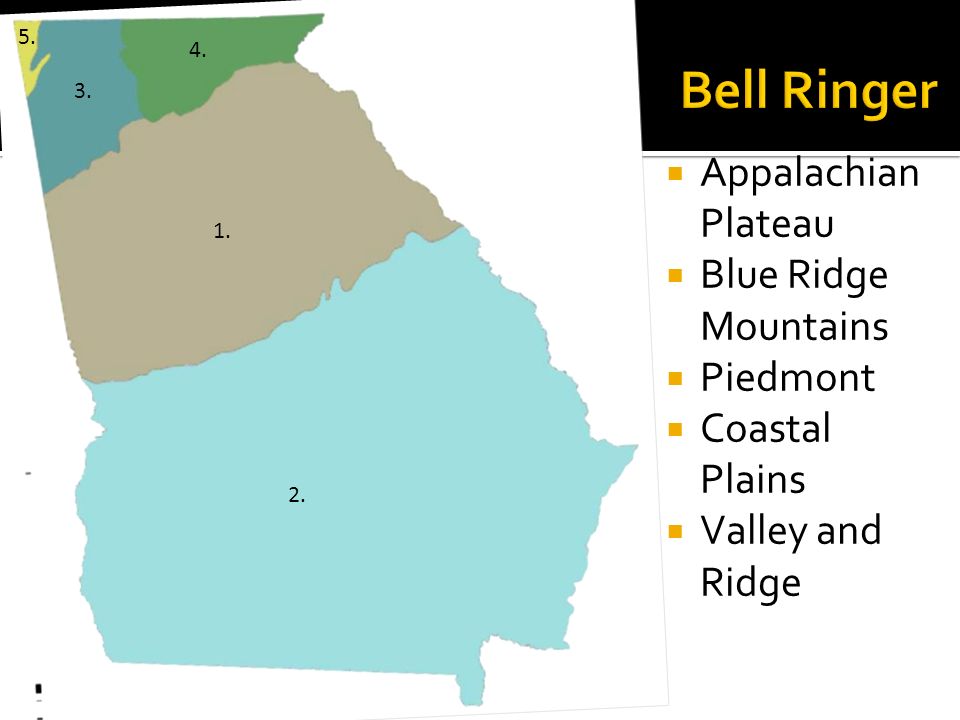
Our smallest geographic region Lookout Mountain, Cloudland Canyon, and Sand Mountain Our only significant coal deposits.

24
Valley and Ridge

25
Lower elevation than Appalachian Plateau Low open valleys and narrow ridges The Ridge and Valley region was covered with water many years ago. Now, when you visit this region, you can find ancient sea fossils of all kinds.

26
Blue Ridge Mountains

27
Highest mts. in the state including Brasstown Bald- Georgia’s highest point. Provides water for the entire state through precipitation from trapping warm moist Gulf air Sandy loam and clay soil good for hardwoods, vegetable farming and apples Beginning of Appalachian Trail, home to Amicalola Falls, Tallulah Gorge, and Helen (See it while you can. Erosion continues to wear down the height of the mountains.)
.")
28
Brasstown Bald: You can see 3 states from this point. Can you name them? Helen, Georgia has a strong German influence. Why do you think that is? How does the town of Helen contribute to our state? Amicalola Falls Ga. Fruits & Vegetables

29
Piedmont

30
Begins in the mountain foothills of N. Georgia and goes to the central part of the state. We are currently in the Piedmont region. Soil is sandy loam and red clay suitable for growing hardwoods, pine, and agriculture. Cotton belt before the Civil War, now wheat, soybeans, corn, poultry, and cattle. Some of the most densely populated cities and crossed by Chattahoochee, Flint, Ocmulgee, and Oconee rivers.

31
Why do you think most of Georgia’s major cities are located in the Piedmont region? Georgia’s Flint River starts in Clayton County. Why do you think most of Georgia’s rivers start in the Piedmont region? Sandy loam and red clay are great for agriculture.

32
Coastal Plains

33
There are two parts to Georgia’s coastal plain: The Inner Coastal Plain The Outer Coastal Plain Which color do you think represents the Inner Coastal Plain and which color represents the Outer Coastal Plain? Why?

34
Good supply of underground water Major agricultural region: Vidalia Onions, peanuts, pecans, and corn

35
The soil here is not good for agriculture Deep harbors and barrier islands also provide for tourism/recreation, fishing industry, and ports for importing/exporting goods. Location of the earliest visits by explorers, first forts for protection, and Georgia’s first settlements.

36
Trees are used to produce pulp. The processed goods are then shipped from our shores. Why do you think a British flag flies over Fort Frederica? Early map of Savannah Our shores continue to bring visitors to our state.

37
STOP

38
1. How does Georgia’s climate effect its agriculture? 2. Which Region were you assigned yesterday? a. List three facts about this region… 3. List the Hemisphere, Continent, Country, and Region in which Georgia is located.

39
Bell Ringer Appalachian Plateau Blue Ridge Mountains Piedmont Coastal Plains Valley and Ridge 1. 2. 3. 4. 5.

40
Which region has the highest population out of the five?

41
Appalachian Plateau Blue Ridge Mountains Piedmont Coastal Plains Valley and Ridge 1. 2. 3. 4. 5.
42
Appalachian Plateau

43
Valley and Ridge

44
Blue Ridge Mountains

45
Piedmont

46
Coastal Plains

47
SS8G1 The student will describe Georgia with regard to physical features and location. c. Locate and evaluate the importance of key physical features on the development of Georgia; include the Fall Line, Okefenokee Swamp, Appalachian Mountains, Chattahoochee and Savannah Rivers, and Barrier Islands.

48
1. Fall Line 2. Okefenokee Swamp 3. Appalachian Mountains 4. Chattahoochee River 5. Savannah River 6. Barrier Islands

49
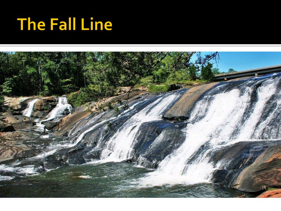
The Fall Line is the boundary between the Piedmont and the Coastal Plains. Many early major cities developed on this line because many rivers flow through them to the Fall Line to the ocean. FALL LINE

51
This area is the state’s highest and wettest location. It attracts many tourists. They usually go to the Brasstown Bald; the highest point in Georgia. Appalachian Mountains

53
These mountains are considered an “endangered vacation spot.” Why would they be termed endangered? These mountains are considered an “endangered vacation spot.” Why would they be termed endangered?

54
Largest swamp in North America. Now this area is protected by the national government because it is a Natural Wildlife Reserve. Okefenokee Swamp

56
The Barrier Islands are made up of several separate islands. These islands help protect Georgia from major Hurricane damage. Barrier Islands

57
There are resorts and fantastic beaches that bring in tourists.

58
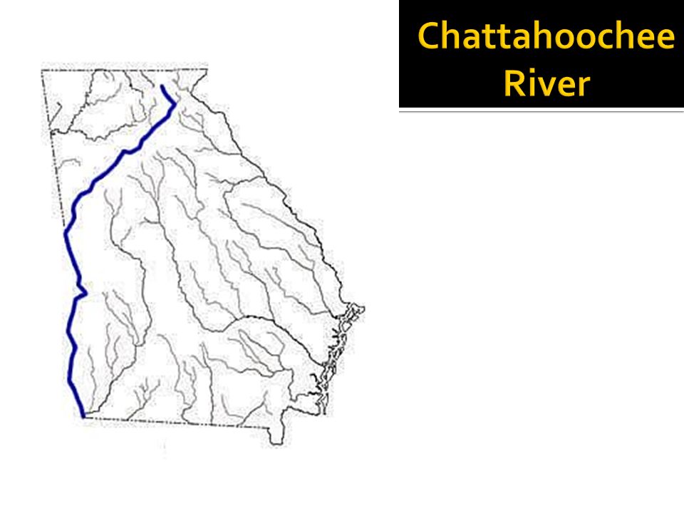
This river is the natural divide between Alabama and Georgia. Chattahoochee River

60
Forms the natural boundary between South Carolina and Georgia. Savannah River

61
One of the busiest ports in the USA.

62
STOP

63
Appalachian Plateau Blue Ridge Mountains Piedmont Coastal Plains Valley and Ridge 1. 2. 3. 4. 5.

64
Savannah River Appalachian Mountains Barrier Islands Fall Line Chattahoochee River b. a. d. c. e. f.

65
Finish Group Assignment Create the Giant Georgia Puzzle Then

66
Define: Erosion, Precipitation, Weather, Climate, Blue Ridge Mountains, Valley and Ridge, Appalachian Plateau, Piedmont, and Coastal Plain. Fall Line, Okefenokee Swamp, Appalachian Mountains, Chattahoochee and Savannah Rivers, and Barrier Islands. Pg. 22; questions #3 and #4 Pg. 26; question #3 Pg. 29; #2 and #3 Pg. 31; #2-4 Pg. 33; #1-2,4-7, and 10

67
Okefenokee Swamp: Covers 681 square miles making it the largest swamp in North America Freshwater wetland (wetland: low-lying land area where water lies close to the surface)
")
68
Salt Marshes: A wetland that is influenced by tides Georgia ranks 4 th in the nation in wetland acres A marsh at low tide. The same marsh at high tide.

69
Barrier islands protect the mainland from wind, sand, and water that cause erosion. Georgia has 18 barrier islands. These islands are tourist destinations but 2/3 of the land remains wilderness sanctuaries.

70
Continental Shelf: Where the land meets the sea The Fall Line: Where hilly land meets the coastal plain Runs from Columbus through Macon to Augusta Prevented exploration but provided for settlements

Similar presentations


>")


:>")


 Step 3: Record During lesson, take notes here to record the details relating to the main idea. Skip lines to end.>")

