Download presentation
Presentation is loading. Please wait.

1
What can cause mountains or hills to form? Are the mountains or hills young or old? What is the role of plate tectonics in shaping the land? Describe the shape of the land.

2
Exposures of folded rocks are rare in Wisconsin, However, they are common in many parts of the world. The next slide shows the area of Eastern Pennsylvania. Folded Rocks? Where and How.

3
Google Earth Map and Google Topo map of Eastern PA, showing the Fold Mountains, folded during Appalachian Mountain Building

4
Location of Chickies Rock and Folded Mountains in Pennsylvania These rocks are also folded

5
The Baraboo Range

7
Exposed, upthrusted ends of the Baraboo Syncline.

8
This rock formation is thought to have been originally formed as sedimentary rock in the Precambrian period – This geologic period spans roughly 4.5 billion to 450 million years ago. That is about 90% of the earth’s existence. It was then metamorphosed, folded and thrust upwards sometime in the Proterozoic age – 1.6 billion years ago. It is among the oldest known exposed rock on the planet.

9
Exposed, upthrusted ends of the Baraboo Syncline.

11
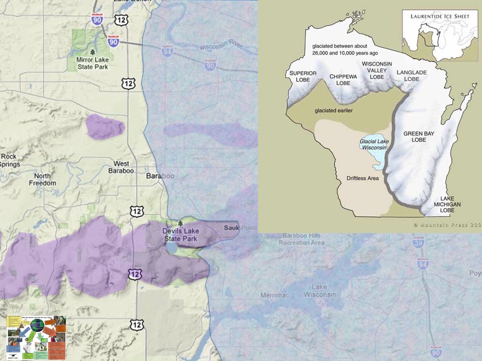
Glacial Landforms and the Baraboo Range

12
Over 60 glacial advances and retreats have occurred during the last 2 million years. The most recent glaciation in North America, called the Wisconsinan is still in effect. It reached its maximum extent roughly 21,000 years ago. It radically altered the terrain of the Midwest region. The edges of the glacier created many unique landforms and altered the landscape dramatically.

13
Glacial Landforms and the Baraboo Range Over 60 glacial advances and retreats have occurred during the last 2 million years. The most recent glaciation in North America, called the Wisconsinan is still in effect. It reached its maximum extent roughly 21,000 years ago. It radically altered the terrain of the Midwest region. The edges of the glacier created many unique landforms and altered the landscape dramatically.

18
Glacial Lake Wisconsin – ca. 21,000 B.P.

20
River Course Changes Due to Wisconsinan Glaciation

21
Before Glaciation Ancient Confluence

22
During Maximum Glaciation

23
After Glaciation Modern Confluence

24
Devil’s Lake Gorge Before Glaciation ca – 800,000 B.P.

25
Devil’s Lake Gorge During Glaciation ca – 21,000 B.P.

26
Devil’s Lake Gorge After Glaciation ca – 6,000 B.P.

27
For the Teacher (landforms) The Baraboo Syncline is a doubly-plunging, tight, asymmetric syncline in the Proterozoic-aged Baraboo Quartzite, in south-central Wisconsin. Approximately 40 kilometers long by 15 kilometers wide, the syncline is strikingly three-dimensional. The northern limb is subvertical to slightly overturned; the eastern termination plunges approximately 35 degrees westward; the southern limb dips around 35 degrees northward; and the western termination plunges approximately 25 degrees eastward. On the southern limb, where quartzite beds are sandwiched within phyllitic layers, three-dimensional pinch-and-swell structures ("chocolate tablet boudinage") show extension parallel to layering, both along strike and down dip. This extension is clearly NOT related to fold curvature, as it is within the straight, long limb of the syncline. Both the fold geometry and the extension within the gently dipping limb of the syncline are suggestive of formation in a non-plane strain, top-to-the-south simple shear environment. In such an environment, non-cylindrical fold trains would verge southward. The longer, north-dipping fold limbs would be favorably oriented for localized layer-parallel extension, while the shorter, steeply dipping limbs would not. Moreover, extension along the fold axis would also be predicted. This model therefore could explain both the strong change in plunge along trend and the three- dimensional boudinage within the southern limb of the Baraboo Syncline
 show extension parallel to layering, both along strike and down dip. This extension is clearly NOT related to fold curvature, as it is within the straight, long limb of the syncline. Both the fold geometry and the extension within the gently dipping limb of the syncline are suggestive of formation in a non-plane strain, top-to-the-south simple shear environment. In such an environment, non-cylindrical fold trains would verge southward. The longer, north-dipping fold limbs would be favorably oriented for localized layer-parallel extension, while the shorter, steeply dipping limbs would not. Moreover, extension along the fold axis would also be predicted. This model therefore could explain both the strong change in plunge along trend and the three- dimensional boudinage within the southern limb of the Baraboo Syncline.")
Similar presentations