Download presentation
Presentation is loading. Please wait.

1
Metadata Michael Moeller NOAA Coastal Services Center Understanding the Value and Importance of Proper Data Documentation

2
Presentation Outline First Things First The What and the Why A Component of Data The Value of Metadata Why Have a Standard? The FGDC Metadata Clearinghouse

3
Metadata First Things First

4
Metadata - Documentation of geospatial data written in a consistent manner Terms Used in This Presentation FGDC - Federal Geographic Data Committee CSDGM - Content Standard for Digital Geospatial Metadata, referred to commonly as “The Standard” or “The Content Standard” Clearinghouse - A distributed catalog of metadata Geospatial - refers to a geographic location

5
Metadata The What and the Why

6
Simply put, metadata is information about data. What is Metadata?

7
This is the metadata for this. What’s Missing?

8
Author(s) Boullosa, Carmen. Title(s) They're cows, we're pigs / by Carmen Boullosa Place New York : Grove Press, 1997. Physical Descr viii, 180 p ; 22 cm. Subject(s) Pirates Caribbean Area Fiction. Format Fiction Author(s) Boullosa, Carmen. Title(s) They're cows, we're pigs / by Carmen Boullosa Place New York : Grove Press, 1997. Physical Descr viii, 180 p ; 22 cm. Subject(s) Pirates Caribbean Area Fiction. Format Fiction This is the metadata for this. While the card-catalog entry is a form of metadata, it does not address topics such as quality, accuracy, or scale. Well-written geospatial metadata describes these and many more aspects of the data.
 They re cows, we re pigs / by Carmen Boullosa Place New York : Grove Press, Physical Descr viii, 180 p ; 22 cm. Subject(s) Pirates Caribbean Area Fiction. Format Fiction Author(s) Boullosa, Carmen. Title(s) They re cows, we re pigs / by Carmen Boullosa Place New York : Grove Press, Physical Descr viii, 180 p ; 22 cm. Subject(s) Pirates Caribbean Area Fiction. Format Fiction This is the metadata for this. While the card-catalog entry is a form of metadata, it does not address topics such as quality, accuracy, or scale. Well-written geospatial metadata describes these and many more aspects of the data..")
9
Identification_Information Citation Citation_Information Originator: NOAA Coastal Services Center Publication_Date: 19971131 Title: Hurricane Storm Surge Geospatial_Data_Presentation_Form: Map Publication_Information Publication_Place: Charleston, SC Publisher: NOAA Coastal Services Center Larger_Work_Citation Citation_Information Identification_Information Citation Citation_Information Originator: NOAA Coastal Services Center Publication_Date: 19971131 Title: Hurricane Storm Surge Geospatial_Data_Presentation_Form: Map Publication_Information Publication_Place: Charleston, SC Publisher: NOAA Coastal Services Center Larger_Work_Citation Citation_Information This is the metadata for this.

10
We often use metadata without even knowing it. What is Metadata?

11
Metadata is information about data. Without a label, how would you know which one to eat and which one to feed to your cat? Cat Food? Tuna? If you had two cans without labels, which would you eat? What is Metadata?

12
Other Examples?

13
Metadata A Component of Data

14
Proper data documentation provides vital information to interested parties. A Component of Data

15
Metadata is that component of data which describes it. Environmental Sensitivity Index Data Metadata RARNUM - unique combination of species, concentration, and seasonality CONC (concentration) = Denisty species is found at location Season_ID = seasonality code like to the seasonal table Element - Biology group A Component of Data
 = Denisty species is found at location Season_ID = seasonality code like to the seasonal table Element - Biology group A Component of Data.")
16
It’s data about a data set. Title Scale Source Content Location Publication Access Title Scale Source Content Location Publication Access MetadataMetadata GIS files Imagery Geospatial databases GPS data GIS files Imagery Geospatial databases GPS data Data set A Component of Data

17
Metadata describes….. Characteristics of the data Characteristics of the data content quality condition who what where why when how A Component of Data

18
Metadata is a critical component of a complete data set. A Component of Data

19
As a component of data, metadata should never be viewed or treated as a separate entity. Take Home Message Metadata is an integral part of any data set. A Component of Data

20
The Value of Metadata Why Bother with Metadata?

21
“It takes a lot less time, and most people won’t notice the difference until it’s too late.” The Value of Metadata

22
Documenting a data set is the key to preserving its usefulness over time. The Value of Metadata

23
Two similar paintings by Picasso sold for vastly different prices. Why? One had metadata......One didn’t. The Value of Metadata

24
Usefulness of Metadata over time The Value of Metadata 1980 2000 Official Snowfall Teheran Tehran Cape Hatteras Light HEW Dept. of Education HHS Germany I-95 I-395 I-495 I-95 British Honduras Belize Mount St. Helen arpanet internet Minor Lane Heights, KY

25
Metadata has value associated with it. The Value of Metadata

26
Avoid duplication Share reliable information Publicize efforts Reduce workload For data developers, metadata... The Value of Metadata

27
Facilitates understanding Focuses on key elements Enables discovery — inside and outside of organizations For data users, metadata... The Value of Metadata

28
For organizations, metadata... The Value of Metadata Protect investments Create an institutional memory Counter personnel changes Allow sharing of data with other agencies Reduce costs Limit potential liability Save time and money

29
Metadata as a “data discovery” tool This saves time and money. The Value of Metadata If it’s geospatial data you need, metadata helps 3Find data of interest 3Determine the usefulness of the data 3Determine how to access the data

30
This “data discovery” is all accomplished through the use of a clearinghouse, an on-line searchable catalog of standardized metadata records. The Value of Metadata

31
Why Have a Standard? Standardized Metadata

32
Why Have a Standard? Think for a moment how hard it would be to…. … bake a cake without standard units of measurement … put gas into your car without standard nozzle sizes … plug a lamp into a socket without standard electrical outlets Standards help ensure a level of consistency. Standardized metadata is no different. The standard for metadata ensures a level of consistency for data documentation.

33
Establishing a Standard Federal agencies and organizations receiving federal funds must document all geospatial data using the FGDC Content Standard for Digital Geospatial Metadata (CSDGM). Executive Order 12906, 1995 The Federal Geographic Data Committee (FGDC) Organized in 1990 under the Office of Management and Budget Promotes the coordinated use, sharing, and dissemination of geospatial data on a national basis Background
 Organized in 1990 under the Office of Management and Budget Promotes the coordinated use, sharing, and dissemination of geospatial data on a national basis Background.")
34
This “Content Standard” serves as a uniform summary description of the data set. Establishing a Standard

35
The Content Standard utilizes... Common terms Common definitions Common language Common structure Access constraints Citation currentness entity attribute domain lineage Process step Establishing a Standard

36
The Content Standard… Establishes names of compound elements and data elements. Defines information about values provided for data elements. Access constraints Citation currentness entity attribute domain lineage Establishing a Standard

37
The Content Standard helps the user determine... If a set of geospatial data is available and fit for a particular use. How to access and transfer the data set. Establishing a Standard

38
Who created and maintains the data? Why were the data created? What is the content and structure of the data? Metadata written using the Content Standard answers these questions: Establishing a Standard

39
Metadata written using the Content Standard answers these questions: When were the data collected? Published? What is the geographic location? Storage location? How were the data produced? Establishing a Standard

40
Determine if a data set meets a particular need Determine which data exist for a geographic location Process and use the data set Acquire the data set of interest Metadata written using the Content Standard includes information to… Establishing a Standard

41
The FGDC Metadata Clearinghouse Metadata as a Data Discovery Tool

42
What’s a clearinghouse, you ask? The FGDC clearinghouse is a decentralized system of servers located on the Internet that contain field-level descriptions of available digital spatial data. The FGDC Metadata Clearinghouse

43
The descriptive information used in the clearinghouse is metadata, which is collected in a standard format to facilitate query and consistent presentation across multiple participating sites. The Clearinghouse and Metadata The FGDC Metadata Clearinghouse

44
To accomplish this, metadata is written according to the “Content Standard for Geospatial Metadata” (CSDGM), developed by the FGDC. This standard provides a common format which allows information about geospatial data to be stored in a searchable database (clearinghouse). The Clearinghouse and Metadata The FGDC Metadata Clearinghouse
. The Clearinghouse and Metadata The FGDC Metadata Clearinghouse.")
45
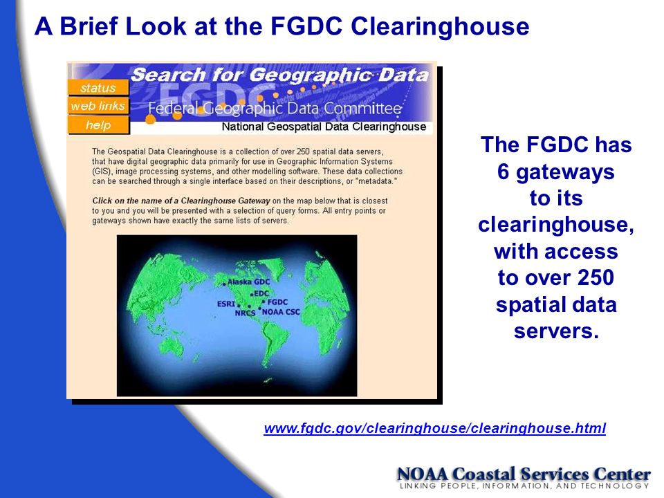
A Brief Look at the FGDC Clearinghouse The FGDC has 6 gateways to its clearinghouse, with access to over 250 spatial data servers. www.fgdc.gov/clearinghouse/clearinghouse.html
46
A Brief Look at the FGDC Clearinghouse Searches can be performed by place names or by using a map interface.

47
The new NSDI Search Wizard bins servers by the types of metadata they house. A Brief Look at the FGDC Clearinghouse

48
Searches can be performed using a map interface that allows the user to define an area of interest. A Brief Look at the FGDC Clearinghouse An area of interest can be defined by dragging an area of interest box on the map interface.

49
The selected area defines the bounding coordinates that will be used in the search. A Brief Look at the FGDC Clearinghouse

50
You can search all the servers listed, or you can select only those that interest you. A Brief Look at the FGDC Clearinghouse

51
Individual servers are selected by holding the Ctrl key down and selecting with the mouse. A Brief Look at the FGDC Clearinghouse

52
Search criteria can be further refined by time period of content and keywords. A Brief Look at the FGDC Clearinghouse

53
The status of each selected node is displayed as search is conducted.

54
A Brief Look at the FGDC Clearinghouse When the search is complete, the status window lets you know if you were successful in discovering metadata that matched your search criteria.

55
A Brief Look at the FGDC Clearinghouse Select a server to see what metadata is available.

56
A Brief Look at the FGDC Clearinghouse Metadata found by the search is displayed by title.

57
A Brief Look at the FGDC Clearinghouse Metadata record returned in HTML format. Links take you to each of the seven main sections of the record.

58
A Brief Look at the FGDC Clearinghouse

59
The Coastal Information Directory (CID) at the NOAA Coastal Services Center is similar to the FGDC gateway interface, but the CID searches only those spatial data servers that house metadata of a coastal nature. www.csc.noaa.gov/CID/ A Brief Look at the FGDC Clearinghouse

60
For more information on the clearinghouse system, visit the FGDC Web site (www.fgdc.gov). Here you can find information on how to establish your own clearinghouse node using free Isite software. On-line tutorials provide assistance for setting up and configuring this software. A Brief Look at the FGDC Clearinghouse

61
Finally... Remember, metadata is a legacy document that concisely sums up your data or data set. Without metadata, your data set is incomplete.

62
Michael Moeller NOAA Coastal Services Center Mike.Moeller@noaa.gov www.csc.noaa.gov/metadata/

Similar presentations


>")


