Download presentation
Presentation is loading. Please wait.

1
From catchment to continental scale: Issues in dealing with hydrological modeling across spatial and temporal scales Dennis P. Lettenmaier Department of Civil and Environmental Engineering University of Washington Seattle, WA for presentation at CAHMDA II Workshop The terrestrial water cycle: Modeling and data assimilation across catchment scales Princeton University October 26, 2004

2
“The motivation behind CAHMDA II is to assess the state-of-the art in observing, explaining, and modeling the terrestrial water cycle and to identify research needs …” “Progress is urgently needed in order to be able to quantify climate-induced changes in the large-scale water cycle”

3
Three problems (“opportunities”, not solutions) Vegetation and land cover change, and issues related to scale Spatial scale effects in the context of macroscale modeling Temporal scale effects relevant to catchment and macroscale modeling (but with a focus on macroscale) Concluding comments – where does data assimilation fit with these three topics?
 Vegetation and land cover change, and issues related to scale Spatial scale effects in the context of macroscale modeling Temporal scale effects relevant to catchment and macroscale modeling (but with a focus on macroscale) Concluding comments – where does data assimilation fit with these three topics")
4
1. Vegetation and land cover change The backdrop: man’s activities have affected the “natural” vegetation over much of the globe, but most hydrologic models don’t represent these effects well, if at all

5
Two models: DHSVM and VIC DHSVM (Distributed Hydrology-Soil-Vegetation Model): Explicitly spatially distributed with respect to topography, downslope redistribution of moisture in saturated zone, spatial distribution of soil and vegetation properties, and topographic effects on downward solar radiation. Typical spatial scale of application: 10-150 m. VIC (Variable Infiltration Capacity) model: Uses parameterization of effect of subgrid variability of soils and topography on surface runoff generation; subgrid variability of vegetation represented via “mosaic” approach. Typical scale of application: 1/8 – 2 degrees latitude by longitude
 model: Uses parameterization of effect of subgrid variability of soils and topography on surface runoff generation; subgrid variability of vegetation represented via mosaic approach. Typical scale of application: 1/8 – 2 degrees latitude by longitude.")
8
Question: What are the effects of vegetation change (e.g. logging, fires) on runoff generation (especially flooding), e.g., in the Pacific Northwest? From Bowling and Lettenmaier, 1997
 on runoff generation (especially flooding), e.g., in the Pacific Northwest. From Bowling and Lettenmaier,")
10
Forest road effect on flood distribution, Deschutes River, WA (roads vs no roads, mature vegetation) From Lamarche and Lettenmaier (1998)
 From Lamarche and Lettenmaier (1998)")
11
Forest harvest effect on flood distribution, Hard and Ware Creeks, WA (mature vs current vegetation, no roads)
")
12
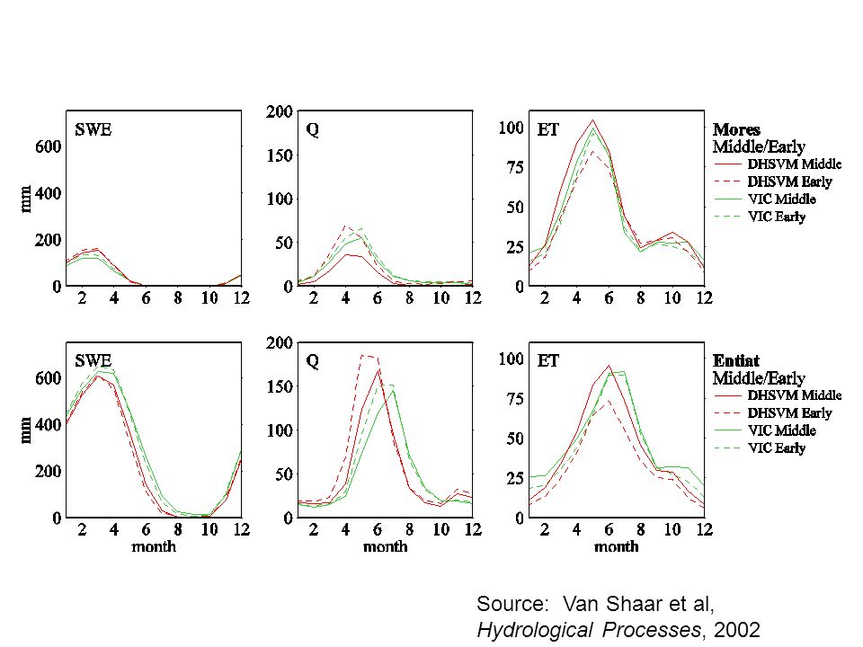
Question: how different are predicted vegetation change sensitivities using a high resolution catchment model (DHSVM) vs macroscale model (VIC)? Some issues: Control for difference in the forcings Both models calibrated locally (vs regional VIC implementation) Control for differences in the vegetation characterizations (as much as possible)
 Control for differences in the vegetation characterizations (as much as possible).")
13
Source: Van Shaar et al, Hydrological Processes, 2002

17
Results: Overall trends in SWE, soil moisture, ET, and runoff are similar between the two models But, the sensitivities are quite different – DHSVM (high resolution saturation excess model) is considerably more sensitive to vegetation change than is VIC (macroscale) Possible reasons include: –Explicit representation of saturated areas in DHSVM (which are areas of high sensitivity) –Differences in handling of fractional vegetation cover (which affect net radiation, and hence snow accumulation, at the surface) – Explicit handling of elevation and aspect in DHSVM
 is considerably more sensitive to vegetation change than is VIC (macroscale) Possible reasons include: –Explicit representation of saturated areas in DHSVM (which are areas of high sensitivity) –Differences in handling of fractional vegetation cover (which affect net radiation, and hence snow accumulation, at the surface) – Explicit handling of elevation and aspect in DHSVM")
18
2. Spatial scale effects in the context of macroscale modeling The backdrop: The spatial scale at which macroscale models are applied often is based on computational considerations, or (in the case of off-line simulations) issues related to the spatial density of the observations from which (often gridded) forcing data are derived. Yet these spatial scale differences can have significant effects on model predictions.
 issues related to the spatial density of the observations from which (often gridded) forcing data are derived. Yet these spatial scale differences can have significant effects on model predictions..")
19
Scale Dependence of Precipitation Variability from Schaake et al, 2004

20
Scale Dependence of Precipitation Variability from Schaake et al, 2004

21
Scale Dependence of Model Response to Precipitation (Surface Runoff) from Schaake et al, 2004
 from Schaake et al, 2004")
22
Scale Dependence of Model Response to Precipitation (Total Runoff) from Schaake et al, 2004
 from Schaake et al, 2004")
23
Columbia and Arkansas-Red River VIC scaling experiments (from Haddeland et al, 2002)
")
24
Effect of spatial scale, spatially uniform precipitation

25
Effect of parameterization for spatial variability of precipitation (black) vs spatially uniform precipitation (open)
 vs spatially uniform precipitation (open)")
26
Effect of elevation bands (open symbols) vs no elevation bands (black symbols) for spatially uniform precipitation
 vs no elevation bands (black symbols) for spatially uniform precipitation")
27
Scale sensitivity of total runoff for Arkansas-Red River basin as a function of water year precipitation

28
3. Temporal scale effects in macroscale modeling The backdrop: Models evaluated at one temporal scale (time step) may perform much differently at another
 may perform much differently at another.")
29
Source: Maurer et al, 2002 VIC long-term monthly streamflow simulations, selected large continental U.S. rivers

30
Source: Maurer et al, 2002 Diurnal cycle of VIC-simulated and observed surface fluxes, averaged over all FIFE observations days

31
Relative runoff bias WY 1998-99, evaluated at USGS gauges with minimal management effects. From Lohmann et al, 2004

32
Same as above, for cold season

33
Same as above, for warm season

34
Notes: All simulations reported in both Maurer et al and Lohmann et al are for energy balance implementation of the model (meaning it iterates to close the surface energy balance, vs prescribing surface T = surface air T, as in water balance implementation Time scales differ (3-hours in Maurer et al, 1 hour in Lohmann et al) Temporal disaggregation of precipitation also differs (uniform from daily in Maurer
 Temporal disaggregation of precipitation also differs (uniform from daily in Maurer")
35
Approach to rescaling parameters for time step differences Search for parameters (interception capacity factor and minimum stomatal resistance) that minimize difference in runoff (or canopy E and T) between runs at two time steps Search done across transect at one degree interval, evaluation at 1/8 degree (parameters interpolated for intermediate grid cells) Two (slightly) different problems –1) reproduce water balance results from daily water balance simulations relative to 3 hr energy balance per Maurer et al (2002) –2) reproduce 3 hr energy balance results (uniform temporal disaggregation of precipitation) from 1 hr LDAS-driven energy balance runs
 that minimize difference in runoff (or canopy E and T) between runs at two time steps Search done across transect at one degree interval, evaluation at 1/8 degree (parameters interpolated for intermediate grid cells) Two (slightly) different problems –1) reproduce water balance results from daily water balance simulations relative to 3 hr energy balance per Maurer et al (2002) –2) reproduce 3 hr energy balance results (uniform temporal disaggregation of precipitation) from 1 hr LDAS-driven energy balance runs")
36
Test transect locations

37
37 N transect results Princeton (Lohmann et al) vs UW (Maurer et al)
 vs UW (Maurer et al)")
38
Results for 37 N transect (monthly averages)
")
40
Summary of mean annual results, all transects Blue = corrected

41
Comparison of results 3EB vs 24WB over Arkansas-Red River basin

42
River basin results, Arkansas-Red River basin

43
River basin results, Arkansas-Red River basin (cont.)
")
44
Closing comments 1) Scaling issues associated with hydrologic sensitivity to vegetation change Role of data assimilation not clear, since these are mostly problems that require long-term observations (for detection) or scenarios analysis (for assessment of future effects) Perhaps, given adequate observations (e.g. paired catchments) it might be possible to invert for parameters or functional forms that describe the role of vegetation change Need to note that the signal is obscured by lots of noise (natural variability)
 it might be possible to invert for parameters or functional forms that describe the role of vegetation change Need to note that the signal is obscured by lots of noise (natural variability).")
45
2) Spatial scale effects in the context of macroscale modeling Problems appear to be resolvable (to some extent) by parameterizations that deal with subgrid variability Remaining issues can potentially be dealt with via off-line simulations and parameter estimation, which are nonetheless site (and model) specific
 Spatial scale effects in the context of macroscale modeling Problems appear to be resolvable (to some extent) by parameterizations that deal with subgrid variability Remaining issues can potentially be dealt with via off-line simulations and parameter estimation, which are nonetheless site (and model) specific")
46
3) Temporal scale effects relevant to catchment and macroscale modeling Problem is a severe one that is probably relevant to many, if not most, land surface models (especially in coupled settings) Brute force solution is to reparameterize to the time step of interest, but this is time consuming (and time step changes are usually more transparent than spatial scale) Potentially a good (practical) application of scaling theory
 Temporal scale effects relevant to catchment and macroscale modeling Problem is a severe one that is probably relevant to many, if not most, land surface models (especially in coupled settings) Brute force solution is to reparameterize to the time step of interest, but this is time consuming (and time step changes are usually more transparent than spatial scale) Potentially a good (practical) application of scaling theory")
47
Closing comments We don’t have a framework for estimating uncertainty in our projections of hydrologic sensitivity to land cover change (nor do we even understand the nature of differences in model sensitivities) Scaling issues (spatial and temporal) in the context of model parameterization and parameter estimation are not well understood, and to date have not been aided much by scaling research Implications of spatial (and probably more importantly, temporal) scale on model parameters are especially important in coupled model applications, yet (land surface) model performance is rarely evaluated off-line at the time steps used in the coupled applications Thanks to Ingjerd Haddeland and John Schaake (among others) for providing results used in this talk
 Scaling issues (spatial and temporal) in the context of model parameterization and parameter estimation are not well understood, and to date have not been aided much by scaling research Implications of spatial (and probably more importantly, temporal) scale on model parameters are especially important in coupled model applications, yet (land surface) model performance is rarely evaluated off-line at the time steps used in the coupled applications Thanks to Ingjerd Haddeland and John Schaake (among others) for providing results used in this talk")
Similar presentations


![Figure 1: Schematic representation of the VIC model. 2. Model description Hydrologic model The VIC macroscale hydrologic model [Liang et al., 1994] solves.](/24/7054986/big_thumb.jpg "Figure 1: Schematic representation of the VIC model. 2. Model description Hydrologic model The VIC macroscale hydrologic model [Liang et al., 1994] solves.>")
 Hua Su Presentation for Physical Climatology.>")


 and forestry practices on local and regional.>")
