Download presentation
Presentation is loading. Please wait.

1
Erosion and Sediment Control General Permit (ESCGP-1)
Christopher Tersine, Environmental Engineer Division of Resource Management & Well Development Department of Environmental Protection Rachel Carson State Office Building 400 Market Street | Harrisburg, PA 17101 Phone: | Fax:

2
Erosion and Sediment Control General Permit (ESCGP-1)
ESCGP-1 Background ESCGP-1 Options ESCGP-1 NOI and Checklist

3
ESCGP-1 Authority The Clean Streams Law (35 P. S. §§ 691.1--691.1001),
The Oil and Gas Act (58 P. S. §§ Sections 1905-A, 1917-A and 1920-A of The Administrative Code of 1929 (71 P. S. §§ 510-5, and )
")
4
ESCGP-1 Background Production Processing
The ESCGP-1 follows the Department’s plan for regulating erosion and sediment control and stormwater management at oil and gas exploration. Continue Enforcement of Chapter 102 Production Processing Treatment operations or transmission facilities (oil and gas activities)
")
5
(Greater 5000 square feet = E/S plan)
ESCGP-1 Requirements All earth disturbance activities associated with oil and gas development that totals earth disturbance equals or exceeds 5 acres at one time or over the life of the project (Greater 5000 square feet = E/S plan) Including substantially connected earth disturbance (Ex. Centralized impoundment, associated access roads, all well sites serviced by that impoundment, pipelines and other support activities) Earth disturbance cannot be piecemealed to avoid obtaining a permit
 Including substantially connected earth disturbance. (Ex. Centralized impoundment, associated access roads, all well sites serviced by that impoundment, pipelines and other support activities) Earth disturbance cannot be piecemealed. to avoid obtaining a permit.")
6
ESCGP-1 General Requirements
- Earth disturbance activities cannot begin until you receive the permit authorization. - Always use the most up-to-date NOI authorization package available.

7
ESCGP-1 Permitting Guidelines
All projects at the very least project includes construction of the well site and access roads. All associated utility lines or support facilities that are substantially (functionally) connected to the well site or access road and constructed prior to achieving permanent restoration of the well site and access road must be included as part of the project.
 connected to the well site or access road and constructed prior to achieving permanent restoration of the well site and access road must be included as part of the project.")
8
Multiple Wells Sites ESCGP-1 Requirements
If multiple well sites are constructed with a common access road the project includes: -The well sites -Access road -Pipelines -Any associated utility lines -Support facilities for each of the well sites that are substantially connected to any of the well sites or access roads and are constructed prior to achieving permanent restoration and permanent stabilization of the well site

9
ESCGP-1 Two Options: Standard ESCGP-1 Expedited ESCGP-1

10
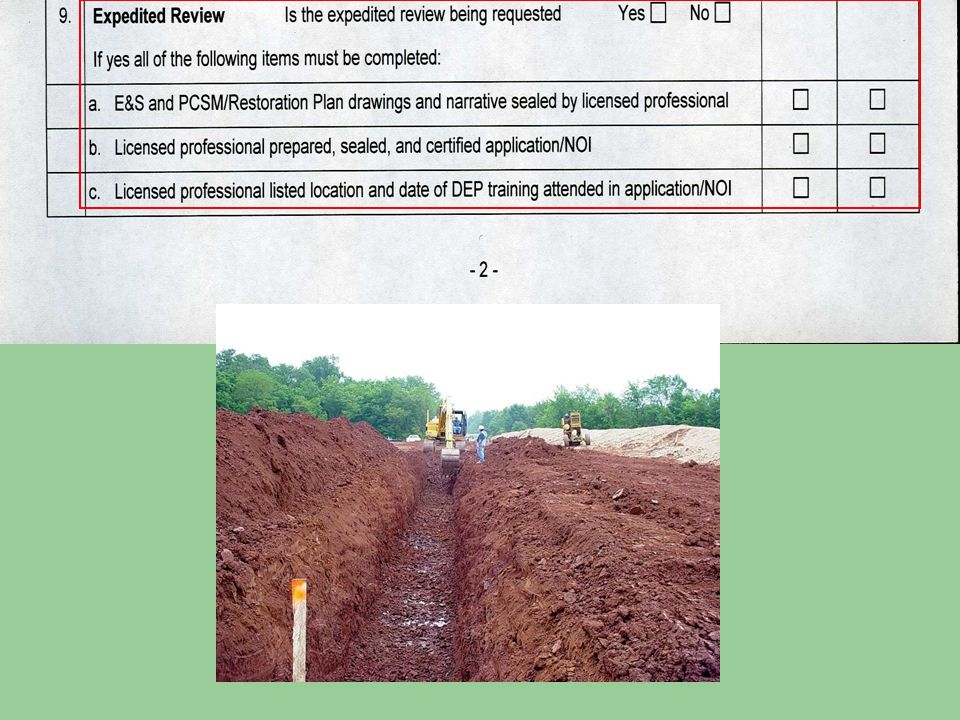
Expedited ESCGP-1 Administrative Review (Checklist)
Submit an ESCGP -1 Notice of Intent (NOI) at least 14 business days prior to any earth disturbance A sealed by a Licensed Professional (Engineer, Geologist,, Surveyor) Approval notice –written authorization within 14 business days (Fax, , followed up with hard copy. (Dept.) Expedited Approach is not mandatory Earth disturbance activities cannot begin until you receive the permit authorization PA Bulletin Final Action Notice (Dept.)
 at least 14 business days prior to any earth disturbance. A sealed by a Licensed Professional (Engineer, Geologist,, Surveyor) Approval notice –written authorization within 14 business days (Fax, , followed up with hard copy. (Dept.) Expedited Approach is not mandatory. Earth disturbance activities cannot begin until you receive the permit authorization. PA Bulletin Final Action Notice (Dept.)")
11
Standard ESCGP-1 NOI Application
-Submit a standard ESCGP-1 NOI application at least 60 days prior to earth disturbance - NOI Review & Approval issued - PA Bulletin Final Action Notice

12
Where do you apply for an ESCGP-1?
Applications: Requests for coverage should be submitted to the regional DEP Oil and Gas Program Office. DEP regional O&G program offices will process all Oil & Gas related erosion, sediment and stormwater permit applications except those related to transmission lines and facilities (inter and intra state pipelines).
.")
13
ESCGP-1’s for Transmission Lines and Associated Facilities
Delegated Conservation Districts will process these permits (Chapter 102 permit review responsibilities) Non- Delegated Counties – DEP Regional Office Watershed Management Program There is no Expedited process for these permits Definition of Transmission Line:
 Non- Delegated Counties – DEP Regional Office. Watershed Management Program. There is no Expedited process for these permits. Definition of Transmission Line:")
14
Transmission Line Definition:
Transmission lines (inter and intra state) include compressor stations, gas processing facilities and all other pipelines and facilities downstream of the production and gathering line system
 include. compressor stations, gas processing facilities and all other pipelines and. facilities downstream of the production and gathering line system.")
15
Delegated Responsibilities
Delegated conservation districts will be responsible for inspection and complaint response for all transmission facility earth disturbances. For non-delegated counties the appropriate regional DEP Watershed Management program shall have program responsibility

16
Non-Delegated Counties
Oil and Gas Exploration, Production, Processing and Treatment Projects Bureau of Oil & Gas Management Regional Office (SWRO, NWRO or NCRO) Transmission Line Projects Appropriate Bureau of Watershed Management DEP Regional Office
 Transmission Line Projects. Appropriate Bureau of Watershed. Management DEP Regional Office.")
17
The ESCGP-1 Notice of Intent (NOI)
Application Get it right the first time if you don’t waste time and risk the chance of have in it returned and lose your $$$$$!

19
The Total Project Area Entire area of activity, development or sale including, the area of an earth disturbance activity, the area planned for an earth disturbance activity and other areas which are not subject to an earth disturbance activity. Enter the size of the area in acres to the nearest tenth of an acre. (this could be the leased area)
")
20
Disturbed Area - Total Disturbed Area is that portion of the total project area where earth disturbance activities are planned to occur over the life of the project. - For phased projects, this refers to the disturbed area of the initial project phase plus the planned disturbed areas of subsequent project phases. - Enter the size of the area in acres to the nearest tenth of an acre.

21
Provide the name by which this proposed earth disturbance activity or project is, or will be, known.
Check all boxes that best describe the general type of activity. In the description, provide details such as number of wells to be drilled. Does the include everything? How about compressor stations, pipelines, borrow pits etc.?

22
Provide the latitude and longitude coordinates for the approximate center of the project area or facility Locate the project area on an 8 ½" x 11" photocopy of the U.S.G.S. topo map area. If the project is to be phased, provide an estimate of the timetable for the major phases. For each major phase, provide a description of the activity undertaken during the phase, total area of the phase, the disturbed area of the phase and the start and end dates for each phase of the activity. 7. List the existing and previous land use. If the stormwater discharge contains a pollutant other than sediment, list the pollutant, the source of the pollutant and concentration. Provide a plan for removal of the pollutant.

24
Phased ESCGP-1 Permits Applicants continue to have the option to utilize a “phased permit” approach. Use the DEP Policy on Phased NPDES Stormwater Discharges Associated with Construction Activity Permits, Chapter 102 Erosion and Sediment Control Permits and Chapter 105 Waterway Restoration Permits, DEP No. 363‑ This policy is available on e-Library.

25
Phased Projects Operator may wish to develop the project over time or in phases. If an operator plans to develop the entire or part of the lease or mineral estate over time, but the well spacing or location cannot be determined until some wells are drilled, an ESCGP-1 may be obtained for the entire area with approval of the first increment or phase. Part of policy of the Department to ensure projects requiring DEP permits are reviewed as complete projects and meet all public health, safety and environmental requirements. Including any part or a phased project.

26
Phased Projects For coverage by ESCGP-1 for phased projects an applicant must submit the following: For the entire project area A completed notice of intent (NOI) for ESCGP-1 An application must be accompanies by a check with the appropriate permit application fee. The application should be calculated based on the total disturbed acreage of the entire project. Municipal notifications to all county(ies) and municipality(ies) and proof of receipt. Complete PNDI form and search receipt(s) for all phases of the project site. An erosion and sediment control plan (E & S Plan) and Site Restoration Plan containing the following information: The existing topographic features for the project site and immediate surrounding area. The types, depth, slope, locations and limitations of the soils. A narrative description and plan drawings showing the locations and the characteristics of the earth disturbance activity including past, present and proposed land uses and a description of the planned physical alterations, earth disturbances and other construction activities, as well as a general description and location of anticipated BMPs, including BMPs for special protection waters.
 for ESCGP-1. An application must be accompanies by a check with the appropriate permit application fee. The application should be calculated based on the total disturbed acreage of the entire project. Municipal notifications to all county(ies) and municipality(ies) and proof of receipt. Complete PNDI form and search receipt(s) for all phases of the project site. An erosion and sediment control plan (E & S Plan) and Site Restoration Plan containing the following information: The existing topographic features for the project site and immediate surrounding area. The types, depth, slope, locations and limitations of the soils. A narrative description and plan drawings showing the locations and the characteristics of the earth disturbance activity including past, present and proposed land uses and a description of the planned physical alterations, earth disturbances and other construction activities, as well as a general description and location of anticipated BMPs, including BMPs for special protection waters.")
27
Phased Projects For coverage by ESCGP-1 for phased projects an applicant must submit the following: The location of all surface waters, which may receive runoff within or from the project site and their classification pursuant to Chapter 93. Procedures to ensure the proper handling, storage, control, disposal and recycling of wastes or other materials that have potential to cause pollution. A narrative description and a map (USGS topographic quadrangle or equivalent) of the project area that identifies the location and characteristics of sensitive areas or areas of environmental concern for the project site. Sensitive areas or areas of environmental concern include but are not limited to: wetlands, special protection waters, historic or cultural resource areas and areas where threatened endangered special or critical habitat may be present
 of the project area that identifies the location and characteristics of sensitive areas or areas of environmental concern for the project site. Sensitive areas or areas of environmental concern include but are not limited to: wetlands, special protection waters, historic or cultural resource areas and areas where threatened. endangered special or critical habitat may be present.")
28
Phased Projects For the initial phase (and each subsequent phase) of the project: A detailed description identifying the specific BMPs that will be used, plan details, drawings, specifications and a sequence of BMP installation The amount of projected runoff and supporting calculations for each BMP. E&S plan drawings identifying the location and boundaries of the phase, the locations of BMPs that will be used, construction details, specifications and a legend. Typical sketches may be used but must provide sufficient detail to illustrate critical dimensions and construction requirements. Maintenance program including the inspection of BMPs on a weekly basis and after each measurable rainfall event and the type of maintenance required for each BMP to ensure effectiveness. A site restoration plan that meets the following requirements of 25 Pa Code §102.8, subsections (b), (c), (e), (f), (h), (i), (l) and when applicable (m) Phased Projects and Conceptual Future Activities can not be used to circumvent the five acre threshold of earth disturbance.
, (c), (e), (f), (h), (i), (l) and when applicable (m) Phased Projects and Conceptual Future Activities can not be used to circumvent the five acre threshold of earth disturbance.")
29
Next named stream downstream
There may be more than one Enter the Name of the Corporation, Partnership, Agency or Individual and all other required information.

30
Permittees and Co-permittees
All operators that are not permittees must be included as co-permittees on the ESCGP-1 authorization. Operators include: Any entity that has oversight responsibility of earth disturbance activity on a project site or a portion of the project site that has the ability to make modifications to the E&S plan restoration plan or site specifications Or day-to-day operational control over earth disturbance activity on a project site or a portion of the project site to ensure compliance with the E&S plan or restoration plan

31
Required for additional individuals, partners or operators to be co-permittee. Enter the Name of the Corporation, Partnership, Agency or Individual. Provide the name of the site at the specific physical location. Do not use abbreviations, acronyms, etc. Provide the physical address of the location where the permitted activities will occur. No PO Box Numbers will be accepted for site location information. Provide the city (or municipality), state, and the ZIP+4. When providing written directions, do not use PO Box address data. Include landmarks and approximate distances from the nearest highway. Indicate the county(ies) and municipality(ies) in which the site is located.
, state, and the ZIP+4. When providing written directions, do not use PO Box address data. Include landmarks and approximate distances from the nearest highway. Indicate the county(ies) and municipality(ies) in which the site is located.")
32
The attached PCSM Plan must be a separate, distinct and complete plan.
There could be cases where none of these are checked then E-3 must be filled out

33
Attach three (3) copies of the PCSM Plan that includes a written narrative, identification and location of BMPs, plan drawings of BMPs, operation and maintenance procedures and supporting calculations and measurements
 copies of the PCSM Plan that includes a written narrative, identification and location of BMPs, plan drawings of BMPs, operation and maintenance procedures and supporting calculations and measurements")
34
Supporting calculations and measurements are not required if ALL the earth disturbance area within the project boundary is permanently revegetated or otherwise stabilized with pervious materials, the approximate original contours are maintained Post Construction Stormwater BMPs are used that use natural measures to eliminate pollution, do not require extensive construction efforts, promote pollutant reduction, and are capable of controlling the net increase in the volume and rate of stormwater runoff from a 2‑year/24 hour storm event and infiltrates the net increase of the post construction runoff

35
If the proposed post construction stormwater BMPs will not infiltrate all the net increase in stormwater runoff volume, please explain how you plan to manage the increased stormwater runoff volume Please check the appropriate box and list the existing BMPs that will be used or expanded.

36
The amount of impervious area on the project site as determined by the dominant land condition or land use for the five (5) years preceding the planned project. The amount of impervious area on the project site after the completion of the project. Remember dirt and gravel roads can be impervious Subtract pre from post

37
The amount of stormwater that would runoff the project site during the design storm event as determined by the dominant land condition The amount of stormwater that would runoff from the project site after construction if the planned stormwater BMPs were not installed. Subtract pre from post

38
The amount of stormwater that will run off from the project site after the planned stormwater BMPs are installed. Subtract post-construction volume with BMPs from pre-construction volume

39
Show the stormwater runoff discharge rate for the design frequency storm event as determined by the dominant land condition Show the stormwater runoff discharge rate for the storm event after the planned stormwater BMPs are installed. Subtract pre from post

40
Please check all the boxes that apply to the plan
Please check all the boxes that apply to the plan. If there is no check box for a planned BMP, check the box for “other” and list the BMP.

41
Provide the information requested in accordance with 25 Pa Code Chapter 93.4(a), Chapter 102.4(b)(6), the Oil and Gas Operator’s Manual and the Oil and Gas Stormwater Policy if the earth disturbance activity is in a Special Protection Watershed.
, Chapter 102.4(b)(6), the Oil and Gas Operator’s Manual and the Oil and Gas Stormwater Policy if the earth disturbance activity is in a Special Protection Watershed.")
42
Provide the information requested. Use additional pages if necessary.
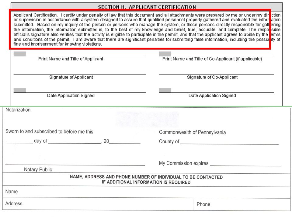
The person responsible for preparing the Erosion and Sediment Control Plan and Post Construction Stormwater Management Plan must complete this section.

45
Notice of Intent (NOI) ESCGP-1 Checklist
NOTICE OF INTENT (NOI) ADMINISTRATIVE COMPLETENESS CHECKLIST EROSION AND SEDIMENT CONTROL GENERAL PERMIT FOR EARTH DISTURBANCE ASSOCIATED (ESCGP-1) WITH OIL AND GAS EXPLORATION, PRODUCTION, PROCESSING, OR TREATMENT OPERATIONS OR TRANSMISSION FACILITIES
 ADMINISTRATIVE COMPLETENESS CHECKLIST EROSION AND SEDIMENT CONTROL GENERAL PERMIT FOR EARTH DISTURBANCE ASSOCIATED (ESCGP-1) WITH OIL AND GAS EXPLORATION, PRODUCTION, PROCESSING, OR TREATMENT OPERATIONS OR TRANSMISSION FACILITIES.")
46
ESCGP-1 Checklist

47
What specific page is the item located
Is it in the narrative or on the drawings a D or N should be used What specific page is the item located

53
Licensed professional seal goes on the plan

54
Notice of Termination-Completed Project
Must do all: When all stormwater discharges associated with the earth disturbance activity authorized by this permit are eliminated, The disturbed area has been permanently stabilized (70% or more) BMPs identified in the Site Restoration Plan have been installed.
 BMPs identified in the Site Restoration Plan have been installed.")
55
Notice of Termination The facility name, address and location
The operator name and address The permit number The reason for permit termination Identification of the person who have agreed to and will be responsible for long-term operations and maintenance of the post construction stormwater management Until the permittee has received written approval of a notice of termination, the permittee remains responsible for compliance with the terms and conditions of the permit including post construction stormwater management requirements. A final inspection will be conducted and the notice of termination will be approved or denied within 30 days.

56
Applications for Coverage Summary
Requests for coverage under either Option are submitted to the regional DEP Oil and Gas Program Office. DEP regional O&G program offices will process all Oil & Gas related erosion, sediment and stormwater permit applications except those related to transmission lines and facilities (inter and intra state pipelines).
.")
57
DEP Permit Authorization Process Summary
After application for any option is submitted to the region, the follow process will apply: ESCGP-1 Standard review - reviewed for administrative and technical completeness. ESCGP-1 Expedited review – reviewed for administrative completeness. All ESCGP-1 may be transferred to new operator or authorized agent with completed form to appropriate DEP office. Upon authorization under any of these approaches, DEP will provide a public notice in the Pennsylvania Bulletin confirming the applicant’s authorization of coverage.

58
A plan is only as good as those who see it through
Final Thought A plan is only as good as those who see it through Preventing an environmental problem is easier and less expensive than correcting an environmental problem after it has occurred

59
Thank you! Christopher Tersine, Environmental Engineer
Division of Resource Management & Well Development Department of Environmental Protection Rachel Carson State Office Building 400 Market Street | Harrisburg, PA 17101 Phone: | Fax:

Similar presentations


 471-4220 Michael Crisco Program Specialist – Storm.>")


 Regulations Fulton County Conservation District 216 N. Second Street, Suite 15.>")


