Download presentation
Presentation is loading. Please wait.

1
Dallas/Fort Worth CASA RADAR TEST BED

2
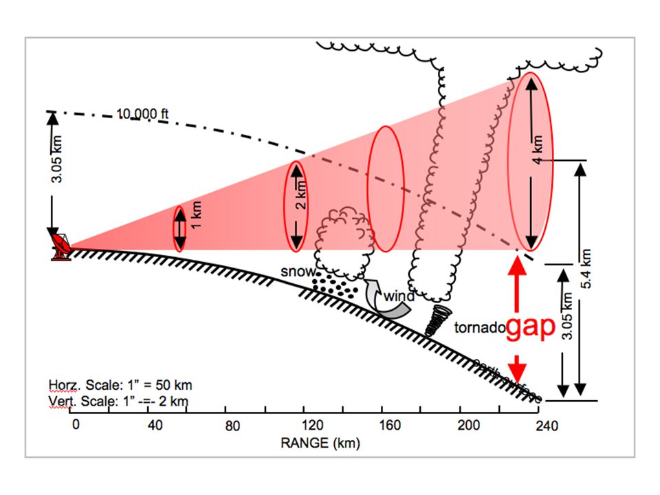
CASA Motivation NEXRAD coverage at 3 km (10,000 ft) AGL.
While radar beam travels essentially straight lines, the earth is curving down and away, leaving a low-altitude coverage gap. NEXRAD coverage at 1 km (~3200 ft) AGL.
 AGL.")
4
CASA’s Solution snow wind tornado earth surface 40 80 120 160 200 240 RANGE (km) Dense networks of low power, dual pol, multi-Doppler, X-band radars High spatial and temporal resolution Adaptive scans based on weather, user needs and radar capabilities

5
What is CASA? National Science Foundation Engineering Research Center
Academic, Government and Private Sector Partners NOAA is a CASA partner Developing new weather observation systems based on low-power, low-cost networks of radars. Transition research to operations. Year 8 of a 10-year research project

6
Comprehensive radar data in the lower atmosphere
Purpose: Establish a radar network in the Dallas-Fort Worth area using CASA technology. Comprehensive radar data in the lower atmosphere Faster radar return rate Higher resolution Flood and Wind (thunderstorm, tornado) forecasts Flood and Wind decision support tools Base level radar data Public/Private Partnership
 forecasts. Flood and Wind decision support tools. Base level radar data. Public/Private Partnership.")
7
NEXRAD = 5 min between updates
CASA = 1 min between updates Rapid, High Res. “smart” scans balance competing user needs for data adapt to changing weather RHIs, PPIs, dual Doppler, sector scans, within a volume scan Improved resolution, sensitivity, accuracy, and ability to support multiple users and multiple applications.

8
Collaborative Adaptive Scanning Meteorological Command and Control
Full explanation May 14, 2009 Anadarko Tornado

9
Improve Forecaster/EM/Spotter Decisions
EM Communicator CASA on AWIPS CASA on WDSS-ii NWS Forecaster NWS Chat Twitter EMs in Mobile EOC CASA/WXscope Spotters EM in EOC

10
Steering Committee City of Dallas City of DeSoto City of Fort Worth
City of Grapevine City of McKinney City of Midlothian City of North Richland Hills City of Seagoville Collin County Denton County DFW Airport Johnson County Tarrant County National Weather Service North Central Texas Trauma Regional Advisory Council North Central Texas Council of Governments

11
Timeline May 2011 NCTCOG Approves Feasibility MOU with CASA
June 2011 CASA WX Steering Committee August 2011 CASA WX Funding Subcommittee September 2011 NWS Funds $500K toward DFW Testbed Demonstration Projects

12
Timeline Continues October 2011 Commence relocation of Oklahoma test bed to DFW area November 2011 Finalize initial sites February 2012 Complete installation of initial four radar network March 2012 Demonstration network operational June 2012 Finalize second round of radar sites October 2012 Complete installation of second round of radars

13
PROPOSED RADAR LAYOUT

14
Metro Area - This is the recommend placement of the first four sites.
Late winter 2012 – First 4 radars Summer 2012 – next 2 radars Fall 2012 – Next radar Winter – 2013 CSU The sites include UNT and UTA buildings, which have the best connectivity so far from all proposed sites and the FAA building, which is presumed to have good network access too. Covers the metroplex with very high resolution data, Covers the gap above the NEXRAD radar in Fort Worth. The north south orientation will capture storms coming from the northwest and into the metroplex, while the existing NEXRAD can give warning for storms coming from the southwest. Provides unprecdented low level coverage of the trinity river for flooding, and accurate precipitation estimates. Also provide coverage of rivers, lakes to the north which impacts precipitation estimates. Very fast updates (1 Min) for rapidly evolving severe weather in the Metroplex. Disadvantages: CASA will provide very low coverage, but some coverage provided by NEXRAD. This system will focus more on real time data vs. forecasts. Which airports are we covering in addition to DFW and Love Field. FIRST FOUR SITES: Site 7: UNT Discovery Park, Denton Site 3: Alliance Airport, FAA building Site 11: University of Texas, Arlington Site 2: TBD – Carrollton, near G. Bush Tpk. And Kelly Blvd Blue – submitted sites Green, Yellow : new sites 14
 for rapidly evolving severe weather in the Metroplex. Disadvantages: CASA will provide very low coverage, but some coverage provided by NEXRAD. This system will focus more on real time data vs. forecasts. Which airports are we covering in addition to DFW and Love Field. FIRST FOUR SITES: Site 7: UNT Discovery Park, Denton. Site 3: Alliance Airport, FAA building. Site 11: University of Texas, Arlington. Site 2: TBD – Carrollton, near G. Bush Tpk. And Kelly Blvd. Blue – submitted sites. Green, Yellow : new sites. 14.")
15
Site 5: Terrell Municipal Airport Site 9: Mesquite Metro Airport
Northeast Expansion - This configuration continues coverage over highly populated areas and gets into areas where there is more of a radar gap. NEXT FOUR SITES Site 5: Terrell Municipal Airport Site 9: Mesquite Metro Airport Site 13: McKinney Public Safety Building Site 3: TBD - Near Farm to Market Rd and County Rd. 536 15

16
Option #1: Expand to South West as one continuous network
Southwest Expansion. After the first eight radars, we could expand into the southwest which would provide more high resolution nowcasts and forecasts in the metroplex.. We could also consider going to the south west before going to the northeast. We do not have any site identified in this area. Option #1: Expand to South West as one continuous network TOTAL NETWORK SIZE = 12 RADARS 16

17
Option #2: Expand to SW as two disjoint networks
This is another possibility for southwest expansion that would incorporate the existing Nexrad radar, and also get us into more of a radar gap area and provide forecasts and nowcasts into the metroplex. Option #2: Expand to SW as two disjoint networks TOTAL NETWORK SIZE = 12 RADARS 17

18
Plan for Covering the Whole COG Area
Add 3 radars to connect the disjoint networks. Add 3 radars to expand in South East direction. Add 2 radars to expand in North East direction (including Commerce High School and one new site TBD at Merit, near Farm to Market Rd. 36 and County Rd. 1126) TOTAL NETWORK SIZE = 20 RADARS 18
 TOTAL NETWORK SIZE = 20 RADARS. 18.")
19
Proposed Demonstration Projects
Public Response to Severe Weather Warnings Neighborhood-based Flash Flood Warnings Development of Impacts-based Weather Information Emergency Management Training

20
Proposed CASAWx Budget
Phase/year Operations Costs Demonstration Costs Category NCT Region Sites* CASA Local, Federal and Private Partners Subtotal Ops Costs NCT RegionD CASA D Local, Federal and Private Partners D Subtotal Demo costs Total Project Phase Costs Relocation $ ,500 $ ,000 $ ,000 $ $ ,500 $ $ ,000 $ $ ,000 $ ,500 One $ ,000 $ ,000 $ ,000 $ ,100,000 $ ,000 $ 1,600,000 $ ,160,000 Two $ ,000 $ ,000 $ ,000 $ ,000 $ ,000 $ ,000 $ 1,650,000 $ ,205,000 Three $ ,000 $ ,650,000 Four Five Total $ ,652,500 $ ,000 $ ,000 $ ,000 $ ,357,500 $ ,200,000 $ ,400,000 $ 8,600,000 $ ,957,500 O&D cost share 49.2% 17.1% 21.7% 11.9% 100.0% 0.0% 25.6% 74.4% Total cost share 13.8% 4.8% 6.1% 3.3% 28.1% 18.4% 53.5% 71.9% *includes in-kind contributions from host jurisdictions

21
Total Project Cost Projections
Five year project timeline

22
CASA Wx Demonstration Cost Share
Five year project timeline

23
CASA Wx Operations Cost Share
*Includes in-kind costs, Five year project timeline

24
CASA Wx Total Project Cost Share
*includes in-kind costs fro host jurisdictions, Five year project timeline

Similar presentations


 Expected Result: 11 EFFECTIVE AND EFFICIENT MANAGEMENT PERFORMANCE AND OVERSIGHT OF THE ORGANIZATION Strategic Plan for the Enhancement.>")


 Alison Kitson, Programme Leader (CPD)>")


 January 31, 2011.>")
