Download presentation
Presentation is loading. Please wait.

1
Spatial Database Engine
Keith T. Weber, GISP GIS Director Idaho State University

2
Today’s Topics What is SDE? Why use SDE? SDE Data Structure
How is data stored within SDE? DEMO: Meet ArcSDE Professional GDB Enterprise workflow: Versioning and Replication

3
What is SDE? SDE A spatial database engine that works on an RDBMS.
Helps to serve geospatial data to clients via a network SDE Is SDE a database? Does SDE store data or just manage data that is stored elsewhere?

4
Why use SDE? = Advantages:
Data loss/integrity degradation through versioning Centralized data management Enterprise GIS Geo-spatial data is immediately usable = Define enterprise?

5
Why use SDE? (cont’d) Disadvantages Data management role
RDBMS administration Capital expenditure Cost: Return on Investment? Unknown now

6
To Use SDE…or Not To Use SDE…
What will help make this decision? ROI TCO Is this the correct technology for the problem? Let students brainstorm

7
ArcGIS Data Structures
GDB Vector Objects Shape files Coverages Raster Objects Grids Images

8
The GDB Can store tables (just information), vector feature classes, and raster layers
, vector feature classes, and raster layers")
9
Layers and Layer Files All GIS Datasets are considered LAYERs in ArcMap. A LAYER FILE is a file that you save in ArcMap to retain customized settings. This file refers to the LAYER (shape file, coverage, grid, or feature class) It displays the data with your saved visualization settings, textual annotation, etc.
 It displays the data with your saved visualization settings, textual annotation, etc.")
10
Workspaces Arc/Info Collection of ArcView shape files Geodatabases
Info folder Geodata sets (coverages, grids, TINs) Collection of ArcView shape files Geodatabases Hold on a minute…what in the world is a workspace? A workspace is a folder on your workstation where you store your GIS coverages and files. Each workspace needs an Info folder. You can instruct AI to create a workspace or AI will create a workspace for you when you set your workspace to an existing folder. How do you do this…simple type &workspace c:\winnt\profiles\…etc [NOTE THE &] If you are going to do all this typing it certainly makes sense to use AML’s. It will also be helpful to use AML’s to set up some routine configurations each time you run AI. To help you out and get you going I have created two simple AML’s that you should download from the Server and copy to your Personal profile folder. The personal folder will be your ROOT or HOME WORKSPACE. Your workspace will contain coverages. Coverages differ from themes in that they are a set of files stored in a coverage folder --the name of the coverage-- and the workspace’s info folder.
 Collection of ArcView shape files. Geodatabases. Hold on a minute…what in the world is a workspace A workspace is a folder on your workstation where you store your GIS coverages and files. Each workspace needs an Info folder. You can instruct AI to create a workspace or AI will create a workspace for you when you set your workspace to an existing folder. How do you do this…simple. type &workspace c:\winnt\profiles\…etc [NOTE THE &] If you are going to do all this typing it certainly makes sense to use AML’s. It will also be helpful to use AML’s to set up some routine configurations each time you run AI. To help you out and get you going I have created two simple AML’s that you should download from the Server and copy to your Personal profile folder. The personal folder will be your ROOT or HOME WORKSPACE. Your workspace will contain coverages. Coverages differ from themes in that they are a set of files stored in a coverage folder --the name of the coverage-- and the workspace’s info folder.")
11
Coverages Tic Bnd Arc AAT, PAT Lets explore a coverage.
Each coverage will contain a number of files. These are: Tic: The location of registration tics Bnd: The map extent of the coverage…boundary information Arc: Arc, Line work Arx: ArcIndex file, topological data Lab: Labels and label points AAT: Arc Attribute Table PAT: Point or Polygon Attribute Table LOG: Log file, a record of the coverage’s history Other topological database files exist as well. In this class and actually, whenever you work with AI, you will directly contact the TIC and BND files somewhat, but will use the AAT and PAT files most. The LOG file is also important but also as a reference. These files are stored in Info format. To access these you can use the Info module of AI and we will learn how to use it. You can also convert the files to Dbase files to viewing and editing.

12
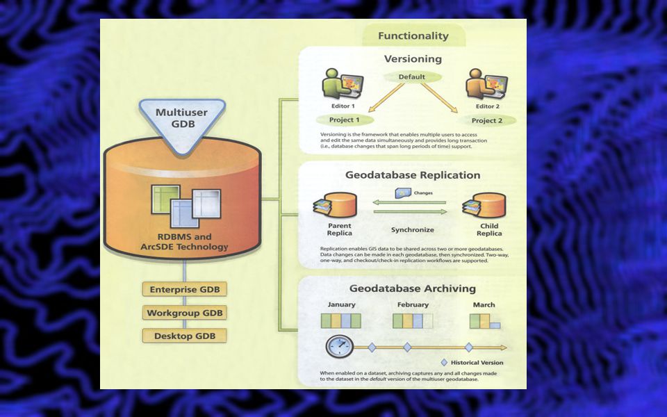
GeoDatabases Personal File-based ArcSDE Personal
ArcSDE Professional (or Enterprise)
")
13
Personal Geodatabases
Uses the MS Access Jet Database engine Note: Do not open/edit these with MS Access Limitations 2GB (Access) Only vector feature classes are actually stored inside the Access database 4 users but only one editor Does not support versioning
 Only vector feature classes are actually stored inside the Access database. 4 users but only one editor. Does not support versioning.")
14
File-based Geodatabase
fGDB Stores vector and raster layers in the file/folder structure. Limitations Multi-user (max = 10) 1 Editor (no versioning) Max size is 1 TB RDBMS
 1 Editor (no versioning) Max size is 1 TB. RDBMS.")
15
ArcSDE Personal Uses MS SQL Server Express Limitations 4 GB
Supports versioning/replication but only one editor

16
ArcSDE Professional Geodatabases
Uses DB2, Oracle, Informix, SQL Server, etc. No software size limits and unlimited number of users Can accommodate vector and raster data

17
Given all these differences, there are really many similarities

18
Geospatial Data Storage (Vector)
Geo-spatial data are stored as Feature classes Non-spatial data are stored as stand-alone tables Vector data is handled by DB2’s Spatial Extender. SDE is a broker. This schema shows paths for vector data storage as an example. Effectively, you must know and understand the data is stored as a feature class. It is no longer a coverage or a shape file. Raster data is also accommodated in SDE.

19
Geo-spatial Data Storage (Raster)
Two methods Stand-alone raster data set Mosaic ArcSDE is not the best solution to store raster GIS data for the Enterprise Size considerations Performance issues Raster data is handled by SDE Stand-alone: Each raster grid/image imported becomes its own raster layer in SDE. Embedded: Each raster grid/image imported has most of its data stored separately within the RDBMS tables, some parts are stored collectively sort of like a grouping in ArcMap. The data is displayed in one piece. Data returned to the user is the index value for the raster layer (1 (the first one added to the catalog) through n). Mosaic: All raster grids/images imported are mosaiced together into one piece. The data is stored as one unit and displayed as one unit. Building pyramids and calculating statistics is very important. The number of “stats” records and pyramids records changes too. BRAINSTORM BENEFITS AND ADVANTAGES…METHODS VARY FOR DIFFERENT DATA SETS…
 through n). Mosaic: All raster grids/images imported are mosaiced together into one piece. The data is stored as one unit and displayed as one unit. Building pyramids and calculating statistics is very important. The number of stats records and pyramids records changes too. BRAINSTORM BENEFITS AND ADVANTAGES…METHODS VARY FOR DIFFERENT DATA SETS…")
20
Internal Data Storage Within the DB2 RDBMS
All data is stored within table spaces –referred to by Configuration Keyword. A Configuration Keyword points to a set of two table spaces: Attribute table space Coords table space Table spaces are invisible to the user or client.

21
Loading Vector Data into a GDB
PART 1: Stand-alone feature classes Log into SDE as a manager level. In catalog Goto SDE, choose import Do singles…you will see why (field names)
")
22
The Spatial Index Grid Uniform grid of square tiles
Like grid reference on a street map Each feature (lakes) referenced by one or more tiles Envelope of feature determines tiles occupied Spatial Index Key records occurrences of features in tiles Empty tiles not stored Reference ID Grid X, Grid Y
 referenced by one or more tiles. Envelope of feature determines tiles occupied. Spatial Index Key records occurrences of features in tiles. Empty tiles not stored. Reference ID. Grid X, Grid Y.")
23
Loading Vector Data into ArcSDE
PART 2: Feature classes within a Feature Data Set First, you need a Feature Data Set What is a Feature Data Set? What is the precision of the source data What will the future data be like for this feature class The data storage precision value is determined during import. Rule of thumb: Doubling precision results in 10% more table space usage (HD usage). To change the precision of the data storage, click change settings Spatial reference tab XY Domain Lower the domain (by default ArcGIS will set the precision at its highest value. This is determined by the full spatial extent of the data set to be imported. (min, max X,Y). Also mention the item names import…query import….and keywords
. To change the precision of the data storage, click. change settings. Spatial reference tab. XY Domain. Lower the domain (by default ArcGIS will set the precision at its highest value. This is determined by the full spatial extent of the data set to be imported. (min, max X,Y). Also mention the item names import…query import….and keywords.")
24
A Feature Data Set is: Required to implement Full Topology! What?!

25
Full Topology “The spatial relationship among feature classes participating in a topology layer” Must belong to a feature dataset Feature classes share geographic reference system, and spatial domain. More realistic representation of data AKA Shared topology or Advanced Topology.

26
A Feature Data Set then…
Is an organizational tool used to ensure that all feature classes within it use a common: Geospatial reference system Spatial domain

27
Understanding the Spatial Domain
Low-precision GDB Based upon LONG INTEGER (32-bit) What is the domain range of a LONG? High-precision GDB Based upon 64-bit Integer Covers a geographic reference systems “Horizon” Both X and Y coords can be stored in 4B space
 What is the domain range of a LONG High-precision GDB Based upon 64-bit Integer. Covers a geographic reference systems Horizon Both X and Y coords can be stored in 4B space.")
28
Fitting the World into a LONG
If we express the X,Y coordinates in the familiar Latitude/Longitude system… By whole degrees, we would use: Latitude (180 units) Longitude (360 units) This is only % of the 4B space Calc shown is for Longitude
 Longitude (360 units) This is only % of the 4B space. Calc shown is for Longitude.")
29
Problems with this approach
Resolution to 1 degree is terrible Wastes the capacity of LONG INTEGER

30
What if we use Decimal Degrees?
Hold on! Decimals cannot be stored in an INTEGER data type Let’s just shift the decimal place to the right by multiplying the coordinate by a scaling factor e.g., 10 preserves one decimal place, 100 preserves decimal places etc.

31
Fitting the World into a LONG (revisited)
By using a scaling factor of 1M, the world would fit nicely into a 3.6B space (there’s even a bit left over!) What is the spatial resolution of 1/1Mth of a degree? Approximately 1/10th of a millimeter! In Idaho, there is approximately 10,000m per 7.5’ quad (along the X) That is 1,333 meters per degree That is /1millionth of a degree That then is 1/10th of millimeter!
 What is the spatial resolution of 1/1Mth of a degree Approximately 1/10th of a millimeter! In Idaho, there is approximately 10,000m per 7.5’ quad (along the X) That is 1,333 meters per degree. That is /1millionth of a degree. That then is 1/10th of millimeter!")
32
More about the High-Precision GDB
Can be pGDB, fGDB, or SDE GDB Uses 64-bit integer to encapsulate the spatial horizon What? 64-bit numbers have a range of 18,446,744,073,709,551,616 That‘s 18 quintillion!

33
The Spatial Horizon? Essentially, it’s a spatial domain large enough the contain the entire earth at high-precision

34
Applying this to ArcGIS
Rule #1, use the high-precision GDB model whenever possible. Why not always? Long is long paper. Precision may not be the best word…in actuality resolution would have been better.

35
Hints and Tips Optimize the spatial domain by using high-precision GDB Feature dataset If not, set up your low-precision Feature dataset to Allow for spatial growth Allow for improved instrumentation I would choose a precision of 1000 Make the min/max X,Y’s fit EVENLY around the study area or AOC

36
ArcSDE Professional Demo Import a vector data set into ArcSDE

37
The Future… SDE going away?

38
Think about it… Object-relational databases have native geospatial support ArcGIS for Server can make geospatial data available to the Enterprise Do we need an ArcSDE middle-ware? ArcGIS Spatial Data Server Spend some time discussing…

39
Questions…

40
Geodatabases in an Enterprise Workflow
Keith T. Weber, GISP GIS Director, ISU GIS Training and Research Center

41
Understanding and managing workflow
Presentation and Discussion Understanding and managing workflow

42
Let’s Get Started Adjectives GIS is… Data-driven Powerful Dynamic
GIS is many things…many adjectives can be used to describe it. For our workshop today however, there is one property of GIS that we will concentrate on and that is “GIS is Dynamic”

43
GIS Data Life Cycle Create Data Change Happens! Edition Backup Edit
Validate Update Metadata Change Happens! This cycle is not new… it is in fact, old…since the beginning of GIS this is how things were done. Let’s think about a roads layers. Create by digitizing…that is edition number one when it is done (fix the overshoots and dangles, and populate the database). Once we recognized that things have changed and our layer is outdated, we plan for how we will fix this. This is very task oriented… so we backup our data (copy it) and then proceed with editing it. Hopefully we validate our edits and update our metadata as well. Now we have a new edition of the roads layer and all is right with the world. There is nothing wrong with this cycle. IF the rate at which “change happens” and the demand/expectation for a new edition is not too frequent. For instance… 1 revolution per year or per quarter is not too bad. But what if the demand and expectation for a new edition…and the need for a need edition requires 1 revolution per week or per day?
. Once we recognized that things have changed and our layer is outdated, we plan for how we will fix this. This is very task oriented… so we backup our data (copy it) and then proceed with editing it. Hopefully we validate our edits and update our metadata as well. Now we have a new edition of the roads layer and all is right with the world. There is nothing wrong with this cycle. IF the rate at which change happens and the demand/expectation for a new edition is not too frequent. For instance… 1 revolution per year or per quarter is not too bad. But what if the demand and expectation for a new edition…and the need for a need edition requires 1 revolution per week or per day")
44
The Bottleneck Distributing the new edition

45
The Solution Networks and the Internet

46
A New Problem is Born “MY” version

47
GIS Grows Up! RDBMS Keep the benefit of network connectivity
Eliminate the problem of “MY” version Eliminate the bottleneck And, change the cycle of events

48
GIS Data Life Cycle Create Data Change Happens! Edition
Version and/or Replicate Edit Validate: Synchronize or reconcile and post Update Metadata Change Happens! Two things have changed: Wording/terminology: We don’t backup today, instead we version and replicate. We don’t just check things over as our validation, today we also need to synchronize or reconcile and post. Colors: this is important as it symbolizes a distributed workflow within a team environment… a team that is part of the enterprise. Blue = manager, orange = technician/specialist, and green = metadata librarian.

49
Backup vs. Versioning Backups and archiving are still critical steps for the enterprise. BUT, not part of the GIS Life Cycle any longer

50
In the Beginning… Backups were made in case we really messed up
Edits were made to the original Copies of the “clean” new edition were distributed

51
Today… The original [parent] is versioned [a child is born]
Edits are made to the child, not the parent “Clean” edits are copied [synchronized or posted] to the parent.
![Today… The original [parent] is versioned [a child is born]](http://slideplayer.com/slide/1512976/5/images/51/Today%E2%80%A6+The+original+%5Bparent%5D+is+versioned+%5Ba+child+is+born%5D.jpg "Edits are made to the child, not the parent. Clean edits are copied [synchronized or posted] to the parent.")
52
Benefits Of This Approach
Brainstorm!!! Minimize downtime Processes completed within the RDBMS

53
The Role of Backups Data retention and deletion Legal requirements

54
GIS Data Life Cycle…Today
Create Data Change Happens! Edition Version and/or Replicate Edit Validate: Synchronize or reconcile and post Update Metadata This process is enterprise enabled. The manager, technician, and librarian do not have to be in the same office. Indeed, this cycle is “outsourcing-ready”…

55
Questions/Discussion?

56
Replication and versioning
Presentation and Discussion Replication and versioning

58
What is Replication? Duplication Copying Mirroring Synonyms

59
True Replication… Does not need ArcGIS
Every RDBMS can be replicated natively However, using ArcGIS to perform the replication Is easy Supports GIS workflows better

60
Why Replicate? Enable disconnected editing for:
Performance/load balancing Network load reduction Publishing data to subscribers

61
Network Load Reduction
The network is a primary bottleneck in a High-Capacity Enterprise Note: capacity refers to how many concurrent users a system can support without loss of performance

62
How Do I Replicate? We will cover this with the hands-on exercise
As an overview… Version the database Replicate the database Edit/update Synchronize changes with the parent

63
So Replication is Versioning
No… but replication uses a versioned database

64
What is Versioning? One database
Parent edition (tables) remains live/usable Child edition(s) simultaneously edited Roll-up is seamless
 remains live/usable. Child edition(s) simultaneously edited. Roll-up is seamless.")
65
Versioning: Principal Concepts
Edits are stored in “Supporting Tables” Geographic changes (linework) are stored in Supporting Vector Tables Attribute changes are stored in Supporting Delta Tables.
 are stored in Supporting Vector Tables. Attribute changes are stored in Supporting Delta Tables.")
66
Delta Tables A = Add (insert) D = Delete
U = Update (delete existing then add)
")
67
A Tree is Formed As versions are created and changes are made, a tree grows Q: What kind of tree? A: A State Tree

68
Sort of an Upside-down Tree

69
The State Tree Tree Trunk Branches Default: state 0
Arthur’s Court sub-division [Another] sub-division Branches

70
Multiple Versions Multiple versions are allowed
Versions can be based upon location (north edits, south edits), projects (sub-divisions), or other logic decided upon my the GIS Manager. Batch reconcile and post are supported
, projects (sub-divisions), or other logic decided upon my the GIS Manager. Batch reconcile and post are supported.")
71
The Day of Reconciliation
Arthur’s Court sub-division edits have been completed Time to reconcile This process looks for conflicts Once all conflicts have been resolved… Reconciliation is complete

72
Post To roll-up the edits back to the “trunk of the state tree” we Post

73
Considerations Performance can degrade with active databases
Workflow itself can generate unnecessary versions Delta tables will become large over time DBMS statistics may need to be refreshed or reviewed by the DB Admin

74
The Cure For many of these ArcGIS-centric performance issues is compressing the database Moves common rows from delta tables into base tables Reduces depth of the state tree by removing states no longer needed

75
Compression Example Active editing sessions are shown in yellow
Versions with no deltas since last reconcile/post are shown in hollow GIS Manager compresses, says, I do not need these versions any longer. They are eliminated.

76
Questions/Discussion?

77
Hands-On Exercise Practice both replication and versioning

78
Your Assignment Complete the exercise handouts
Connecting to and using SDE on DB2 Practice both replication and versioning Read the PDFs in the SDE exercise folder Visit the URL link for Spatial Data Server and explore this topic

79
Key Concepts SDE is an engine layer residing between a spatially-enabled RDBMS and the GIS desktop. SDE enables Enterprise GIS SDE reduces data management responsibilities. Understand Enterprise workflow

Similar presentations


 >")


