Download presentation
Presentation is loading. Please wait.

1
Introduction to Aerial Stereo Photographs
Scale Aerial photographs vary in scale according to the altitude of the plane above the ground and are the focal length of the lens of the camera. Scales are commonly expressed as fractions, as 1/20,000, which means that 1 inch on the photograph corresponds to 20,000 inches on the ground. (1 mile = 63,360 inches)
")
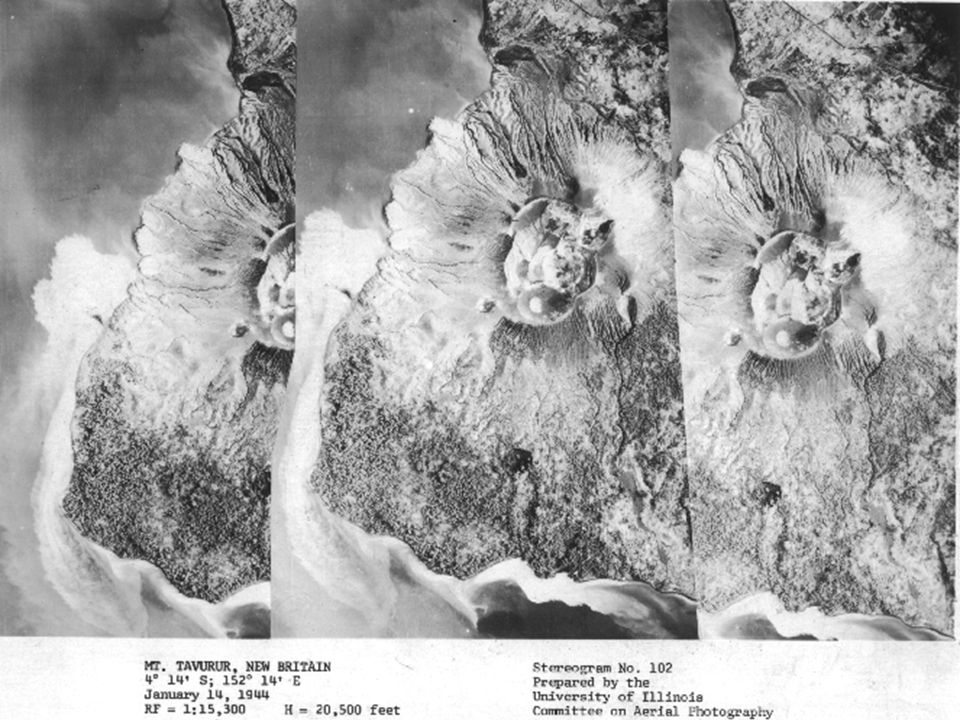
2
The Stereoscope Natural and man-made features can be seen in three dimensions with the aid of a stereoscope and two overlapping scenes. With the addition of depth, aerial photos can provide the interpreter with more information on geologic boundaries, terrain characteristics, relative heights, and regional topography. Adopted for application Back in the day…

4
To acquire aerial stereo photography a series of overlapping photos must be taken along a designated flight line. So that stereo coverage of an area will be complete, the amount of overlap for each adjacent pair of photos must be greater than 50%.

6
Introduction to Remote Sensing

8
Optical remote sensing makes use of visible, near infrared and short-wave infrared sensors to form images of the earth's surface by detecting the solar radiation reflected from targets on the ground. Different materials reflect and absorb differently at different wavelengths. Thus, the targets can be differentiated by their spectral reflectance signatures in the remotely sensed images

9
The LandSat Program – NASA & USGS
The Landsat Program is a series of Earth-observing satellite missions. Since 1972, Landsat satellites have collected information about Earth from space. This science, known as remote sensing, has matured with the Landsat Program. In its more than 25 year history, the Landsat Program has provided millions of images of the Earth, giving scientists a unique resource for global change research and applications in agriculture, geology, forestry, regional planning, education and national security.

10
The Atlantic current in infrared

11
Earth Observing System (EOS) - NASA
 - NASA")
16
Tsunami Strikes Sri Lanka: On December 26, 2004, tsunamis swept across the Indian ocean, spawned by a magnitude 9.0 earthquake off the coast of Sumatra. Aside from Indonesia, the island nation of Sri Lanka likely suffered the most casualties, with the death toll reported at 21,715 on December 29th. DigitalGlobe’s Quickbird satellite captured an image of the devastation around Kalutara, Sri Lanka (top), on December 26, 2004, at 10:20 a.m. local time—about an hour after the first in the series of waves hit. (A Quickbird image taken on January 1, 2004 (lower), shows the normal ocean conditions.) Water is flowing out of the inundated area and back into the sea, creating turbulence offshore. Some near-shore streets and yards are covered with muddy water. It is possible that the image was acquired in a “trough” between wave crests. Imagery of nearby beaches shows that the edge of the ocean had receded about 150 meters from the shoreline. Click on image to enlarge. Credit: Images Copyright DigitalGlobe
, on December 26, 2004, at 10:20 a.m. local time—about an hour after the first in the series of waves hit. (A Quickbird image taken on January 1, 2004 (lower), shows the normal ocean conditions.) Water is flowing out of the inundated area and back into the sea, creating turbulence offshore. Some near-shore streets and yards are covered with muddy water. It is possible that the image was acquired in a trough between wave crests. Imagery of nearby beaches shows that the edge of the ocean had receded about 150 meters from the shoreline. Click on image to enlarge. Credit: Images Copyright DigitalGlobe.")
17
These high-resolution satellite images, acquired by Space Imaging’s Ikonos satellite, show Lhoknga before (lower) and after (top) the earthquake and Tsunami. Almost all the trees, vegetation, and buildings in the area were washed away. Behind the town, low-lying agricultural areas remained covered with water four days after the disaster, and sand on the nearby beaches was completely removed. The wave height might have exceeded 15 meters (50 feet) when it struck the shore.
 when it struck the shore..")
Similar presentations


 means hello and (Nami) means wave. A brief series of long, high waves on the surface.>")