Download presentation
Presentation is loading. Please wait.

1
10. The Glaciation of Canada
Quaternary periods – time scales The older glacial period Pre-Sangamon Sangamon interglacial Early and middle Wisconsin events The late Wisconsin Glacial lakes Depositional and erosional zones

2
(a) Quaternary periods (geological time scales)
Quaternary period: last 1.65 million years Quaternary: Holocene (last 10,000 years) Pleistocene . Wisconsin glacial (from 75 ka) . Sangamon (interglacial); from 130 ka . Early Pleistocene (ka: thousands of years)
 Pleistocene. . Wisconsin glacial (from 75 ka) . Sangamon (interglacial); from 130 ka. . Early Pleistocene. (ka: thousands of years)")
3
(b) The older glacial period
Pre-Sangamon: Some evidence of glacial and nonglacial stages dating back to early Pleistocene Evidence of pre-Wisconsin glaciations in several areas (sometimes as many as three) e.g. presence of till beneath deposits considered to be of Sangamon age
 e.g. presence of till beneath deposits considered to be of Sangamon age.")
4
Sangamon Interglacial and early Wisconsin events
Late Pleistocene stratigraphy of Toronto area (e.g. exposed along Scarborough Bluffs): Why lacustrine sediments: elevation above lake Ontario suggests that water level was as much as 20 m higher than today Early and middle Wisconsin events: from 75,000 to 23,000 years ago: no consensus on the extent of glacial ice in Middle Wisconsin (Non-glacial conditions in western Canada and major part of Ontario probably).
: Why lacustrine sediments: elevation above lake Ontario suggests that water level was as much as 20 m higher than today. Early and middle Wisconsin events: from 75,000 to 23,000 years ago: no consensus on the extent of glacial ice in Middle Wisconsin (Non-glacial conditions in western Canada and major part of Ontario probably).")
5
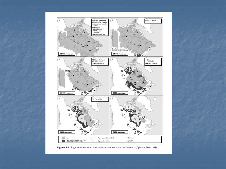
(c) The late Wisconsin Continental ice sheet in late Wisconsin (from 23,000 to about 10,000 years ago) General agreement on at least three ice centers (centers of ice accumulation and dispersal) These centers controlled independent flow patterns and ice “divides”
 These centers controlled independent flow patterns and ice divides")
6
Laurentide Ice sheet Three ice caps:
High arctic glacial complex Cordilleran glacial complex Ice flowing radially outwards from a central dome located over Hudson Bay Extent of Laurentide ice sheet and retreat:

7
Maximum dimensions approximately 18,000 years ago
Slight changes in position from 18,000 to 14,000 years ago Significant retreat after about 13,000 years About 11,000 years ago, formation of the Champlain sea in St-Lawrence valley

8
Extent – retreat of Laurentide ice sheet (cont.)
8000 years ago: Tyrell sea in Hudson Bay; regional ice masses predominant Final retreat only about 6000 years ago (Labrador – New Quebec ice)
")
10
(d) Glacial Lakes and seas
Isostasy (glacial isostasy): Involved the depression of the land owing to the weight of a large body of ice, and uplift or rebound as a result of disintegration or retreat of the ice Ice retreated, sea flooded depressed coastal regions
: Involved the depression of the land owing to the weight of a large body of ice, and uplift or rebound as a result of disintegration or retreat of the ice. Ice retreated, sea flooded depressed coastal regions.")
11
Proglacial lakes and seas
Champlain sea Goldthwait sea; Gulf of St-Lawrence, east of Quebec city Tyrell sea; around Hudson Bay Largest lakes formed around the margins of the Laurentide ice sheet.

12
Formation of glacial lakes
Glacial meltwater confined between ice margin (as glacier retreats) and higher land (deglaciated) Retreating ice prevents drainage towards Hudson bay Tow main reasons: Isostatic uplift Fluctuations in position of ice margins
 and higher land (deglaciated) Retreating ice prevents drainage towards Hudson bay. Tow main reasons: Isostatic uplift. Fluctuations in position of ice margins.")
13
Proglacial lakes More than 50% of the area occupied by Laurentide ice sheet was, following the deglaciation, covered by water Largest proglacial lakes: Agassiz and Barlow-Ojibway Agassiz: Biggest of all proglacial lakes. Disappeared about years ago.

14
Lake Aggassiz Covered, at it maximum extent, almost 106 km2 in Northern USA, as well as major parts of Ontario, Manitoba and Sask. Began its formation 11,700 years ago while Laurentide ice sheet was retreating

15
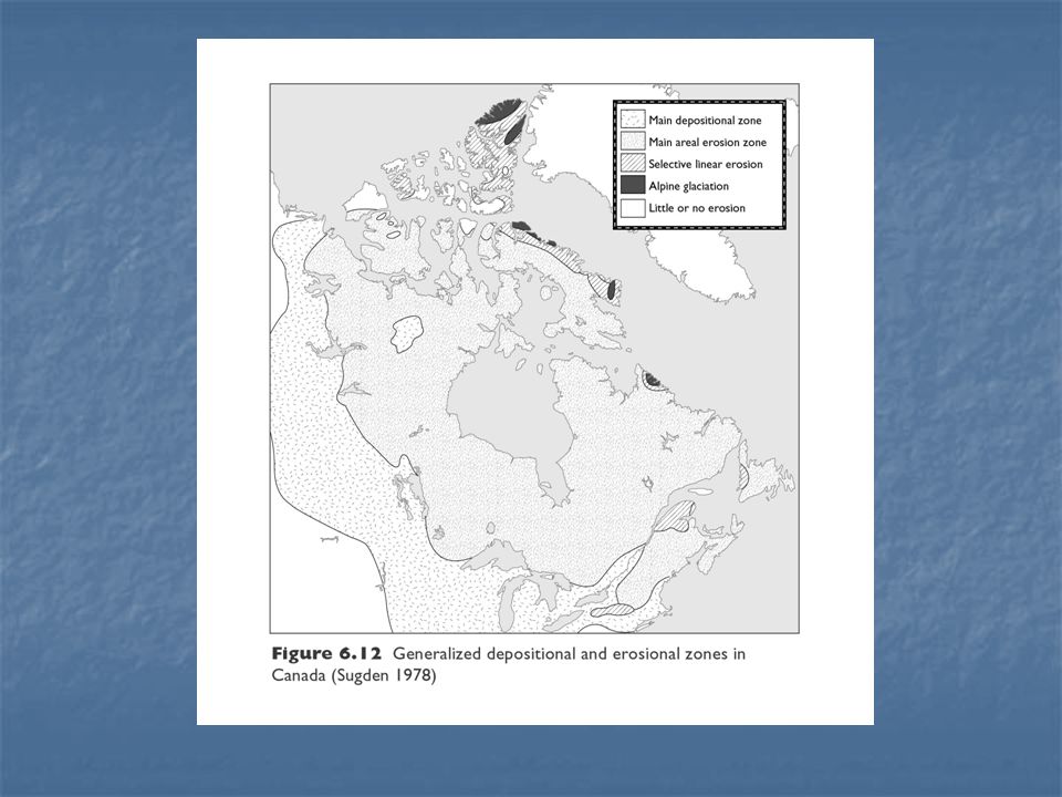
(e) Depositional and erosional zones in Canada
Conflicting opinions about amount of erosion associated with continental ice sheets of north America Unconfined glacial flow does not accomplish large amounts of erosion (as opposed to confined, valley glaciers, fro instance). e.g.: tills deposited near margins of continental ice sheets do not contain large amounts of shield material
. e.g.: tills deposited near margins of continental ice sheets do not contain large amounts of shield material.")
16
Last glaciation: average depth of erosion of the order of 1-2 m??
Most research workers believe that total amount of glacial erosion on the shield during the whole Pleistocene was less than 20 m.

17
Tills… Tills: poorly sorted (i.e. wide range of particle sizes), glacially deposited sediment. Characteristics of a till in a given area determined by: Type of bedrock Way debris are carried by ice Distance of travel Glacial erratics: rock fragments carried by the ice from their place of origin and left in an area where there is a different type of bedrock.

18
Tills and moraines Most tills in Canada formed in the Wisconsin glacial stage (23,000 to 10,000 years B.P.) Tend to have a rather coarse matrix; thickness often of the order of a few meters (although highly variable locally)
")
19
Glacial erratics… Current view of glacial flow patterns associated, in part, with presence of erratics and tills Erratics distributed in long, narrow dispersal trains, extending back to their source areas

22
Moraines Ridges or mounds of glacial material deposited at, or close to, the ice margins Terminal moraine: observed close to the former margin of the ice sheet; not common in central zones where ice retreated and melted When mapped, terminal moraines provide valuable indications of the position(s) of the ice margin.
 of the ice margin.")
23
Terminal moraines in Canada

24
Note on Oak Ridges Moraine
Formed about 13,000 years ago, at the margin of an advancing ice lobe. Part of the deposit was overridden and covered by the advancing ice.

25
Deglaciation – the “Ontario island”

26
Moraines of southern Ontario

27
Drumlins Drumlins: a mound of glacial debris with the longitudinal axis parallel to the direction of ice movement Origin still a matter of debate. Differential erosion of bedrock Hollows at the base of glaciers (due to subglacial meltwater), subsequently filled with sediment Length-to-width ratios: 1:3 Height: meters common.
, subsequently filled with sediment. Length-to-width ratios: 1:3. Height: meters common.")
28
Drumlin formation and morphology

29
Eskers Sinuous ridges of glaciofluvial material.
Long eskers constructed in stages as ice margins retreated Two major formation processes: Streams contained within tunnels running through the ice or along its floor In open, ice-walled trenches Stagnant ice provides sufficient meltwater for the formation of eskers.

30
Eskers (cont.) During final deglaciation stages, down-wasting and ice stagnation. Esker formation in tunnels at the ice base (more eskers on the shield than surrounding areas)
")
32
Orientation of streamlined features

33
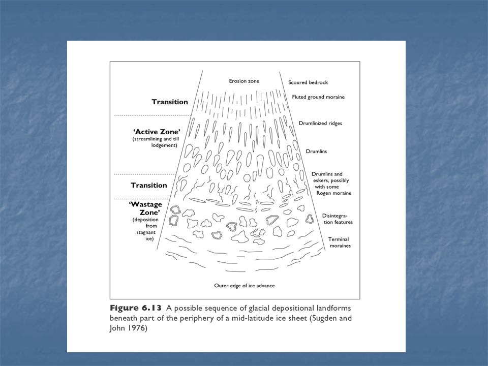
Sequence of depositional landforms
A simple model to account for the distribution of glacial depositional landforms from an ice dispersal centre Erosion dominates in the vicinity of the ice dispersal centre. Deposition becomes progressively more important as we move towards outer zone Basal debris “streamlined” Deposition and glaciofluvial deposits by meltwater dominates the outer area.

Similar presentations