Download presentation
Presentation is loading. Please wait.

1
GMS- EAST WEST CORRIDOR “CHALLENGE AND OBSTRACLE”
Arranged by Mrs. Tui Pakarat-Rutten Vice President of TBCC & Managing Director of Intra Co Ltd. On 08 Oct 2015 H/P: /

2
Contents GMS GMS Corridors 3. GMS CBTA 4. East West Corridor
5. Myanmar Profile 6. Myanmar SEZ 7. Cambodia Profile 8. Cambodia SEZ 9. Thailand SEZ Policies at the border 10. Economic Corridors and Thailand -Plus - One

3
1.GMS-GREATER MEKONG SUB-REGION

4
Overview of the Greater Mekong Sub-region
The Greater Mekong Sub-region (GMS) is a natural economic area bound together by the Mekong River, covering 2.6 million square kilometers and a combined population of around 326 million. In 1992, with assistance from ADB, the six countries entered into a program of sub-regional economic cooperation, designed to enhance economic relations among the countries. Ref : ADB
 is a natural economic area bound together by the Mekong River, covering 2.6 million square kilometers and a combined population of around 326 million. In 1992, with assistance from ADB, the six countries entered into a program of sub-regional economic cooperation, designed to enhance economic relations among the countries. Ref : ADB.")
5
2. GMS CORRIDORS

6
GMS Corridors Ref : ADB There are three main economic corridors that have so far been defined in the GMS Program, namely: the East-West Economic Corridor (EWEC) – running from the Da Nang Port in Viet Nam, through Lao PDR, Thailand, and to the Mawlamyine Port in Myanmar; the North-South Economic Corridor (NSEC) – which covers the major routes running from Kunming to Chiang Rai to Bangkok via Lao PDR and via Myanmar, and from Kunming to Hanoi to Haiphong (and most recently, from Nanning to Hanoi); and the Southern Economic Corridor (SEC) – which runs through southern Thailand, Cambodia, and southern Viet Nam.
 – running from the Da Nang Port in Viet Nam, through Lao PDR, Thailand, and to the Mawlamyine Port in Myanmar; the North-South Economic Corridor (NSEC) – which covers the major routes running from Kunming to Chiang Rai to Bangkok via Lao PDR and via Myanmar, and from Kunming to Hanoi to Haiphong (and most recently, from Nanning to Hanoi); and. the Southern Economic Corridor (SEC) – which runs through southern Thailand, Cambodia, and southern Viet Nam.")
7
All GMS Corridors Ref : ADB

8
3. GMS CBTA

9
GMS - CBTA What is GMS – CBTA History : Start from 26th November, 1999
Copy Right Somsak Wisetruangrot 2010 GMS - CBTA What is GMS – CBTA History : Start from 26th November, 1999 Thailand - Lao PDR - Vietnam (Tripatite Agreement) Under Grater Mekong Subregion Economic Cooperation (GMS-EC) to facilitate cross border of Goods transport and people What is GMS CBTA? GMS CBTA is Grater Mekong Sub-region Cross-Border Transport Agreement which is the important agreement and it boosts up the cooperation among the countries in the Mekong Sub-region. The GMS Cross-Border Transport Agreement (CBTA) is a compact and comprehensive multilateral instrument that covers all the relevant aspects of cross-border transport facilitation in one document. These include: - single-stop/single-window customs inspection - cross-border movement of persons, for example the visas for persons engaged in transport operations, - transit traffic regimes, including exemptions from physical customs inspection, bond deposit, escort, and agriculture and veterinary inspection , requirements that road vehicles will have to meet to be eligible for cross-border traffic - exchange of commercial traffic rights and infrastructure, including road and bridge design standards, road signs, and signals. It has been started from 26th November in year 1999 that Three Countries, namely Thailand, Lao PDR and Vietnam had reached to the agreement under GMS EC or Economic Cooperation to facilitate cross border of goods transport and passenger.
 Under Grater Mekong Subregion Economic Cooperation. (GMS-EC) to facilitate cross border of Goods transport. and people. What is GMS CBTA GMS CBTA is Grater Mekong Sub-region Cross-Border Transport Agreement which is the important agreement and it boosts up the cooperation among the countries in the Mekong Sub-region. The GMS Cross-Border Transport Agreement (CBTA) is a compact and comprehensive multilateral instrument that covers all the relevant aspects of cross-border transport facilitation in one document. These include: - single-stop/single-window customs inspection. - cross-border movement of persons, for example the visas for persons engaged in transport operations, - transit traffic regimes, including exemptions from physical customs inspection, bond deposit, escort, and agriculture and veterinary inspection , requirements that road vehicles will have to meet to be eligible for cross-border traffic. - exchange of commercial traffic rights and infrastructure, including road and bridge design standards, road signs, and signals. It has been started from 26th November in year 1999 that Three Countries, namely Thailand, Lao PDR and Vietnam had reached to the agreement under GMS EC or Economic Cooperation to facilitate cross border of goods transport and passenger.")
10
Copy Right Reserve @ Somsak Wisetruangrot 2010
GMS - CBTA 6th Transport Working Group Meeting of GMS Agreed to have additional GMS’s members to join in this Tripartite Agreement Year 2001 – Cambodia Year 2002 – China Year 2003 – Myanmar This became Greater Mekong Subregion Cross-border Transport Agreement ( GMS.CBTA ) On the six transport working group meeting of GMS, the meeting agreed to have more members to join in this Tripartite agreement which in year 2001 Cambodia became member and follow by China in year 2002 and Myanmar in year 2003. This made full Grater Mekong Subregion Cross-border Transport Agreement.
 On the six transport working group meeting of GMS, the meeting agreed to have more members to join in this Tripartite agreement which in year 2001 Cambodia became member and follow by China in year 2002 and Myanmar in year This made full Grater Mekong Subregion Cross-border Transport Agreement.")
11
Copy Right Reserve @ Somsak Wisetruangrot 2010
Objective of CBTA - Facilitate Transport of Goods and People among members. - Simplified and Harmonized Laws , rules regulation related to transport of goods and people - To promote Multimodal Transport The Objective of this agreement is that to: - Facilitate Transport of Goods and People among members. - Simplify and Harmonize Laws , rules regulation related to transport of goods and people And To promote Multimodal Transport Anyway, the main objective of GMS CBTA is not only facilitate Transport of Goods and People among members, but also to allow the vehicles to transport to destination at the member state without trans loading of goods and usage of intransit guarantee and temporary import. There will be only one cargo inspection at the border with the shortest time by performing “Single Stop Inspection or SSI at Common Control area which will be located at the inbounded Country. For the Single Window Inspection or SWI means that formality will be done at one office where all relevant authorities are located at the same place to make checking and inspection, these authorities are known as CIQ or Customs, Immigration and Quarantine. To accelerate the implementation of CBTA, the East West Economic Corridor has been used to implement under the Initial Implementation of Cross Border Transport Agreement or IICBTA project. Moreover, the objective of this initiative is to accelerate the implementation of the CBTA by allowing the early identification of key issues and the early realization of benefits from improved transport facilitation. The IICBTA, which is designed to take place while the more difficult annexes and protocols are being negotiated, is to focus on the self-executing CBTA articles as well as annexes and protocols that have been finalized or are about to be finalized, including those pertaining to single-stop inspection (SSI) and single-window inspection (SWI). The IICBTA involves interim measures that will utilize existing bilateral agreements, e.g., exchange of traffic rights, until such time that the relevant annexes or protocols are entered into force. At the Eighth Meeting of the GMS Transport Forum held in Phnom Penh (3-4 August 2004), the GMS countries agreed to preempt the ratification of the annexes and protocols by undertaking the initial implementation of the CBTA (IICBTA), on a pilot basis, at key border crossing points, i.e., Lao Bao-Dasavanh, Poipet-Aranyaprathet, Mukdahan-Savannakhet, Bavet-Moc Bai, Mae Sot-Myawaddy, Mae Sai-Tachilek, and Hekou-Lao Cai. All these informations are from ADB.
 and single-window inspection (SWI). The IICBTA involves interim measures that will utilize existing bilateral agreements, e.g., exchange of traffic rights, until such time that the relevant annexes or protocols are entered into force. At the Eighth Meeting of the GMS Transport Forum held in Phnom Penh (3-4 August 2004), the GMS countries agreed to preempt the ratification of the annexes and protocols by undertaking the initial implementation of the CBTA (IICBTA), on a pilot basis, at key border crossing points, i.e., Lao Bao-Dasavanh, Poipet-Aranyaprathet, Mukdahan-Savannakhet, Bavet-Moc Bai, Mae Sot-Myawaddy, Mae Sai-Tachilek, and Hekou-Lao Cai. All these informations are from ADB.")
12
Copy Right Reserve @ Somsak Wisetruangrot 2010
Starting up GMS CBTA Customs Transit and Temporary Admission system or CTS has been implemented on 11th June 2009 Objective: to transport without transloading from origin to destination First Thai Truck to Vietnam and First Vietnam to Thailand As informed earlier that The customs transit and temporary admission system or CTS has been implemented first time on 11th June 2009 with the objective to transport without transloading from origin to destination and using only one truck through the transport corridor. On said day is the day that First Thai Truck go to Vietnam and First Vietnam Truck go to Thailand. Anyway, after said date, it seems that there are no anyone performs CTS, but perform as another customs temporary transit scheme.

13
5 Elements of GMS CBTA - EWEC
Copy Right Somsak Wisetruangrot 2010 5 Elements of GMS CBTA - EWEC 1. Traffic Rights Exchange 2. Customs In-transit Guarantee and temporary import 3. Guarantee Organization 4. SSI and SWI 5. CBTA Fast Track There are five elements of GMS CBTA along the East West Economic Corridor. The first one is the exchange of commercial traffic rights which three countries has already arranged quota to truck operators. Second one is the guarantee for Goods, Vehicle, and container against customs. The third one is Organization of Guarantee which is Private sector of each country become Guarantor, for Thailand is Board of Trade, Lao is LIFFA and Vietnam is VATA The fourth one is Single Stop Inspection and Single Window Inspection. The last one is Fast Track channel for cargo truck to move through border smoothly.

14
Road Transport Network
GMS Connectivity Road Transport Network Animation Sequence Slide 1: Let me show you the evolution of the connectivity build up in GMS. This shows you the situation when the GMS Program started in 1992: Sub-regional roads --- all weather roads are mostly within Thailand and do not connect with neighboring countries; For power, only transmission line linking Lao with Thailand; telecoms mostly in Thailand. Lets look at the situation in 2004: Sub-regional roads --- are now going up all the way up north to Kunming and southwards connecting to Ho Chi Minh City; ADB funded Guangxi Road Development Project I linking Nanning (Guangxi’s capital) with Viet Nam. East West corridor goes all the way to Da Nang. Power transmission lines --- massive development along the coastal areas in Viet Nam and more interconnections between Lao and Thailand. Telecommunications backbone – now extends to Cambodia, Vietnam, Thailand and Lao PDR By 2012 this is what is projected: Sub-regional roads --- all weather roads would enable travel long the north-south and east west axis and across Myanmar all the way to India; ADB funded Guangxi Road Development Project II will complete the ring road from Yunnan to Hanoi via Nanning. Power transmission lines will see an increasing number of connections between Thailand and Cambodia, Cambodia and Viet Nam, Lao PDR –Thailand-Yunnan, Lao PDR- Thailand- Viet Nam, and Viet Nam- Guangxi-Yunnan. Telecommunications backbone will eventually have links with Yunnan Province and Myanmar. The 13th GMS Ministerial Meeting stressed continued enhancement of connectivity through further investment in key infrastructure, guided by comprehensive strategic frameworks, and supported by software in terms of establishing agreements, institutions and human resource capacities. 1992
 with Viet Nam. East West corridor goes all the way to Da Nang. Power transmission lines --- massive development along the coastal areas in Viet Nam and more interconnections between Lao and Thailand. Telecommunications backbone – now extends to Cambodia, Vietnam, Thailand and Lao PDR. By 2012 this is what is projected: Sub-regional roads --- all weather roads would enable travel long the north-south and east west axis and across Myanmar all the way to India; ADB funded Guangxi Road Development Project II will complete the ring road from Yunnan to Hanoi via Nanning. Power transmission lines will see an increasing number of connections between Thailand and Cambodia, Cambodia and Viet Nam, Lao PDR –Thailand-Yunnan, Lao PDR- Thailand- Viet Nam, and Viet Nam- Guangxi-Yunnan. Telecommunications backbone will eventually have links with Yunnan Province and Myanmar. The 13th GMS Ministerial Meeting stressed continued enhancement of connectivity through further investment in key infrastructure, guided by comprehensive strategic frameworks, and supported by software in terms of establishing agreements, institutions and human resource capacities")
15
Road Transport Network
GMS Connectivity Road Transport Network Animation Sequence Slide 1: Let me show you the evolution of the connectivity build up in GMS. This shows you the situation when the GMS Program started in 1992: Sub-regional roads --- all weather roads are mostly within Thailand and do not connect with neighboring countries; For power, only transmission line linking Lao with Thailand; telecoms mostly in Thailand. Lets look at the situation in 2004: Sub-regional roads --- are now going up all the way up north to Kunming and southwards connecting to Ho Chi Minh City; ADB funded Guangxi Road Development Project I linking Nanning (Guangxi’s capital) with Viet Nam. East West corridor goes all the way to Da Nang. Power transmission lines --- massive development along the coastal areas in Viet Nam and more interconnections between Lao and Thailand. Telecommunications backbone – now extends to Cambodia, Vietnam, Thailand and Lao PDR By 2012 this is what is projected: Sub-regional roads --- all weather roads would enable travel long the north-south and east west axis and across Myanmar all the way to India; ADB funded Guangxi Road Development Project II will complete the ring road from Yunnan to Hanoi via Nanning. Power transmission lines will see an increasing number of connections between Thailand and Cambodia, Cambodia and Viet Nam, Lao PDR –Thailand-Yunnan, Lao PDR- Thailand- Viet Nam, and Viet Nam- Guangxi-Yunnan. Telecommunications backbone will eventually have links with Yunnan Province and Myanmar. The 13th GMS Ministerial Meeting stressed continued enhancement of connectivity through further investment in key infrastructure, guided by comprehensive strategic frameworks, and supported by software in terms of establishing agreements, institutions and human resource capacities. 2006
 with Viet Nam. East West corridor goes all the way to Da Nang. Power transmission lines --- massive development along the coastal areas in Viet Nam and more interconnections between Lao and Thailand. Telecommunications backbone – now extends to Cambodia, Vietnam, Thailand and Lao PDR. By 2012 this is what is projected: Sub-regional roads --- all weather roads would enable travel long the north-south and east west axis and across Myanmar all the way to India; ADB funded Guangxi Road Development Project II will complete the ring road from Yunnan to Hanoi via Nanning. Power transmission lines will see an increasing number of connections between Thailand and Cambodia, Cambodia and Viet Nam, Lao PDR –Thailand-Yunnan, Lao PDR- Thailand- Viet Nam, and Viet Nam- Guangxi-Yunnan. Telecommunications backbone will eventually have links with Yunnan Province and Myanmar. The 13th GMS Ministerial Meeting stressed continued enhancement of connectivity through further investment in key infrastructure, guided by comprehensive strategic frameworks, and supported by software in terms of establishing agreements, institutions and human resource capacities")
16
Road Transport Network
GMS Connectivity Road Transport Network Animation Sequence Slide 1: Let me show you the evolution of the connectivity build up in GMS. This shows you the situation when the GMS Program started in 1992: Sub-regional roads --- all weather roads are mostly within Thailand and do not connect with neighboring countries; For power, only transmission line linking Lao with Thailand; telecoms mostly in Thailand. Lets look at the situation in 2004: Sub-regional roads --- are now going up all the way up north to Kunming and southwards connecting to Ho Chi Minh City; ADB funded Guangxi Road Development Project I linking Nanning (Guangxi’s capital) with Viet Nam. East West corridor goes all the way to Da Nang. Power transmission lines --- massive development along the coastal areas in Viet Nam and more interconnections between Lao and Thailand. Telecommunications backbone – now extends to Cambodia, Vietnam, Thailand and Lao PDR By 2012 this is what is projected: Sub-regional roads --- all weather roads would enable travel long the north-south and east west axis and across Myanmar all the way to India; ADB funded Guangxi Road Development Project II will complete the ring road from Yunnan to Hanoi via Nanning. Power transmission lines will see an increasing number of connections between Thailand and Cambodia, Cambodia and Viet Nam, Lao PDR –Thailand-Yunnan, Lao PDR- Thailand- Viet Nam, and Viet Nam- Guangxi-Yunnan. Telecommunications backbone will eventually have links with Yunnan Province and Myanmar. The 13th GMS Ministerial Meeting stressed continued enhancement of connectivity through further investment in key infrastructure, guided by comprehensive strategic frameworks, and supported by software in terms of establishing agreements, institutions and human resource capacities. 2015
 with Viet Nam. East West corridor goes all the way to Da Nang. Power transmission lines --- massive development along the coastal areas in Viet Nam and more interconnections between Lao and Thailand. Telecommunications backbone – now extends to Cambodia, Vietnam, Thailand and Lao PDR. By 2012 this is what is projected: Sub-regional roads --- all weather roads would enable travel long the north-south and east west axis and across Myanmar all the way to India; ADB funded Guangxi Road Development Project II will complete the ring road from Yunnan to Hanoi via Nanning. Power transmission lines will see an increasing number of connections between Thailand and Cambodia, Cambodia and Viet Nam, Lao PDR –Thailand-Yunnan, Lao PDR- Thailand- Viet Nam, and Viet Nam- Guangxi-Yunnan. Telecommunications backbone will eventually have links with Yunnan Province and Myanmar. The 13th GMS Ministerial Meeting stressed continued enhancement of connectivity through further investment in key infrastructure, guided by comprehensive strategic frameworks, and supported by software in terms of establishing agreements, institutions and human resource capacities")
17
4. EAST WEST CORRIDOR

18
GMS-EWEC GMS-EWEC objectives: (1) to enhance connectivity of the corridor areas by reducing cross-border transactions and transportation costs (2) to increase competitiveness through economies of scale offered by cross-border investments that based on value-adding processes and take advantage of the comparative advantages of different areas within the corridor (3) to empower the private sector by promoting joint financial, technological, marketing, production, and other collaborations in the EWEC areas (4) to reduce poverty, support development of rural and border areas, and increase the earnings and provide employment to the low-income groups.
 to enhance connectivity of the corridor areas by reducing cross-border transactions and transportation costs (2) to increase competitiveness through economies of scale offered by cross-border investments that based on value-adding processes and take advantage of the comparative advantages of different areas within the corridor (3) to empower the private sector by promoting joint financial, technological, marketing, production, and other collaborations in the EWEC areas (4) to reduce poverty, support development of rural and border areas, and increase the earnings and provide employment to the low-income groups.")
19
1) In Myanmar, about 200 km from Mawlamyirine to Myawaddy
VIE: East-West Corridor (Lao Bao-Dong Ha) LAO: East-West Corridor (Phin-Dene Savanh) The East-West Economic Corridor is virtually complete. The Government of Japan and ADB have helped finance key components of the Corridor in Laos and Viet Nam, including Route 9, Hai Van Tunnel, and Da Nang port. The Thai Government is upgrading its section of the Corridor, and is providing financial assistance to Myanmar for the rehabilitation of the Myanmar portion of the Corridor. Distance: 1) In Myanmar, about 200 km from Mawlamyirine to Myawaddy 2) Thailand: 620 km from Mae Sot to Mukdahan, in the Lao PDR: 229 km from Khanthabouly to Dansavahn 3) Vietnam: 271 km from Lao Bao to Da Nang JBIC-assisted 2nd Mekong International Bridge With assistance from the Royal Thai Government JBIC-assisted Hai Van Tunnel Construction and Da Nang Port Improvement
 LAO: East-West Corridor (Phin-Dene Savanh) The East-West Economic Corridor is virtually complete. The Government of Japan and ADB have helped finance key components of the Corridor in Laos and Viet Nam, including Route 9, Hai Van Tunnel, and Da Nang port. The Thai Government is upgrading its section of the Corridor, and is providing financial assistance to Myanmar for the rehabilitation of the Myanmar portion of the Corridor. Distance: 1) In Myanmar, about 200 km from Mawlamyirine to Myawaddy. 2) Thailand: 620 km from Mae Sot to Mukdahan, in the Lao PDR: 229 km from Khanthabouly to Dansavahn. 3) Vietnam: 271 km from Lao Bao to Da Nang. JBIC-assisted 2nd Mekong International Bridge. With assistance from the Royal Thai Government. JBIC-assisted Hai Van Tunnel Construction and Da Nang Port Improvement.")
20
EWEC Complementary Corridors and Routes
Challenges The differences in procedures, regulations and laws between the countries in the corridor Slow changes in administrative reform and protection of domestic markets Lack of effective institutional coordination

21
DA NANG PORT Da Nang Port is a major port system located in Central Vietnam at the mouth of the Han River on the South China Sea, in the city of Đà Nẵng. It is the third largest port system in Vietnam (after Saigon Port in Ho Chi Minh City and the port of Hải Phòng). Da Nang Port lies at one end of the East–West Economic Corridor, an economic corridor connecting Vietnam with Laos, Thailand, and Burma. Vietnam National Shipping Lines (Vinalines) is the port's authority.
. Da Nang Port lies at one end of the East–West Economic Corridor, an economic corridor connecting Vietnam with Laos, Thailand, and Burma. Vietnam National Shipping Lines (Vinalines) is the port s authority.")
22
5. Myanmar Profile

23
Myanmar Profile 51.25 Million(2014) Population 676578 km2
936 km (East – West) 2051 km ( North – South) Area km (2011) Road Length ( June 2012) Number of registered vehicles Bangladesh, India, China, Laos, Thailand Neighboring Countries
 2051 km ( North – South) Area km (2011) Road Length ( June 2012) Number of registered vehicles. Bangladesh, India, China, Laos, Thailand. Neighboring Countries.")
24
6. Myanmar SEZ

25
INDUSTRIAL ZONE DEVELOPMENT
7 NEW IZ Yadanarbon(MDY) Tart Kon (NPD) Nan oon Pa han Myawadi Three pagoda Pon nar island KYAUk PHYU SEZ 18 Existing IZ Yangon(4) Mandalay Meikthilar Myingyan Yenangyaing Pakokku Monywa Pyay Pathein Myangmya Hinthada Mawlamyaing Myeik Taunggyi Kalay And here again we see the existing economic zones in blue and the ones in progress, in red. As we can see, practically the only way in and out of the country, both by rail and road, is via Yangon’s port. This gives huge advantages to the SMEs in Yangon at the moment, and is a disadvantage for SMEs in other parts of the country. But it also means that traffic and transport is increasingly clogged up in Yangon, which have big problems to actually facilitate such huge amounts of traffic and freight and might pose even bigger problems as the economy develops. On the other hand Total logistics cost is not feasible. Track and trace is not available. Delivery time cannot be predict. THI LA WAR SEZ DAWEI SEZ
 Tart Kon (NPD) Nan oon. Pa han. Myawadi. Three pagoda. Pon nar island. KYAUk PHYU SEZ. 18. Existing IZ. Yangon(4) Mandalay. Meikthilar. Myingyan. Yenangyaing. Pakokku. Monywa. Pyay. Pathein. Myangmya. Hinthada. Mawlamyaing. Myeik. Taunggyi. Kalay. And here again we see the existing economic zones in blue and the ones in progress, in red. As we can see, practically the only way in and out of the country, both by rail and road, is via Yangon’s port. This gives huge advantages to the SMEs in Yangon at the moment, and is a disadvantage for SMEs in other parts of the country. But it also means that traffic and transport is increasingly clogged up in Yangon, which have big problems to actually facilitate such huge amounts of traffic and freight and might pose even bigger problems as the economy develops. On the other hand Total logistics cost is not feasible. Track and trace is not available. Delivery time cannot be predict. THI LA WAR SEZ. DAWEI SEZ.")
26
DEEP SEA PORT PROJECTS IN MYANMAR
DAWEI KYAUKPYU There are potential areas to develop Deep Sea Ports at the following areas - Kyaukpyu Deep Sea Port at Rakhine State in the West Coast. Kalagauk Deep Sea Port between Mawlamyine and Ye Region at in the South Coast. Dawei Special Economic Zone together with Deep Sea Port at Tanintharyi Region in the South Coast. KALAGAUK

27
SEZ WILLPLAY IMPORTANT ROLE IN NEAR FUTURE

28
SEZ PROGRAM To attract large number of FDI Thiliwa SEZ Dawei SEZ
Oil & Gas pipeline heavy industries & agro forestry processing Kyaukphyu SEZ Labor intensive export oriented industries Domestics market oriented industries Thiliwa SEZ Gate way to Mekong region Dawei SEZ

29
THILIWA SEZ ZONE CURRENT STATUS (2014)
")
30
Dawei Deep Sea Port, Industrial Estate and
Myanmar-Thai Road and Railways

31
Kyaukphyu SEZs Project
Myanmar –China Pipeline (Ongoing) Crude Pipeline (32”) in Myanmar side km Gas Pipeline (40”) in Myanmar side km
 Crude Pipeline (32 ) in Myanmar side km. Gas Pipeline (40 ) in Myanmar side km.")
32
7.CAMBODIA PROFILE

33
CAMBODIA PROFILE Land area : 181,035 sq.km. Population: 16.9 Million
Labor force (young) : 7,053,398 (Female: 3,608,345) Population growth rate : 1.54% GDP (2015) : 7.3% GDP per capita in 2014 : $1,108 Inflation (2015) : 1.6% Exchange rate: USD1= 4053 Riel Source: CDC
 : 7,053,398 (Female: 3,608,345) Population growth rate : 1.54% GDP (2015) : 7.3% GDP per capita in 2014 : $1,108. Inflation (2015) : 1.6% Exchange rate: USD1= 4053 Riel. Source: CDC.")
34
8. Cambodia SEZ

35
Cambodia SEZ Special economic zones were formally introduced in Cambodia in There are currently 30 approved SEZs. The authority responsible for Cambodia’s SEZs is the Cambodia Special Economic Zone Board (CSEZB), which operates under the umbrella of the Council for the Development of Cambodia (CDC)
, which operates under the umbrella of the Council for the Development of Cambodia (CDC)")
36
SEZ : Diversification Policy
Sub-decree on the Establishment and Management of SEZs was adopted in December 2005. 22 SEZs have been authorized and are being developed by private investors/operators. Five SEZs are currently in operation, the remainders are in various stages of development. Reasons for operation within a SEZ: Better infrastructure One Stop Services/SEZ Zone Administration Recent data suggest that the pace of investment in the zones is accelerating. Draft of SEZ Law under completion Source : CDC

37
Sihanoukville Port SEZ
Cambodia’s Special Economic Zones Source : CDC No Activities Under Construction Sihanoukville Port SEZ Kampot SEZ Operational

38
REGIONAL 123 ROAD (Special Economic Zone-SEZ)
RN48=151 km Sre Ambel-Koh Kong section:Thai Loan For Road and Grant for four long bridge completed 2008 Cham YeamCam-Thai Border Koh Kong RN3=65 km Kampot-Veal Renh section : World Bank and Korea Loan completed 2004 and 2007 Sre Ambel Veal Renh RN33=53 km Kampot-Lork section : ADB and Korea Loan expected completed in 2014 and section 16 km ADB section completed 2013 Kampot Lork Lork Prek Chak Cam-VN Border

39
Phnom Penh Port: Special Economic Zone
Basic Zoning Concept Ratio of Zoning in Industrial Park To support the development of the NCT LM17, to attract foreign direct investment, and to encourage the international trade, under the assistance of JICA, a feasibility study for the development of special economics zone (SEZ) was conducted and completed in October The study was done on a total of 1,000 HA land area and recommended 143 HA as an initial pilot project. Located 3.5 KM from the NCT LM17, this SEZ requires an access road and a capital investment of USD 52.5 million. The project can start as soon as the first quarter of 2015 if approved.
 was conducted and completed in October The study was done on a total of 1,000 HA land area and recommended 143 HA as an initial pilot project. Located 3.5 KM from the NCT LM17, this SEZ requires an access road and a capital investment of USD 52.5 million. The project can start as soon as the first quarter of 2015 if approved.")
40
9. THAILAND SEZ POLICY AT THE BORDER

41
Thailand SEZ Policy at the border

42
Boundary representation is not necessarily authoritative.
Kingdom of Thailand Kingdom of Cambodia Cross Border Location Map Khlong Loeuk Poipet Existing Border Control Facility New Border Crossing Point Stung Bot Nong Ian Phrom Hot Canal Boundary representation is not necessarily authoritative.

43
การค้าชายแดน และการใช้ประโยชน์จาก เขตเศรษฐกิจพิเศษ

44
10. Economic Corridors and
Thailand -Plus - One

45
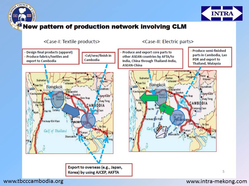
1. “Thailand-Plus-One” is a business model in which Japanese companies operating in industrial clusters in Thailand transfer the labor-intensive parts of their production processes to special economic zones (SEZs) in Cambodia, Laos and Myanmar near their borders with Thailand. 2. The Thailand-Plus-One business model is derived from the fragmentation that have been a feature of world trade and investment since However, it differs from traditional models in that it links on small- and medium-sized cities in border areas. 3. Two factors are helping to turn the Thailand-Plus-One business model into reality. The first is the dwindling attractiveness of labor-intensive production in Thailand due to rising wages and labor shortages in that country. The unemployment rate in Thailand is under 1%, and wages have increased over 30% over the last two years. The second factor is the improvement of political and economic condition of the CLM countries―Cambodia, Laos and Myanmar―as recipients of investment by foreign companies. In recent years their growth rates have exceeded those of the original ASEAN countries, and they are all now making the transition to middle-income status. Another factor that has brought them to the fore as investment targets is the proactive efforts made by their governments to attract foreign companies
 in Cambodia, Laos and Myanmar near their borders with Thailand. 2. The Thailand-Plus-One business model is derived from the fragmentation that have been a feature of world trade and investment since However, it differs from traditional models in that it links on small- and medium-sized cities in border areas. 3. Two factors are helping to turn the Thailand-Plus-One business model into reality. The first is the dwindling attractiveness of labor-intensive production in Thailand due to rising wages and labor shortages in that country. The unemployment rate in Thailand is under 1%, and wages have increased over 30% over the last two years. The second factor is the improvement of political and economic condition of the CLM countries―Cambodia, Laos and Myanmar―as recipients of investment by foreign companies. In recent years their growth rates have exceeded those of the original ASEAN countries, and they are all now making the transition to middle-income status. Another factor that has brought them to the fore as investment targets is the proactive efforts made by their governments to attract foreign companies.")
47
EWEC Complementary Corridors and Routes
Challenges The differences in procedures, regulations and laws between the countries in the corridor Slow changes in administrative reform and protection of domestic markets Lack of effective institutional coordination

48
Useful link www.investincambodia.com www.ccb.com.kh

50
THANK YOU SO MUCH FOR YOUR ATTENTION
Arranged by Mrs. Tui Pakarat-Rutten The Vice President of TBCC H/P:

Similar presentations


 Director Genral National Economic Research.>")
, all in Support of GMS Program on TTF Kazi Matin & Baher El-Hifnawi Workshop on World Bank’s Regional.>")


