Download presentation
Presentation is loading. Please wait.

1
Who Needs New Datums? NGS Says… ftp://ftp.ngs.noaa.gov/pub/marti Marti Ikehara California Geodetic Advisor, Sacramento

2
Outline History/background Current situation Rationale for new datums GRAV-D Program -------------------------------------- Google Earth displays of geodetic control

3
What IS a datum? It is NOT the same (concept) as a “projection”, which controls how maps are represented or “look” on paper or on a screen. It is a reference, a basis, for coordinates, so a datum has an origin and/or ‘zero’. “Underlying” a horizontal datum system is an ELLIPSOID, that represents the global shape of the earth; a DATUM is the ‘continental’ shape as realized with physical marks (passive or active)
 as a projection , which controls how maps are represented or look on paper or on a screen. It is a reference, a basis, for coordinates, so a datum has an origin and/or ‘zero’. Underlying a horizontal datum system is an ELLIPSOID, that represents the global shape of the earth; a DATUM is the ‘continental’ shape as realized with physical marks (passive or active).")
4
ELLIPSOIDS used in the US (More than 60 have been used around the world) CLARKE 1866 (1879 – 1986) a = 6,378,206.4 m 1/f = 294.97869821 GEODETIC REFERENCE SYSTEM 1980 - (GRS 80) (1986 - Present) a = 6,378,137 m 1/f = 298.257222101 WORLD GEODETIC SYSTEM 1984 - (WGS 84) a = 6,378,137 m 1/f = 298.257223563 BESSEL 1841 (1848 – 1879) a = 6,377,397.155 m 1/f = 299.1528128
 CLARKE 1866 (1879 – 1986) a = 6,378,206.4 m 1/f = GEODETIC REFERENCE SYSTEM (GRS 80) ( Present) a = 6,378,137 m 1/f = WORLD GEODETIC SYSTEM (WGS 84) a = 6,378,137 m 1/f = BESSEL 1841 (1848 – 1879) a = 6,377, m 1/f =")
5
The National Geodetic Vertical Datum of 1929 was referenced to 26 tide gauges in the US and Canada

6
The North American Vertical Datum of 1988 is referenced to a single tide gauge in Canada

7
H + H t + V E + V Et 2 + 2 + 1+ 1 ITRF00 (2002.00) Evolution of Geodetic Datums in U.S. from NAD27/NGVD29 to NAD83/NAVD88 to ?/ ? H + V 2 + 1 27, 29 H + V 2 + 1 83(86), 88 H + V E + V O 2 + 1 + 1 83(92), 88 GPS +VELOCITIES (time) H + H t + V E + V O 2 + 2 + 1+ 1 83(07)+HTDP, 88 ?
, 88 H + V E + V O (92), 88 GPS +VELOCITIES (time) H + H t + V E + V O (07)+HTDP, 88 .")
8
EQUIPOTENTIAL SURFACES

10
GEOID09 published in Sept 09 In California, GEOID03 considered 567 bench marks with GPS data (ellipsoid heights), and kept 549 In GEOID09, there were 833 considered; 747 were included, a 36% increase
, and kept 549 In GEOID09, there were 833 considered; 747 were included, a 36% increase")
11
GEOID09 compared to GEOID03 09: teal, good; yellow: State advisor-rejected; red: analysis-rejected 03 (underlying dots): dk blue, kept; orange: rejected
: dk blue, kept; orange: rejected")
12
From Helmer’s article in Winter 09/10 issue of California Surveyor

13
Rationale for new Geodetic Datums Terminology – Horizontal becomes GEOMETRIC – Vertical becomes GEOPOTENTIAL When?2020, if GRAV-D program is complete Why? But why?! 1.Primarily need a better vertical datum for “vertical” data(geoid, ortho ht) not obtained by traditional leveling
 not obtained by traditional leveling.")
14
2009 National Research Council Report “…uniform national standards for FEMA flood maps cannot be met until an improved orthometric height datum and geoid model exist…”

15
Rationale for new Datums Terminology – Horizontal becomes GEOMETRIC – Vertical becomes GEOPOTENTIAL When?2018, if GRAV-D program is complete Why? But why?! 1.Primarily need a better vertical datum for “vertical” data(geoid, ortho ht) not obtained by traditional leveling 2.Geodetic Data collection relies upon navigation (GNSS) satellites orbiting around the mass center of the Earth – NAD83 reference frame/datum is not geocentric
 not obtained by traditional leveling 2.Geodetic Data collection relies upon navigation (GNSS) satellites orbiting around the mass center of the Earth – NAD83 reference frame/datum is not geocentric.")
16
X Z Y Earth-Centered Earth-Fixed (ECEF) Coordinate System Earth Mass Center Greenwich Meridian -X-Y -Z X, Y, Z = 0 X A, Y A, Z A (not NAD83) GRS 80 Ellipsoid
 Coordinate System Earth Mass Center Greenwich Meridian -X-Y -Z X, Y, Z = 0 X A, Y A, Z A (not NAD83) GRS 80 Ellipsoid")
17
Simplified Concept of NAD 83 vs. ITRF00 (or WGS84) 2.2 meters NAD 83 Origin ITRF 00 Origin Earth’s Surface h 83 h 00 Identically shaped ellipsoids (GRS80) a = 6,378,137.000 meters (semi-major axis) 1/f = 298.25722210088 (flattening)
 2.2 meters NAD 83 Origin ITRF 00 Origin Earth’s Surface h 83 h 00 Identically shaped ellipsoids (GRS80) a = 6,378, meters (semi-major axis) 1/f = (flattening).")
18
Rationale for new Datums Terminology – Horizontal becomes GEOMETRIC – Vertical becomes GEOPOTENTIAL When?2018, if GRAV-D program is complete Why? But why?! 1.Primarily need a better vertical datum for “vertical” data(geoid, ortho ht) not obtained by traditional leveling 2.Geodetic Data collection relies upon navigation (GNSS) satellites orbiting around the mass center of the Earth – NAD83 reference frame/datum is not geocentric 3.Earth is not stable in all directions; reference frame must account for this to be as geodetically accurate as possible – NAD83 is not defined to include vertical velocities
 not obtained by traditional leveling 2.Geodetic Data collection relies upon navigation (GNSS) satellites orbiting around the mass center of the Earth – NAD83 reference frame/datum is not geocentric 3.Earth is not stable in all directions; reference frame must account for this to be as geodetically accurate as possible – NAD83 is not defined to include vertical velocities.")
19
Horizontal Velocities, relative to ‘stable’ NA tectonic plate, are reflected in HTDP model

20
Worldwide Tectonic Horizontal Motions

21
CORS Data allows for Monitoring Vertical Crustal Motion Vertical velocities associated with Glacial Isostatic Adjustment (rebound)
")
22
H + H t + V E + V Et 2 + 2 + 1+ 1 ITRF00 (2002.00) Evolution of Geodetic Datums: from NAD27/NGVD29 to NAD83/NAVD88 to ?/ ? H + V 2 + 1 27, 29 H + V 2 + 1 83(86), 88 H + V E + V O 2 + 1 + 1 83(92), 88 GPS +VELOCITIES (time) H + H t + V E + V O 2 + 2 + 1+ 1 83(07)+HTDP, 88 + GRAVITY (geoid model) H + H t + V E + V Et 2 + 2 + 1+ 1 GEOMETRIC (V E +G)[+V Et ] + G t 1 + 1 GEOPOTENTIAL
, 88 H + V E + V O (92), 88 GPS +VELOCITIES (time) H + H t + V E + V O (07)+HTDP, 88 + GRAVITY (geoid model) H + H t + V E + V Et GEOMETRIC (V E +G)[+V Et ] + G t GEOPOTENTIAL.")
23
The Future of Height Mod: GRAV-D Gravity for the Redefinition of the American Vertical Datum GRAV-D –Airborne gravity surveys (taking 10 years) –Coastal areas surveyed first –All USA states and territories –www.ngs.noaa.gov/GRAV-D GOAL: –Orthometric heights-”elevations” – to be good to 2 cm anywhere, anytime with an excellent ellipsoid height from GNSS technology. Currently this takes 3-4 hours at 15-second recording and dual-frequency GPS –Height changes much more easily monitored than by leveling, using new technology – GNSS heights and gravity values –Spot-checking/monitoring gravity changes with portable field units

24
Hawaii Alaska “CONUS” Puerto Rico / Virgin Islands Guam / Northern Marianas American Samoa Planned GRAV-D Coverage

25
NGA funded NRL plane USACE funded As of Jan 2010: 6.7% of planned areas have been flown Status of GRAV-D in early 2010

26
Preliminary GRAV-D Results

27
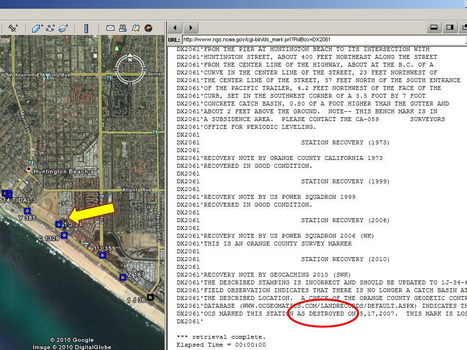
http://www.dot.ca.gov/hq/row/landsurveys /geodetic/geodetic_control.html

35
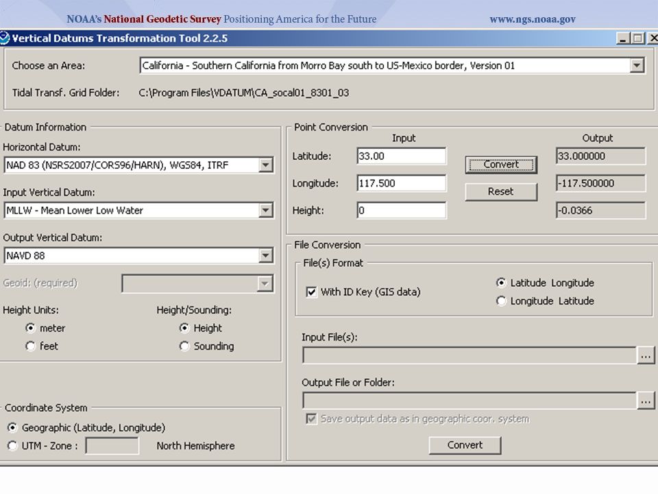
Datums available in VDATUM

36
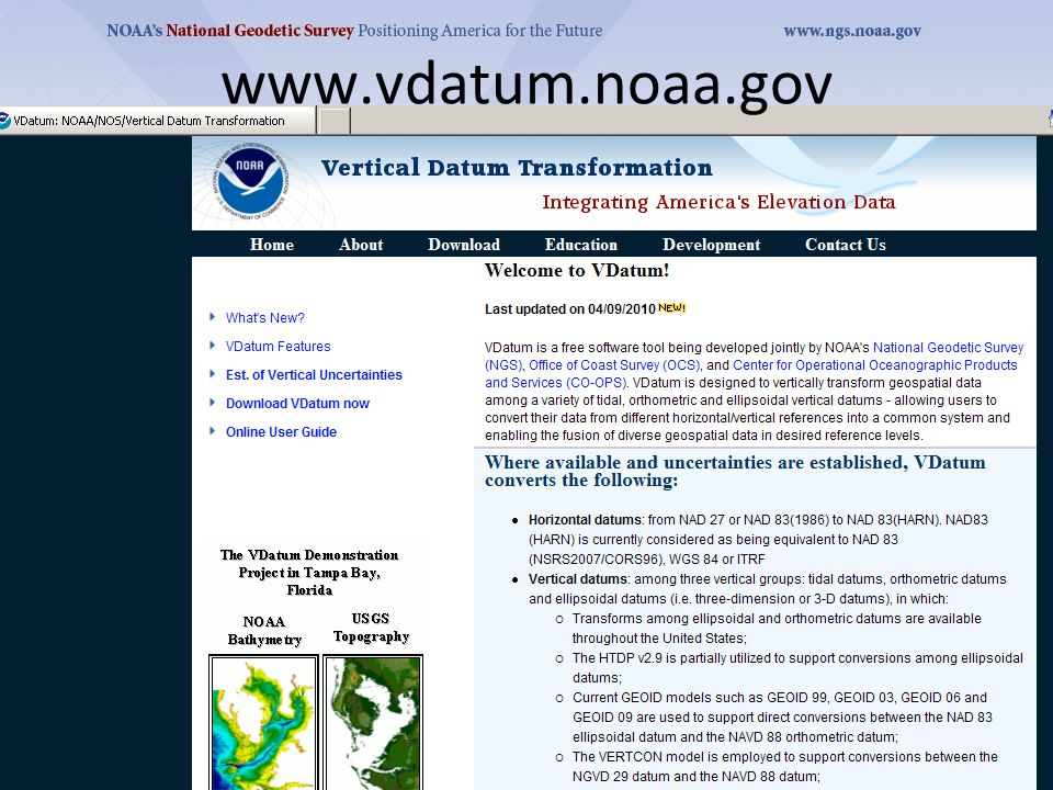
www.vdatum.noaa.gov
39
Caution: Must Convert fr WGS84/ITRF## to NAD83 and then apply GEOID##

41
Anything Else?! Marti.ikehara@noaa.gov 916-227-7325 ftp://ftp.ngs. ftp://ftp.ngs noaa.gov/pub/marti

Similar presentations


 and the Defense Mapping School Reviewed by:____________ Date:_________ Objective:>")


