Download presentation
Presentation is loading. Please wait.

1
OPENING ACTIVITY

2
Indian Subcontinent Geography (South Asia) Instructions: Using page 161-170, find evidence in the section to support each of the following generalizations. A.The terrain of the Indian subcontinent varies widely. B.The Himalayas and the Hindu Kush are important to the subcontinent’s water supply. C.Farming is an important way of life for millions of people on the subcontinent. D.Geographic barriers influenced the development of different regional cultures on the subcontinent. E.Rivers play many vital roles in the life of South Asia.

3
South Asia/Indian Subcontinent

4
Subcontinent separate part of continent: a large area that is an identifiably separate part of a continent isolated by geographic features India - 2nd to China in population Nations India, Pakistan, Bangladesh, Nepal, Bhutan Island Nations: Sri Lanka, Republic of Maldives Transition: Afghanistan

5
A subcontinent is a large landmass that is smaller than a continent.A subcontinent is a large landmass that is smaller than a continent. The Indian subcontinent was formed when pieces of the landmass of Gondwanaland collided with Laurasia.The Indian subcontinent was formed when pieces of the landmass of Gondwanaland collided with Laurasia. The ensuing collision created the Himalaya and Hindu Kush mountains.The ensuing collision created the Himalaya and Hindu Kush mountains. Although people were able to travel through passes in these mountains, its settlers developed a unique culture.Although people were able to travel through passes in these mountains, its settlers developed a unique culture. The Indian Subcontinent

6
How Indian Subcontient Formed Continental-Continental Convergence Continental-Continental Convergence Continental-Continental Convergence

9
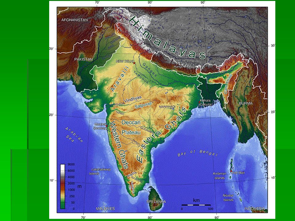
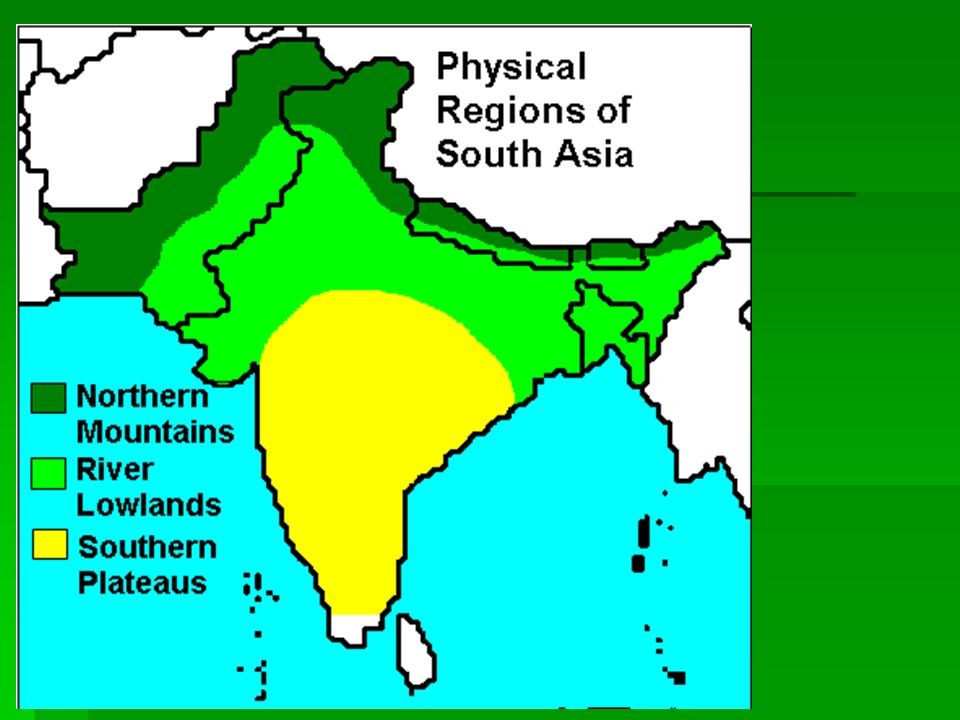
a. The Terrain of the Indian subcontinent varies widely. Northern Mountain: Himalayas (Mt. Everest), Hindu Kush Khyber Pass: mountain through Hindu Kush = traders & invaders Kashmir : mountain valley – farming & herding - song Mineral resources – lacks oil for industry Rain shadow effect
, Hindu Kush Khyber Pass: mountain through Hindu Kush = traders & invaders Kashmir : mountain valley – farming & herding - song Mineral resources – lacks oil for industry Rain shadow effect.")
10
Rain Shadow

11
The Himalaya Mountains stretch 1,500 miles from east to west.The Himalaya Mountains stretch 1,500 miles from east to west. Many of the world’s highest mountains are in the Himalayas.Many of the world’s highest mountains are in the Himalayas. At least 50 of the mountains are more than 5 miles high, including Mt. Everest.At least 50 of the mountains are more than 5 miles high, including Mt. Everest. To the northwest of the continent lie the Hindu Kush Mountains.To the northwest of the continent lie the Hindu Kush Mountains. Although smaller in area than the Himalayas, the Hindu Kush are nearly as high and rugged.Although smaller in area than the Himalayas, the Hindu Kush are nearly as high and rugged. The Arabic word kush means “death.”The Arabic word kush means “death.” Northern Mountains

12
In between the northern mountains lie many remote valleys.In between the northern mountains lie many remote valleys. Through these valleys flow the headwaters of many of the subcontinent’s rivers.Through these valleys flow the headwaters of many of the subcontinent’s rivers. People in these isolated valleys developed their own ways of life.People in these isolated valleys developed their own ways of life. In the Kashmir Valley, goats produce a fine wool called cashmere.In the Kashmir Valley, goats produce a fine wool called cashmere. Mountain Valleys

14
a. The Terrain of the Indian subcontinent varies widely. Northern Plains/Indo-Gangetic Plain Pakistan to India to Bangladesh Rivers: Indus, Ganges, Brahmaputra Farming=Densely populated Thar Desert: western end of plains = nomads Mineral resources – lacks oil for industry

16
a. The Terrain of the Indian subcontinent varies widely. Deccan Plateau Surrounded by Ghats and Vindhya mountains Triangular, high, flat land, rivers, water harder to find ½ of South Asia Millions of tiny farms rely on monsoons

20
b. The Himalayas and the Hindu Kush are important to the subcontinent’s water supply. Melting snow is the source of streams that feed river system

22
c. Farming is an important way of life for millions of people on the subcontinent. ¾ are farmer Indo-Gangetic Plain densely populated Monsoons: Deccan Plateau relies on the monsoons Key to life, wet and dry (see handout) see handoutsee handout Ganges River Delta (Bay of Bengal) Ganges, Brahmaputra, Meghna rivers Bangladesh Densely populated Below sea level Cyclones
 see handoutsee handout Ganges River Delta (Bay of Bengal) Ganges, Brahmaputra, Meghna rivers Bangladesh Densely populated Below sea level Cyclones.")
23
Back

24
Some people consider monsoon forecasts the most important weather predictions on earth.Some people consider monsoon forecasts the most important weather predictions on earth. The monsoon is a seasonal wind that dominates the climate of South Asia.The monsoon is a seasonal wind that dominates the climate of South Asia. The word monsoon means “season” in Arabic.The word monsoon means “season” in Arabic. Two monsoons define the seasons in South Asia: the wet monsoon of summer and the dry monsoon of winter.Two monsoons define the seasons in South Asia: the wet monsoon of summer and the dry monsoon of winter. Monsoons

25
Bay of Bengal

26
Because of the rich soil on the delta formed by the Ganges and Brahmaputra Rivers, Bangladesh is one of the most densely populated nations in the world.Because of the rich soil on the delta formed by the Ganges and Brahmaputra Rivers, Bangladesh is one of the most densely populated nations in the world. Because much of the land is barely above sea level, seasonal flooding is common.Because much of the land is barely above sea level, seasonal flooding is common. In addition, fierce tropical cyclones sweep in from the Bay of Bengal every five to seven years.In addition, fierce tropical cyclones sweep in from the Bay of Bengal every five to seven years. These storms have a devastating effect on the people in Bangladesh.These storms have a devastating effect on the people in Bangladesh. Flooding and Storms

28
Back

29
d. Geographic barriers influenced the development of different regional cultures on the subcontinent. Mountains: separate and isolate Hindu Kush, Himalayas, Ghats, Vindhya Cultural diversity Separate people into regional and local groups Food, clothing Language India: 15 official languages, 700 dialects Hindi: most widely spoken English Religion: Hinduism, Islam, Buddhism, Christianity, Sikhism, Jainism, Zoroastrianism 3 Migrations: 1. other parts of Asia, 2. Middle East, 3. Europe

31
Cost of Living In India Cost of Living In India

33
There are more than 80 recorded ways to wear a sari The most common style is for the sari to be wrapped around the waist, with the loose end of the drape to be worn over the shoulder, baring the midriff However, the sari can be draped in several different styles, though some styles do require a sari of a particular length or form

38
e. Rivers play many vital roles in the life of South Asia Essential to life = farming and religion Ganges holiest river to Hinduism Supported earliest civilizations of the region Ganges River delta/Delta on the Bay of Bengal = fertile supports life

Similar presentations