Download presentation
Presentation is loading. Please wait.

1
Logical / Physical SIGIZC Cycle SIGIZC Quality Control + Metadata References Diverse Data Sources Interoperability Scientific Spatial Data Infrastructure Marine/Terrestrial Data Indicators International Referneces : Marine Data Model Biodiversity Data Model Other… Data interchange Standards

2
SIG Desktop Remote Acces Web Web Map Service -Data Download -View and query -Analysis WWW Ethernet GIS Server File/Image Server DBMS Server RELATIONAL DBMS GeoInfo. Alphanumeric Images WMS WFS Open Geospatial Consortium Standards SIGIMEDEA Data Model Scientific Spatial Data Infrastructure for GIZC INSPIRE SIGIZC Arquitecture International Referneces : Marine Data Model Biodiversity Data Model Other…

3
Web Map Services 1. Metadata Explorer 2. Cartographic Viewer GIS Desktop SIGIZC SIGIZC Cycle Remote Data AccesLocal Acces Heavy DB Clients Thin DB Clients

4
GIS Data documented using Metadata Standards ISO 9.115, OGC The user can search data directly using the a metadata management tool : SIGIZC : Searching Data.. Or go directly to view or download data using a thematic index of data structured in four topics : Environmental Variable ICMZ AreaResearch ProjectGeographic Location The GIS database has a thematic structure in 20 categories using the same model that propose the INSPIRE initiative (Infrastructure for Spatial Information in Europe) of the European Union WMS/WFS services have been developed in the context of INSPIRE, compliant with INSPIRE principles and Open GIS Consortium standards. In practice, this means that the layers can be viewed through any Web Mapping Service Client (WMS Standalone or Web viewer, ESRI ArcGIS). Metadata are also Available.INSPIRE Open GIS Consortium The Data is indexed in one or more ICMZ areas : Litoral Global Change Biodiversity Quality and Emergence Operational Oceanography New Marine Technologies Socioeconomic Analyst The data mantain information about the research project that belong
 of the European Union WMS/WFS services have been developed in the context of INSPIRE, compliant with INSPIRE principles and Open GIS Consortium standards. In practice, this means that the layers can be viewed through any Web Mapping Service Client (WMS Standalone or Web viewer, ESRI ArcGIS). Metadata are also Available.INSPIRE Open GIS Consortium The Data is indexed in one or more ICMZ areas : Litoral Global Change Biodiversity Quality and Emergence Operational Oceanography New Marine Technologies Socioeconomic Analyst The data mantain information about the research project that belong.")
5
SIGIZC : Data Viewer Google Earth / Google Maps

6
SIGIZC : Map Viewer

7
DEDUCE INDICATORS

8
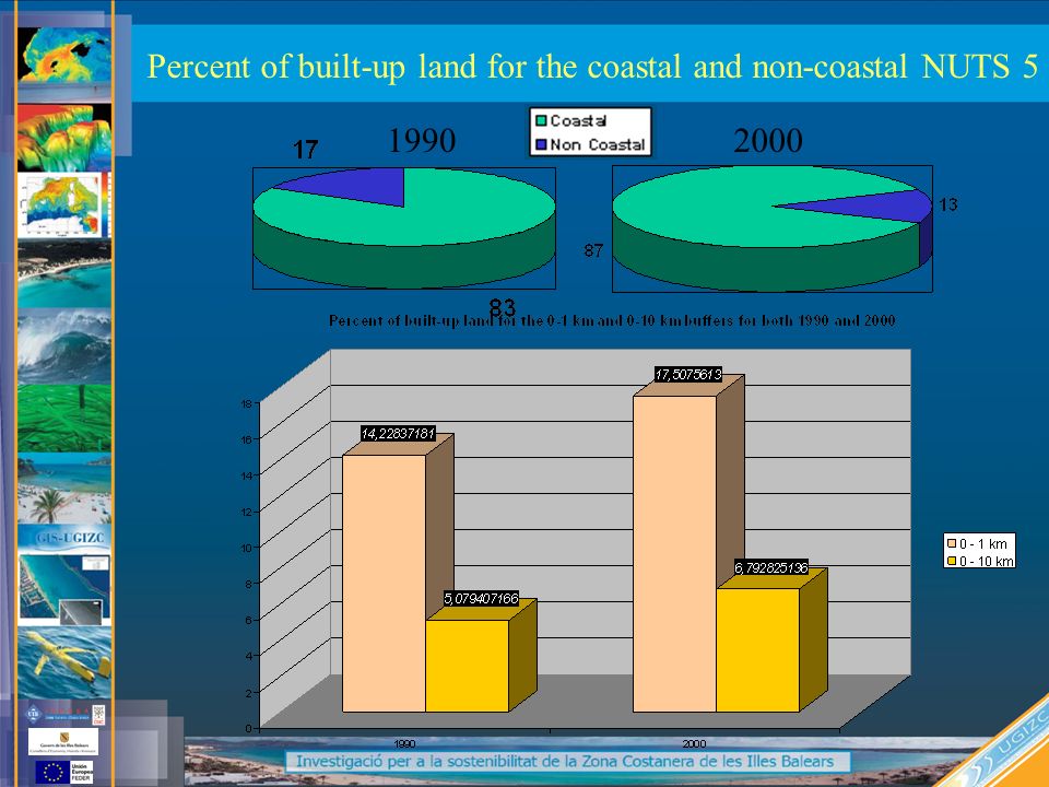
Percent of built-up land for the coastal and non-coastal NUTS 5

9
19902000
10
Demand for property on the coast

Similar presentations


>")
>")


