Download presentation
Presentation is loading. Please wait.

1
WMO Climate and Water Department WMO WIS Common Alerting Protocol (CAP, X.1303) Implementation Workshop 7 – 8 April 2011, Geneva, Switzerland Hydrology and Water Resources Programme WMO CAP and Flood Forecasting
 Implementation Workshop 7 – 8 April 2011, Geneva, Switzerland Hydrology and Water Resources Programme WMO CAP and Flood Forecasting")
2
Extreme event Disaster Bad land use planning and elevated exposure Lack of information and preparedness Flood Risk mitigation: from theory to practice Flood Forecasting IWRM, IFM, Land use planning, Basin Management Early warnings, emergency plans, outreach and education

3
Response to floods Pre-flood During flood Post-flood CFMC coordination Population activities Alert

4
Flood types Riverine floods Pluvial floods Flash floods Debris and mud flows Glacial lake outburst Coastal flooding Storm surges Ground water Lake overflows Ice jams Dam failure Levee breaches

6
FFGS Flash Flood Guidance System Implemented in Central America as the CAFFG system (operational since 2004) Prospectus available at http://www.wmo.int/pages/prog/hw rp/documents/FFGS4-May- 2007.pdf http://www.wmo.int/pages/prog/hw rp/documents/FFGS4-May- 2007.pdf Joint Proposal by WMO (CHy and CBS) in collaboration with HRC, USAID and US NWS Designed to be incorporated into NMHS operations and used along with other available data, systems, tools, and local knowledge to aid in determining the near-term risk of a flash flood in small streams and basins. For more information: ATyagi@wmo.int

7
Definition Used with meteorological forecasts and nowcasts of same-duration rainfall over these basins, leads to the estimation of flash flood threat (the amount of rainfall of a given duration in excess of the corresponding flash flood guidance value) for these small basins. FFG: Amount of rainfall of a given duration over a small basin needed to create minor flooding (bankfull) conditions at the outlet of the basin. Calculate diagnostic indices used to evaluate the potential for flash flooding
 conditions at the outlet of the basin. Calculate diagnostic indices used to evaluate the potential for flash flooding.")
8
FFGS - Implementation Data, Communications, and Data Analyses Center Regional Centers Data, Communications, and Data Analyses Center NMHS Flash flood warnings

9
Community Flood Management Programme (CFMP) in South Asia: Succesfully implemented and tested in the 2004 floods Implementing institutions: Bangladesh Unnayan Parishad (BUP) Dhaka Institute for Resource Management and Economic Development (IRMED), New Delhi Jalstrot Vikas Sanstha (JVS), Kathmandu Pilot Phase (Bangladesh, India, Nepal) - WMO/GWP APFM
 in South Asia: Succesfully implemented and tested in the 2004 floods Implementing institutions: Bangladesh Unnayan Parishad (BUP) Dhaka Institute for Resource Management and Economic Development (IRMED), New Delhi Jalstrot Vikas Sanstha (JVS), Kathmandu Pilot Phase (Bangladesh, India, Nepal) - WMO/GWP APFM")
10
CFMP Pilot phase: the purposes Assemble information on community-level coping strategies emplyed traditionally through interactions with the people Analyze flood management activities and practices at the community level Assess the community level and magnitude of perception of flood as a risk Prepare a community flood management manual

11
APFM Project Objectives: From concept to field demonstration Objective 1: To provide support for the adoption of an integrated approach to flood management Objective 2: To provide Advocacy and Capacity Building for Integrated Flood Management (Tools, Trainings, Presentation Material) Objective 3: To Provide Support for Field Demonstration Projects Objective 4: Provide Strategic advice on flood management through a HelpDesk
 Objective 3: To Provide Support for Field Demonstration Projects Objective 4: Provide Strategic advice on flood management through a HelpDesk")
12
The need for standards Sharing of hydrological data is somewhat ad-hoc, based largely on ad-hoc formats, CSV files and FTP Leads to very inefficient (or non- existent) transfer and sharing of data Sharing requires a lot of transformation effort on the behalf of the data requestor –Parse different file formats –Understand the concepts –Metadata is often limited or non- existent, requiring follow up conversations : JAN RESERVOIR DATA 900 AM CST THU MAR 28 1985.B JAN 0328 C DH06/HP/HW/PP/QT : STN ID POOL TAILW PCPN DISCH K CFS JSNM6 295.71 / 259.51 / 0.50 / 4.300 : BARNETT DNNM6 410.1 / 330.3 /.31 / : BAY SPRINGS L&D ABEM6 190.1 / 163.6 /.17 / : ABERDEEN L&D CBUM6 163.5 / 137.1 /.39 / : COLUMBUS L&D ARKM6 210.1 / /.07 /.650 : ARKABUTLA SRDM6 242.8 / /.10 /.250 : SARDIS ENDM6 235.1 / /.37 /.100 : ENID GRNM6 197.6 / /.70 /.100 : GRENADA BMDA4 / / 0.00 / 6.393 : BLAKELY, AR DGDA4 / /.10 / 2.634 : DEGRAY, AR NARA4 / / 0.00 / 1.244 : NARROWS, AR.END
 transfer and sharing of data Sharing requires a lot of transformation effort on the behalf of the data requestor –Parse different file formats –Understand the concepts –Metadata is often limited or non- existent, requiring follow up conversations : JAN RESERVOIR DATA 900 AM CST THU MAR B JAN 0328 C DH06/HP/HW/PP/QT : STN ID POOL TAILW PCPN DISCH K CFS JSNM / / 0.50 / : BARNETT DNNM / /.31 / : BAY SPRINGS L&D ABEM / /.17 / : ABERDEEN L&D CBUM / /.39 / : COLUMBUS L&D ARKM / /.07 /.650 : ARKABUTLA SRDM / /.10 /.250 : SARDIS ENDM / /.37 /.100 : ENID GRNM / /.70 /.100 : GRENADA BMDA4 / / 0.00 / : BLAKELY, AR DGDA4 / /.10 / : DEGRAY, AR NARA4 / / 0.00 / : NARROWS, AR.END")
13
The need for harmonisation A number of initiatives exist to develop standards for water observation data: –WaterML1.0, 1.1 –WDTF, WOML –CAP –XHydro –UK Environmental Agencies time series transfer format –SANDRE –...; A lot of commonalities exist between the standards –Partial duplication of effort –Inconsistencies across the standards –Hard to re-use tools Potential for a harmonised, re-usable information model –Define common semantics of concepts

14
Use of CAP for flood forecasting Link forecasters and users Bridging between hydrologist and disaster managers Hydro and meteo alerts at once Quantifying the level of risk Making it undersatndable in different contexts Not yet widely adopted (national standards prevail)
")
23
Thank you

24
A common situation Need flow data! Hmm maybe Don can help… *RING RING* Hi Don, I need some upper Derwent flow readings for my geochemical model. Any ideas? Don Hmm, Ive got one site. Ill send it through… 10 minutes… To: Jack 01/02/09, 3.2, 3, 1 01/02/09, 3.1, 3, 1 10 minutes… *RING RING* Ok. Got the data. Where is the site located? Oh, its at laughing jack bridge. Coordinates? Ummm. (papers shuffle) 147.123 -41.588 What reference system?? I think its GDA94 Ok. What sensor is used? Its calculated from the stream gauge reading using a rating curve.. Oh…how accurate is that? Umm...... DON? Hydro Jack *CLICK*
 What reference system . I think its GDA94 Ok. What sensor is used. Its calculated from the stream gauge reading using a rating curve.. Oh…how accurate is that. Umm DON. Hydro Jack *CLICK*.")
25
The future? Hydro Jack Laughing Jack Bridge 147.123 -41.588 (AGD66) Upper Derwent River Observed properties: River level, River Flow, Rainfall River Flow --Measured by Sontek Acoustic Doppler Sensor (ID232) --Accuracy: +/- 0.02 --Installed: 01/04/2012 Need flow data!
 Upper Derwent River Observed properties: River level, River Flow, Rainfall River Flow --Measured by Sontek Acoustic Doppler Sensor (ID232) --Accuracy: +/ Installed: 01/04/2012 Need flow data!.")
26
Italy White Dati non disponibili Dati non disponibili Green Nessun AvvisoNessun Avviso Yellow Potenzialmente pericoloso Potenzialmente pericoloso Orange Pericoloso Pericoloso Red Molto pericolosoMolto pericoloso Vento Temperature massime estreme Pioggia Temperature minime estreme Neve/Ghiaccio Eventi costieri Temporali Incendi boschivi Nebbia Valanghe Nessun Avviso Avvisi per temporali isolati e/o vento forza 7 (28-33 nodi) Avvisi per temporali diffusi e/o vento forza 8 (34-40 nodi) e oltre
 Avvisi per temporali diffusi e/o vento forza 8 (34-40 nodi) e oltre")
27
Hydrology Domain Working Group A joint working group of the OGC and WMO constituted as an OGC Domain Working Group. Brings together interested parties to develop and promote the technology for greatly improving the way in which water information is described and shared. Co-chaired by representatives nominated by the OGC TC and the World Meteorological Organisations (WMO) Commission for Hydrology (CHy). Current Co-Chairs: David Lemon (CSIRO), Ilya Zaslavsky (SDSC) and Ulrich Looser (GRDC) > 50 Participants, > 30 Organisations
 Commission for Hydrology (CHy). Current Co-Chairs: David Lemon (CSIRO), Ilya Zaslavsky (SDSC) and Ulrich Looser (GRDC) > 50 Participants, > 30 Organisations.")
28
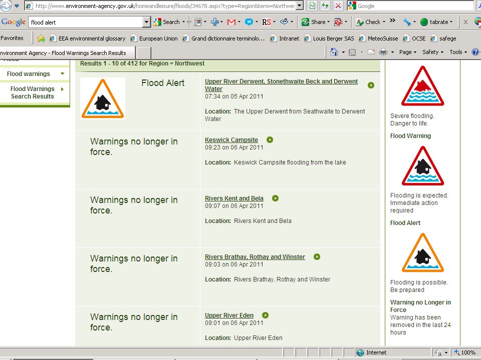
CAP levels Extreme - Extraordinary threat to life or property Severe - Significant threat to life or property Moderate - Possible threat to life or property Minor – Minimal to no known threat to life or property Unknown - Severity unknown

29
Missi on to support countries in the integrated management of floods within the overall framework of Integrated Water Resources Management. IFM aims at: Maximizing the net-benefits from floodplains and Minimizing losses of life Associated Programme on Flood Management

30
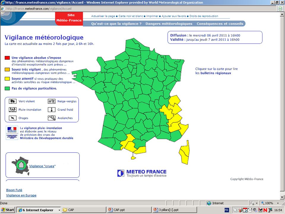
Vigliance Crues FR Rouge : Risque de crue majeure. Menace directe et généralisée de la sécurité des personnes et des biens. Orange : Risque de crue génératrice de débordements importants susceptibles davoir un impact significatif sur la vie collective et la sécurité des biens et des personnes. Jaune : Risque de crue ou de montée rapide des eaux n'entraînant pas de dommages significatifs, mais nécessitant une vigilance particulière dans le cas d'activités saisonnières et/ou exposées. Vert : Pas de vigilance particulière requise.

31
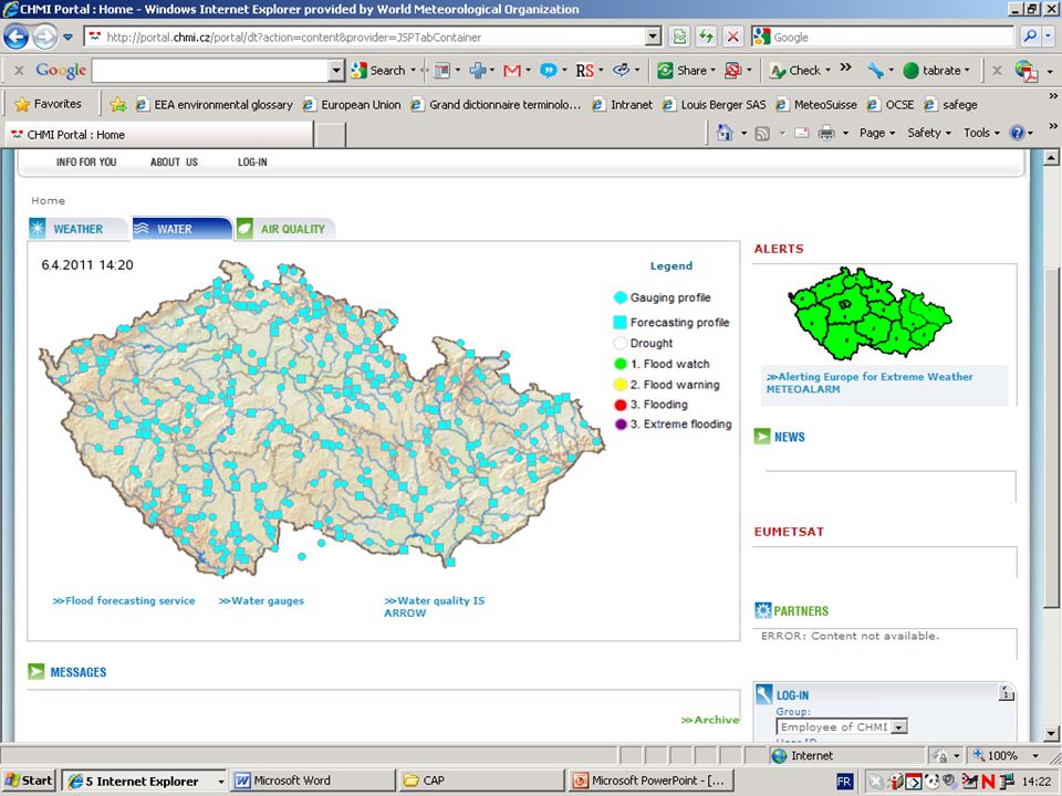
EFAS S (severe) Very high probability of flooding, potentially severe flooding expected. H (high) High possibility of flooding, bankfull conditions or higher expected. M (medium) Water levels high but no flooding expected. L (low) Water levels higher than normal but no flooding expected
 High possibility of flooding, bankfull conditions or higher expected. M (medium) Water levels high but no flooding expected. L (low) Water levels higher than normal but no flooding expected.")
32
Hydrological observations Measurements of –Water level, –Water temperature, –Discharge, –Sediment, –Water quality –... Different sampling techniques (in-situ, laboratory etc.) Why do people want to share hydrological observations? –Provide data to national systems (AWRIS, CUAHSI) –Share data between agencies Hydro company to local water authority Researchers (learning hydrology, modelling) –Other domains Climatology Oceanography Meteorology
 Why do people want to share hydrological observations. –Provide data to national systems (AWRIS, CUAHSI) –Share data between agencies Hydro company to local water authority Researchers (learning hydrology, modelling) –Other domains Climatology Oceanography Meteorology.")
Similar presentations


 International Task Team (ITT) Working Session Rama Gardens Hotel, Bangkok, Thailand September 25, 2006 Bangladesh.>")


 Task.>")


