Download presentation
Presentation is loading. Please wait.

1
Atmospheric Stability & Instability
How does is relate to cloud development and precipitation?

2
Terms & Concepts to Know
Evaporation: liquid to gas – Cools the AIR Condensation: gas to liquid – Warms the AIR Rising air: Cools and expands Sinking Air: Warms by compression Lapse Rate: Rate of temperature change for a rising parcel of air Lapse rate for Unsaturated air is 5° /1,000’ Lapse rate for Saturated air is 3° /1,000’

3
Adiabatic Temperature Changes
An adiabatic process is one in which no heat is exchanged between the air parcel and the surrounding air As air Expands – it always cools As air is compressed, it always warms

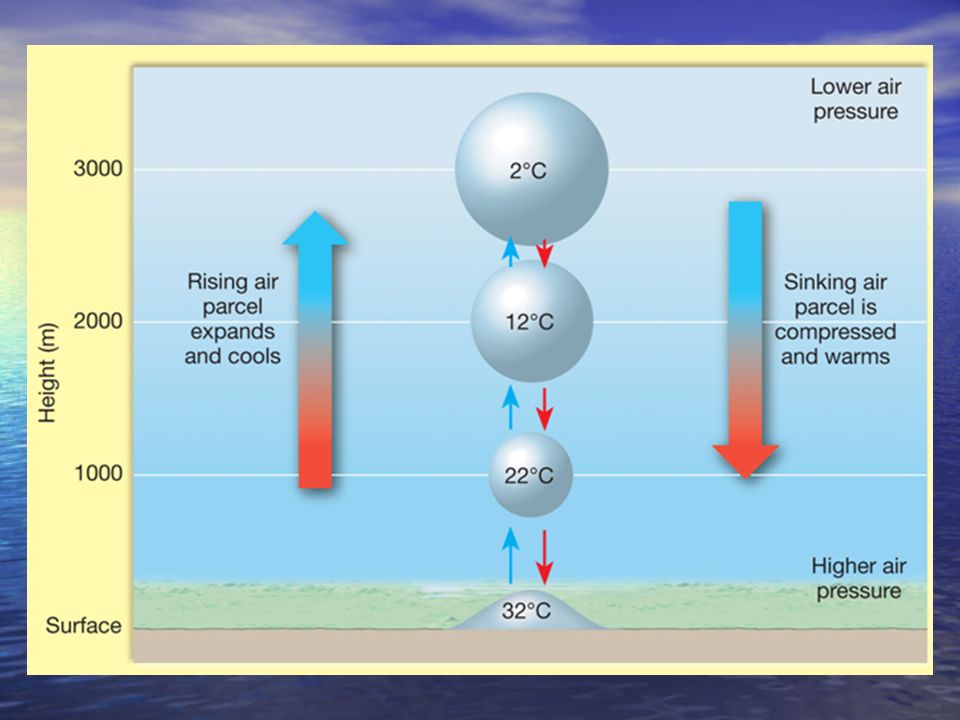
5
What actually happens within a rising, closed “air parcel”
When an air parcel RISES , the Temperature decreases as it expands The rate of temperature decline is 5 ° per 1,000’ But when the air Temp=dewpoint temp , the rate of decline is only 3° /1,000’ because as the water vapor condenses into droplets, it gives off some heat energy which slows the rate of temperature decline RH: 100% RH: 85% RH: 70%

6
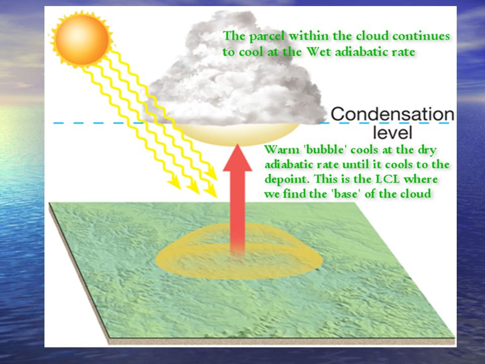
Adiabatic Temperature Changes
Adiabatic cooling and condensation: Cooling occurs when air moves up and it expands (and cools) Unsaturated air cools at a rate of 5° F/1000’ this is called the dry adiabatic rate. Condensation is triggered when air rises high enough to become saturated (the dewpoint temperature) This is called the Lifting Condensation Level (LCL) When air rises above the lifting condensation level, the rate at which it cools is reduced. This slower rate of cooling is called the wet adiabatic rate which is about 3° F/1000’
 Unsaturated air cools at a rate of 5° F/1000’ this is called the dry adiabatic rate. Condensation is triggered when air rises high enough to become saturated (the dewpoint temperature) This is called the Lifting Condensation Level (LCL) When air rises above the lifting condensation level, the rate at which it cools is reduced. This slower rate of cooling is called the wet adiabatic rate which is about 3° F/1000’")
7
Stability and Instability
This refers to the temperature ‘profile’ of the Atmosphere (NOT the Parcel!) REMEMBER – as you MOVE UP from the surface, the temperature DECREASES in the Troposphere. The Temp. ‘profile’ can however, VARY from day to day! Some days it might only be 2°/1,000’, and other days, might be 6° or more per 1,000’ !
 REMEMBER – as you MOVE UP from the surface, the temperature DECREASES in the Troposphere. The Temp. ‘profile’ can however, VARY from day to day! Some days it might only be 2°/1,000’, and other days, might be 6° or more per 1,000’ !")
8
An air parcel that is Warmer than its surroundings will always Rise…
As long as the air within the rising parcel is warmer than its surroundings, it will continue to rise – just like a hot air balloon. BUT once the air within the rising (and still cooling) air parcel gets colder than it surroundings, it will stop rising, and will want to sink!
 air parcel gets colder than it surroundings, it will stop rising, and will want to sink!")
9
INTSTABILITY… Instability : Warm air at the surface and cold air above allows air parcels that are warm at the surface to rise…

10
Stable Conditions Stability: Cool air at the surface with relatively warm air aloft will STOP air parcels from rising!

11
IN GENERAL… Instability Exists with warm air at the surface and cold air aloft. This allows air parcels that are warm at the surface to rise, cool, form clouds and eventually precipitation Stability: Exists with cool air at the surface but relatively Warmer’ air aloft. This inhibits surface parcels from rising and can normally force any rising parcel to return to lower levels – or not rise at all!

12
Adiabatic Temperature Changes EXAMPLES…

13
Adiabatic Temperature Changes
Adiabatic cooling and condensation: When air parcels move up, it expands and cools Unsaturated air cools at a rate of 5° F/1000’ this is called the dry adiabatic rate. Condensation is triggered when air rises high enough to reach its saturation point (the dewpoint) and clouds form, this is called the lifting condensation level (or LCL) When air ascends above the lifting condensation level, the rate at which it cools is reduced since condensation warms the air slightly. The slower rate of cooling is called the wet adiabatic rate (because the air is saturated), which is about 3° F/1000’
 and clouds form, this is called the lifting condensation level (or LCL) When air ascends above the lifting condensation level, the rate at which it cools is reduced since condensation warms the air slightly. The slower rate of cooling is called the wet adiabatic rate (because the air is saturated), which is about 3° F/1000’")
14
Rising Air Parcels that are Cooler than Environment Tends Toward Stability
*** STABLE air does NOT allow warm air parcels to rise. An air parcel that starts to rise (by whatever mechanism) cools at the DRY ADIABATIC rate that ends up colder than its surroundings will be forced back down (5° F/ 1000’)
 cools at the DRY ADIABATIC rate that ends up colder than its surroundings will be forced back down. (5° F/ 1000’)")
15
WARM SURFACE – COLD AIR ALOFT
Air Cools at Dry Adiabatic Rate until Reaching Dew Point Then Cools at Wet Adiabatic Rate *** Environment -12°C Environment -4°C (3° F/ 1000’) (5° F/ 1000’)
 (5° F/ 1000’)")
16
Thunderstorm Development

17
Processes That Lift Air
Orographic Lifting Frontal Wedging Surface Convergence Differential Heating .

18
Orographic Lifting Orographic lifting occurs when elevated terrains, such as mountains, act as barriers to the flow of air Adiabatic cooling can generate clouds and copious precipitation. Many of the wettest places in the world are located on windward mountain slopes When air reaches the leeward side, much of its moisture has been lost – and/or downslope winds warm and dry the air!

19
Localized Orographic Lifting – KAUAI
Kauai has over 450” / year in some of the high mountains on Windward (East) side of the mountain drops off to less than 10” on west side!
 side of the mountain drops off to less than 10 on west side!")
20
Strong Orographic Lifting during the Winter Season
SFO Winter Storms can often bring 5 to 10 feet of snow at a time to the Sierras, while very little falls in Nevada!

21
Strong Orographic Lifting during the Winter Season
Just as astonishing is how Temperatures are forced to rise on the Leeward side of the southern Sierras east of Los Angeles. The hottest temperature in the US are typically found in Death Valley where less than 3” of rains during an entire year – some years there is less than 1”! Death Valley

22
Frontal Wedging Warm Front
When masses of warm and cold air collide, producing fronts, cooler, less denser air acts as a barrier over which the warmer, less dense air rises This process is called frontal wedging. Warm Front Shallow gradual slope

23
Frontal Wedging Cold Front
Cold air pushing into a warm Air mass pushes against the warm air - sometimes at a powerful, violent rate triggering strong Thunderstorms Cold Front Sharp steep slope

24
Uplifting by Convergence
Convergence over Florida Clouds, showers & thunderstorms forming inland as afternoon sea breeze from Atlantic and Gulf of Mexico collide over the interior of the state JAX TPA FMY MIA

25
Uplifting by Convergence
Converging horizontal air flow results in upward movement. Convergence can come in many other situations as well! TPA Warm moist Warm moist Colliding air forced upward MIA

26
Localized Convective Lifting Differential Heating
Unequal surface heating causes localized ‘pockets’ of air to rise

27
Differences in Terrain & type of ground cover & even cloud cover results in ‘bubbles’ of warmer air near the surface These ‘bubbles’ of warm air – called thermals – begin to rise

29
The Critical Weathermaker: Atmospheric Stability
Stable air resists vertical movement Unstable air rises due to buoyancy Environmental lapse rate is the actual temperature of the ‘fee’ atmosphere and is measured at various heights in the atmosphere (and it surrounds our ‘parcel’) Very cold aloft with warm air at the surface is VERY Unstable The bigger this differential – the more unstable!
 Very cold aloft with warm air at the surface is VERY Unstable The bigger this differential – the more unstable!")
30
Stability and Daily Weather
How stability changes: Instability is enhanced by the following: Intense warming of the lowest layer of the atmosphere Heating of an air mass from below General upward movement of the air caused by orographic lifting, frontal wedging, and / or convergence Radiation cooling of the cloud tops (frequently occurs over the tropical ocean in the summer)
")
31
Stability and Daily Weather
How stability changes: Stability is increased by the following: Radiation cooling of Earth’s surface after sunset Cooling of an air mass from below as it traverses a cold surface (ex: air moving over colder water) General subsidence (sinking) is a general, downward airflow from aloft and results in increased stability with clear, blue, cloudless skies
 General subsidence (sinking) is a general, downward airflow from aloft and results in increased stability with clear, blue, cloudless skies.")
32
Stability and Daily Weather
Temperature changes and stability: When otherwise very stable but somewhat moist air manages to cool by radiational cooling of the layer close to the ground, widespread, ‘radiation fog’ often forms In winter, air can become sufficiently unstable when cold, dry air passes over a warm, wet surface to produce showers. For example, very cold air passing over the relatively warmer Great Lakes, can often produce lake effect snow – especially in early winter

Similar presentations