Download presentation
Presentation is loading. Please wait.

1
EXPERIENCES WITH WFS-T IN THE DUERO INFORMATION SYSTEM Editing geometries and tracking changes Javier Fernández Pereira WISE TG Meeting - Madrid, June 7th 2010 Good morning
![]()
2
CONTENTS INTRODUCTION PROPOSED ARCHITECTURE. ALTERNATIVES SOME RESULTS
Server software Client software SOME RESULTS Editing User Authentication Change History CONCLUSIONS FURTHER DEVELOPMENTS

3
MIRAME-IDEDuero http://www.mirame.chduero.es INTRODUCTION
He puesto una secuencia de 6 pantallazos que aparecen cada segundo The Duero Information system aims to support the development of the new RBMP. Besides, it intends to be basis for the technical work in the River Basin Authority. It is available through the link MÍRAME-IDEDuero is a geonode within the Spatial Data Infrastructure, providing the tematic information the CHD is responsible for. It is also a tool being used for the public participation processes.

4
INTRODUCTION BACKGROUND: Capabilities already available within the Duero Information System: Map service (WMS) : Feature service (WFS): Get capabilities service: Catalog service (CSW) : .es/geonetwork/srv/es/csw Nomenclator service (WFS-G): So far the Available services are: Visualization services download services Calagog services and Nomenclator services BUT… TO THE DATE, there are no editing capabilities. 4
: Get capabilities service: service=CSW&request=GetCapabilities&version= Catalog service (CSW) : .es/geonetwork/srv/es/csw. Nomenclator service (WFS-G): So far the Available services are: Visualization services. download services. Calagog services and. Nomenclator services. BUT… TO THE DATE, there are no editing capabilities. 4.")
5
BUT CHANGES NOT REGISTERED
INTRODUCTION CURRENT SITUATION ALFANUMERIC DATA Registered users Edition capabilities Change approval workflow Change history GEOGRAPHIC DATA Free access Online edition not available Manual Workaround: BUT CHANGES NOT REGISTERED Workaround: Export layer, edit in desktop, insert in DB Information System: Alphanumeric + Geographic Allows alphanumeric editing Registered users Change approval workflow Change history Regarding geographic information Can’t edit layers in DB Export layer, edit in desktop, Import layer

6
INTRODUCTION GOALS ENHANCE MIRAME IDE-DUERO SO THAT USERS CAN EDIT GEOGRAPHIC INFORMATION AS NEEDED GUARANTEE DATA INTEGRITY User authentication Change approval workflow Change history And OpenSource… SO, Due to the requirements to accomplish the current directives: WFD, INSPIRE and coming into force of New Directives: floods, marine strategy, priority substances) there is a need of continuos uploading of data. With this on view and in agreement with the developmento of WISE as a distributed system. The objectives for this proyect is, basically /enjéis/ 1. Enhance MIRAME IDE-Duero so that users can edit geographic information as needed, in the same way they edit alphanumeric data. By taking into account that it must be a service that guarantees data integrity including topological relationships between geographic features. To assure this, only authentified editors can implement changes and every change must be subject to QA/QC, when passing through the validation process. As an addional requirement for Duero, it is required the service must be implemented with OpenSource Tools, since the tool will be offered to the other River Basin Authorities. 6
 there is a need of continuos uploading of data. With this on view and in agreement with the developmento of WISE as a distributed system. The objectives for this proyect is, basically /enjéis/ 1. Enhance MIRAME IDE-Duero so that users can edit geographic information as needed, in the same way they edit alphanumeric data. By taking into account that it must be a service that guarantees data integrity including topological relationships between geographic features. To assure this, only authentified editors can implement changes and every change must be subject to QA/QC, when passing through the validation process. As an addional requirement for Duero, it is required the service must be implemented with OpenSource Tools, since the tool will be offered to the other River Basin Authorities. 6.")
7
CONTENTS INTRODUCTION PROPOSED ARCHITECTURE. ALTERNATIVES SOME RESULTS
Server software Client software SOME RESULTS Editing User Authentication Change History CONCLUSIONS FURTHER DEVELOPMENTS 7

8
ARCHITECTURE Desktop WFS-T Client server ARCHITECTURE WFS-T WMS
Web Viewer WMS MapServer Web Browser MIRAME Web App SQL HTTP Oracle (+Spatial) Besides the existing services... The proposed architecture includes a new service that provides the WFS-T capabilities and a client to edit the data Others
 Besides the existing services... The proposed architecture includes a new service that provides the WFS-T capabilities and a client to edit the data. Others.")
9
ARCHITECTURE CLIENT SERVER Desktop WFS-T Client server gvSIG Degree
uDIG ArcGIS Server SERVER Degree GeoServer We have evaluated several alternatives both in the Client and server sides. The ones tested are: We didn´t make the test with ArcGis but compared functionalities…. 9

10
SERVERS - Degree Bonn University, Geography Department
ARCHITECTURE SERVERS - Degree Bonn University, Geography Department OpenSource: GNU LPGL J2EE technology Good OGC support although not 100% conformity: WMS, WFS(-T), WCS, CSW, WPS, SOS… WFS well supported and tested Unfriendly installation and configuration Developed by… With license… Based on… Not all tehe WFS-T requests are supported. WPS: Web processing services SOS: Sensor observation services (monitoring networks).
, WCS, CSW, WPS, SOS… WFS well supported and tested. Unfriendly installation and configuration. Developed by… With license… Based on… Not all tehe WFS-T requests are supported. WPS: Web processing services. SOS: Sensor observation services (monitoring networks).")
11
SERVERS - GeoServer TOPP – The Open Planning Project – GeoTools
ARCHITECTURE SERVERS - GeoServer TOPP – The Open Planning Project – GeoTools OpenSource: GNU LGPL J2EE technology GeoServer 1.3 WFS-T compliant – 100% Compliant ! Proposal for versioning (not standard) Easy configuration (web console) Supports many storage repositories (Oracle, PostGIS…) WFS-T atomic transactions Included in the And it allows atomic transactions: An atomic transaction avoids any change in the database in case a transaction is interrupted. It impoves security.
 Easy configuration (web console) Supports many storage repositories (Oracle, PostGIS…) WFS-T atomic transactions. Included in the. And it allows atomic transactions: An atomic transaction avoids any change in the database in case a transaction is interrupted. It impoves security.")
12
SERVER COMPARISON SUMMARY
ARCHITECTURE SERVER COMPARISON SUMMARY GeoServer deegree Current Release 2.0.1 2.3 Technology Java WMS support WMS 1.1.1 WFS support WFS WFS 1.1.0 WFS-T support WFS-T 1.0.0 OGC compliance GeoServer 1.3: WFS(T) (compliant) WFS (compliant) GeoServer 1.5. WCS 1.0 (compliant) deegree WMS 1.1.2 WMS (compliant) deegree WMS 2.1.0: WMS (compliant) WFS-T compliance 100% compliant WFS(T) 1.0.0 Partially compliant Versioning Own versioning system Not available Authentication ACEGI IGeoSecurity Comparing the different alternatives… The main reason for the selection of GeoServer was the availabitity of the ATOMIC TRANSACTIONS AND THE VERSIONING SYSTEM.
 (compliant) WFS (compliant) GeoServer 1.5. WCS 1.0 (compliant) deegree WMS WMS (compliant) deegree WMS 2.1.0: WMS (compliant) WFS-T compliance. 100% compliant. WFS(T) Partially compliant. Versioning. Own versioning system. Not available. Authentication. ACEGI. IGeoSecurity. Comparing the different alternatives… The main reason for the selection of GeoServer was the availabitity of the ATOMIC TRANSACTIONS AND THE VERSIONING SYSTEM.")
13
CLIENT – gvSIG Generalitat Valenciana OpenSource – GPL Large user base
ARCHITECTURE CLIENT – gvSIG Generalitat Valenciana OpenSource – GPL Large user base WFS-T support Experimental Unable to make it work tested with latest stable release, 1.9 Build 1253 Author of WFS-T plugin declared it non-functional Only read capabiliy implemented

14
CLIENT – uDig Eclipse Based desktop GIS tool OpenSource: LPGL
ARCHITECTURE CLIENT – uDig Eclipse Based desktop GIS tool OpenSource: LPGL Less commonly used than gvSIG WFS-T support Compliant It works! (uDig 1.2 RC 3)
")
15
CLIENT – ArcGis Server 9.3 ESRI license needed
ARCHITECTURE CLIENT – ArcGis Server 9.3 ESRI license needed “Static” management of WFS service request WFS-T support Direct read or with conversion from GML to geodatabase ArcMap does not have a mechanism for transactional WFS- editing. Versioning: reconcile and post ArcMap does not have a mechanism for transactional WFS editing, meaning you must use a third-party client to edit features using WFS “static” management of WFS service request. WFS are automatically loaded with no choice WFS-T is not supported at ArcGIS (even with data interoperability extension)
")
16
CLIENT COMPARISON SUMMARY
ARCHITECTURE CLIENT COMPARISON SUMMARY gvSIG uDig ArcGis Tested Release 1.9 build 1253 1.2 RC3 9.3 Technology Java Java + Eclipse Api Flex WFS-T support Read only Full Editing capabilities Good Basic Even if gvSig appears as the most promising open gis for edition of WFS it has not been possible yet to save the editions and send them to the server, only save editions developed locally, and consequently its use had to be disregarded. Regarding ArcGis, besides the license issues, it does not present edition capabilities. Finally, uDig seems to date the only open source client able to develop transactional operations and consequently it was the client implemented.

17
CONTENTS INTRODUCTION PROPOSED ARCHITECTURE. ALTERNATIVES
Server software Client software SOME RESULTS Editing User Authentication Change History CONCLUSIONS FURTHER DEVELOPMENTS 17

18
FEATURES - EDITING Workflow
RESULTS FEATURES - EDITING Workflow 1. In uDig user connects to WFS-T server (GeoServer) 2. uDIG requests features from server using WFS-T 3. User edits features locally using basic editing capabilities of uDig 4. User clicks on ‘Send Changes’ button 5. User types user and password 6. uDig sends WFS-T requests to GeoServer 7. GeoServer writes modified data in DB In uDig the user connects to WFS-T server (GeoServer) and logs in. This user has been previously authentified in the server and has edition permissions. Currently this authentification in Geo server is perfectly integrated and synchronized with users in the MIRAME-IDEDUERO system Connecting via the WFS to the server, the available features for edition are listed.
 2. uDIG requests features from server using WFS-T. 3. User edits features locally using basic editing capabilities of uDig. 4. User clicks on ‘Send Changes’ button. 5. User types user and password. 6. uDig sends WFS-T requests to GeoServer. 7. GeoServer writes modified data in DB. In uDig the user connects to WFS-T server (GeoServer) and logs in. This user has been previously authentified in the server and has edition permissions. Currently this authentification in Geo server is perfectly integrated and synchronized with users in the MIRAME-IDEDUERO system. Connecting via the WFS to the server, the available features for edition are listed.")
19
Prototype Main view in Udig

21
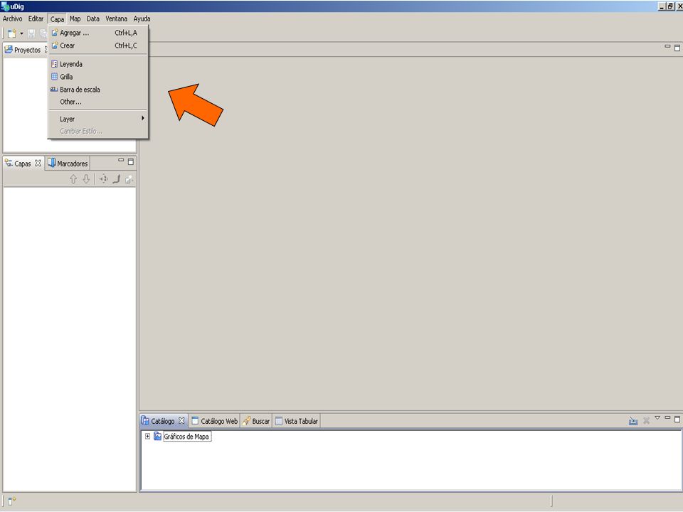
ADD LAYER Connection to the server via WFS

22
Insert the URL

23
Selecting and adding features for edition: cattle use

25
Editing geometries: add vertex

27
Once edition is finished changes are sent…

28
In that moment the user is required to insert a username and password

29
FEATURES – USER AUTHENTICATION
RESULTS FEATURES – USER AUTHENTICATION GeoServer uses its own authentication scheme File-based: user.properties and service.properties MIRAME IDE-Duero has a proprietary authentication scheme Web admin console to manage users and roles New roles defined in DB for geometry editing Agent that synchronizes MIRAME IDE-Duero users with geoserver authentication files Passwords stored using MD5 encription The file user.properties defines the users The file service.properties defines the role and service accessed: i.e wfs.Transaction= ROL_EDITOR_GEOSERVER Anytime the user is connected to GeoServer, the user. Properties file is automatically loaded.

30
FEATURES – CHANGE HISTORY
Changes are visible till validation only through the MIRAME-IDEDuero system. Authorized user can validate changes in the system. 30

31
CHANGE APPROVAL PROCESS
RESULTS CHANGE APPROVAL PROCESS EDITION FINISHED INTERMEDIATE TABLE NEW LAYER PUBLIC LAYER DISCARD QC/QA PROCESS NO OK OK User changes are not immediately applied to public layer Stored in an intermediate table Validator user needs to review and approve changes Then current version is moved to change history New version is written into public layer Versioning en Udig: default version (root version created by software editors) and WFS-T version created by wfs editors. Edits made to each version apply only to that version. Changes are not visible from the beginning. Once changes are sent the original layer is displayed and changes are saved in the historic of geometries. OLD LAYER HISTORIC LAYER 31
 and WFS-T version created by wfs editors. Edits made to each version apply only to that version. Changes are not visible from the beginning. Once changes are sent the original layer is displayed and changes are saved in the historic of geometries. OLD LAYER. HISTORIC LAYER. 31.")
32
CHANGE HISTORY Supports feature changes
RESULTS CHANGE HISTORY OLD LAYER HISTORIC LAYER Supports feature changes Points Lines Polygons Follows GIS Guide Recommendations Predecesor reference Limitations Doesn’t support complex operations (split, merge)
")
33
GIS GUIDE RECOMMENDATIONS
RESULTS GIS GUIDE RECOMMENDATIONS Appendix 9 – Management of Identifiers Cases specified New object (ID11); Object deleted (ID5); Split (ID4 into ID8 and ID9); Merge (ID3 and ID2 to ID7); Geometry change; possible cases: ID remains the same; small change (change of geometry only) (ID1); Large geometry change – new (ID6 to ID10).
; Object deleted (ID5); Split (ID4 into ID8 and ID9); Merge (ID3 and ID2 to ID7); Geometry change; possible cases: ID remains the same; small change (change of geometry only) (ID1); Large geometry change – new (ID6 to ID10).")
34
GIS GUIDE RECOMMENDATIONS
RESULTS GIS GUIDE RECOMMENDATIONS Appendix 9 – Management of Identifiers Cases covered by MIRAME IDE-Duero implementation: New object (ID11); Object deleted (ID5); Split (ID4 into ID8 and ID9); Merge (ID3 and ID2 to ID7); Geometry change; possible cases: ID remains the same; small change (change of geometry only) (ID1); Large geometry change – new (ID6 to ID10). ? ? The uncertainty is in what a SMALL/LARGE change means. En en caso de puntos sí está definido (más de 125 metros es large). In red are signed cases currently covered by MIRAME-IDEDuero implementation. Further developments will include the visualization of differences between the original version and modifications stored in the historic of geometries
; Object deleted (ID5); Split (ID4 into ID8 and ID9); Merge (ID3 and ID2 to ID7); Geometry change; possible cases: ID remains the same; small change (change of geometry only) (ID1); Large geometry change – new (ID6 to ID10). The uncertainty is in what a SMALL/LARGE change means. En en caso de puntos sí está definido (más de 125 metros es large). In red are signed cases currently covered by MIRAME-IDEDuero implementation. Further developments will include the visualization of differences between the original version and modifications stored in the historic of geometries.")
35
CONTENTS INTRODUCTION PROPOSED ARCHITECTURE. ALTERNATIVES
Server software Client software SOME RESULTS Editing User Authentication Change History CONCLUSIONS FURTHER DEVELOPMENTS 35

36
CONCLUSIONS Server Component Client Component Integration
GeoServer – good choice Client Component gvSIG currently not feasible (no WFS-T support) uDIG basic editing capabilities WFS-T supported Integration User Authentication - EASY Change History - CHALLENGING
 uDIG. basic editing capabilities. WFS-T supported. Integration. User Authentication - EASY. Change History - CHALLENGING.")
37
CONTENTS INTRODUCTION PROPOSED ARCHITECTURE. ALTERNATIVES
Server software Client software SOME RESULTS Editing User Authentication Change History CONCLUSIONS FURTHER DEVELOPMENTS 37

38
FURTHER DEVELOPMENTS Implement the rest of cases for management of identifiers Visualization of differences between original and edited version.

39
THANKS FOR YOUR ATTENTION
Good afternoon 39

Similar presentations


>")
 Desktop Web Feature Web Map Server.>")
![[Web] Geoprocessing A Practical Approach Castellón, June 2014 Javier Abadía Technical Marketing, ESRI España.](/13/3975463/big_thumb.jpg "[Web] Geoprocessing A Practical Approach Castellón, June 2014 Javier Abadía Technical Marketing, ESRI España.>")


>")


