Download presentation
Presentation is loading. Please wait.

1
Applications jlw, 17 February 2006

2
INDEXES OF TEMPERATURE IN NATURA 2000 SITES

3
NATURA2000 & Corilis URBAN 1 km² grid, span=5 km

4
INDEX OF URBAN TEMPERATURE in NATURA2000 sites 5 km neighbourhood & Corilis Urban

5
INDEX OF URBAN TEMPERATURE in NATURA2000 sites 5 km neighbourhood & Corilis Forests

6
INDEX OF URBAN TEMPERATURE in NATURA2000 sites 5 km neighbourhood & Corilis Pasture & Agriculture mosaics

7
INDEX OF INTENSIVE AGRICULTURE TEMPERATURE in NATURA2000 sites 5 km neighbourhood & Corilis Intensive Agriculture

8
SEBI 2010 QUICK START PACKAGE

9
1x1 & 10x10 km grids + land cover accounts/ sprawl+forest creation + SPA

10
1x1 & 10x10 km grids + SPA & NDA

11
1x1 & 10x10 km grids + green background map + SPA + urban sprawl & forest ceation

12
1x1 & 10x10 km grids at the European scale

13
…at the European scale + CLC

14
…at the European scale + GLC2000/CLC

15
…at the European scale + GLC2000

16
…at the European scale + Green background map from GLC2000

17
…at the European scale + NDA

18
CONNECTIVITY BACKGROUND MAP FOR CoE REPORT CORILIS AND LARCH

19
Pan-European version of the green background potentials

20
Integration of CDDA (8 Sept. 2005 update) / sites
 / sites")
21
Integration of CDDA (8 Sept. 2005 update) / sites + surface
 / sites + surface")
22
CORILIS & the LARCH model (Alterra) LARCH model (species oriented): Ecological profile :a range of species with similar sensitivity to landscape resistance (Opdam et al 2002) Key-population : persistant population due to its low extinction rate, compensated by an equally small recolosiation rate (1 im/generation) Key-patch : patch in a network that supports key population
 LARCH model (species oriented): Ecological profile :a range of species with similar sensitivity to landscape resistance (Opdam et al 2002) Key-population : persistant population due to its low extinction rate, compensated by an equally small recolosiation rate (1 im/generation) Key-patch : patch in a network that supports key population")
23
Ecoprofiles x x x x x x x x x x x x x x x x x x Pouwels et al, 2002 Dispersal range Key patch size

24
Synergies (translation of knowledge into data compatible terminology) LARCH Species group: CORILIS Dispersal distance: 25 km smoothing: 25 km Forest bound speciesClass 3.2 KP: 30 km 2 Thresholds (interactively): >70% for KP >60% for network Identification of corridors between networks (cost grid analysis)
 LARCH Species group: CORILIS Dispersal distance: 25 km smoothing: 25 km Forest bound speciesClass 3.2 KP: 30 km 2 Thresholds (interactively): >70% for KP >60% for network Identification of corridors between networks (cost grid analysis)")
25
CORILIS forest data (311+312+313) Restrict anaylsis to central and southern Europe
 Restrict anaylsis to central and southern Europe")
26
Reclassification according to key patches (KP) and networks (NW)
 and networks (NW)")
27
Cost paths and CORILIS forest grid, large mamals Test only ! ETCTE (UB-W, UAB) & Alterra
 & Alterra")
28
USE OF THE GREEN BACKGROUND MAP FOR TEN-TRANSPORT EXTENSION (support to DG ENV)
")
29
Potential impacts of TEN-T extension axis on green landscape

30
Modelling Green landscape with CLC (pink !) and comparison with IUNC ecological network
 and comparison with IUNC ecological network")
31
High nature value in the region

32
Via Baltica: Consumption Index of green background landscape

33
Potential impacts on Natura2000 sites (here, SPA)
")
34
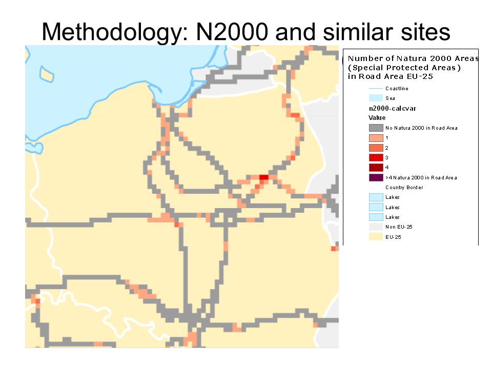
Methodology: N2000 and similar sites in transport axes 10x10 cells

36
Ecosystem accounts

37
Tentative framework of ecosystem accounts / tests wetlands, natural grassland

38
From land cover to ecosystem accounting Upscaling/downscaling Sampling/processing heterogeneous data System of stratifications (correlation of fuzzy sets, probability maps)
")
39
Data sources CLC1990+2000 Rivers CORILIS (stratifications) Texture (parcelisation, image segmentation) Small objects/ edges (CLC masks & pixels classification) Meteo NPP / fAPAR Soil biomass / C N deposition, eutrophication Species, habitats: from N2000, Atlases CLC 1975
 Texture (parcelisation, image segmentation) Small objects/ edges (CLC masks & pixels classification) Meteo NPP / fAPAR Soil biomass / C N deposition, eutrophication Species, habitats: from N2000, Atlases CLC 1975")
40
Integration of space monitoring into ecosystem accounting: CLC as a directory x structure/texture stratification x short time variability Vegetation productivity, seasonal change (MERIS/JRC-IES) Fires Droughts (SPOT4-Vegetation/ CNES – Vito) Forest structure (MODIS-Multi-angle/JRC-IES) Texture, parcelisation changes 1988 – 1998 (Landsat/JRC-IES)
 Fires Droughts (SPOT4-Vegetation/ CNES – Vito) Forest structure (MODIS-Multi-angle/JRC-IES) Texture, parcelisation changes 1988 – 1998 (Landsat/JRC-IES)")
41
CORINE LC (100m raster, SE 9ha):Forest mask from Landsat (25m, SE <1ha) CORINE: 40+ land cover classes and low spatial detail (available EU and 90-2000) Landsat: also 3 forest classes but much higher spatial detail JRC/ies, 2005, Estreguil C, Vogt P, Kozak J Classification of forests with CLC mask: small woods, perforations within forests, detailed edges. Can be repeated for other CLC classes

Similar presentations


 Markus Erhard.>")


