Download presentation
Presentation is loading. Please wait.

1
March17, 2014 Physical Geography of MENA Landform Map Warm-Up

2
Main Ideas Main Idea #1 –Landforms have a major impact on MOVEMENT in the region Peninsulas Mountains Strategic Waterways Main Idea #2 –The most valuable resources are oil and water. ½ of all Oil Reserves in the World Water is scarce some places plentiful in others

3
What is a region? A region is an area of the earth’s surface with similar characteristics

4
Characteristics of Southwest Asia and North Africa Physical –Arid (Dry) –Oil Cultural Culture Hearths World Religions Islam Judaism Christianity Conflict
 –Oil Cultural Culture Hearths World Religions Islam Judaism Christianity Conflict")
5
NAMING THE REGION Popular Labels –Dry World –Arab World –Islamic World –Middle East

6
Major physiographic provinces and physical features Southwest Asia and North Africa

7
MENA PHYSICAL FEATURES

8
Mountains – kept cultures isolated Elburz Mts., Iran Zagros Mts., Iran Pontic Mts., Turkey Taurus Mts., Turkey

9
Nile River Longest River in the World Built Aswan High Dam to control flooding Aswan created Lake Nasser Besides flood prevention, what else can a dam provide? –Hydroelectric Power

10
Mesopotamia Land between Tigris and Euphrates One of the earliest civilizations in the world The Fertile Crescent – Land surrounding Nile, Tigris and Euphrates Rivers.

11
Jordan River Natural Border Between Israel and Jordan Contains Dead Sea –2,300’ below sea level –High Salt Content (33%) Why would Israel & Jordan Fight Over Water Rights? –Limited resource in desert

12
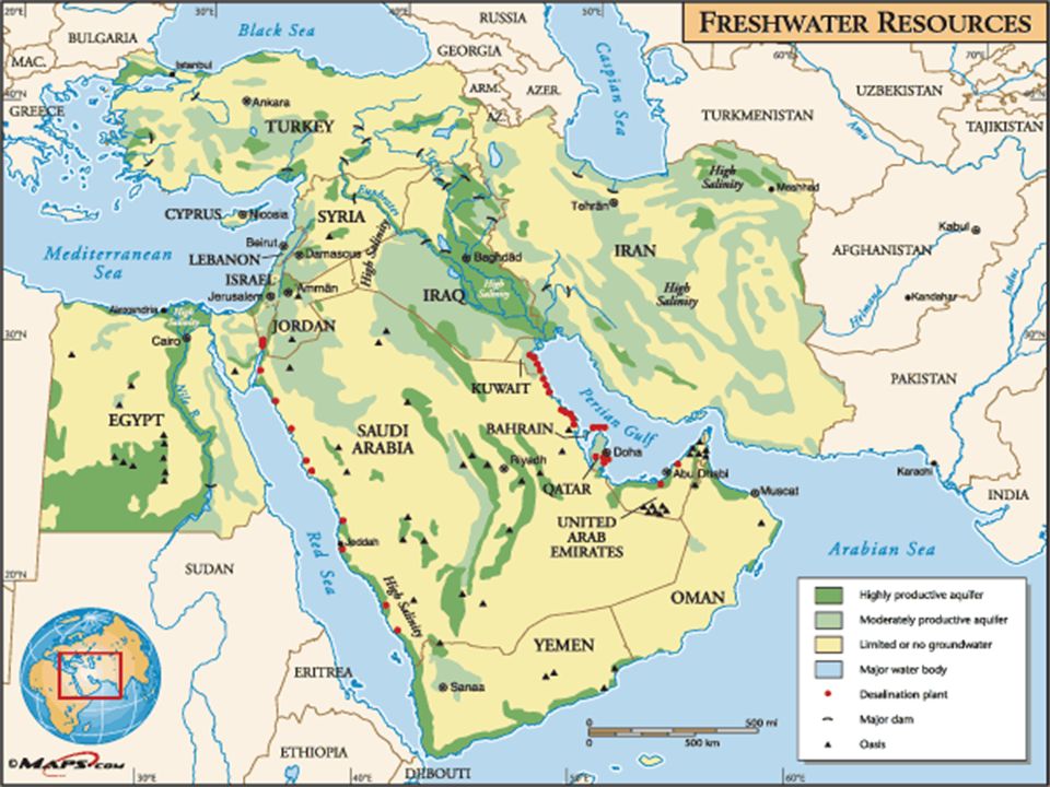
Other Water Sources Wadi – dry riverbed created by occasional floods Aquifer – stores of underground water Oasis – isolated area of vegetation in a desert around a water source Why are these sources important? –Provide water, transportation routes

13
Deserts Sahara –The size of the USA Rub al-Khali –Name means “Empty Quarter” –Vast oil Reserves

14
Straits Strait of Gibraltar –Separates Europe from Africa –8.9 Miles at closest point Strait of Hormuz –Only sea passage for Oil Tankers leaving Persian Gulf –34 Miles wide

15
CLIMATE

16
Where is the Middle East vs. the U. S. on Latitude Lines?

17
Physical Geography - Middle East: Climate Regions What climate type dominates the region? Desert = Arid

18
RESOURCES

20
Desalination Process that removes salt from Sea Water How might these plants change life for people in the Middle East? –Provide more drinking water, help support population growth

21
LAND USE What is the dominant form of agriculture in the Middle East?

22
What is Oil? Why is it Important? Produced from microscopic marine plants and animals, squeezed underground for millions of years. Oil is a “finite resource” Once it is used up, it is gone forever. Nobody is certain how much is left. Oil is used for many things: 1.Fuel, (gasoline, jet fuel, heating oil) 2.All plastic is made from petroleum 3.Asphalt used in road construction 4.Synthetic rubber in tires 5.Fertilizer, pesticides, and herbicides 6.Detergents, many drugs, and paints 7.Artificial fibers used in clothing (Nylon, Polyester)
 2.All plastic is made from petroleum 3.Asphalt used in road construction 4.Synthetic rubber in tires 5.Fertilizer, pesticides, and herbicides 6.Detergents, many drugs, and paints 7.Artificial fibers used in clothing (Nylon, Polyester).")
23
Where is the Oil?

24
Oil Producing Nations

25
Where is the Persian Gulf?

26
Why is the Persian Gulf important? The Persian Gulf is a vital part of the world oil supply. It is in a very dangerous part of the world It can easily be closed off by hostile countries.

27
Who Controls the World Oil Supply? OPEC - “Organization of the Petroleum Exporting Countries” Controls the price, production and distribution of oil. 66% of world reserves of oil, 40% of world oil production

28
Daily production

29
What is the future of oil? Prices will increase drastically! Europe 5 - 7 dollars a gallon U.S. $3 - $4 - $5?

30
What are our alternative energy sources? Solar Hydrogen Wind Nuclear Vegetable oil Grain alcohol – Gasohol/Ethanol Hydroelectric Ocean Currents Geo-Thermal

31
Review Describe how Landforms can impact MOVEMENT in this Region? Why must the USA be so involved in the Middle East?

Similar presentations


.>")


