Download presentation
Presentation is loading. Please wait.

1
CHARACTERIZE AND ASSESS WILDLIFE-HABITAT TYPES AND STRUCTURAL CONDITIONS FOR SUB-BASINS WITHIN THE BLUE MOUNTAIN PROVINCE Project: 27003

3
Purpose Develop a Coordinated and Consistent Set of Landscape Information Across Subbasins within the Mountain Snake Need Subbasin Planning: calls for detailed wildlife- habitat mapping to establish new habitat baseline conditions that are critical to evaluating the effectiveness of projects in improving habitat, watershed health….and to develop watershed assessments…to facilitate integrated resources management and planning efforts.. [Snake Hells Canyon Subbasin Summary, p.147].

4
specific local resource mangers goals and objectives support a need for mapping, for example Finer Resolution Mapping is supported or will meet over 20 current local Resource Managers Fish and Wildlife Goals, Objectives, and/or Strategies: Several examples are in the Snake Hells Canyon Subbasin Summary: Nez Perce Tribal Fisheries/Conservation Enforcement Goals (p.120); IDFGs Goal #1, Objective 1, Strategy 1.1.1. and 1.1.3 (p.121); Idaho Conservation Data Center Objective 2 (p. 126); and ODFWs Wildlife Diversity Plan, Objective 1, Strategy 1.2 (p.132).
; Idaho Conservation Data Center Objective 2 (p. 126); and ODFWs Wildlife Diversity Plan, Objective 1, Strategy 1.2 (p.132)..")
5
Develop a Product that will Assist in Evaluating and Assessing Future Fish and Wildlife Needs Evaluating Alternative Management Strategies Integrated Assessments of Fish and Wildlife and Ecological Functions Establish a Benchmark or Desired Condition

7
Consistently Map Wildlife Habitat Types Across the Province

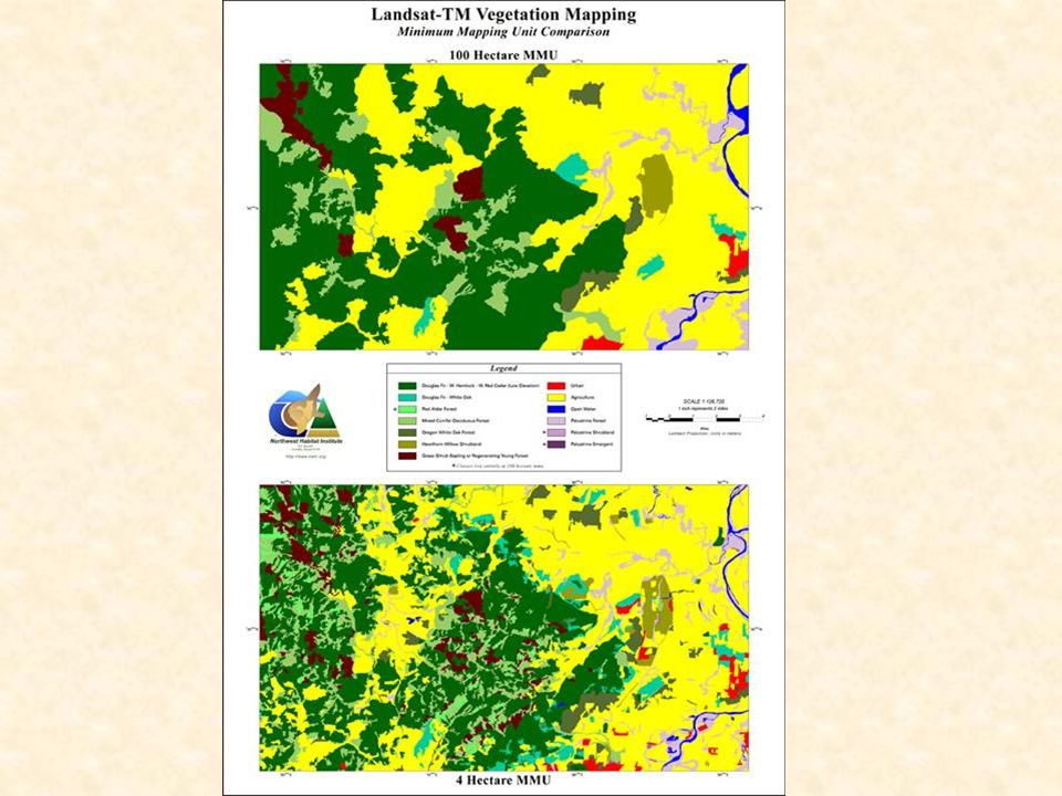
8
Consistently Map Structural Conditions Across the Province

13
Conclusion Mapping is consistent with NWPPCs Multi-Species Framework Mapping is consistent with NWPPCs Multi-Species Framework Mapping is integrated with a regional wildlife-habitat relationships data set Mapping is integrated with a regional wildlife-habitat relationships data set Mapping will be consistent with and within other subbasins Mapping will be consistent with and within other subbasins Finer resolution maps would directly Finer resolution maps would directly support local Fish and Wildlife Goals, Objectives, and Needs as outlined in Sub-basin Summaries

Similar presentations


 Sponsored by: The Colville Confederated Tribes Presented by: Bob Anderson Golder.>")


 and StreamNet NW Power & Conservation Council, Sept. 20, 2006.>")


