Download presentation
Presentation is loading. Please wait.

1
Chapter 6 Water Oceans and Freshwater

2
Oceans 71 % of earths surface covered with water
97 % of the water is in oceans In fact there is water around all the land

3
Three major oceans Atlantic, Pacific, Indian

4
Ocean Smaller, bodies of water almost surrounded by land are called seas. Mediterranean Sea, Black Sea, and Arctic Ocean are considered part of the Atlantic Ocean

5
Black Sea Mediterranean Sea

6
Oceans Pacific is larger than the Atlantic and Indian combined
Atlantic is second largest Pacific is deepest ocean Indian is second deepest Oceans have salt water

7
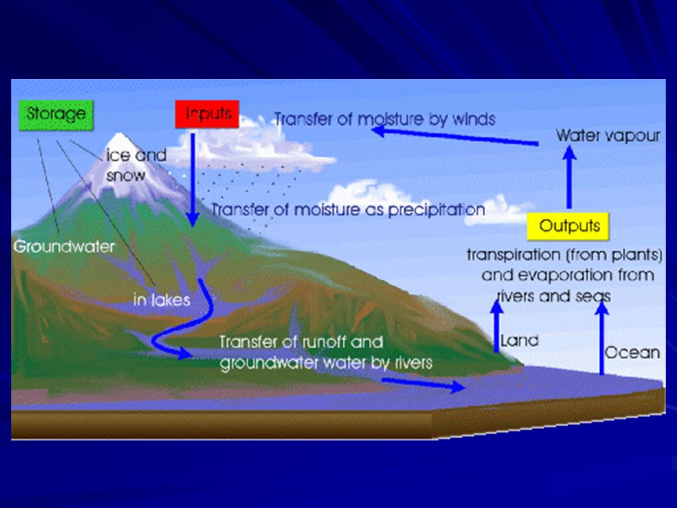
Water Cycle The circulation of water from oceans and lakes to the air and back. Sun heats water Water evaporates from ocean Leaves dissolved salt behind Water vapor is fresh water Clouds move the water vapor

8
Water Cycle Precipitation is falling fresh water
Rain snow, sleet and hail Some water flows back to ocean through rivers and streams Some seeps into ground to become groundwater

11
Ocean Water A mixture of water and dissolved gases and solids
Water is H2O 96% of ocean water 4% dissolved stuff Most elements have been found in ocean water

12
Ocean Water Sodium chloride most abundant Common table salt
Salinity – the number of grams of salt dissolved in 1 kilogram of water. Units are parts per thousand (ppt) If you evaporated 1 kilogram of water with a salinity of 35 ppt You would have 35 grams of salts
 If you evaporated 1 kilogram of water with a salinity of 35 ppt. You would have 35 grams of salts.")
13
Ocean Water Salinity of ocean water varies from place to place
Between 33 and 37 ppt

14
Ocean Water Sodium chloride 27.2 ppt Magnesium chloride 3.8 ppt
Magnesium sulfate 1.7 ppt Calcium sulfate 1.3 ppt Potassium sulfate 0.9 ppt Calcium carbonate 0.1 ppt Magnesium bromide 0.1 ppt

15
Sources Dissolved materials come from several sources
Volcanoes add gases, especially chlorine Erosion adds dissolved salts Rain erodes minerals Rivers carry them into ocean Source of potassium, sodium and magnesium

16
Sources Waves dissolve the minerals in the rocks along the shore.

17
Salinity varies It is lower where rivers flow into oceans
Large rivers like the Mississippi and the Amazon have the biggest effect Lots of freshwater dilutes the salt water. In warm water lots of evaporation makes the water have higher salinity In polar regions water freezes- only fresh water leaves the water with higher salinity

18
Dissolved Gases Most abundant gases are nitrogen, oxygen, and carbon dioxide Plants use carbon dioxide to make food And release oxygen Fish breathe the dissolved oxygen Varies by depth Alot at the surface Mixes with the waves Sunlight allows plants to exist

19
Dissolved Gases Varies with temperature of water
Warm water holds less gases than cold water Cold water is more dense- sinks In polar region oxygen rich water is carried to depths Allows fish to live in deep water

20
Ocean Temperature Sun supplies the heat
Water temperature is highest at surface Waves mixes surface water transfer heat downward Region where heat is mixed is called the surface zone In surface zone temperature is fairly constant Surface zone varies in depth

21
Ocean Temperature Surface zone varies by location Caribbean thick
Off the coast of Maine thin Varies with seasons Thermocline- region below the surface zone Water temperature drops with depth Cold deep water doesn’t mix with warm surface water

22
Ocean Temperature Deep zone- Extremely cold water from bottom of thermocline down Three zones vary in thickness In Arctic and Antarctic water is so cold there is no surface zone

23
The Ocean Floor Topography- the description of the shape ocean floor and its features Ocean floor is different from the continents. It has higher mountains Deeper canyons Larger, flatter plains Different type of rocks More volcanoes

24
Continents Edge Called the continental margin Three parts
Continental shelf Continental slope Continental rise

25
Continental Shelf More like land than ocean floor
Slopes gently from the shoreline Sediments from land are deposited Varies in width Atlantic 200 km Siberia 1200 km

26
Continental Shelf Many minerals and deposits of gas and oil
Claimed by countries as part of their boundaries

27
Continental Slope Floor goes down rapidly- steep slope
Boundary between continent crust and ocean crust

28
Continental Rise Slopes more gently
Made of sediments that come off the shelf Turbidity flows carry sediments down. Like underwater avalanches of sediment and water

29
Submarine Canyons V shaped valleys cut through shelf and slope
Caused by turbidity flows Bring deep water close to shore Monterrey Bay Good fishing

30
The Ocean Floor

31
The Ocean Floor Large flat areas are called abyssal plains
Biggest in Atlantic and Indian oceans Because of sediments from large rivers like The Mississippi and Amazon and the Ganges and Indus Rivers Trenches near the edge of continent trap Pacific sediments Made up of mud silt and clay

32
Mountains Underwater mountains are called seamounts They are volcanoes
Some rise above to form islands Like Hawaiian islands Large flat-topped mountains underwater called guyots Were worn away by waves. Then the ocean level rose

33
Trenches Deep narrow crevices in the ocean floor
Near the edge of continents Deepest is Marianas Trench m deep

34
Midocean Ridge Large underwater ocean ranges
Make one continuous chain around the world Formed when molten liquid comes up and forms new crust Consists of a valley between two parallel mountain ranges Valley is called a rift valley

36
Reefs Coral reefs are limestone made by organisms in shallow warm water Warmer than 18°C Shallower than 55 m Three types of reefs Fringing reefs around islands but touching Barrier reefs separated from shore by a shallow lagoon Atoll Reef surrounding a shallow lagoon no island

38
Coral Reefs Charles Darwin was the first to explain how one changed into another. Fringing reef forms in shallow water around volcanic island Water level rises slowly so corals build up, bu valocano starts to sink, making a barrier reef When volcano is completely gone- atoll

39
Ocean Life Zones Ocean life affected by Amount of sunlight Temperature
Pressure of water Three major groups of life Plankton- Float near the surface Many types of alga Source of food for many life forms.

40
Ocean Life Zones Neckton- ocean life that swims
Fish , whales , squid, octopus etc. Can be predators And avoid being prey Benthos- live on the ocean floor Plants where there is sunlight Animals like crab, oyster, star fish

41
Ocean Life Zones Three major environments
Intertidal zone- the region below high and low tide Most challenging for life Sometimes underwater Sometimes dry land Waves breaking on them Attach themselves to rocks to avoid being washed to sea

42
Ocean Life Zones Neritic zone- From low tide to the edge of the continental shelf. About 200 m deep Low water pressure, fairly constant temperature The most different plants and animals Great fishing areas Ends when sulight stops penetrating

43
Ocean Life Zones Two open ocean zones
Bathyal zone- Begins at continental slope and goes down 2000 m Little or no sunlight Many neckton Abyssal zone Little food for animals Life forms are small and strange looking Some produce their own light

44
Mapping the Ocean Floor
The deep ocean is difficult to measure High pressure crushes ships Earliest method is sounding Dropping lines until they hit the bottom Inaccurate and slow Nets to bring ocean water and life up

45
Modern Techniques Instruments like underwater cameras
Underwater robots Bathospheres and Bathyscaphs Indirect methods like sonar Send down sound waves They hit bottom and bounce up Detect signal Use speed of sound to calculate distance

49
Freshwater Only 3% of all the water
Of that 85% is ice in glaciers and icecaps That water is recycled in the water cycle Water evaporates from ocean Also evaporates from trees And from lakes Leaves the salt behind

50
Water cycle Next water condenses Changes back to liquid
Water must be cooled As it rises Forms clouds

51
Water cycle Next there is precipitation
There are so many water drops it falls out of clouds Rain snow sleet and hail When it hits the ground Some evaporates Some flows back to ocean Some absorbed into ground to become groundwater- which flows back to ocean

52
Water Cycle

53
Frozen Water Glaciers form when more snow falls in winter than melts in the summer. Must be cold Over the years snow piles up Pressure turns it to ice As ice gets thick, it starts to flow Glaciers have 2% of the freshwater

54
Glaciers Those that form in mountains are called valley glaciers
Flow down the valleys Rocks in the glacier wear away the valley walls Make the valley U-shaped

55
Glaciers In polar regions ice builds up in thick sheets
Form continental glaciers Cover millions of square kilometers Move slowly in all directions Found in Greenland and Antarctica One time covered much of America Icebergs break off glaciers

57
Standing water Water caught in low places as it runs off
Ponds and lakes Depressions caused by former glaciers are common places for lakes Or where there are blockages Ponds tend to be smaller and shallower than lakes

58
Standing water Reservoirs are artificial lakes
Made by damming rivers and streams Water backs up Used for drinking water, irrigation, recreation, and electric power

59
Running water Precipitation that doesn’t soak in flows into rivers and streams is called surface runoff Some soils soak up more than others Have more pore space Empty space between particles Less runoff Plants roots absorb water

60
Running water More runoff when there has been recent rains
Watershed is the land area that drains into a river or stream Some are huge- like the Mississippi Are divided by mountain ranges and ridges

61
Watershed

63
Groundwater Water below the surface
More fresh water underground than on the surface Precipitation move down through spaces between the rocks and soil Spaces are called pores Permeable rock lets water through Sandstone- large pores

64
Groundwater Impermeable rock does not let water through
Clay small pores Water moves downward until it reaches an impermeable layer Water fills up the permeable layers above Where water fills is called the zone of saturation Where pores are filled mostly with air is called the zone of aeration

65
Water Table Boundary between the zones
Water table is shallow near the ocean In the mountains it can be deep Where it rains a lot, it is shallow Where it is dry, it is deep Shallower in wet season Deeper in dry season Can be lowered by overuse

66
Aquifer A layer of underground water flowing horizontally through permeable rock Trapped above impermeable rock Reached by digging wells Pollution travels through them easily

67
Artesian Well If aquifer trapped between two layers of impermeable rock, Pressure builds up and forms an artesian well Water flows out of the ground by itself without pumping

68
Artesian Well

69
Caverns Water can slowly dissolve underground rock to form open tunnels Especially common in limestone Acidic water eats through it easily.

Similar presentations


 Depth = (time x 1500 m/sec)/2 (round trip) At 25 degrees.>")


 (calendar site) (calendar site) (calendar site) Friday, 12/6 Activities/Assignments: 1.Scale yourself on #5, 11 12 2.Stamp.>")