Download presentation
Presentation is loading. Please wait.

1
Properties of Sea Water
August 27

2
Reminders Text copies – Kinkos?
New Student Orientation – 11:45 am Today – MSL Conference Room Send to Heather –

3
Figure 3.14 (Stewart): The sea-floor topography of the ocean with 3km resolution produced from satellite altimeter observations of the shape of the sea surface. From Smith and Sandwell.

4
Physical Properties of Sea Water
Polar Molecule Water = H2O Can dissolve more substances than any other fluid Polar molecule – can form chains (polymers) up to 8 molecules long - leads to very high specific heat – large heat capacity Molecular chains lead to high surface tension, high viscosity Surface Tension -> Capillary Waves -> Air-Sea momentum transfer -> Gravity Waves and Ocean Circulation O-2
 up to. 8 molecules long. - leads to very high specific heat – large heat capacity. Molecular chains lead to high surface tension, high. viscosity. Surface Tension -> Capillary Waves -> Air-Sea momentum transfer -> Gravity Waves and Ocean Circulation. O-2.")
5
Physical Properties of Sea Water
Density (ρ) – kg/m3 – determined by temp. and salinity (conductivity) Pressure (p) Viscosity (ν) – causes resistance Surface Tension Thermal Conductivity Thermal Expansion Freezing Point Boiling Point Latent Heat Compressibility Heat Capacity All Conservative - All scalar quantities - no direction involved
 – kg/m3 – determined by temp. and salinity (conductivity) Pressure (p) Viscosity (ν) – causes resistance. Surface Tension. Thermal Conductivity. Thermal Expansion. Freezing Point. Boiling Point. Latent Heat. Compressibility. Heat Capacity. All Conservative - All scalar quantities - no direction involved.")
6
Other Properties Dissolved Oxygen Phosphate Nitrate Silicate
Optical Char. *Not Conservative* - depend on biology and geochemistry

7
Temperature and Salinity
Two most important properties of sea water – control density Density increases with depth, otherwise, would be unstable If surface waters cool, become heavier and sink - deep water is formed in the polar regions this way If excess evaporation over precipitation, get dense saline water at the surface, causes overturning - overturning occurs at low latitudes and in the Mediterranean Seas

8
Salinity Defined as a ratio of conductivities between sea water sample and standard sample No units – psu is not a unit – will get nasty letter from Milero Salinity is composed mostly of Cl- (chloride) ions (~19 ‰) and Na+ (sodium) ions (~10.6 ‰) but many other components Salts come from weathering of rocks on land and from hydrothermal vents Ratio of components is constant
 ions (~19 ‰) and Na+ (sodium) ions (~10.6 ‰) but many other components. Salts come from weathering of rocks on land and from hydrothermal vents. Ratio of components is constant.")
9
Salinity changes Due to: - Evaporation vs. Precipitation
- Runoff from land - Mixing of water masses - Freezing and melting of sea ice Highest salinities are found in surface layers at mid latitudes due to evaporation S = 35.0 to 36.5 above permanent thermocline Below 1000m, S=

12
Figure 6.3A: Sea-surface temperature anomaly for January 2005 relative to mean temperature shown in Figure 6.2 using data published by Reynolds and Smith (1995) in the Climate Diagnostics Bulletin for February 1995.
 in the Climate Diagnostics Bulletin for February 1995.")
13
Figure 6.3B: Annual range of sea-surface temperature in °C calculated from the Reynolds and Smith (1995) mean sea-surface temperature data set. Contour interval is 1°C with heavy contours at 4°C and 8°C. Shaded areas exceed 8°C.

15
Figure 6.5 Zonal average of sea-surface salinity calculated for all oceans from Levitus (1982) and the difference between evaporation and precipitation (E - P) calculated from data shown in Figure 5.14.
 and the difference between evaporation and precipitation (E - P) calculated from data shown in Figure 5.14.")
16
Figure 6.6 Water transported by the atmosphere into and out of the Atlantic. Basins draining into the Atlantic are black, deserts are white, and other drainage basins are shaded. Arrows give direction of water transport by the atmosphere, and values are in Sverdrups (1Sv=106 m3). Bold numbers give the net transport for the Atlantic. Overall, the Atlantic loses 0.32Sv, an amount approximately equal to the flow in the Amazon River. From Broecker (1997).
. Bold numbers give the net transport for the Atlantic. Overall, the Atlantic loses 0.32Sv, an amount approximately equal to the flow in the Amazon River. From Broecker (1997)..")
17
Density Determined by temperature, salinity, and pressure
Temperature (T) – ranges from ~-3°C to 34°C - mean temperature of the ocean's waters is: T = 3.5°C - easiest to measure - temperature differences are expressed in Kelvin (K) to avoid confusion with actual temperature K = °C Salinity (S) – ranges from 0 to 36.5 ‰ - mean salinity is S = 34.7 - T and S often used as a tracer of water masses The distribution about the mean is small: 50% of the water is in the range: 1.3°C <T< 3.8°C 34.6 < S < 34.8
 – ranges from ~-3°C to 34°C. - mean temperature of the ocean s waters is: T = 3.5°C. - easiest to measure. - temperature differences are expressed in Kelvin (K) to avoid confusion with actual temperature. K = °C Salinity (S) – ranges from 0 to 36.5 ‰ - mean salinity is S = T and S often used as a tracer of water masses. The distribution about the mean is small: 50% of the water is in the range: 1.3°C <T< 3.8°C 34.6 < S <")
18
Density Surface waters have high T and higher S – How can this be stable? - T effects out weigh S effects, so warmer, saltier water is still lighter than cooler, fresher water. r = r(S,T,P)≈1000 kg/m3 to 1030 kg/m3 See
≈1000 kg/m3 to 1030 kg/m3. See")
19
The Oceanic Mixed Layer and Thermocline
Wind blowing on the ocean stirs the upper layers leading to a thin mixed layer at the sea surface having constant temperature and salinity from the surface down to a depth where the values differ from those at the surface – typically °C colder than at the surface The depth and temperature of the mixed layer varies from day to day and from season to season in response to two processes: Heat fluxes through the surface heat and cool the surface waters. Changes in temperature change the density contrast between the mixed layer and deeper waters. The greater the contrast, the more work is needed to mix the layer downward and visa versa. Turbulence in the mixed layer mixes heat downward. The turbulence depends on the wind speed and on the intensity of breaking waves. Turbulence mixes water in the layer, and it mixes the water in the layer with water in the thermocline.

20
Figure 6.7 (Stewart): Growth and decay of the mixed layer and seasonal thermocline from November 1989 to September 1990 at the Bermuda Atlantic Time-series Station (BATS) at 31.8°N 64.1°W. Data were collected by the Bermuda Biological Station for Research, Inc. Note that pressure in decibars is nearly the same as depth in meters (see §6.8 for a definition of decibars).
..")
21
Figure 6.8 Typical temperature and salinity profiles in the open ocean. AAC: At 62.0°S, 170.0°E in the Antarctic Circumpolar Current on 16 January 1969 as measured by the R/V Hakuho Maru. Warm Pool: At 9.5°N, 176.3°E in the tropical west Pacific warm pool on 12 March 1989 as measured by Bryden and Hall on the R/V Moana Wave. BATS: At 31.8°N, 64.1°W near Bermuda on 17 April and 10 September 1990 as measured by the Bermuda Biological Station for Research, Inc. Data are included with Java Ocean Atlas.

22
In-situ temperature: what you measure - decreases with depth
Potential temperature (θ): temperature water would have if raised “adiabatically” to the surface - adiabatic: no exchange of heat with surroundings
: temperature water would have if raised adiabatically to the surface. - adiabatic: no exchange of heat with surroundings.")
23
Define: σt=r(S,T,0) – 1000 - shorthand for density of seawater at atmospheric pressure At great depths, must account for compressibility of seawater by using Potential Temperature to compute Potential Density - σθ - the density a parcel of water would have if it were raised adiabatically to the surface without change in salinity σθ=r(S,θ,0) – 1000
 –")
24
Figure 6.9 (Stewart): Profiles of Left in situ and potential temperature and Right sigma-t and sigma-theta in the Kermadec Trench in the Pacific measured by the R/V Eltanin during the Scorpio Expedition on 13 July 1967 at °E and °S. Data from Warren (1973).
..")
25
Figure 6.10 (Stewart): Vertical sections of density in the western Atlantic. Note that the depth scale changes at 1000 m depth. Upper: σθ, showing an apparent density inversion below 3,000 m. Lower: σ4 showing continuous increase in density with depth. From Lynn and Reid (1968).
..")
26
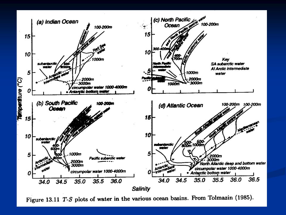
T-S diagrams: Figure from

27
Figure from http://www.cygres.com/OcnPageE/OcnPageFig4E.html

28
Figure from http://www. es. flinders. edu

29
Sketch of a TS-time diagram as it is developed from frequent observations. Measurements are made every other day. Each dot represents a measurement. Colors indicate different months. Changes from one measurement to the next indicate the variability on time scales of days. On a few occasions several measurements were made in a single day, and the resulting standard deviations in temperature and salinity are indicated by vertical and horizontal lines. They represent the daily variability. From

Similar presentations


 Only substance occurring.>")


; 4=(S,,4000).>")
 EarthsClimate_Web_Chapter.pdfEarthsClimate_Web_Chapter.pdf, p. 22-24.>")

 Surface temperature (°C) of the oceans in winter (January, February, March north of the equator; July, August, September south of the equator)>")


. Most elements.>")

