Download presentation
Presentation is loading. Please wait.

1
GOES Users’ Conference The Role of Geostationary Satellites in WMO’s Global Observing System Dr. Donald E. Hinsman Senior Scientific Officer WMO Satellite Activities

2
Purposes of WMO To facilitate world-wide cooperation in the establishment of networks of stations for the making of meteorological observations as well as hydrological and other geophysical observations related to meteorology, and to promote the establishment and maintenance of centres charged with provision of meteorological and related services; To promote the establishment and maintenance of systems for the rapid exchange of meteorological and related information; To promote standardization of meteorological and related observations and to ensure the uniform publication of observations and statistics; To further the application of meteorology to aviation, shipping, water problems, agriculture and other human activities; To promote activities in operational hydrology and to further close cooperation between Meteorological and Hydrological Services; To encourage research and training in meteorology and, as appropriate, in related fields, and to assist in coordinating international aspects of such research and training.

3
WMO Satellite Activities Main Long-term objectives ( i)Participate in the development of the Global Observing System (GOS) as a composite system, particularly for upper-air observing based on an optimal mix of observing components, including ground-based remote-sensing, mobile observing platforms, satellite and Global Position System-Meteorology (GPS-MET). GOS support to meeting GCOS requirements for climate monitoring and prediction will also be a priority goal; (ii)Assist Members in the transition of the low-resolution imagery satellite services from analogue to digital under complex operational conditions; (iii) Promote satellite-related high quality continuing education to keep the knowledge and skill of Members operational and scientific staff up-to-date with the latest technological innovations, and to provide the competence and skills needed in related fields, such as communication with users; (iv) Provide information, advice and guidance to Members on satellite-related technological developments as well as on changes in relevant existing meteorological and hydrological operation systems to enable them to develop plans for objective and wise investment actions.
Assist Members in the transition of the low-resolution imagery satellite services from analogue to digital under complex operational conditions; (iii) Promote satellite-related high quality continuing education to keep the knowledge and skill of Members operational and scientific staff up-to-date with the latest technological innovations, and to provide the competence and skills needed in related fields, such as communication with users; (iv) Provide information, advice and guidance to Members on satellite-related technological developments as well as on changes in relevant existing meteorological and hydrological operation systems to enable them to develop plans for objective and wise investment actions..")
4
Global Observing System Requirements Space-based component Geostationary satellites – at least five, appropriately spaced Missions: –Imaging –Data collection –Direct broadcast

5
Global Observing System Requirements (continued) Space - based component Polar-orbiting satellites – at least two, AM and PM Missions: Imaging Sounding Data collection Direct broadcast
 Space - based component Polar-orbiting satellites – at least two, AM and PM Missions: Imaging Sounding Data collection Direct broadcast")
6
Global Observing System Requirements (continued) Imagery mission (Hor res, obs cycle) Nowcasting requirement:1 – 5 km,.05 -.5 hours Global NWP1 – 50 km,.5 – 6 hours Sounding mission Nowcasting requirement:5 – 200 km,.25 – 1 hour Global NWP50 – 500 km, 1 – 12 hours
 Imagery mission (Hor res, obs cycle) Nowcasting requirement:1 – 5 km, hours Global NWP1 – 50 km,.5 – 6 hours Sounding mission Nowcasting requirement:5 – 200 km,.25 – 1 hour Global NWP50 – 500 km, 1 – 12 hours")
7
Global System of Geostationary Satellites

8
Global System of Polar Orbiting Satellites

9
WWW’s Global Observing System

10
Ground Segment of the Global Observing System - Four categories of satellite-data ground receiving stations Polar-orbiting satellites APT (Automatic Picture Transmission) HRPT (High Resolution Picture Transmission) Geostationary satellites WEFAX (Weather Facsimile) HR (High Resolution) - World Weather Watch implementation goals: “Each WMO Member should be equipped with at least one polar- orbiting satellite data receiver and one geostationary satellite data receiver”
 HRPT (High Resolution Picture Transmission) Geostationary satellites WEFAX (Weather Facsimile) HR (High Resolution) - World Weather Watch implementation goals: Each WMO Member should be equipped with at least one polar- orbiting satellite data receiver and one geostationary satellite data receiver")
11
SATELLITES AND THE WWW UN Resolution No. 1721 for “international co- operation in the peaceful uses of outer space” approved 20 December 1961 Advent of satellites offered substantial opportunities for improvements in meteorological services Called on WMO to lead a study and report on recommendations of the UN Resolution Report delivered in June 1962 “First report on the advancement of atmospheric sciences and their application in the light of developments in outer space” Birth of World Weather Watch On April 1, 1960 the first U.S. weather satellite was launched from Cape Canaveral, FL WMO’s World Weather Watch

12
Global System of Geostationary Satellites

13
Geostationary satellites areas Future plans Ground receiving stations LRIT and LRPT transition Frequency allocation protection WMO web page information International relations

14
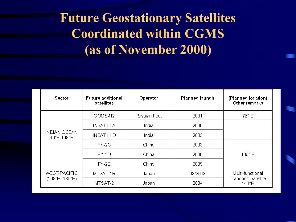
Future Geostationary Satellites Coordinated within CGMS (as of November 2000)
")
16
Growth of Member Satellite Receivers

17
Number of receivers in each WMO Region

18
Percent WMO Members meeting WWW Implementation Goals

19
Transition Schedule for Satellites in Geostationary Orbit for LRIT

20
Distribution of WEFAX Receivers

21
Distribution of High Resolution Geostationary Receivers

22
WMO Satellite Activities Web Site http://www.wmo.ch/hinsman/satsun.html Goals, objectives and publications Satellite operator status reports Global Observing System (GOS) status reports Other satellite related organizations Online database information APT/WEFAX to LRPT/LRIT transition Online satellite imagery sites Working documents for Upcoming Meetings Education and Training Materials
 status reports Other satellite related organizations Online database information APT/WEFAX to LRPT/LRIT transition Online satellite imagery sites Working documents for Upcoming Meetings Education and Training Materials")
23
Satellites and International Relations “Satellites are the best Ambassadors”

Similar presentations


 CBS EXPERT TEAM ON AIRCRAFT-BASED OBSERVING SYSTEMS 1st Session (Geneva, 10-13 September, 2013) Dr I.>")


 December 2013, GEONETCast Virtual.>")


>")

>")


>")
