Download presentation
Presentation is loading. Please wait.

1
Question and Answer Session Related to the Weather photo: D. Martin Douglas K. Miller Professor and Chair Atmospheric Sciences Department UNC Asheville

2
Outline Background – 14 questions submitted – Common themes Clarification of weather- and climate-related terms used in the mass media Unique regional weather & difficulties in forecasting them Clouds Global warming (climate change) Weather extremes
 Weather extremes")
3
Outline (cont.) Discussion – warm season – 2014 hurricane season – El Niño, La Niña Discussion – cool season – 2014, 2015 seasonal outlook – Polar vortex, Omega block – Inversions – 8 weather sources, 8 different forecasts
 Discussion – warm season – 2014 hurricane season – El Niño, La Niña Discussion – cool season – 2014, 2015 seasonal outlook – Polar vortex, Omega block – Inversions – 8 weather sources, 8 different forecasts")
4
Clouds Essentials of Meteorology, Ahrens, 6 th Edition

5
Clouds Essentials of Meteorology, Ahrens, 6 th Edition

6
Clouds Essentials of Meteorology, Ahrens, 6 th Edition

7
Clouds Essentials of Meteorology, Ahrens, 6 th Edition

8
Climate change (a.k.a, global warming) http://blogs.discovermagazine.com/imageo/files/2014/06/California-marine-stratus.jpeg
")
9
Climate change Essentials of Meteorology, Ahrens, 6 th Edition Ave. surface air temp. = 0 o FAve. surface air temp. = 59 o F

10
Climate change Essentials of Meteorology, Ahrens, 6 th Edition

11
Climate change How do we know it’s real? How do we know humans are likely accelerating the change? What can the U.S. do to change it or slow it down? Coming soon…relationship between climate change and the polar vortex

12
Essentials of Meteorology, Ahrens, 6 th Edition

13
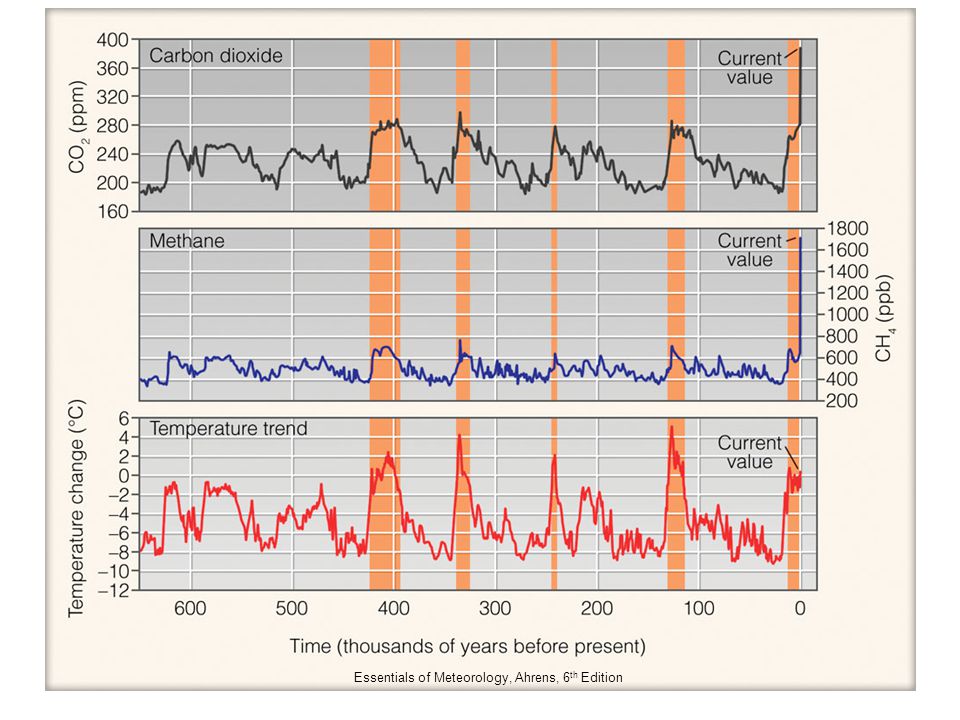
Climate change Essentials of Meteorology, Ahrens, 6 th Edition

14
Climate change

15
Essentials of Meteorology, Ahrens, 6 th Edition

17
Climate change

18
Weather extremes http://www.ncdc.noaa.gov/sotc/global/2014/9 NOAA’s “State of the Climate” publication – September 2014

19
Weather extremes http://www.ncdc.noaa.gov/sotc/global/2014/9 NOAA’s “State of the Climate” publication

20
Weather extremes http://www.climate.gov/news-features/event-tracker/2014-temperature-extremes-us-runs-hot-and-cold

21
Weather extremes http://www.climate.gov/news-features/event-tracker/us-temperature-extremes-and-polar-jet-stream Mid-Troposphere Difference from average pressure at 500 millibar (mb) pressure level January 14-21, 2014
 pressure level January 14-21, 2014")
22
Weather extremes http://droughtmonitor.unl.edu/

23
Weather extremes http://podaac.jpl.nasa.gov/OceanEvents/2014_09_04_CaliforniaCoast_warming

24
Warm season http://www.city-data.com/forum/attachments/western-north-carolina/101706d1348832930-western-nc-official-photo-thread-s75a0327-edit.jpg

25
2014 hurricane season http://www.washingtonpost.com/blogs/capital-weather-gang/wp/2014/12/01/unprecedented-lull-in-major-hurricane-landfalls-continues-as-atlantic-season-comes-to-a-close/ Atlantic Ocean basin… YearNamedHurricanesMajor Average12.16.42.7 2014862 http://en.wikipedia.org/wiki/2014_Atlantic_hurricane_season

26
2014 hurricane season http://www.washingtonpost.com/blogs/capital-weather-gang/wp/2014/12/01/unprecedented-lull-in-major-hurricane-landfalls-continues-as-atlantic-season-comes-to-a-close/ Atlantic Ocean basin… 2014; Total ACE was 62 % of a normal season

27
2014 hurricane season http://www.nhc.noaa.gov/data/tcr/index.php?season=2014&basin=epac E. Pacific Ocean basin… YearNamedHurricanesMajor Average15.47.63.2 201422169 http://en.wikipedia.org/wiki/2014_Pacific_hurricane_season

28
El Niño, La Niña Essentials of Meteorology, Ahrens, 6 th Edition

29
El Niño, La Niña Essentials of Meteorology, Ahrens, 6 th Edition

30
El Niño, La Niña Essentials of Meteorology, Ahrens, 6 th Edition

31
El Niño, La Niña Essentials of Meteorology, Ahrens, 6 th Edition

32
El Niño, La Niña Essentials of Meteorology, Ahrens, 6 th Edition

33
El Niño, La Niña Essentials of Meteorology, Ahrens, 6 th Edition

34
El Niño, La Niña Essentials of Meteorology, Ahrens, 6 th Edition

35
El Niño, La Niña Essentials of Meteorology, Ahrens, 6 th Edition Other oscillations have an impact on our winter… North Atlantic Oscillation

36
Cool season http://www.hcpress.com/img/viaduct-8.jpg

37
2014, 2015 seasonal outlook http://www.cpc.noaa.gov/products/analysis_monitoring/enso_advisory/ensodisc.html El Niño predictions for this winter…

38
2014, 2015 seasonal outlook http://www.cpc.ncep.noaa.gov/products/predictions/610day/ Climate Prediction Center’s 6 – 10 day outlook… Temperature

39
2014, 2015 seasonal outlook http://www.cpc.ncep.noaa.gov/products/predictions/610day/ Climate Prediction Center’s 6 – 10 day outlook… Precipitation

40
2014, 2015 seasonal outlook http://www.cpc.ncep.noaa.gov/products/precip/CWlink/daily_ao_index/ao_index_ensm.shtml NAO-related predictions for this month…

41
2014, 2015 seasonal outlook http://www.noaanews.noaa.gov/stories2014/20141016_winteroutlook.html NOAA…

42
2014, 2015 seasonal outlook http://www.noaanews.noaa.gov/stories2014/20141016_winteroutlook.html NOAA…

43
Polar vortex, Omega block http://glossary.ametsoc.org/wiki/Main_Page A planetary-scale mid- to high-latitude circumpolar cyclonic circulation, extending from the middle troposphere to the stratosphere. The Northern Hemisphere vortex often features two centers— one near Baffin Island and the other over northeast Siberia—with analogous circumpolar asymmetry atypical in the Southern Hemisphere. The westerly airflow is largely a manifestation of the thermal wind above the polar frontal zone of middle and subpolar latitudes. The vortex is strongest during the winter in the upper troposphere and stratosphere when the pole-to-equator temperature gradient is strongest. The stratosphere component of the circulation may be referred to separately as the “polar stratospheric vortex.” In summer, the strongest westerly circulation is largely confined to the troposphere, and the polar stratospheric vortex reverses in the upper stratosphere because of solar heating during the polar day.

44
Polar vortex, Omega block Essentials of Meteorology, Ahrens, 6 th Edition 2 – 5 December 2014

45
Polar vortex, Omega block Essentials of Meteorology, Ahrens, 6 th Edition 5 – 8 January 2014

46
Polar vortex, Omega block Essentials of Meteorology, Ahrens, 6 th Edition http://www.washingtonpost.com/blogs/wonkblog/wp/2014/11/20/theres-growing-evidence-that-global-warming-is-driving-crazy-winters/ Polar vortex – climate change connection?

47
Polar vortex, Omega block http://weather.uwyo.edu/upperair/uamap.html Remnants of Typhoon Nuri

48
Polar vortex, Omega block http://weather.uwyo.edu/upperair/uamap.html Ω Mid-Troposphere

49
Polar vortex, Omega block http://weather.uwyo.edu/upperair/uamap.html Mid-Troposphere

50
Inversions Essentials of Meteorology, Ahrens, 6 th Edition surface (radiational)
")
51
Inversions http://weather.uwyo.edu/upperair/sounding.html surface (radiational)
")
52
Inversions http://www.hpc.ncep.noaa.gov/archives/web_pages/sfc/sfc_archive.php

53
Inversions Purchase Knob, 7 November 2014, 11:30 am EST subsidence

54
8 weather sources, 8 different weather forecasts Miller, WaF, 2012

55
Why do we see so many different forecasts? – Everyone has access to the same information, but it seems every forecast is different, especially during the winter months. 8 weather sources, 8 different weather forecasts Answer (1) does source have local weather expertise? (2) which weather “animal” is driving the weather-of-the-day?
 does source have local weather expertise. (2) which weather animal is driving the weather-of-the-day .")
56
8 weather sources, 8 different weather forecasts Answer (1) does source have local weather expertise? (2) which weather “animal” is driving the weather-of-the-day? [i] planetary scale forecast consistency [ii] local scale forecast inconsistency
 which weather animal is driving the weather-of-the-day. [i] planetary scale forecast consistency [ii] local scale forecast inconsistency.")
57
8 weather sources, 8 different weather forecasts Answer (2) which weather “animal” is driving the weather-of-the-day? [i] planetary scale forecast consistency* [ii] local scale forecast inconsistency *there are exceptions to [i] (last week)
.")
58
8 weather sources, 8 different weather forecasts NWS snow forecast ending 7:00 pm EST 26 Nov 2014

59
http://www.hpc.ncep.noaa.gov/archives/web_pages/sfc/sfc_archive.php 8 weather sources, 8 different weather forecasts 7:00 pm EST 25 Nov – 7:00 am EST 27 Nov 2014

60
http://www.hpc.ncep.noaa.gov/archives/web_pages/sfc/sfc_archive.php 8 weather sources, 8 different weather forecasts 7:00 pm EST 25 Nov – 7:00 am EST 27 Nov 2014

61
http://www.hpc.ncep.noaa.gov/archives/web_pages/sfc/sfc_archive.php 8 weather sources, 8 different weather forecasts 7:00 pm EST 25 Nov – 7:00 am EST 27 Nov 2014

62
8 weather sources, 8 different weather forecasts Miller, WaF, 2012

63
7:00 pm EST 17 January 2013 8 weather sources, 8 different weather forecasts

64
1:00 pm EST 25 January 2013 8 weather sources, 8 different weather forecasts

65
The End photo: D. Martin

66
Helpful weather resources Lead time from the event 2 to 7 days 0 to 2 days Now Courtesy: D. Martin

67
Helpful weather resources 2 to 7 day event lead time – Climate Prediction Center 6-10 day outlook site http://www.cpc.ncep.noaa.gov/products/predictions/610day/ – NCEP computer weather model site http://mag.ncep.noaa.gov/ – Storm Prediction Center site http://www.spc.noaa.gov/ – National Hurricane Center site http://www.nhc.noaa.gov/ – Weather Prediction Center analysis site http://www.hpc.ncep.noaa.gov/ – National Weather Service forecast site http://www.weather.gov/

68
Helpful weather resources 0 to 2 day event lead time – NCEP computer weather model site http://mag.ncep.noaa.gov/ – Storm Prediction Center site http://www.spc.noaa.gov/ – National Hurricane Center site http://www.nhc.noaa.gov/

69
Helpful weather resources 0 to 2 day event lead time – Weather Prediction Center analysis site http://www.hpc.ncep.noaa.gov/ – National Weather Service forecast site http://www.weather.gov/ – Short Range Ensemble plume diagrams http://www.spc.noaa.gov/exper/sref/fplumes/index.php?YMD=2014 0127&RT=09&PRM=Total- SNO&SID=AVL&INC=ALL&NNC=&max=&min=&mZOOM=7&mLAT=35.58110839297158&mLON=-81.53716719970703&mTYP=roadmap http://www.spc.noaa.gov/exper/sref/fplumes/index.php?YMD=2014 0127&RT=09&PRM=Total- SNO&SID=AVL&INC=ALL&NNC=&max=&min=&mZOOM=7&mLAT=35.58110839297158&mLON=-81.53716719970703&mTYP=roadmap

70
Helpful weather resources Now – National Weather Service forecast site http://www.weather.gov/ – Regional WSR88D radar mosaic http://radar.weather.gov/Conus/full_loop.php – Regional observations http://weather.rap.ucar.edu/ – Local mesonet observations http://preview.weather.gov/edd/

Similar presentations

. The Atmosphere, 10ed. Upper Saddle.>")


 00px-The_Earth_seen_from_Apollo_17.jpg.>")
 Small geographic area Can change rapidly.>")

