Download presentation
Presentation is loading. Please wait.

1
Warm-up Canada’s leader of the government is called what?
Most of Canada's population is near the US border because why? Most of Canada's minerals are found where? Canada is a bilingual country what are there two official languages? In what province do some want to form there own country separate from Canada?

2
What physical features of Latin America do I need to know?
EQ What physical features of Latin America do I need to know?

3
9. Warm-up 1/14 10. Latin America Notes 11. Latin America Map
Table of Contents 9. Warm-up 1/ Latin America Notes 11. Latin America Map

4
Agenda Items Study Island Topics Latin America Geography
European 20th century

5
Brain Gym

6
Latin America Jingle Pacific Ocean Mexico Serra Madre Mountains The Gulf of Mexico is where the hurricanes flow Panama has the canal Columbia Venezuela Cuba Haiti share the Caribbean Sea The Atacama Desert Andes Mountains and Bolivia The Amazon River runs across northern Brazil And if you are on a boat and flowing down the river You will go the Atlantic where the Amazon ends

7
Perceptions of Latin America
When you think of Latin America, what perceptions come to mind? Using the categories below, record your perceptions about the region of Latin America. (You only need to write one or two words in each category.) Then, go around the room and ask your classmates their perceptions for each category.
 Then, go around the room and ask your classmates their perceptions for each category.")
8
Latin America is divided into three regions:
Mexico and Central America Caribbean South America

9
Mexico and Central America
2,500 miles (about as wide as the US) mountains dominate the region part of a huge system that extends from Canada, through the US, and all the way to the tip of South America central plateau in Mexico lies between Sierra Madre mountains and makes up more than half the country’s area Central America is an Isthmus. isthmus = a narrow strip of land that has water on both sides and joins two larger bodies of water many volcanoes in Central America, as a result, their soil is fertile and many people farm lands
 mountains dominate the region. part of a huge system that extends from Canada, through the US, and all the way to the tip of South America. central plateau in Mexico. lies between Sierra Madre mountains and makes up more than half the country’s area. Central America is an Isthmus. isthmus = a narrow strip of land that has water on both sides and joins two larger bodies of water. many volcanoes in Central America, as a result, their soil is fertile and many people farm lands.")
10
Mexican Plateau

11
Gulf of Mexico bordered by the US to the north, five Mexican states to the south, and Cuba to the east

12
Sierra Madre Mountains
mountain system in Mexico three major chains: the Sierra Madre Occidental in the west, the Sierra Madre Oriental in the east, and the Sierra Madre del Sur, which extends along the southern coast The Sierra Madre range contains some of the highest mountains and volcanoes in Mexico.

13
Sierra Madre Mountains

14
Mexico and Central America

15
Teach……. Ok……. 1’s explain the information you learned today to your elbow partner Switch 2’s explain the information you learned today to your elbow partner

16
Panama Canal canal across the isthmus of Panama in Central America
allows vessels to travel between the Pacific and Atlantic oceans handles a large volume of world shipping and enables vessels to avoid traveling around South America, reducing their voyages by thousands of miles and many days. consists of artificially created lakes, channels, and a series of locks, or water-filled chambers, that raise and lower ships through the mountainous terrain of central Panama

17
Panama Canal

18
Caribbean small islands are made of coral
skeletons of tiny sea animals, rock-like substance larger islands are tops of underwater mountains examples: Cuba, Jamaica

19
Caribbean Sea partially enclosed on the north and east by the islands of the West Indies, and bounded on the south by South America and Panama, and on the west by Central America a major trade route for Latin American countries a popular resort area—noted for its mild tropical climate and beautiful waters

20
Caribbean Sea

21
Teach……. Ok……. 1’s explain the information you learned today to your elbow partner Switch 2’s explain the information you learned today to your elbow partner

22
South America Andes Mountains—4,500 miles along west coast
They rise at some points to 20,000 feet—same height as twenty 100 story buildings stacked on top of each other 2nd largest mountains; Himalayas are the 1st highlands east of the Andes Amazon River Basin—contains the largest tropical rain forest (Amazon Rain Forest) in the world; covers 1/3 of the continent
 in the world; covers 1/3 of the continent.")
23
Andes

24
Amazon Rain Forest

25
South America Atacama Desert (Chile)—one of the driest places on earth; very little rainfall between the Pacific Ocean and the Andes Mountains

26
Atacama Desert

27
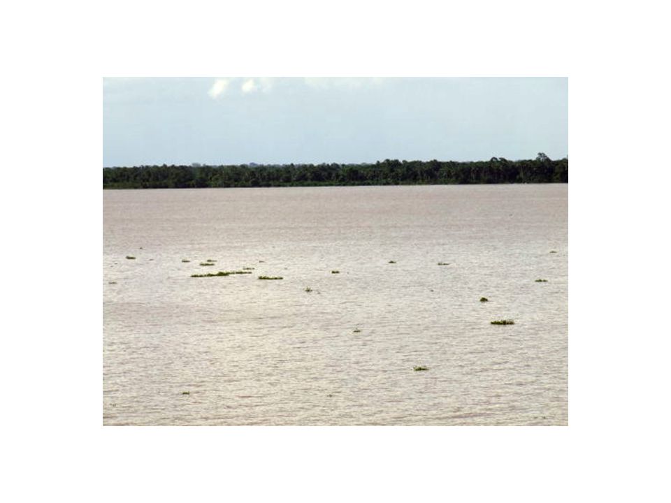
South America—Water rivers serve as natural highways where it’s hard to build roads provide food and hydroelectric power Amazon River—2nd largest river in the world (1st--Nile River) 4,000 miles from Peru across to Atlantic Ocean contains 20% of all fresh water in the world
 4,000 miles from Peru across to Atlantic Ocean. contains 20% of all fresh water in the world.")
28
Amazon River—view from space

30
Teach……. Ok……. 1’s explain the information you learned today to your elbow partner Switch 2’s explain the information you learned today to your elbow partner

31
Which body of water is nearest number 3?
Rio de Plato Atlantic Ocean Caribbean Sea Pacific Ocean

32
Which body of water is nearest number 9?
Pacific Ocean Atlantic Ocean Gulf of Mexico Artic Ocean

33
Which number is nearest the Sierra Madre Mountains?
9 5 10 8

34
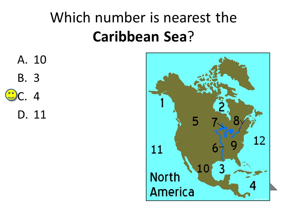
Which number is nearest the Caribbean Sea?
10 3 4 11
35
Which river is located nearest number 8?
Amazon Nile Mississippi Salado

36
Participant Leaders Points Participant

37
Target Time What is the 2nd longest river in the world?
What mountain range can be found in Mexico? What mountain range can be found on the western coast of South America? What desert is found between the Andes and the Pacific Ocean? The leader of Canada's government is called what?

38
Agenda Items Latin America Map Test on Friday Study Island Topics
Latin America Geography European 20th century

39
When you think of Latin America, what perceptions come to mind?
EQ When you think of Latin America, what perceptions come to mind? What are characteristics of the major physical features in Latin America?

40
Brain Gym

41
Latin America Gestures

42
Teach……. Ok……. 1’s explain the information you learned today to your elbow partner Switch 2’s explain the information you learned today to your elbow partner

43
Political and Physical Features of Latin America
_Part Two: Use a pen to label the following eight physical features on the map: Amazon River Caribbean Sea Gulf of Mexico Pacific Ocean Panama Canal Andes Mountains Sierra Madre Mountains Atacama Desert 1. Color the Pacific Ocean, Amazon River, and the Gulf of Mexico DARK BLUE. 2. Color the Caribbean Sea LIGHT BLUE (or TEAL). 3. Draw a RED box where the Panama Canal is located. 4. Draw triangle symbols around the Andes Mountains and color them GREEN. 5. Draw triangle symbols around the Sierra Madre Mountains and color them YELLOW. 6. Color the Atacama Desert BROWN. Political and Physical Features of Latin America Part One: Use a pen to label the following nine countries on the map: Chile Brazil Colombia Cuba Haiti Mexico Panama Venezuela Peru Next, use a marker to outline the political border of each country.
. 3. Draw a RED box where the Panama Canal is located. 4. Draw triangle symbols around the Andes Mountains and color them GREEN. 5. Draw triangle symbols around the Sierra Madre Mountains and color them YELLOW. 6. Color the Atacama Desert BROWN. Political and Physical. Features of Latin America. Part One: Use a pen to label the following nine countries on the map: Chile Brazil Colombia Cuba Haiti Mexico Panama Venezuela Peru Next, use a marker to outline the political border of each country.")
44
Which body of water is nearest number 3?
Rio de Plato Atlantic Ocean Caribbean Sea Pacific Ocean

45
Which body of water is nearest number 9?
Pacific Ocean Atlantic Ocean Gulf of Mexico Artic Ocean

46
Which number is nearest the Sierra Madre Mountains?
9 5 10 8

47
Which number is nearest the Caribbean Sea?
10 3 4 11

48
Which river is located nearest number 8?
Amazon Nile Mississippi Salado

49
Participant Leaders Points Participant

50
What number corresponds to Brazil?
9 8 5 7

51
What country corresponds to number 5?
Argentina Venezuela Columbia Cuba

52
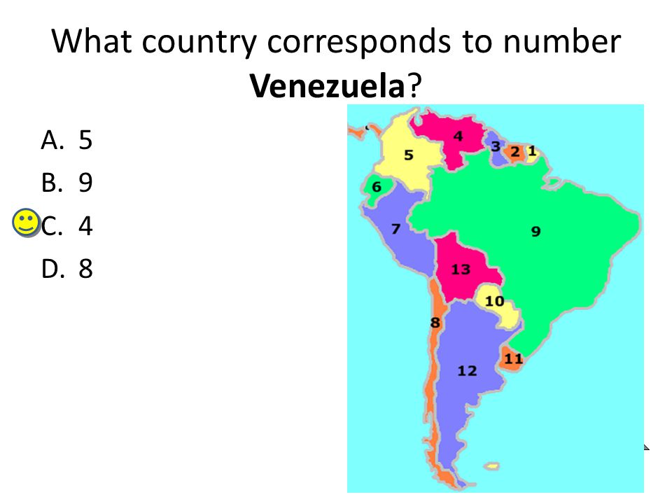
What country corresponds to number Venezuela?
5 9 4 8
53
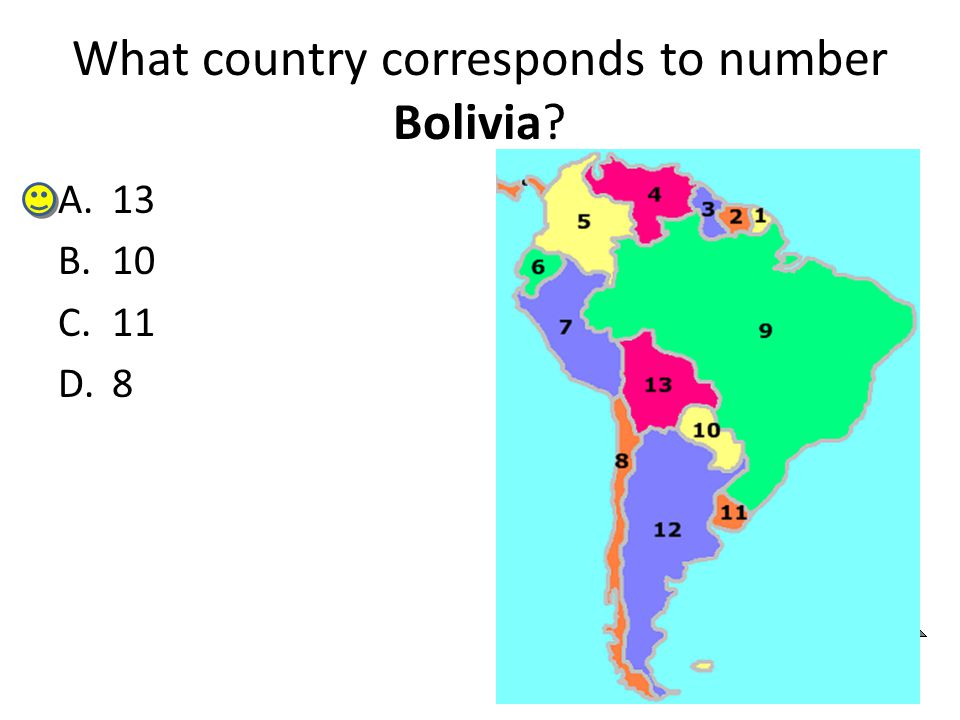
What country corresponds to number Bolivia?
13 10 11 8
54
Participant Leaders Points Participant

55
What country corresponds to number Mexico?
13 10 11 8

56
What country corresponds to number Cuba?
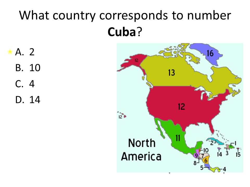
2 10 4 14
57
What country corresponds to number 4?
Hattie Mexico Cuba Panama

58
What country corresponds to number 3?
Hattie Mexico Cuba Panama

59
What percentage of your current points would you like to wager on the next question?
0% 25% 50% 75% 100%

60
What country corresponds to number 3?
Gulf of Mexico Caribbean Sea Serra Madre Atlantic Ocean

61
Create-A-Plate There is a new Latin American restaurant in our town! The restaurant owner is planning to serve yummy foods, like Caribbean Chimichangas and the Atacama Spicy Stew. Even though he has an awesome menu lined up, he has one small problem…he doesn’t have any plates on which to serve the food! The owner needs your help in designing plates that could be used in his restaurant. He wants you to create a plate that includes the important physical features of Latin America: Caribbean Sea, Gulf of Mexico, Panama Canal, Amazon River, Andes Mountains, Sierra Madre Mountains, & the Atacama Desert. Feel free to add any additional illustrations to your plate design—the more Latin American-inspired, the better! The plate should be colorful, informative, and creative.

Similar presentations