Download presentation
Presentation is loading. Please wait.

1
Concepts and Foundations of Remote Sensing

2
Remote Sensing Definition

3
Remote Sensing Definition
Science and art of obtaining information about an object, area, or phenomenon through the analysis of data acquired by a device that is not in contact with object, area, or phenomenon. It usually relies on measurement of electromagnetic energy reflected or emitted from the features of interest.

4
What is Remote Sensing? remote sensor or sensor (n) more definitions
instruments that acquire remotely sensed information more definitions unconventional definitions

5
What are Remote Sensing Images Used For?
studies of: the atmosphere the oceans land areas life on Earth

6
Remote Sensing Processes
Data acquisition - energy sources - energy through the atmosphere - interaction with surface features - retransmission - sensor systems - data - interpretation and analysis

7
Remote Sensing Processes
Data analysis: - data processing - compilation - application

8
Remote Sensing Processes

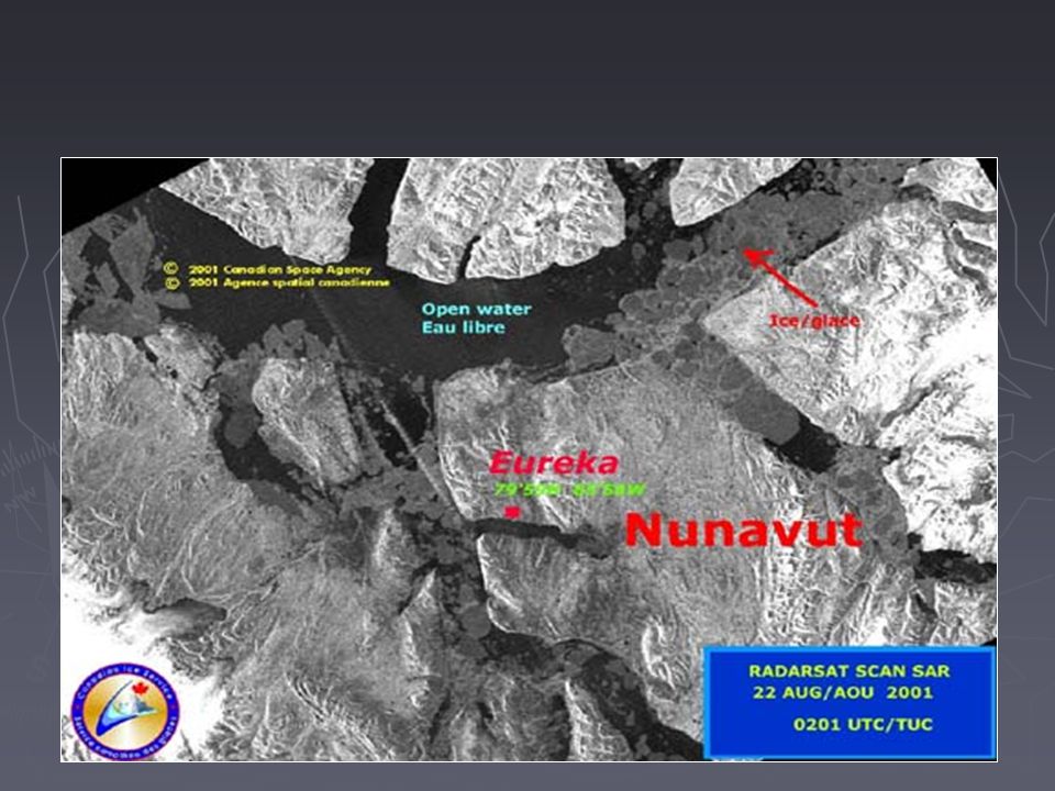
9
Causes of differences in scale of aircraft and satellite observations

10
MODIS (Terra) August 24, 2002 This pair of images from Saskatchewan Canada showcases in dramatic detail wildfire burn scars for the past two years. Details are msot visible in the false-color iamges in the pair. Against the vibrant green backdrop that represents vegetation-covered land surfaces, two kinds of burn scars are present. The light orange-yellow pattern shows what was burned last year. The color is lighter because much of the vegetation has returned over the course of the year. The more vegetation that returns, the fainter the burn scars will become, until they fade completely away. Meanwhile, the dark red patches are burn scars from the current fire season. They show up so well because vegetation in these areas has not had much chance to regenerate. Some of these scars are quite large, though they are not as extensive as those from last year. Also present in the image are bodies of water, shown in black, and some cloud cover, shown in white and light blue. The sheer number of black patches shows how wet a place Saskatchewan is. This image was acquired by the Terra MODIS instrument on August 24, 2002.

12
Regina Landsat 7 ETM+ 2000

22
Resembling a work of modern art, variegated green crop circles cover what was once shortgrass prairie in southwestern Kansas. The most common crops in this region—Finney County—are corn, wheat, and sorghum. Each of these crops was at a different point of development when the Advanced Spaceborne Thermal Emission and Reflection Radiometer (ASTER) captured this image on June 24, 2001, accounting for the varying shades of green and yellow. Healthy, growing crops are green. Corn would be growing into leafy stalks by late June. Sorghum, which resembles corn, grows more slowly and would be much smaller and therefore, possibly paler. Wheat is a brilliant gold as harvest occurs in June. Fields of brown have been recently harvested and plowed under or lie fallow for the year. Like crops throughout large sections of the U.S. Midwest, these crops are partly fed by water from the Ogallala Aquifer, a giant layer of underground water. One of the largest underground repositories in the world, the Ogallala Aquifer lies under about 450,000 square kilometers of the Great Plains—an area that includes parts of eight U.S. states. The water is between 30 and 100 meters below ground, and the amount of water in the aquifer varies greatly from region to region. Though the aquifer is a reliable source of water for irrigated cropland, there are some concerns that it could eventually run dry. Most of the water in the aquifer is “fossil water” from the last ice age. The rivers and streams that initially fed the aquifer have long since disappeared in the geologic development of the West after the last ice age. Water now takes a long time to trickle down through the soil to recharge the aquifer, though the rate varies from region to region. Like a bank account, if more water is taken from this underground bank than is deposited into it, it could run dry. For this reason, efforts are being made to conserve the water of the Ogallala Aquifer. One conservation measure is using water more wisely so less is drawn out of the aquifer. Farmers in this region have adopted a more efficient irrigation method, central pivot irrigation. Central pivot irrigation draws water out of a single well in the center of the field. Long pipes perched on wheels rotate around the pivot, showering the crops with water. Because the water falls directly on the crops instead of being shot into the air as occurs with traditional sprinklers, less water is lost to evaporation and more goes to nourishing the growing plants. Central pivot irrigation also creates perfectly circular fields, as seen in this image. The fields shown here are 800 and 1,600 meters (0.5 and 1 mile) in diameter. The large image is centered near 37.4 degrees north latitude, degrees west longitude, and covers an area of 37.2 x 38.8 km.
 in diameter. The large image is centered near 37.4 degrees north latitude, degrees west longitude, and covers an area of 37.2 x 38.8 km.")
25
Snow and ice serve to accent human activities in this photograph taken by the Space Shuttle mission STS-98 crewmembers on February 17, 2001 (STS B-84). The Souris River stretches across the photograph from left to right, with the upstream Rafferty Dam Reservoir frozen over on the far left. Two power plants, the Boundary Dam Power Station and the Shand Power Station, can be identified by the smoke plumes and shadows of those plumes. The river is frozen over upstream of the Boundary Dam Power Station, but thermal loading from the plants has warmed the water in the Boundary Dam Reservoir so that it remains nearly ice free. Downstream of the reservoirs, thermal loading is sufficient to maintain open flow in the Souris River. The Estevan Coalfield is a formation of about 1500 square km that accounts for most of Saskatchewan’s coal production. The coal is mined from a trench at the surface, processed, and then used to fire the two power plants. These plants provide almost half of Saskatchewan’s electricity. Areas of active surface mining and processing appear black in the photograph; roads used for transporting the coal are also dusted black. Around the areas of the mines, a rough texture reveals other spoil piles and areas where underground mining used to take place. The city of Estevan (population about 12,000) is the medium-gray gridded area in the upper left of the photo. Satellite: Space Shuttle Sensor: 35mm Camera Image Date:
 is the medium-gray gridded area in the upper left of the photo. Satellite: Space Shuttle. Sensor: 35mm Camera. Image Date:")
29
On May 3, 2003, a group of intense supercell thunderstorms spawned multiple tornados that swept across Oklahoma and nearby states. One of the tornados touched down in the town of Moore, just south of Oklahoma City. The path of the tornado is visible in this high-resolution satellite image, acquired by the IKONOS satellite on May 10, In the center of the tornado’s swath homes were totally destroyed. The satellite’s 1-meter maximum resolution reveals the extent of the destruction.

31
About 50 miles north of the Washington (U. S
About 50 miles north of the Washington (U.S.)-British Columbia (Canada) international line, a devastating wildfire has been burning in the Okanagan Mountain Park for several weeks. Tens of thousands of people have been on and off evacuation alert during that time, as the fire flares and subsides in response to varying terrain and weather conditions. As of September 5, 2003, nearly 3200 people in the southeastern part of the city of Kelowna were ordered from their homes as the 23,000-hectare (~57,000-acre) fire moved closer. At one point, nearly 30,000 people were forced out, about one-third of the city’s total population. This image from the Advanced Spaceborne Thermal Emission and Reflection (ASTER) radiometer on the Terra satellite was captured on September 2, 2003, and shows the widespread devastation left by the blaze. The deep pink area tucked into the bend in Okanagan Lake is the burned area. Smoke (light blue) and areas of active burning (bright pinkish-white) are visible at the northeast perimeter of the fire. North of the fire is the city of Kelowna. Vegetation is in various shades of green.
-British Columbia (Canada) international line, a devastating wildfire has been burning in the Okanagan Mountain Park for several weeks. Tens of thousands of people have been on and off evacuation alert during that time, as the fire flares and subsides in response to varying terrain and weather conditions. As of September 5, 2003, nearly 3200 people in the southeastern part of the city of Kelowna were ordered from their homes as the 23,000-hectare (~57,000-acre) fire moved closer. At one point, nearly 30,000 people were forced out, about one-third of the city’s total population. This image from the Advanced Spaceborne Thermal Emission and Reflection (ASTER) radiometer on the Terra satellite was captured on September 2, 2003, and shows the widespread devastation left by the blaze. The deep pink area tucked into the bend in Okanagan Lake is the burned area. Smoke (light blue) and areas of active burning (bright pinkish-white) are visible at the northeast perimeter of the fire. North of the fire is the city of Kelowna. Vegetation is in various shades of green.")
Similar presentations


 11. (Definition) (Object) (Phenomena)>")


