Download presentation
Presentation is loading. Please wait.

1
Kalkaska County of Michigan By James Stringer

3
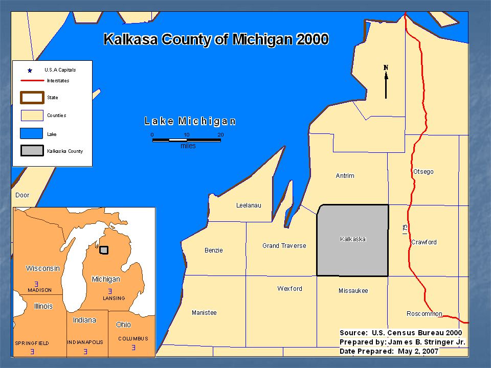
Reference Map This map illustrates where Kalkaska County is located in proximity of surrounding Michigan counties. The map also illustrates the surrounding states if Michigan. Displayed on the map is nearest body of water, location of U.S. interstate highways, and U.S Capitals of Michigan and surrounding states. This map illustrates where Kalkaska County is located in proximity of surrounding Michigan counties. The map also illustrates the surrounding states if Michigan. Displayed on the map is nearest body of water, location of U.S. interstate highways, and U.S Capitals of Michigan and surrounding states.

4
Used a natural break method Used a natural break method Projection: Latitude/Longitude (NAD 83) Projection: Latitude/Longitude (NAD 83) This thematic map illustrates the demographics of males concentrated in Kalkaska County. This thematic map illustrates the demographics of males concentrated in Kalkaska County. The data used in this map is from the U.S. Census Bureau 2000 data for persons per census block. The data used in this map is from the U.S. Census Bureau 2000 data for persons per census block. Kalkaska County’s population of males is concentrated in the Southwestern and Northwestern regions of the county. Kalkaska County’s population of males is concentrated in the Southwestern and Northwestern regions of the county.

5
This thematic map illustrates the distribution of households located in Kalkaska County. The data used in this map is from the U.S. Census Bureau 2000 data for persons per census block. Kalkaska County’s distribution of households is concentrated in the Southwestern and Northwestern regions of the county. Used a natural break method Used a natural break method Projection: Latitude/Longitude (NAD 83) Projection: Latitude/Longitude (NAD 83)
 Projection: Latitude/Longitude (NAD 83).")
6
Figure 1: This bar graph shows the amount of housing units by Census Block in 2000 that were in each county located in the northern part of Michigan’s peninsula that are of the surrounding counties of proximity to Kalkaska County. As illustrated Grand Traverse holds the largest amount of housing units. The county with the least amount of housing units is Crawford County. Source: U.S. Census Bureau 2000 Prepared by: James B. Stringer Jr. Date Prepared: May 2, 2007

7
Figure 2: This pie chart shows the amount of families by Census Block in 2000 that were in each county located in the northern part of Michigan’s peninsula that are of the surrounding counties of proximity to Kalkaska County. As illustrated Grand Traverse holds the largest amount of families. The smallest amount of families shown in the four county region is associated to Crawford County.

8
Thank You!!

Similar presentations