Download presentation
Presentation is loading. Please wait.

1
Remote Sensing 2 Course Code: Geog424 Dr. M. M. Yagoub E-mailE-mail: myagoub@uaeu.ac.aemyagoub@uaeu.ac.ae E-mail: myagoub@hotmail.com URL : http://faculty.uaeu.ac.ae/~myagoub URL : http://www.angelfire.com/mo/yagoub

2
Overview Course description Course outcomes Topics Assessment Software used for the course Textbook and References Examples remote sensing web sites Remote Sensing Organizations Remote sensing basic processes Advantages of remote sensing Remote sensing applications

3
Course description This course covers various advanced techniques of image processing and analysis of remotely sensed digital data. Topics include radiometric correction, geometric correction, atmospheric and ground effects, image enhancement, spectral analysis, color processing, image filtering, image classification, post-classification, change detection, and practical exercises based on satellite datasets.

4
Course outcomes Participants who successfully complete this course will be able to perform the followings: - Understand and apply image processing techniques for information extraction. - Implement and analyze image enhancement techniques. - Implement, evaluate, and analyze image classification methods. - Understand current representations and methods in image processing.

5
Topics Topics covered in the course include the followings: Introduction to digital image processing and visual interpretation Remote sensing data acquisition alternatives Image processing system considerations Image processing statistics and visualization Radiometric and geometric correction Image Enhancement Digital Image classification (Supervised, Unsupervised, Fuzzy) Digital change detection New trend in remote sensing (Digital cameras, Hyper-spectral scanners, high resolution satellite imagery-IKONOS)
 Digital change detection New trend in remote sensing (Digital cameras, Hyper-spectral scanners, high resolution satellite imagery-IKONOS)")
6
Assessment Final Exam 40% Mid Term Exam 25% Quiz 10% Course work 20% Computer presentation 5% Total 100%

7
Software used for the course Software used for the course: ERDAS Imagine and ArcGIS. ERDAS: ERDAS is a raster image processing software that can be used to display, enhance, geo-reference, classify, and produce a layout map of an images. ERDAS will be used as the main software for this course. ArcGIS: ArcGIS is a vector GIS software that can be used to geo-reference satellite image and produce a map from the image through on screen digitization.

8
Textbook and References Textbook Jensen, J. R., 1996. Introductory Digital Image Processing : A Remote Sensing Perspective, 2 nd ed. New Jersey: Prentice Hall. References Avery T. E. and Berlin G. L., 2004. Fundamentals of Remote Sensing and Air photo Interpretation. Prentice Hall: New Jersey. Campbell, J. B., 1996. Introduction to Remote Sensing. 2 nd ed., Taylor and Francis: London. Castleman, K. R. 1996. Digital Image Processing. Prentice-Hall: London. Lillesand, T. M. and R. W. Kiefer, 2000. Remote Sensing and Image Interpretation. 4 th ed., John Wiley and Sons, Inc.: New York.

9
Remote sensing web sites http:// www.esrin.esa.it - Eurpopean Space Agency http://geo.arc.nasa.gov - NASA program http://www.spot.com - French satellite SPOT http://www.nasda.go.jp/ - Japan space agency http://www.rka.ru./ - Russian Space Agency (RSA)http://www.rka.ru./ http://www.coresw.com - Russian imagery source http://www.space.gc.ca/ - Canadian Space Agency (CSA)http://www.space.gc.ca/ http://www.ccrs.nrcan.gc.ca/ccrs/ -Canada Center for Remote Sensing http://www.inpe.br/ - National Institute for Space Research (Brazil)http://www.inpe.br/ http://www.asprs.org - American Society of Photo. And RS. http://www.man.ac.uk - Manshester Univ. http://www.idrisi.clarku.edu - Idrisi site http://www.amazon.com - Bookstore http://www.brevard.cc.fl.us/BTR_Labs/bober/martin/rs/overview.htm Dr. Martin McClinton, (*.ppt) format (V. Good)
 format (V. Good).")
10
Remote Sensing Organizations ISPRS- International Society for Photogrammetry and Remote Sensing IGARSS- International Geosciences And Remote Sensing Symposium NASA - National Aeronautic and Space Administration (USA) ESA- European Space Agency (Europe) NASDA- National Space Development Agency (Japan) CNES- Centre National d'Etudes Spatiales (France ) DARA - German Space Agency CSA - Canadian Space Agency NRSA - National Remote Sensing Agency of India
 ESA- European Space Agency (Europe) NASDA- National Space Development Agency (Japan) CNES- Centre National d Etudes Spatiales (France ) DARA - German Space Agency CSA - Canadian Space Agency NRSA - National Remote Sensing Agency of India")
11
Remote sensing basic processes Statement of the problem (appropriate logic: inductive, deductive, technological, formulate hypothesis). Data collection (In situ, field, lab, passive and active remote sensing, energy propagation, platforms, conversion of energy pattern to images). Data Analysis (Visual image interpretation, digital image processing, hypothesis testing –accept or reject, quantitative and qualitative analysis). Information presentation (images, image maps, thematic, spatial database, graphs, accuracy/error assessment, (radiometric and geometric correction). Information distribution to users (hard copy, CCT, CD- ROM, X-BYTE, Flash Disk, Internet).
. Data Analysis (Visual image interpretation, digital image processing, hypothesis testing –accept or reject, quantitative and qualitative analysis). Information presentation (images, image maps, thematic, spatial database, graphs, accuracy/error assessment, (radiometric and geometric correction). Information distribution to users (hard copy, CCT, CD- ROM, X-BYTE, Flash Disk, Internet)..")
12
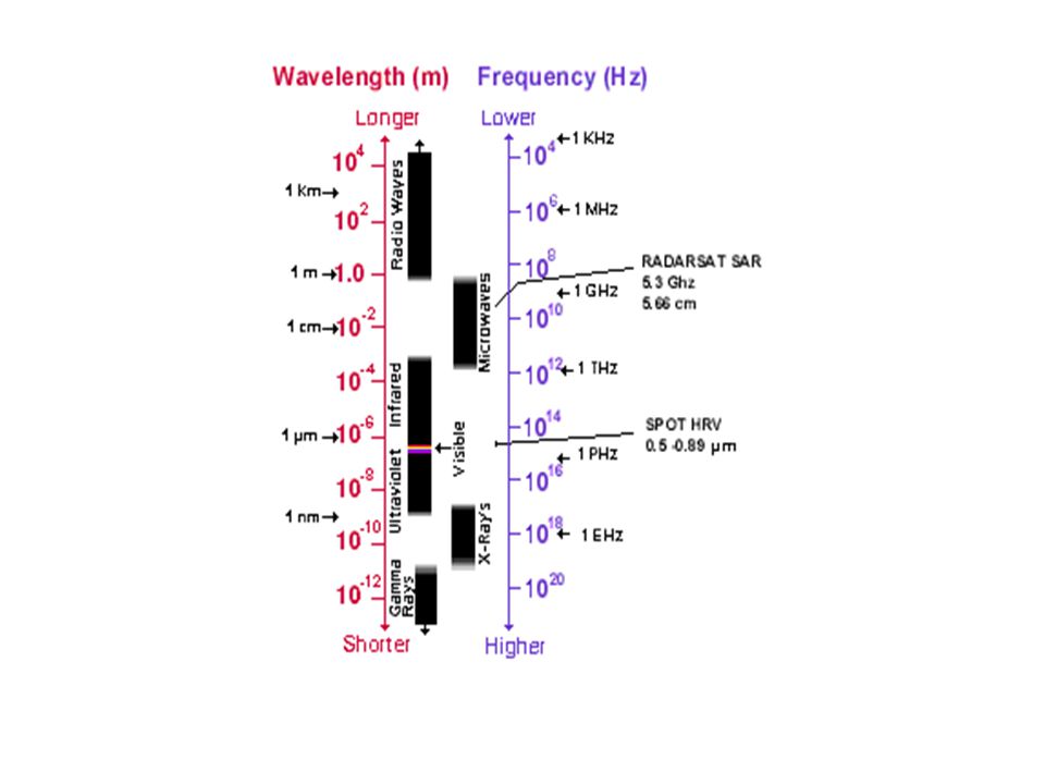
Electromagnetic spectrum Ultraviolet (UV) angstrom(Å) 10 -10 m Visible to human eye (0.4-0.7 ) RGB Infrared (0.7-1000 ) - emitted thermal radiation (temperature of objects) Microwave (0.1 mm - 100 cm)- Active system (RADAR-back scattering, SLAR)
 angstrom(Å) m Visible to human eye ( ) RGB Infrared ( ) - emitted thermal radiation (temperature of objects) Microwave (0.1 mm cm)- Active system (RADAR-back scattering, SLAR)")
14
Image recording Radiation reflected or emitted from earth surface is converted to signal (Digital Numbers- DN) The reflectance from a feature depends on the atmospheric conditions, seasons, time of a day, and physical and chemical characteristics of the feature Specular reflectance from smooth surfaces e.g. water, paved roads is lower than that from rough surfaces e.g. forest. In specular reflectance most energy scatter away from the sensor, therefore, objects like water and roads appeared as black in the image

15
Receiving station processing Archiving Distribution

16
Remote sensing basic processes

17
Selection of a remote sensing system Selection of a remote sensing system is a compromise between: –primary sources of EM energy –atmospheric windows –spectral characteristics of surface being sensed –spectral sensitivity of sensors available

19
Advantages of remote sensing Provides a regional view (large areas) Provides repetitive looks at the same area Remote sensors "see" over a broader portion of the spectrum than the human eye Sensors can focus in on a very specific bandwidth in an image or a number of bandwidths simultaneously Provides geo-referenced, digital, data Some remote sensors operate in all seasons, at night, and in bad weather
 Provides repetitive looks at the same area Remote sensors see over a broader portion of the spectrum than the human eye Sensors can focus in on a very specific bandwidth in an image or a number of bandwidths simultaneously Provides geo-referenced, digital, data Some remote sensors operate in all seasons, at night, and in bad weather")
20
Remote sensing applications Land-use mapping Forest and agriculture applications Telecommunication planning Environmental applications Hydrology and coastal mapping Urban planning Emergencies and Hazards Global change and Meteorology

21
World vegetation 1999

22
World vegetation 2000-2001 Source: http://www.spotimaging.fr

Similar presentations