Download presentation
Presentation is loading. Please wait.

1
WFM 6202: Remote Sensing and GIS in Water Management Course Project on Developing and updating empirical methods for predicting morphological changes of the Jamuna River Presented by: M. Najmul Islam & Sultana Taufika Akter

2
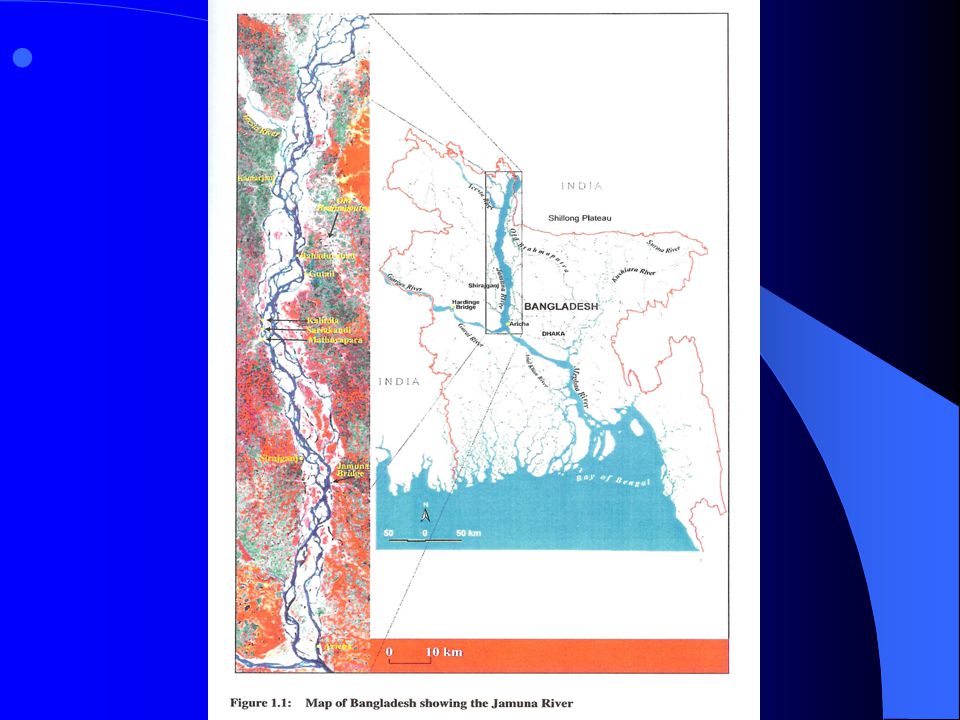
INTRODUCTION Jamuna River has one of the largest braided rivers in the world. It has enormous impacts on the lives of the people and environment. The dynamics of the river can be appreciated from the following information. INTRODUCTION Jamuna River has one of the largest braided rivers in the world. It has enormous impacts on the lives of the people and environment. The dynamics of the river can be appreciated from the following information.

3
The average increase in the width of the 240 km long stretch of the river covering the period from 1973 to 2000 was about 128 m/y. > As a result, the river area has been increased from 170,280 ha in 1973 to 240,510 ha in 2000. This implies that the average floodplain loss during the period was about 2,600 ha/y.

4
The annual accretion of char land during the same period was only about 450 ha/y. > The bend-averaged bank erosion rate at meander bends in the major and a branches of the river ranges from 0-500m/y. > In extreme cases it even exceeds 1,000 m/y.

5
Studies carried out in 1993 by the Irrigation Support Project for Asia and the Near East (ISPAN) showed that out of 1.9 million people living in the Jamuna floodplains, 0.45 million live on riverine chars within the bank lines others within a kilometer from the riverbank. Thus the dynamics of the river, especially the high magnitude of bank and char erosion, have direct impact on the displacement and landlessness of many people.

6
OBJECTIVE The specific objectives are to improve the capacity to predict the morphological behavior of the Jamuna River using spatial data with GIS (Geographical Information System). improve the morphological prediction methods by re- driving predictions from a data set that has been extended with recent data. OBJECTIVE The specific objectives are to improve the capacity to predict the morphological behavior of the Jamuna River using spatial data with GIS (Geographical Information System). improve the morphological prediction methods by re- driving predictions from a data set that has been extended with recent data.
. improve the morphological prediction methods by re- driving predictions from a data set that has been extended with recent data..")
8
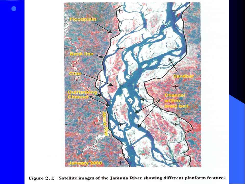
METHODOLOGY OF THE STUDY METHODOLOGY OF THE STUDY The prediction methods developed through the different previous studies were used to select the different location and to define the different morphological parameters. To provide an idea regarding the plan form, the water levels of the Jamuna River measured at Bahadurabad by image acquisition. Processing and analysis of the satellite images were performed using the computer.

10
The ERDAS Imagine and GIS ARC/INFO software were used for image processing and GIS analysis. In GIS analysis, various land coverage were overlapped and finally presented using GIS ARC/VIEW software. The digital satellite images were classified using image- processing techniques. The land cover was grouped into three broad classes: water, sand and land (including cultivated/vegetated land). In addition to the satellite images covering the period 1992 to 2000, the time series of discharge and water level data of the Jamuna River were used. The Bangladesh Water Development Board (BWDB) measures daily water levels at different stations along the Jamuna River. Water levels measured at Bahadurabad on image acquisition dates are considered representative for the whole river.
. In addition to the satellite images covering the period 1992 to 2000, the time series of discharge and water level data of the Jamuna River were used. The Bangladesh Water Development Board (BWDB) measures daily water levels at different stations along the Jamuna River. Water levels measured at Bahadurabad on image acquisition dates are considered representative for the whole river..")
11
RESULTS AND DISCUSSIONS The highly dynamic nature of the Jamuna River not only causes suffering to floodplain dwellers but national losses as well, by eroding cultivated land, settlements, commercial centers and infrastructure. Predictions are needed on plan form developments of the river as a whole, including the migration and bank erosion and on detailed morphological processes. Empirical methods are used for plan form prediction. These methods are based on observed data.

12
This study focused on improving empirical predictions, which were being developed for the Jamuna River at the beginning of the nineties. These empirical approaches depend strongly on Remote Sensing data. In this respect the last decade has provided a wealth of information, which has enabled a better specification of the governing parameters for channel migration, and bank erosion. It has been observed from reviewing previous bank erosion data and from the present analysis that the direction of the outward migration of banks depends on the approach of the main flow towards the downstream directions (see figure 3.2a), but in the Jamuna River a shift in lateral and upstream direction is not unusual either (see figure 3.2b).
, but in the Jamuna River a shift in lateral and upstream direction is not unusual either (see figure 3.2b)..")
13
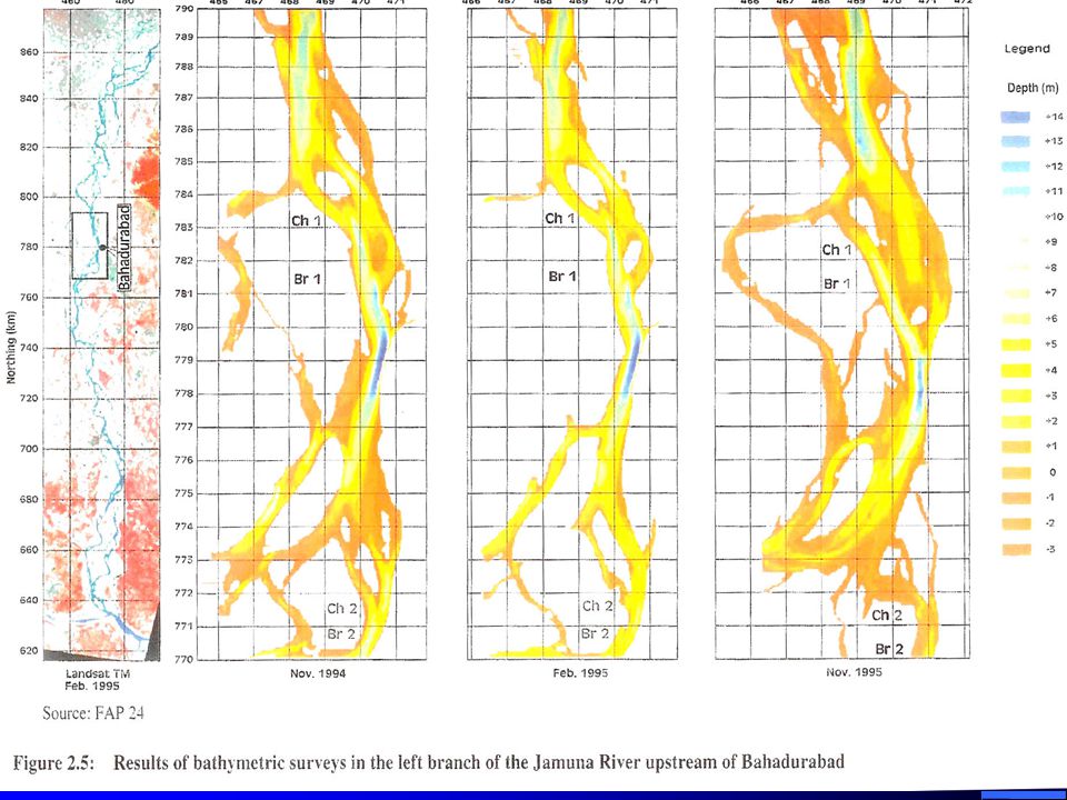
Analysis of a large number of good quality data has improved the empirical prediction. During the re- derivation or updating of the existing tools, some parameters were redefined like the bend-average erosion; bend against and along valley slope. These make the predictions better for practical use. The surveys of FAP 24 show that the channel l Ch1 remained active during the period November 1994 to February 1995 (see figure 3.1), eroding along its outer bank, while simultaneous accretion occurred along its inner bank. This erosion produced a sharpened bar at ‘A’.
, eroding along its outer bank, while simultaneous accretion occurred along its inner bank. This erosion produced a sharpened bar at ‘A’..")
15
Subsequently, the survey of November 1995 shows dramatic erosion along the outer bank of Ch1 with a maximum value of about 1 km at the location of the sharpened bar. Although the channel Ch1 lost its importance altogether during the 1995 monsoon, this significant erosion was obviously important enough to be predicted. Analysis of data showed that the use of these features in predicting morphological developments add a new dimension to the knowledge on river morphology and opens a new window for further development. The study should be considered a first step in understanding the morphological process related to the sedimentary features.

17
CONCLUSIONS The present use of empirical predictions to predict morphological changes of the rivers is mainly related to maintaining bank protection structures and for selecting suitable sites for further structures. The improved version of the predictions can be effectively used to warm the flood plain dwellers against bank erosion along the Jamuna River, which is a cause of great suffering to those people every year. Intensive application of these empirical predictions in the river will help to further improve the methods.

18
THANKS FOR JOINNING WITH US

Similar presentations