Download presentation
Presentation is loading. Please wait.

1
NATS 101 Lecture 23 Fronts

2
Review Air Masses Large regions with “uniform” temperature and moisture distributions and distinctive weather Classified by Source Region Continental (c) or Maritime (m) Polar (P) or Tropical (T) Source Regions Big in area (>1600 km by 1600 km) Dominated by light winds (long resident times)
 or Maritime (m) Polar (P) or Tropical (T) Source Regions Big in area (>1600 km by 1600 km) Dominated by light winds (long resident times)")
3
Air Mass Characteristics Ahrens Table 8.1

4
Air Mass Source Regions Ahrens Fig 8.2

5
Creation of mP Air Mass Lutgens & Tarbuck, p 230 Air masses can rapidly modify when they travel over another source region!

6
Lake Effect Snows As cP air flows over the warmer, open Great Lakes, it is warmed and moistened. When the modified cP air flows onshore, prodigious snows of several feet can result. Lutgens & Tarbuck, p 230 ~100 km

9
Weather Map with Air Masses, Fronts, Extratropical Cyclone Ahrens Fig 8.11

10
Extratropical Cyclones and Fronts In mid-latitudes, significant weather is often associated with a particular type of storm: Extratropical Cyclone Cyclone denotes the circulation around a low pressure center The energy for extratropical cyclones comes from horizontal temperature contrasts

11
Extratropical Cyclones and Fronts ET cyclones often form on a boundary between a warm and cold air mass, associated with the jet stream They tend to focus temperature contrasts along frontal zones, bands of very rapid horizontal temperature changes

12
Extratropical Cyclones and Fronts Strongest temperature gradients occur at warm edge of frontal zone, called a front There are four types of fronts Classified by their movement Each has its own symbol, color scheme Cold, Warm, Stationary, Occluded

13
Frontal Types Cold-cold air advances, warm air retreats 0oC0oC 5oC5oC -5 o C -10 o C Surface Wind Frontal Motion COLD WARM Cold Front Animation Strong Thermal Contrast Homogeneous

14
Frontal Types Warm-warm air advances, cold air retreats 0oC0oC 5oC5oC -5 o C -10 o C Surface Wind Frontal Motion COLD WARM Warm Front Animation Strong Thermal Contrast Homogeneous

15
Frontal Types Stationary-neither air mass advances significantly Surface Wind Frontal Motion 0oC0oC 5oC5oC -5 o C -10 o C WARM COLD Strong Thermal Contrast Homogeneous

16
Frontal Types Occluded-Looks like a hybrid between a cold and warm front, with warmest air along front 0oC0oC 5oC5oC -5 o C -10 o C Surface Wind Frontal Motion COLD WARM COLD Occluded Front Animation Homogeneous Strong Thermal Contrast

17
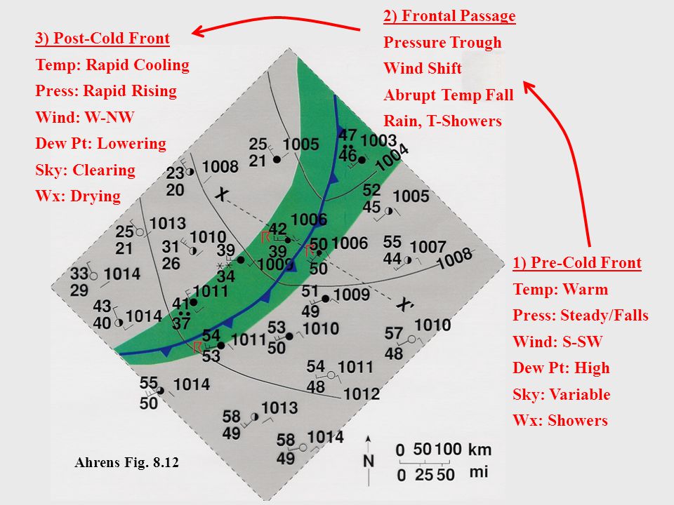
3) Post-Cold Front Temp: Rapid Cooling Press: Rapid Rising Wind: W-NW Dew Pt: Lowering Sky: Clearing Wx: Drying 1) Pre-Cold Front Temp: Warm Press: Steady/Falls Wind: S-SW Dew Pt: High Sky: Variable Wx: Showers 2) Frontal Passage Pressure Trough Wind Shift Abrupt Temp Fall Rain, T-Showers Ahrens Fig. 8.12
18
Cross-Section: Cold Front Slope = 1 in 50 Narrow band of rising warm air at cold front Widespread sinking cold air behind cold front Cumulus-type Clouds High Clouds Ahrens Fig. 8.13 Cold Front Animation

19
Typical Cold Front Weather

20
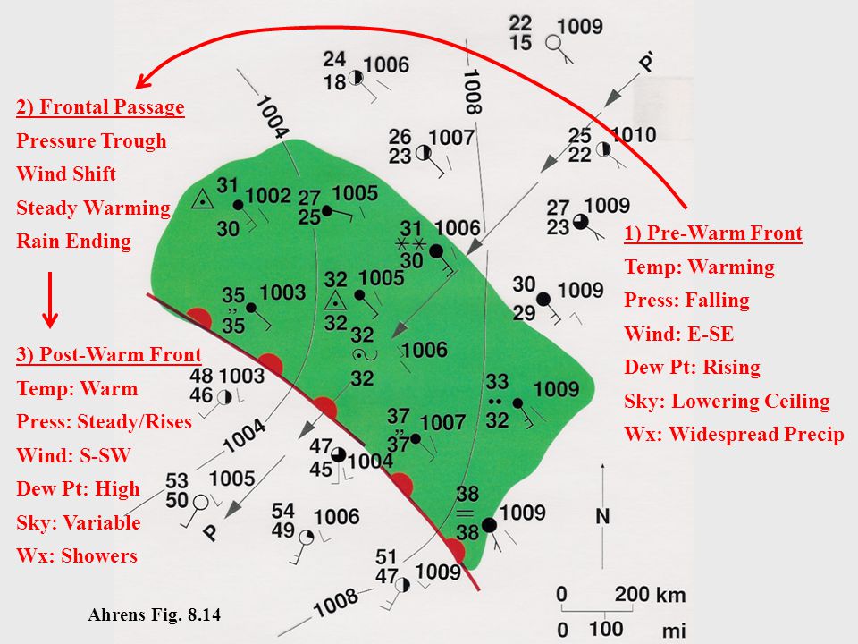
1) Pre-Warm Front Temp: Warming Press: Falling Wind: E-SE Dew Pt: Rising Sky: Lowering Ceiling Wx: Widespread Precip 3) Post-Warm Front Temp: Warm Press: Steady/Rises Wind: S-SW Dew Pt: High Sky: Variable Wx: Showers 2) Frontal Passage Pressure Trough Wind Shift Steady Warming Rain Ending Ahrens Fig. 8.14
21
Cross-Section: Warm Front Slope = 1 in 300 Widespread region of rising warm air ahead of warm front Leads to widespread region of precipitation ahead of front Low Clouds-Middle Clouds-High Clouds Ahrens Fig. 8.15 Warm Front Animation

22
Typical Warm Front Weather

23
Occluded Fronts Cold-Warm Hybrid Ahrens Fig. 8.17 and 8.18 Cold Occlusion Warm Occlusion Occluded Front Animation

24
Typical Occluded Front Weather

25
Summary Fronts ET cyclones tend to focus temperature contrasts along frontal zones Strongest temperature gradients occur at warm edge of frontal zone, called a front Fronts classified by movement, each has own symbol and characteristic weather Cold, Warm, Stationary, Occluded

26
Summary: Frontal Weather Temp: Warm Press: Steady Wind: S-SW Dew Pt: High Sky: Variable Wx: Showers Temp: Slow Warming Press: Falling Wind: E-SE Dew Pt: Rising Sky: Lowering Ceiling Wx: Precipitation, Low Vis. Temp: Rapid Cooling Press: Rapid Rising Wind: W-NW Dew Pt: Lowering Sky: Clearing Wx: Improving L

27
Summary: Frontal Weather L Temp: Rapid Cooling Press: Rapid Rising Wind: W-NW Dew Pt: Lowering Sky: Clearing Wx: Improving Temp: Slow Warming Press: Falling Wind: E-SE Dew Pt: Rising Sky: Lowering Ceiling Wx: Precipitation, Low Vis. Temp: Warm Press: Steady Wind: S-SW Dew Pt: High Sky: Variable Wx: Showers

28
Assignment for Next Lecture Topic - Extratropical Cyclone Formation Reading - Ahrens pg 219-228 Problems - 8.14, 8.15, 8.17

Similar presentations


>")


 having similar.>")


