Download presentation
Presentation is loading. Please wait.

1
Todays work Weather – next unit See syllabus Learn keywords

2
Challenge of the Weather and Climate

3
Weather Vs Climate Weather is the day to day interaction of the atmosphere. Climate is the weather over a period of years, often 30 year periods.

4
Factors affecting climate

5
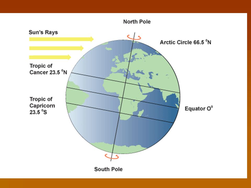
Latitude or distance from the equator Temperatures drop the further an area is from the equator. Due to the curvature of the earth. In areas closer to the poles, sunlight has a larger area of atmosphere to pass through and the sun is at a lower angle in the sky. As a result, more energy is lost and temperatures are cooler. In addition, the presence of ice and snow nearer the poles causes a higher albedo. This means that more solar energy is reflected, also contributing to the cold.albedo

10
Air Masses

12
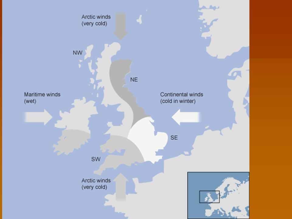
Different Air Mass = different weather The main air masses that affect Britain are those that form over the Mid-Atlantic but there are several other air masses that bring particular weather conditions. The air masses are defined according to where they originated and their course of travel. For example air from Arctic regions is classified as Arctic maritime as it originates in the Arctic and travels across the North Sea.

13
Another example is Tropical maritime air which originates near the Gulf of Mexico and travels across the warm Atlantic Ocean before arriving in Britain. Other air masses include the Polar maritime, Polar continental and Tropical continental.

14
Ocean Currents A warm ocean current called the North Atlantic drift is a major driving force, especially in the winter giving us milder temperatures than places with the same latitude eg. Moscow.

15
North Atlantic Drift

16
Prevailing Winds The prevailing wind is the most frequent wind direction a location experiences. In Britain the prevailing wind is from the southwest, which brings warm, moist air from the Atlantic Ocean. This contributes to the frequent rainfall. When prevailing winds blow over land areas, it can contribute to creating desert climates.

17
Maritime Influence Britain has a maritime climate. A warm ocean current called the North Atlantic Drift keeps Britain warmer and wetter than places in continental Europe. The sea affects the Uk climate. We live on an island, so the air above us tends to be humid (with water). This explains the mainly cloudy weather with large amounts of rainfall.
. This explains the mainly cloudy weather with large amounts of rainfall..")
19
Continentality (distance from the sea) Oceans heat up and cool down much more slowly than land. This means that coastal locations tend to be cooler in summer and warmer in winter than places inland at the same latitude and altitude. Derry, for example, is at a similar latitude to Moscow, but is much milder.

24
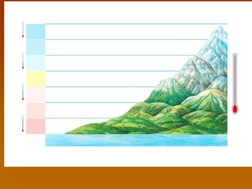
Altitude Locations at a higher altitude have colder temperatures. Temperature usually decreases by 1° C for every 100m in altitude. If it is 20 degrees at the bottom of the mountain, with the mountain 1000m high, then it will be 10 degrees at the top. Air is forced to rise up over upland areas giving them higher amounts of precipitation.

25
Types of Rainfall There are 3 types: 1.Convectional 2.Relief 3.Frontal (Depressions)
")
27
Stage 1. The sun heats the ground and warm air rises. Stage 2 As the air rises it cools and water vapour condenses to form clouds. Stage 3. When the condensation point is reached large cumulonimbus clouds are formed. Stage 4. Heavy rain storms occur. These usually include thunder and lightening due to the electrical charge created by unstable conditions.

29
Stage 1. Warm wet air is forced to rise over high land. Stage 2. As the air rises it cools and condenses. Clouds form and precipitation occurs. Stage 3. The drier air descends and warms. Stage 4. Any moisure in the air (e.g. cloud) evaporates.
 evaporates..")
31
Stage 1. An area of warm air meets and area of cold air. Stage 2. The warm air is forced over the cold air. Stage 3. Where the air meets the warm air is cooled and water vapour condenses. Stage 4. Clouds form and precipitation occurs.

32
What is pressure? Pressure is the weight of air pressing down on the earth's surface. Pressure varies from place to place and results in pressure systems.

33
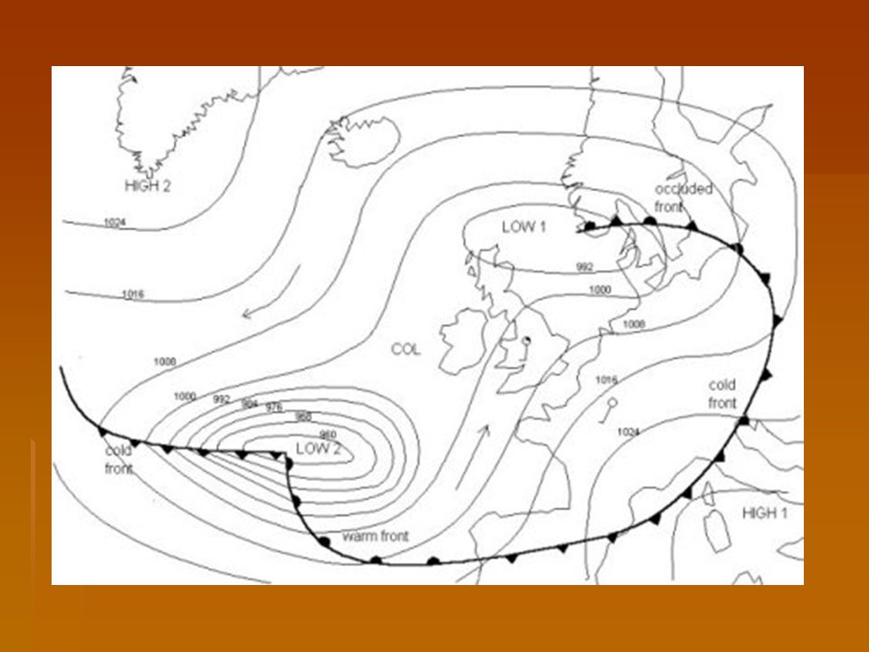
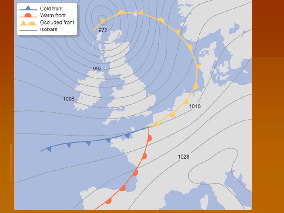
Isobars and fronts Isobars are lines on a weather map joining together places of equal atmospheric pressure. atmospheric pressure atmospheric pressure On the map the isobar marked 1004 represents an area of high pressure, while the isobar marked 976 represents an area of low pressure.

35
Note that: The numbers measure the atmospheric pressure in millibars. Usually isobars are drawn at intervals of two or four millibars (one thousandth of a bar). The closer the isobars are together the windier it is. If the lowest number is in the middle circle this is a low pressure or depression. Often low pressures mean wet and windy weather. If the highest number is in the middle circle, this is a high pressure or anticyclone. Often high pressures mean dry, sunny weather. Air pressure tends to range from 890mb (a hurricane) to 1060mb (an anticyclone).
. The closer the isobars are together the windier it is. If the lowest number is in the middle circle this is a low pressure or depression. Often low pressures mean wet and windy weather. If the highest number is in the middle circle, this is a high pressure or anticyclone. Often high pressures mean dry, sunny weather. Air pressure tends to range from 890mb (a hurricane) to 1060mb (an anticyclone)..")
38
Synoptic charts

42
3 types of front Note the three different kinds of front shown on the map - a cold front, a warm front and an occluded front. Fronts occur where two different air masses meet. air massesair masses Occluded fronts occur at the point where a cold front takes over a warm front or vice versa. If a cold front undercuts a warm front it is known as a cold occlusion and if the cold front rises over the warm front it is called a warm occlusion. Occluded fronts bring changeable weather conditions. On a synoptic chart occluded fronts are represented by semi-circles and triangles positioned next to each other. The triangles are in blue and the semicircles are in red, or both are purple (mixing both red and blue colours together).
..")
43
Warm Front Warm fronts are formed when warm air rises over a mass of cold air. As the air lifts into regions of lower pressure, it expands, cools and condenses the water vapour as wide, flat sheets of cloud. Warm fronts are shown on synoptic charts by a solid line with semicircles pointing towards the colder air and in the direction of movement. On coloured weather maps, a warm front is drawn with a solid red line with red semicircles. synoptic chartssynoptic charts

44
Cold Front Cold fronts are usually associated with depressions. depressions A cold front is the transition zone where a cold air mass is replacing the warmer air mass. The cold air is following the warm air and gradually moves underneath the warmer air. When the warm air is pushed upwards it will rain heavily.

45
Weather with a cold front passing over Often more rain will fall in the few minutes the cold front passes than it will during the whole passage of a warm front. As the cold front passes, the clouds roll by and the air temperature is cooler.

46
Cold fronts are shown on synoptic charts by a solid line with triangles along the front pointing towards the warmer air and in the direction of movement. On coloured weather maps, a cold front is drawn with a solid blue line with blue triangles.

47
Occluded Fronts Occluded fronts occur at the point where a cold front takes over a warm front or vice versa. If a cold front undercuts a warm front it is known as a cold occlusion and if the cold front rises over the warm front it is called a warm occlusion. Occluded fronts bring changeable weather conditions.

48
On a synoptic chart occluded fronts are represented by semi-circles and triangles positioned next to each other. The triangles are in blue and the semicircles are in red, or both are purple (mixing both red and blue colours together).
..")
50
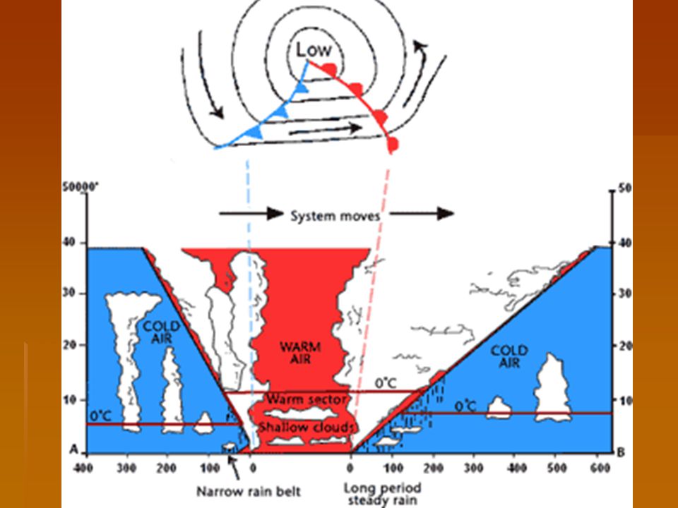
Depressions

54
http://www.echalk.co.uk/Geography/geog raphyContent.htm http://www.echalk.co.uk/Geography/geog raphyContent.htm http://www.echalk.co.uk/Geography/geog raphyContent.htm http://www.interactiveteachingresources. com/tag/weather http://www.interactiveteachingresources. com/tag/weather http://www.interactiveteachingresources. com/tag/weather

55
Depressions are areas of low atmospheric pressure which produce cloudy, rainy and windy weather. atmospheric pressure atmospheric pressure These low-pressure systems often begin in the Atlantic, moving eastwards towards the UK. They are responsible for the UK's changeable weather.

60
Warm Front

61
At the Warm Front At the warm front, lighter, warmer air from the south (tropical maritime air) meets cooler air from the north (polar maritime air) and rises gradually over it. tropical maritime airpolar maritime airtropical maritime airpolar maritime air As the warm air slowly rises it cools, its water content condenses and clouds form (nimbostratus then altostratus). The result is steady rain, later giving way to drizzle and finally clearer skies with high cirrus clouds. nimbostratusaltostratuscirrusnimbostratusaltostratuscirrus
. The result is steady rain, later giving way to drizzle and finally clearer skies with high cirrus clouds. nimbostratusaltostratuscirrusnimbostratusaltostratuscirrus.")
62
In the Warm sector Behind the warm front is an area of warm, rising air and low pressure - the centre of the low-pressure system. As this part of the depression passes over, there may be a short period of clear, dry weather

63
Cold Front

64
At the Cold Front However, at the trailing cold front, heavier, cooler air meets the warm air at the centre of the depression, undercutting it and forcing it steeply upwards. Quickly moving air masses produce high winds and cooler temperatures... As the rapidly rising warm air cools, its water condenses and clouds form (cumulonimbus, then cumulus). The result is heavy rain or thunderstorms, giving way to showers and finally to clear skies as the cold front moves away eastwards. cumulonimbus cumuluscumulonimbus cumulus
. The result is heavy rain or thunderstorms, giving way to showers and finally to clear skies as the cold front moves away eastwards. cumulonimbus cumuluscumulonimbus cumulus.")
66
Occluded Front - Depression

67
Anticyclones Anticyclones are the opposite of depressions – they are an area of high atmospheric pressure where the air is sinking.depressions As the air is sinking, not rising, no clouds or rain are formed. This is because as the air sinks it warms - meaning it can hold more water.

70
Anticyclones

73
What type of weather do Anticyclones bring? The absence of fronts means winds may be very light. Consequently, high-pressure areas are often associated with settled, dry and bright conditions.

74
Summer Vs Winter In summer, anticyclones bring dry, hot weather. In winter, clear skies may bring cold nights and frost. In cold conditions, anticyclones may also bring fog and mist. This is because the cold forces moisture in the air to condense at low altitudes. condense

Similar presentations