Download presentation
Presentation is loading. Please wait.

1
Global Mapping and Global Clearinghouse initiative International Steering Committee for Global Mapping (ISCGM) Open Seminar on Implementation Models of APSDI Clearinghouse April 17, 2002
 Open Seminar on Implementation Models of APSDI Clearinghouse April 17, 2002")
2
Contents 1. SDI Initiatives and Global Map 2. Global Mapping Concept 3. History and Current Status 4. Application Example

3
SDI Initiatives and Global Map Hierarchy of SDI Initiatives ISO/TC211 Standards GSDI RSDI NSDI each country GMUNGIDBUNEP/GRID PCGIAP/APSDIPCIDEAUNCODI-Geo EuroGeographics EUROGI

4
SDI Initiatives and Global Map Cooperation with RSDI RegionOrganizationSDI Initiative Asia/PacificPCGIAPAPSDI Europe EuroGeographicsEuroGlobalMap AmericasPCIDEA AfricaUNCODI

5
SDI Initiatives and Global Map Global Spatial Dataset DatasetOrganizationContents Global MapISCGMComplex GRIDUNEP Environment VmapNIMAMap GLCCNASA/IGBPLandcover GTOPO30USGS/EDCDEM

6
SDI Initiatives and Global Map Metadata and Clearinghouse Global Map specifications comply with the ISO/TC211 recommendations for geographic data standards Global Map specifications comply with the ISO/TC211 recommendations for geographic data standards. Clearinghouse node for Global Map is under construction.

7
Global Mapping Concepts Global Environmental Problems Air Global Warming - CO 2 Ozone Depletion Acid Rain Ecosystem in Land Deforestation Desertification, Soil Degradation, etc. Ecosystem in Ocean Oceanic Pollution Degradation of Coral Reef, etc.

8
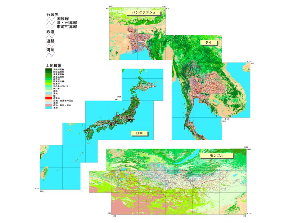
Global Mapping Concepts River and Road Network in VMAP Level 0

9
Global Mapping Concepts Shaded Map in Nepal (source GTOPO30)
")
10
Global Mapping Concepts Complexity in Global Environmental Issues Scarcity of Reliable Scientific Data Scarcity of Reliable Scientific Data Global and Long Term Process Consistency over the Whole Globe Continuity and Repetition of Data Supply Complex Processes Complex Processes Interaction among Human, Vegetation, Ocean, etc. Interdisciplinary Research Border-less Problems Border-less Problems Conflict among Parties Global Perspectives

11
Global Mapping Concepts Responsibility of National Mapping Organizations National Mapping Organizations should continuously provide core scientific geographic datasets through international cooperation with tightening user relations.

12
Agenda 21 Describes the Need of Geographic Information Currently available data is insufficient Contribution from Survey & Mapping Sector Provision of global geographic information for global environmental research and decision making Global Mapping Global Mapping Concepts Global Mapping was Proposed

13
A group of global geographic data sets of known and verified quality, with consistent specifications which are open to the public, considered a common asset of mankind and distributed worldwide at marginal cost. Global Mapping Concepts Definition of Global Map

14
Digital Geographic Dataset Digital Geographic Dataset Global Coverage The Global Map covers the whole land area. Consistent Specifications Spatial resolution: 1 km or 1:1,000,000 scale Easy Accessibility Open and worldwide distribution at marginal cost. Global Mapping Concepts Global Map - Three Principles

15
Spatial resolution: 1 km, nearly equivalent to 1:1,000,000 scale maps Data contents: raster data vector data elevation drainage elevation drainage vegetation transportation vegetation transportation land use boundaries land use boundaries land cover population center land cover population center Global Mapping Concepts Basic Specifications

16
DEM: GTOPO30 (Global 30 arc second elevation dataset) (EROS Data Center/USGS) Cartography: VMAP (Vector Map) Level 0 (US National Imagery and Mapping Agency) Land use/cover : GLCC (Global Land Cover Characterization) (EROS Data Center/USGSand IGBP DIS Land Cover WG) (EROS Data Center/USGS and IGBP DIS Land Cover WG) Global Mapping Concepts Baseline Data in Global Mapping
 (EROS Data Center/USGS) Cartography: VMAP (Vector Map) Level 0 (US National Imagery and Mapping Agency) Land use/cover : GLCC (Global Land Cover Characterization) (EROS Data Center/USGSand IGBP DIS Land Cover WG) (EROS Data Center/USGS and IGBP DIS Land Cover WG) Global Mapping Concepts Baseline Data in Global Mapping")
17
Global Mapping Concepts Global Mapping Concepts Implementation of Global Mapping Project Respective National Mapping Organizations ’ voluntary contribution Respective National Mapping Organizations ’ voluntary contribution Each NMO has responsibility for the data production Each NMO has responsibility for the data production

19
History and Current Status 1992 --- UNCED United Nations Conference on Environment and Development (UNCED), Rio de Janeiro Agenda 21 Chapter 40: A call for data at scales from local to global “ indicating the status and trends of the planet ’ s ecosystem, natural resources, pollution and socio-economic variables. ”

20
History and Current Status 1994 --- Izumo Workshop International Workshop on Global Mapping was held in Nov. 1994 in Izumo, Japan Experts from 14 countries and EU gathered Experts from 14 countries and EU gathered Resolution of Izumo Workshop was adopted Resolution of Izumo Workshop was adopted Basic Concepts of Global Mapping were agreed.

21
History and Current Status 1996 --- Tsukuba Workshop 2 nd International Workshop on Global Mapping was held in February 1996 in Tsukuba, Japan. The International Steering Committee for Global Mapping (ISCGM) was established. 1 st ISCGM Meeting was held.
 was established. 1 st ISCGM Meeting was held..")
22
History and Current Status History and Current Status International Steering Committee for Global Mapping (ISCGM) Member : 18 persons from 16 countries Member : 18 persons from 16 countries Advisor : 7 persons Advisor : 7 persons Member countries and organizations Member countries and organizations Australia, Bangladesh, Canada, China, Colombia, France, Iran, Japan, Kenya, Korea, Malaysia, New Zealand, Niger, South Africa, United Kingdom, USA, EuroGeographics, SCAR-GGI Australia, Bangladesh, Canada, China, Colombia, France, Iran, Japan, Kenya, Korea, Malaysia, New Zealand, Niger, South Africa, United Kingdom, USA, EuroGeographics, SCAR-GGI Advisory organizations Advisory organizations UN Statistics Division, UN Cartographic Section, UN Statistics Division, UN Cartographic Section, UN Environment Program, UN University, ICA UN Environment Program, UN University, ICA Secretariat : Geographical Survey Institute, Japan Secretariat : Geographical Survey Institute, Japan
 Member : 18 persons from 16 countries Member : 18 persons from 16 countries Advisor : 7 persons Advisor : 7 persons Member countries and organizations Member countries and organizations Australia, Bangladesh, Canada, China, Colombia, France, Iran, Japan, Kenya, Korea, Malaysia, New Zealand, Niger, South Africa, United Kingdom, USA, EuroGeographics, SCAR-GGI Australia, Bangladesh, Canada, China, Colombia, France, Iran, Japan, Kenya, Korea, Malaysia, New Zealand, Niger, South Africa, United Kingdom, USA, EuroGeographics, SCAR-GGI Advisory organizations Advisory organizations UN Statistics Division, UN Cartographic Section, UN Statistics Division, UN Cartographic Section, UN Environment Program, UN University, ICA UN Environment Program, UN University, ICA Secretariat : Geographical Survey Institute, Japan Secretariat : Geographical Survey Institute, Japan")
23
History and Current Status 1996 --- Santa Barbara Seminar/Meeting The Interregional Seminar on Global Mapping for Implementation of Multinational Environmental Agreements was held in Nov. 1996 in Santa Barbara, USA 2 nd ISCGM Meeting was held. Santa Barbara Statement: Need for a Global Spatial Data Infrastructure Santa Barbara Statement: Need for a Global Spatial Data Infrastructure Working Groups established (Strategic Plan, UN Special Session). Working Groups established (Strategic Plan, UN Special Session).
. Working Groups established (Strategic Plan, UN Special Session)..")
24
History and Current Status 1997 --- UN Special Session UN General Assembly, 19 th Special Session Rio+5 Summit was held in June, 1997 in NY. The adopted document includes a paragraph that states the necessity of Global Mapping.

25
History and Current Status History and Current Status From “Program for the further implementation of AGENDA21” “ A supportive environment needs to be established... to facilitate public access to information on global environmental issues... using... such tools as geographic information systems and video transmission technology, including global mapping.... ” (Paragraph 112 : Adopted document of the UN General Assembly, June 1997) “ A supportive environment needs to be established... to facilitate public access to information on global environmental issues... using... such tools as geographic information systems and video transmission technology, including global mapping.... ” (Paragraph 112 : Adopted document of the UN General Assembly, June 1997)
 A supportive environment needs to be established... to facilitate public access to information on global environmental issues... using... such tools as geographic information systems and video transmission technology, including global mapping.... (Paragraph 112 : Adopted document of the UN General Assembly, June 1997).")
26
History and Current Status 1997 --- Gifu Forum/Meeting Global Mapping Forum ‘ 97 in Gifu was held in Nov. 1997 in Gifu, Japan 3 rd ISCGM Meeting was held. Specifications Working Group established. Specifications Working Group established. Year 2000 for release of 1st version Year 2000 for release of 1st version

27
History and Current Status 1998 --- Sioux Falls Meeting 4 th ISCGM Meeting was held in June, 1998 in Sioux Falls, USA. Global Map is considered to be a foundation data set for GSDI. Global Map is considered to be a foundation data set for GSDI. National mapping organizations are to be invited to participate through the proper channels. National mapping organizations are to be invited to participate through the proper channels. Data Policy Working Group established. Data Policy Working Group established.

28
History and Current Status 1998 --- Canberra Meeting 5 th ISCGM Meeting was held in Nov, 1998 in Canberra, Australia UN supports Global Mapping UN supports Global Mapping Specifications adopted Specifications adopted Cooperation with GSDI, CEOS Cooperation with GSDI, CEOS

29
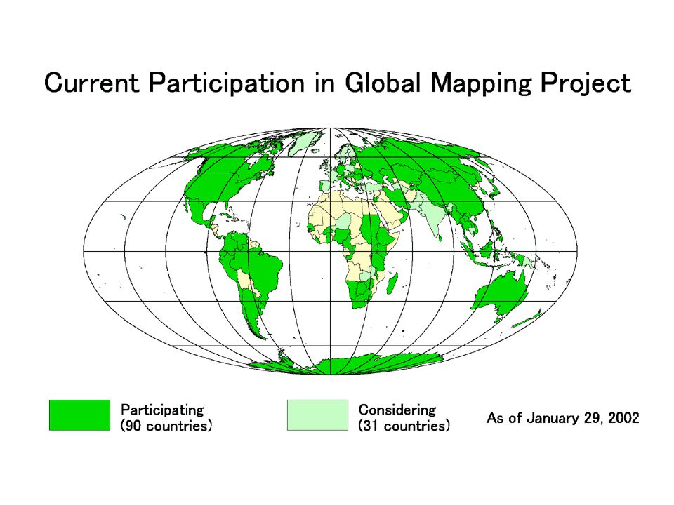
History and Current Status 1998 --- Call for Participation November 1998, UN Sent each NMO a Letter Inviting to Global Mapping Project November 1998, UN Sent each NMO a Letter Inviting to Global Mapping Project Remarkable Increase of Participation Remarkable Increase of Participation 3/4 of Global Land are Covered by Participating Countries 3/4 of Global Land are Covered by Participating Countries

31
History and Current Status 1999 --- Cambridge Meeting ä 6 th ISCGM Meeting was held in July, 1999 in Cambridge, UK. Understanding user needs essential Understanding user needs essential Relationships with other sectors of the geospatial community need to be established and maintained Relationships with other sectors of the geospatial community need to be established and maintained Private sector involvement needed Private sector involvement needed Promotional materials needed Promotional materials needed

32
History and Current Status 2000 --- Cape Town Meeting ä 7 th ISCGM Meeting was held on March, 2000 in Cape Town, South Africa Planning begins on Version 2.0 Planning begins on Version 2.0 Data policy still under discussion Data policy still under discussion Potential new layers/future additions: Potential new layers/future additions: ä MODIS land cover ä SRTM elevation data ä Land cover derived from SPOT-4 Vegetation data

33
History and Current Status 2000 --- Hiroshima Forum Global Mapping Forum 2000 in Hiroshima was held in Nov., 2000 in Hiroshima, Japan. Official website online Official website online www.iscgm.org Global Map Version 1.0 released Global Map Version 1.0 released

34
History and Current Status Global Map Version 1.0 Released November 28, 2000: Laos, Nepal, Sri Lanka, Thailand, Japan November 28, 2000: Laos, Nepal, Sri Lanka, Thailand, Japan December 25, 2000: Philippines December 25, 2000: Philippines May 18, 2001: Colombia May 18, 2001: Colombia June 28, 2001: Australia June 28, 2001: Australia July 22, 2001: Bangladesh July 22, 2001: Bangladesh December 4, 2001: Mongolia December 4, 2001: Mongolia March 28, 2002: Panama March 28, 2002: Panama Some 20 Countries Submitted draft Data to the Secretariat for Inspection Some 20 Countries Submitted draft Data to the Secretariat for Inspection

35
History and Current Status 2001 --- UN CSD-9 9 th Session of UN Commission on Sustainable Development (CSD-9) was held on April, 2001 in NY. Decision 9/4 (Information for Decision- Making and Participation) mentions the promotion of Global Mapping.
 mentions the promotion of Global Mapping..")
36
History and Current Status History and Current Status From Decision 9/4 of CSD9 “ The Commission... Calls for promoting the development and wider use by developing countries of innovative technologies such as global mapping, geographical information systems,... ” (Paragraph 2 (f) ) “ The Commission... Calls for promoting the development and wider use by developing countries of innovative technologies such as global mapping, geographical information systems,... ” (Paragraph 2 (f) )
 ) The Commission... Calls for promoting the development and wider use by developing countries of innovative technologies such as global mapping, geographical information systems,... (Paragraph 2 (f) ).")
37
History and Current Status 2001 --- Cartagena Meeting 8 th ISCGM Meeting was held in May, 2001 in Cartagena, Colombia Chair, Prof. John E. Estes, passed away in March. Chair, Prof. John E. Estes, passed away in March. Mr. Jack Dangermond of ESRI forms ISCGM/GSDI grant program. Mr. Jack Dangermond of ESRI forms ISCGM/GSDI grant program. Data policy to commercial use still under discussion Data policy to commercial use still under discussion Increase in regional organizations (PCGIAP, PC-IDEA) Increase in regional organizations (PCGIAP, PC-IDEA)
 Increase in regional organizations (PCGIAP, PC-IDEA).")
38
History and Current Status 2002 --- WSSD PrepCom II 2 nd Session of Preparatory Committee for the World Summit on Sustainable Development (WSSD PrepCom II) was held on January, 2002 in NY. Chairman ’ s paper mentions the promotion of Global Mapping.

39
History and Current Status History and Current Status From Chairman’s paper of WSSD PrepCom II “ Promote the development and wider use of satellite technology applications, including global mapping and geographic information systems, through international cooperation, to provide vital information on, for example, environmental impacts, land use and land- use changes; ” (Paragraph 28 (c) ) “ Promote the development and wider use of satellite technology applications, including global mapping and geographic information systems, through international cooperation, to provide vital information on, for example, environmental impacts, land use and land- use changes; ” (Paragraph 28 (c) )
 ) Promote the development and wider use of satellite technology applications, including global mapping and geographic information systems, through international cooperation, to provide vital information on, for example, environmental impacts, land use and land- use changes; (Paragraph 28 (c) )")
40
History and Current Status 2002 --- WSSD PrepCom III 3 rd Session of Preparatory Committee for the World Summit on Sustainable Development (WSSD PrepCom II) was held on March/April, 2002 in NY. Chairman ’ s paper mentions the promotion of Global Mapping.

41
History and Current Status 2002 (future) --- WSSD PrepCom IV 4 th Session of Preparatory Committee for the World Summit on Sustainable Development (WSSD PrepCom II) will be held on May/June, 2002 in Bali, Indonesia.
 --- WSSD PrepCom IV 4 th Session of Preparatory Committee for the World Summit on Sustainable Development (WSSD PrepCom II) will be held on May/June, 2002 in Bali, Indonesia.")
42
History and Current Status 2002 (future) --- WSSD World Summit on Sustainable Development (WSSD) will be held on August/September, 2002 in Johannesburg, South Africa. Global Map is … a significant contribution for the implementation of Agenda 21 a significant contribution for the implementation of Agenda 21 under the worldwide collaborative efforts by respective countries. under the worldwide collaborative efforts by respective countries.

43
History and Current Status 2002 (future) --- Budapest Meeting 9 th ISCGM Meeting will be held on September, 2002 in Budapest, Hungary. New Chairperson to be selected New Chairperson to be selected Phase 2 plans under discussion Phase 2 plans under discussion Potential new layers Policy

44
Application Example Application Example Purpose of the Study To use the Global Map as a means of comprehensive assessment of impacts on natural environment and local economy caused by large-scale international infrastructure construction.

45
Application Example Application Example Outline of Research The Global Map and related data on the construction project are first input. Then, impacts on environments after the construction are simulated by applied models. Also indices for the assessment of the simulation results are proposed.

46
Application Example Application Example Case Study Area Nam Kam watershed in the Mekong Basin, northeast Thailand, is adopted as a case study area because of the following reasons; 1. Some infrastructure has already been constructed and post-construction impact assessment on environment and socio-economy is available. 2. Observation points for stream-flow data, which is necessary for validation of hydro-environmental model, are well maintained. 3. Land use has been changed for the last 30 years.

47
Outline of the Mekong Basin

48
Outline of Northeast Thailand

49
Outline of Nam Kam Watershed

50
Application Example Application Example Outline of Models and Assessment Method 3 models are adopted in this study. 1. Land use model for changes in land use 2. Hydro-environmental model for water resource quantity 3. Soil-environmental model for amount of soil runoff

51
List of Application Models

52
Indices in the previous table are calculated to express the difference between environmental impacts and socio-economical effects based on the area characteristics of Nam Kam watershed. Value of Each Scenario – Minimum Value Maximum Value – Minimum Value Index Value = In Nam Kam watershed, Nam Pung dam has already been in operation as a power dam since 1965. 3 scenarios shown in the table below have been examined to estimate the land use.

53
Application Example Application Example Results of Application The application results of land use model, hydro-environmental model and socio-environmental model and also the assessment results of 4 indices are shown.

54
Land Use interpreted by LANDSAT (1995)
")
55
Area by Land Use, LANDSAT Data Reading and Estimation Results by the Model Land Use of 1995 by scenario 1 Land Use of 1995 by scenario 2 Land Use of 1995 by scenario 3

56
Monthly Evaporation ( for April ) Monthly Evaporation ( for August ) Results of Hydro-environmental Model
 Monthly Evaporation ( for August ) Results of Hydro-environmental Model")
57
Average Monthly Saturation Degree of the Top Soil Layer ( for April) Results of Hydro-environmental Model Average Monthly Saturation Degree of the Top Soil Layer ( for August)
 Results of Hydro-environmental Model Average Monthly Saturation Degree of the Top Soil Layer ( for August)")
58
Results of Hydro-environmental Model Water Resource Quantity by each Scenario

59
Results of Soil-environmental Model Calculation Results of Soil Erosion ( 1993 : ton/km2 )
")
60
Results of Soil-environmental Model Calculation Results of Soil Loss at Point S on Nam Kam River

61
Results of Comprehensive Assessment Calculation Results of Comprehensive Assessment

62
Results of Comprehensive Assessment Calculation Results of Comprehensive Assessment

63
Application Example Application Example Conclusion In this study, a comprehensive method has been adopted for the simultaneous evaluation of both environmental impacts and socio-economic effects. In this study, a comprehensive method has been adopted for the simultaneous evaluation of both environmental impacts and socio-economic effects. Combination of the Global Map data and other related data enables the method for the comprehensive assessment, which will be an effective tool for future decision-making. Combination of the Global Map data and other related data enables the method for the comprehensive assessment, which will be an effective tool for future decision-making. Infrastructure construction can bring both environmental impacts and socio-economic effects, which is the problem of watershed and basin developments of the whole world. Infrastructure construction can bring both environmental impacts and socio-economic effects, which is the problem of watershed and basin developments of the whole world. Basic Global Map data can be effectively applied for the assessment of water shed and basin development of the world and consequently contribute to the sustainable development of various areas. Basic Global Map data can be effectively applied for the assessment of water shed and basin development of the world and consequently contribute to the sustainable development of various areas.

64
Application Example Application Example Application Categories 1. Agriculture 2. Air Quality 3. Economic development and conservation 4. Emergency management 5. Fisheries 6. Forestry 7. Geology 8. Information and intelligence 9. Land use and land cover 10. Mapping, charting and geodesy 11. Marine 12. Media, press and education 13. Public health 14. Rangeland 15. Recreation and tourism 16. Transportation 17. Urban and regional planning 18. Water quality 19. Water resources 20. Weather and climate Based on categories used in: Brian C. Hadley, John E. Estes, and Joseph Scepan (2000). European and Asian Satellite Remote Sensing Applications: A Literature Review and Analysis. Santa Barbara, CA: Remote Sensing Research Unit, UCSB.
. European and Asian Satellite Remote Sensing Applications: A Literature Review and Analysis. Santa Barbara, CA: Remote Sensing Research Unit, UCSB..")
65
Thank you for your attention.

Similar presentations

 Definition of Global Map (by ISCGM) Global Map is a group of global geographic data sets of known and verified quality,>")


 International Task Team (ITT) Working Session Rama Gardens Hotel, Bangkok, Thailand September 25, 2006 Bangladesh.>")


>")


 on behalf of Rick Lawford, GEO Water CoP leader GEO Water.>")
 Tim Trainor Chief, Geography Division U.S. Census Bureau Department of Commerce.>")

 Why shape does matter Adriana Oropeza IV.>")


