Download presentation
Presentation is loading. Please wait.

1
Geographic Inquiry: Why did New Orleans Flood?

4
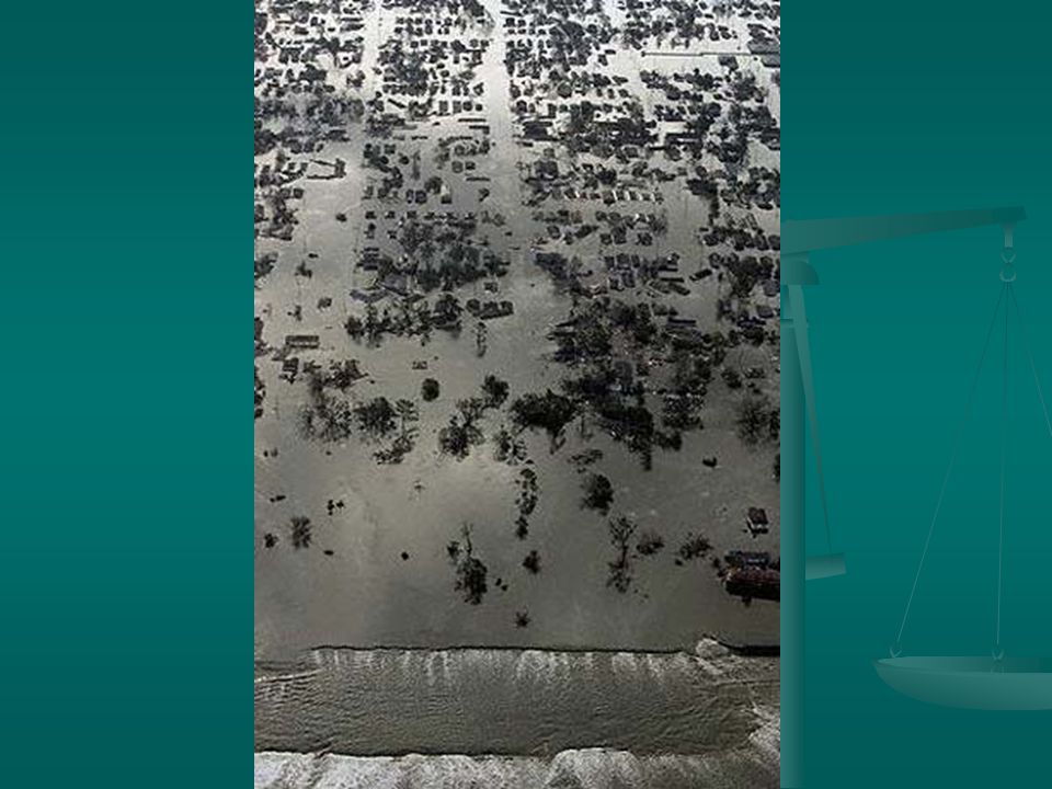
Breech in Levee

5
Exploring Geographic Data What is a levee? What is a levee? earthen structure made of clay 10 times wider base than height New Orleans has one of the most extensive levee systems in the world New Orleans has one of the most extensive levee systems in the world

6
Levees along Mississippi A levee along the Mississippi River

7
New Orleans Lies in a Bowl New Orleans lies an average of 6 ft below sea level New Orleans lies an average of 6 ft below sea level Metropolitan area surrounded by Lake Pontchartrain, the Mississippi River, and swampland extending to the Gulf of Mexico less than 100 miles South Metropolitan area surrounded by Lake Pontchartrain, the Mississippi River, and swampland extending to the Gulf of Mexico less than 100 miles South System of canals, pumps, elevated levees, and floodwalls form bowl protecting city System of canals, pumps, elevated levees, and floodwalls form bowl protecting city

9
Why City Is Sinking “Every drop of water that comes into New Orleans has to be pumped out” “Every drop of water that comes into New Orleans has to be pumped out” Large canals collect ground water so the water can be pumped out of the city Large canals collect ground water so the water can be pumped out of the city But removing ground water causes city to “settle” or sink even further But removing ground water causes city to “settle” or sink even further Places where canals connect to the river, lake are weak spots in the levee system Places where canals connect to the river, lake are weak spots in the levee system

11
Analyzing Geographic Info Levees did not fail; some flood walls failed. Levees did not fail; some flood walls failed. Locations of flood walls that failed: Locations of flood walls that failed: 17 th Street Canal London Avenue Canal Industrial Avenue Canal Can we find these areas on a map?

16
Causes of Flooding Inadequate design of flood walls: Inadequate design of flood walls: rising water in canals toppled walls because footings not sunk deep enough in ground; rising water in canals toppled walls because footings not sunk deep enough in ground; when earth became wet, pressure from water in canal caused wall to lean over when earth became wet, pressure from water in canal caused wall to lean over Inadequate maintenance Inadequate maintenance Wetland loss in the Mississippi Delta meant less protection from storm surge Wetland loss in the Mississippi Delta meant less protection from storm surge

17
Acting on What Was Learned What could be done to prevent this from happening again? What could be done to prevent this from happening again? What have other nations with similarly endangered cities done to prevent catastrophic storm surges? What have other nations with similarly endangered cities done to prevent catastrophic storm surges?

Similar presentations


 Turned into category.>")


