Download presentation
Presentation is loading. Please wait.

1
Peninsula of Peninsulas
Chapter 12 Europe Peninsula of Peninsulas

3
12/1 Landforms and Resources
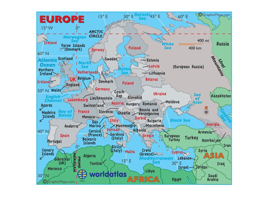
Northern Peninsulas Scandinavian Peninsula- Norway and Sweden Fjords- cut by glacial movement millions of years ago Jutland- Denmark Southern Peninsulas Iberian Peninsula- Spain-Portugal Italian Peninsula- Italy, San Marino, Vatican City Balkan Peninsula-Greece, Romania, Bulgaria, European Turkey, Serbia, Montenegro, Albania, Bosnia, +

4
Islands Great Britain- England, Scotland and Wales
(note difference between Great Britain and the United Kingdom- England, Scotland, Wales and Northern Ireland) Ireland- Republic of Ireland and Northern Ireland Greenland- not technically Europe, but owned by Denmark Iceland
 Ireland- Republic of Ireland and Northern Ireland. Greenland- not technically Europe, but owned by Denmark. Iceland.")
5
Smaller Islands United Kingdom- Channel Islands, Isle of Man(in the Irish Sea) Denmark- Faroe Islands- north of Scotland Portugal- Canary Islands (coast of Africa) and Azores- west of Portugal in the Atlantic Spain- Balearic Islands- in the Mediterranean- Majorca, Menorca, Ibiza France- Corsica Italy- Sardinia, Sicily Greece- hundreds of islands plus Crete (the largest Greek island)
 and Azores- west of Portugal in the Atlantic. Spain- Balearic Islands- in the Mediterranean- Majorca, Menorca, Ibiza. France- Corsica. Italy- Sardinia, Sicily. Greece- hundreds of islands plus Crete (the largest Greek island)")
6
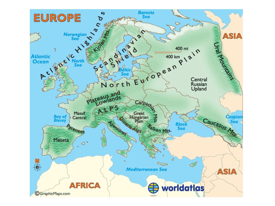
Mountain Ranges Alps- Switzerland, Germany, Austria, northern Italy- Mt. Blanc- highest point in Europe Apennine- runs down the length of Italy Balkan Mountains- cuts off the Balkan Peninsula Ural Mountains- separates European Russia from Asian Russia Pyrenees- separates Spain and France Caucasus Mountains- between Black Sea and Caspian Sea

8
Uplands Uplands are hills or very low mountains that may also contain mesas and high plateaus. Not technically mountains but higher altitude areas Examples: Scandinavia, Scottish highlands, Brittany in France, central plateau in Spain called Meseta. Massif Central in France and Central Germany.

9
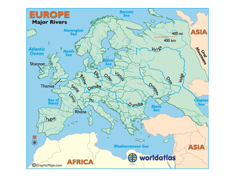
Rivers Danube- touches nine countries, links Europe to the Black Sea
Rhine- Germany and more Seine- France Rhone- France Loire- France Tagus- Portugal and Spain Tiber- Italy Thames-England Po- Italy Canal Systems link many of these rivers together.

11
Major bodies of water Atlantic Ocean Irish Sea Norwegian Sea
Baltic Sea English Channel Bay of Biscay Mediterranean Aegean Sea Ionian Sea Black Sea North Sea Adriatic Sea Straits of Gibraltar

13
Resources Coal- most of northern Europe
Industrialized areas- Ruhr valley- Northern Germany Alsace-Lorraine- (between Germany and France- and the UK- all have great access to coal and good transportation systems. Oil and natural gas- North Sea- primarily, UK, Netherland, Denmark, and Norway 33% is also good for agriculture for a variety of crops

14
Resources shape life Because Ireland lacks natural energy resources people have for centuries used peat. Peat is cut from the ground, dried and then used for fuel.

15
12/2 Climate and Vegetation
Westerly winds warm Europe Marine west coast climate- Gulf Stream ( also called the North Atlantic Drift) No large coastal mountains to block wind so it carries far inland Also carries moisture so adequate rainfall
 No large coastal mountains to block wind so it carries far inland. Also carries moisture so adequate rainfall.")
17
Harsher conditions inland
Areas farther inland have greater extremes of climate Hotter summers and colder winters- depending on their latitude Much of eastern Europe is fertile plain grow heartier crops like: wheat, potatoes, rye barley and sugar beets.

18
Sunny Mediterranean Mild climate- similar to So. Calif.
Summers are hot and dry Winters, mild and wet Special Winds: Mistral- areas not protected by mountains- cold, dry winds from the north Sirocco- hot steady wind from North Africa- pick up moisture from the Med and dust from North Africa

19
Tourism Mediterranean climate attracts many tourists from all over Europe and the world. Land of the Midnight Sun Northern Scandinavia, along the Arctic Circle lies a tundra climate: Permafrost no trees, moss and lichen. In winter the nights are long In summer, the days are long

21
Typical Tundra landscape

22
12/3 Human-Environment Interaction
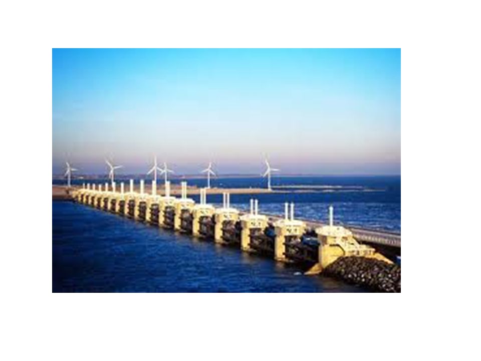
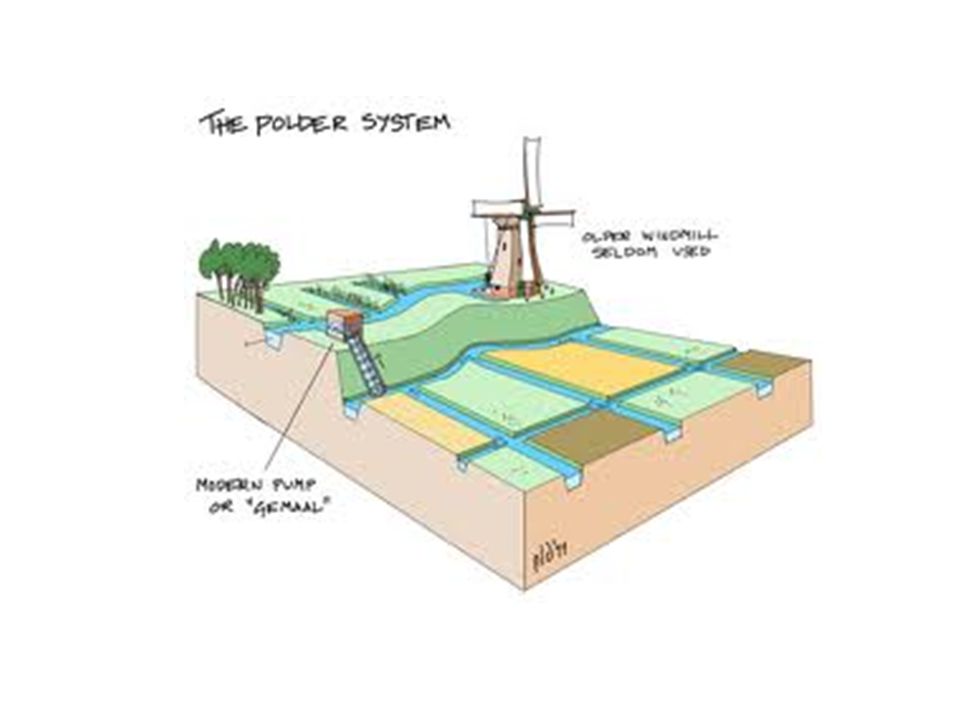
Polders- land from the sea via a system of dikes and drainage- Growing population created need for more land 40% of the Netherlands is reclaimed land. Seaworks- structures that are used to control the sea Terpen- dikes and high earthen platforms that provide places of safety during floods and high tides.

26
1400s- Use of windmills to move water
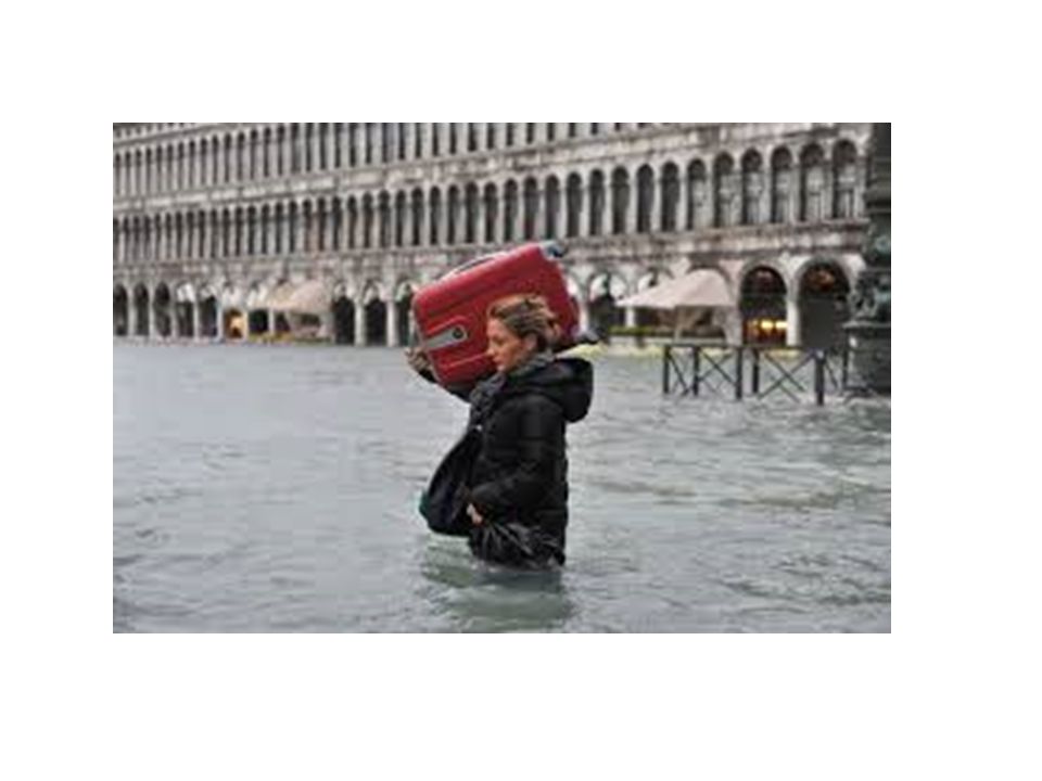
Zuider See- was a branch of the North Sea- System of dams cut it off and now it is a fresh water lake- (called Ijsselmeer) also added hundreds of square miles of land to Holland Waterways for commerce- Venice 120 island, 150 canals- North end of the Adriatic Sea at the Po River delta Venice is gradually sinking
 also added hundreds of square miles of land to Holland. Waterways for commerce- Venice. 120 island, 150 canals- North end of the Adriatic Sea at the Po River delta. Venice is gradually sinking.")
30
Deforestation Intentional deforestation- building materials, to make charcoal Acid Rain in modern times

Similar presentations


 –Eastern border is the Ural Mountains down to Caucasus and through the.>")


 Jutland Peninsula (Denmark.>")


