Download presentation
Presentation is loading. Please wait.

1
Lecture 16 - Deserts

2
Definition of Desert A desert is an area with less than 25 cm (10 inches) of annual precipitation aridity index = potential evaporation/precipitation greater than 4.0 Deserts may be cold, temperate or hot. All major continents have one type of desert or the other.

3
Wind-Swept Sand Dunes

4
Desert Life Forms (Roadrunner)
")
5
Desert Life Forms (Lizard)
")
6
Types of Deserts Desert Types - Subtropical Desert – 30 o Latitude - Deserts on Leeward side of major Mountain ranges - Interior Deserts- center of continents far from ocean - Coastal desert- prevailing onshore wind cooled by cold ocean current - Polar deserts- extremely cold and dry

7
The major wind cells Coriolis “turns” them

8
Subtropical Deserts +/- 30 o latitude

9
A Rain-Shadow Desert

10
Ocean-Current Desert

11
Also Interior and Polar Deserts

12
Desert Landscape (Features) Weathering and desert streams create Desert features Weathering in Desert is mostly mechanical - A little chemical weathering produces manganese and iron-oxide stains, called desert vanish Stream Erosion - Arroyo- channel with water during periods of high discharge but dry most part of the year - Pediments- large-scale gently inclined surfaces - Inselberg- steep-sided knob of durable rock - Playa- dry lake bed
 Weathering and desert streams create Desert features Weathering in Desert is mostly mechanical - A little chemical weathering produces manganese and iron-oxide stains, called desert vanish Stream Erosion - Arroyo- channel with water during periods of high discharge but dry most part of the year - Pediments- large-scale gently inclined surfaces - Inselberg- steep-sided knob of durable rock - Playa- dry lake bed")
13
Chemical Weathering in Deserts

14
Desert Landforms Produced By Water

15
Uluru (Ayers Rock) Inselberg
 Inselberg")
16
Playas

17
Playas (cont'd)
")
18
Playas (cont'd) – A Playa in Death Valley, California
 – A Playa in Death Valley, California")
19
Swimmers in hypersaline Dead Sea Evaporite deposits indicate a dry climate in the geologic record

20
Water-Carved Canyon

21
Work of Winds Erosion by Wind - Deflation- wind removes finer particles from the surface - Desert pavement- layer of pebbles left behind after deflation - Abrasion- sand blasting - Ventifacts- wind-shaped stones with sharp- edge faces - Yardangs- streamlined desert ridges

22
Blowout Caused by Deflation

23
Desert Pavements

24
Desert Pavements (cont'd)
")
26
Desert Pavements (cont'd) – Source: Martin Miller These make good landing strips
 – Source: Martin Miller These make good landing strips")
27
Desert Varnish slows infiltration Causes Flash Floods

28
Remnants of Wind Abrasion in addition to occasional flash flood erosion (surface grains are frosted)
")
29
Origin of Ventifacts

30
Origin of Ventifacts (cont’d) Wind
 Wind")
31
Yardangs, White Desert, Egypt

32
Transport By Wind No dissolved load Suspended Load- most consist of dust (silt, clay, pollen, bacteria, salt crystals, etc.) Bed Load- sediments moved along or near the ground –Rolling or saltation- bed loads lifted off the ground momentarily due to force of collision with other grains
 Bed Load- sediments moved along or near the ground –Rolling or saltation- bed loads lifted off the ground momentarily due to force of collision with other grains")
33
Transport of Wind-Borne Sediment Suspended Load Transports Sahara sediment to Caribbean and Amazon Rain Forest

34
Deposition of Dunes Reduced wind velocity results in sediments deposition Dunes are hills of loose wind-born sand - Size, shape, and orientation of dune are determined by available sand, vegetation, and wind

35
Beach Sand Dunes

36
Deposition of Wind’s Bed Load Rain – Shadow Desert in Lee Of Mountains

37
Large Scale Dunes (Gobi Desert)
")
38
Dune Migration Just like ripples in a stream

39
Dune Migration (cont'd)
")
40
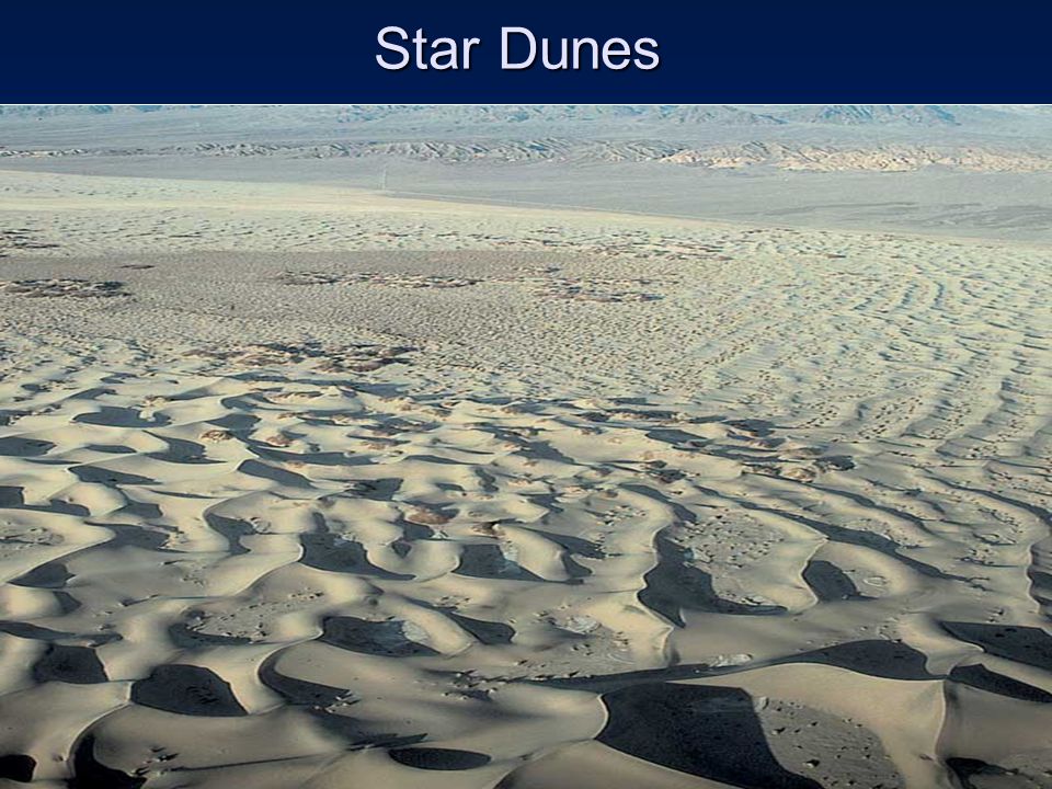
Deposition and Dune Types Dune Types - Transverse- ridges that are perpendicular to prevailing wind direction - Longitudinal- ridges that are parallel to prevailing wind direction - Barchans- crescent-shaped with horns pointing downwind - Horseshoe (Parabolic)- crescent-shaped with horns pointing upwind - Star- winds from three or more directions
- crescent-shaped with horns pointing upwind - Star- winds from three or more directions")
41
Transverse Dunes

43
Longitudinal Dunes

45
Barchan Dunes

46
Barchan Dunes in Baja California

47
Parabolic Dunes

48
Star Dunes

50
Lithified Sand Dunes (Jurassic Navajo Sandstone)
")
51
Loess Loess formed by windblown deposits of glacial outwash silt Loess from the Columbia River Basin

52
Desertification Desertification- invasion of desert conditions into formerly non-desert areas Drought and overpopulation are main causes Signs - Lowering of water table - Marked reduction of water supply - Increased salinity in water and soil - Progressive destruction of native vegetation - Accelerated soil erosion

53
Map of the Sahel

54
End of Lecture 16

Similar presentations