Download presentation
Presentation is loading. Please wait.

1
Active Fire Detection using Geostationary Satellites L. Giglio SSAI/University of Maryland GOFC Global Geostationary Fire Monitoring Applications Workshop 23-25 March 2004

2
Overview Satellite-based fire detection algorithms Generic issues related to multi-satellite fire monitoring Polar vs. geostationary satellite suite comparison –Issues –Biases

3
Introduction Multiple systems currently providing active fire data and new systems are being planned Different systems offer different capabilities –Different detection capabilities (spatial/temporal) –Different fire monitoring groups using different methods and different algorithms Accuracy of the different systems not well quantified –Systematic validation activities being initiated User community is starting to combine data from these multiple systems – complementary data sets
 –Different fire monitoring groups using different methods and different algorithms Accuracy of the different systems not well quantified –Systematic validation activities being initiated User community is starting to combine data from these multiple systems – complementary data sets")
4
Satellite-Based Fire Detection Algorithms Virtually all exploit tremendous radiative energy emitted at ≈4 µm, usually in conjunction with a longer wavelength ≈10 µm band –Exception is DMSP-OLS ABBA/WF-ABBA (Prins et al.) are the premier detection algorithms for geostationary satellite instruments –GOES VAS, GOES Imager Detection principals are well-described elsewhere
 are the premier detection algorithms for geostationary satellite instruments –GOES VAS, GOES Imager Detection principals are well-described elsewhere")
5
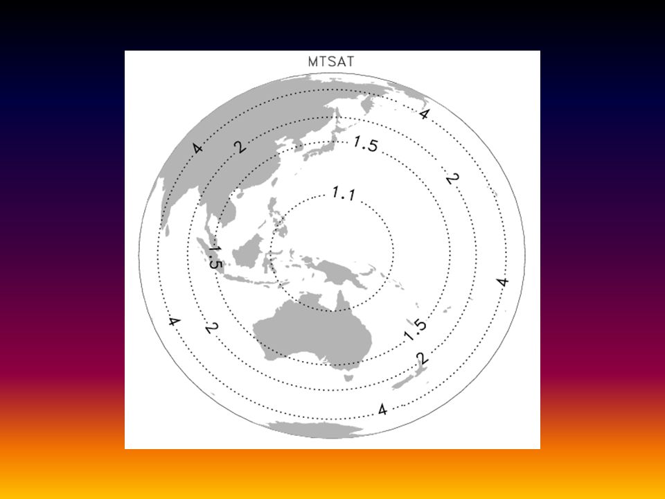
Geostationary Satellite Suite GOES-8 –1995-2003 GOES-10 –1998 onward GOES-12 –2003 onward MSG-1 –2003 onward MTSAT –Late 2004

6
GOES-EGOES-WMSGMTSAT 0-40-80-120-16040 80120160 80 60 40 20 0 -20 -40 -60 -80 Satellite View Angle 80° 65° 322 International Global Geostationary Active Fire Monitoring: Geographical Coverage

7
Multi-Satellite Fire Monitoring: Generic Issues Systems have –Different spatial resolutions –Different radiometric characteristics –Different temporal sampling How do we combine observations from multiple instruments in a consistent, meaningful manner?

8
Polar Fire Monitoring: Strengths and Weaknesses Strengths –Global coverage Frequency of global coverage depends on scan width –Higher spatial resolution Moderate resolution – AVHRR, MODIS (1 km) High resolution – Landsat, ASTER (30 m) Weaknesses –Fewer opportunities for cloud-free observations MODIS Terra/Aqua give four observations per 24 hrs –Greater variance in envelope of detectable fires (off nadir vs. nadir) –Temporal sampling issues related to diurnal fire cycle
 –Temporal sampling issues related to diurnal fire cycle.")
9
Theoretical Detection Envelope MODIS Temperate deciduous rainforest Night 0° scan angle Summer No background fires

10
Geostationary Fire Monitoring Suite: Strengths and Weaknesses Current Strengths –Hemispheric fire monitoring –Near-real time data for fire management –Few/no temporal sampling issues related to diurnal fire cycle –Broad Direct Broadcast capability Current Weaknesses –Gaps in global spatial coverage –Spatial biases in envelope of detectable fires

11
Potential Gaps in Spatial Coverage

12
Spatial Biases in Envelope of Detectable Fires (1 of 2) For instruments on board geostationary satellites, pixel size varies as a function of distance from the sub-satellite point –Introduces spatial gradient in the envelope of detectable fires
 For instruments on board geostationary satellites, pixel size varies as a function of distance from the sub-satellite point –Introduces spatial gradient in the envelope of detectable fires")
13
Size of footprint relative to footprint size at sub- satellite point.

17
Spatial Biases in Envelope of Detectable Fires (2 of 2) Complicates comparison of fire activity in different regions, even using a single satellite Not an issue for near-real time fire monitoring Will need to be addressed in production of a global data set
 Complicates comparison of fire activity in different regions, even using a single satellite Not an issue for near-real time fire monitoring Will need to be addressed in production of a global data set")
18
ASTER Scene 2.4 µm R 1.6 µm G 0.5 µm B High resolution sensors can provide much- needed fire size distributions.

19
Size Distribution of Active Fires

20
Morisette et al., in press. Southern Africa, 2000

21
GOES Diurnal Cycle Research Issue How to merge different sampling of diurnal fire cycle? –Temporal sampling exhibits a spatial dependence since local time varies with longitude –What impact does this have on the number of fires detected when combined with the spatial variation in detection envelope?

22
TRMM VIRS Diurnal Fire Cycle Borneo 1999-2001

23
GOES Local Sampling Time: Function of Longitude

24
Summary Geostationary satellite suite will provide a major contribution to global fire monitoring capability Ultimately envision merging both polar-orbiting and geostationary fire data sets to exploit strengths of each Interesting research opportunities in addressing potential issues

Similar presentations


 in North and South America Joleen M. Feltz *, Michel Moreau ^, Elaine M. Prins +, Kirsten.>")


 Review 09 – 11 March 2010 NOAA Operational Geostationary Sea Surface Temperature Products from NOAA.>")