Download presentation
Presentation is loading. Please wait.

2
Air masses and fronts Textbook, Chapter 9

3
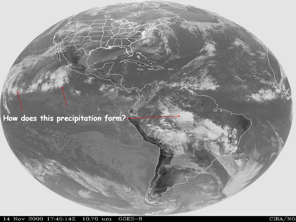
DiscussionHow do precipitation systems form?

5
How does this precipitation form?

6
mountains

7
How does this precip form?

8
How does this storm form? let’s revisit the lifting mechanisms …

9
Five Mechanisms 1. Convective ascent Cumulus clouds … spontaneous buoyant

10
The 4 other mechanisms are forced ascent … (a) over a mountain (b) or a front
 over a mountain (b) or a front")
11
(c) Convergence into surface low
 Convergence into surface low")
12
(d) Uplift forced by jet stream Upper-level divergence
 Uplift forced by jet stream Upper-level divergence")
13
Areas of jet-stream driven ascent

14
Cloud & precipitation formation mechanisms Buoyant ascent [bubble ascent] Forced ascent [layer ascent] a)Orographic b)Frontal c)Low-level convergence (friction) d)Upper-level divergence (jet stream) Many clouds are the result of several simultaneous processes.
![Cloud & precipitation formation mechanisms Buoyant ascent [bubble ascent] Forced ascent [layer ascent] a)Orographic b)Frontal c)Low-level convergence (friction) d)Upper-level divergence (jet stream) Many clouds are the result of several simultaneous processes.](http://images.slideplayer.com/14/4204188/slides/slide_14.jpg "Cloud & precipitation formation mechanisms Buoyant ascent [bubble ascent] Forced ascent [layer ascent] a)Orographic b)Frontal c)Low-level convergence (friction) d)Upper-level divergence (jet stream) Many clouds are the result of several simultaneous processes.")
15
1. Buoyant ascent

16
We’ve talked about stability and parcel ascent (Chapter 4, Lab 7). Remember that in a conditionally unstable atmosphere, a cloud will continue to rise as long as its core temperature exceeds that of the surroundings 1. Buoyant ascent

17
cumulus growth stable environmental lapse rate stable conditionally unstable stable condi- tionally unstable moist dry Cumulus humilis Cumulus congestus Cumulonimbus

18
Lifting up a mountain may cause destabilization, …which is why Cu clouds first form there

19
Cloud & precipitation formation mechanisms Buoyant ascent [bubble ascent] Forced ascent [layer ascent] a)Orographic b)Frontal c)Low-level convergence (friction) d)Upper-level divergence (jet stream) Many clouds are the result of several simultaneous processes.
![Cloud & precipitation formation mechanisms Buoyant ascent [bubble ascent] Forced ascent [layer ascent] a)Orographic b)Frontal c)Low-level convergence (friction) d)Upper-level divergence (jet stream) Many clouds are the result of several simultaneous processes.](http://images.slideplayer.com/14/4204188/slides/slide_19.jpg "Cloud & precipitation formation mechanisms Buoyant ascent [bubble ascent] Forced ascent [layer ascent] a)Orographic b)Frontal c)Low-level convergence (friction) d)Upper-level divergence (jet stream) Many clouds are the result of several simultaneous processes.")
20
(a) Orographic clouds Altocumulus lenticularis, Greenland
 Orographic clouds Altocumulus lenticularis, Greenland")
21
Quantifying the Foehn effect The Foehn or Chinook effect (web link)
")
22
Foehn Effect -4ºC 4ºC 12ºC environmental temperature windward slopeleeward slope T T d 20ºC 1228 4 8, 0 -2, -2 4, 4 10, 10 rainshadow e.g, Rocky Mt. Chinook winds Higher temperatures on the leeward side of mountains occur because latent heat is released (condensation) and converted into sensible heat.
 and converted into sensible heat..")
23
Chinook wall cloud

24
TTdTd height of the mountain

25
Pop quiz: when a good westerly wind blows and heavy snowfall occurs over the Cascades, then in Yakima on the east side it will be ……. than in Seattle on the west side. A: sunnier but cooler B: sunnier, warmer, drier, and windier C: sunnier, cooler, more damp, and calmer D: cloudier, cooler, more damp, and windier. Seattle Yakima

26
Cloud & precipitation formation mechanisms Buoyant ascent [bubble ascent] Forced ascent [layer ascent] a)Orographic b)Frontal c)Low-level convergence (friction) d)Upper-level divergence (jet stream)
![Cloud & precipitation formation mechanisms Buoyant ascent [bubble ascent] Forced ascent [layer ascent] a)Orographic b)Frontal c)Low-level convergence (friction) d)Upper-level divergence (jet stream)](http://images.slideplayer.com/14/4204188/slides/slide_26.jpg "Cloud & precipitation formation mechanisms Buoyant ascent [bubble ascent] Forced ascent [layer ascent] a)Orographic b)Frontal c)Low-level convergence (friction) d)Upper-level divergence (jet stream)")
27
(b) Uplift along fronts A front is a sudden transition between airmasses
 Uplift along fronts A front is a sudden transition between airmasses")
28
Fronts separate airmasses

29
continental maritime cP cT mP mT Types of airmasses polar tropical

30
Fig. 9.3

31
Fig. 9.4

32
Air masses have distinct lapse rates, and therefore also distinct cloud and precipitation characteristics

33
Pop quiz: what airmass is this ? cP cT mP mT

34
Pop quiz: what airmass is this ? cP cT mP mT

35
Pop quiz: what airmass is this ? cP cT mP mT Hint: this happens in winter

36
Warm fronts The cold air recedes …

37
Warm front clouds Where is the cold air??

38
Fig. 9.16

39
Cold fronts

40
Cold front clouds light rain or dry (1)stable air ahead of cold front (2) unstable air ahead of cold front
stable air ahead of cold front (2) unstable air ahead of cold front")
41
Fig. 9.14

42
Occluded fronts Stage IStage II

43
Cross section through an occluded front

44
Fig. 9.18 (western US) (eastern US) Cold occlusion Warm occlusion
 (eastern US) Cold occlusion Warm occlusion")
45
Stationary fronts Current analysis

46
3D view of fronts during the evolution of a frontal disturbance

47
drylines Thunderstorms, sometimes severe ones, can be triggered along the dryline.

48
Superstorm of 12 March 1993 Locate the front(s)
")
50
Case study: winter storm of 10-13 Dec 2000

51
Cloud & precipitation formation mechanisms Buoyant ascent [bubble ascent] Forced ascent [layer ascent] a)Orographic b)Frontal c)Low-level convergence (friction) d)Upper-level divergence (jet stream)
![Cloud & precipitation formation mechanisms Buoyant ascent [bubble ascent] Forced ascent [layer ascent] a)Orographic b)Frontal c)Low-level convergence (friction) d)Upper-level divergence (jet stream)](http://images.slideplayer.com/14/4204188/slides/slide_51.jpg "Cloud & precipitation formation mechanisms Buoyant ascent [bubble ascent] Forced ascent [layer ascent] a)Orographic b)Frontal c)Low-level convergence (friction) d)Upper-level divergence (jet stream)")
52
(c) Low-level convergence into lows or trofs 1)Tropical lows (hurricanes) extract their energy from latent heat release 2)Mid-latitude lows extract most of their energy from the jet stream
 Low-level convergence into lows or trofs 1)Tropical lows (hurricanes) extract their energy from latent heat release 2)Mid-latitude lows extract most of their energy from the jet stream")
53
LOW-LEVEL CONVERGENCE INTO A TROF Tropical cyclogenesis

55
Cross section thru a tropical cyclone LOW-LEVEL CONVERGENCE

56
Check out some hurricane animations

57
Tropical cyclones have different names in different oceans There spin is always cyclonic, i.e. ccw in the north and cw in the south

58
Where do hurricanes form? –Away from the equator –Where the SST is at least 80 F August SST

59
Hurricane Effects: Wind: causes most damage, but limited mortality. Storm surge: a historical killer, now mitigated by evacuation. Rain and Inland Flooding: take more lives than wind, but do less damage.

61
coastal Hurricane mortality and damage, United States 1900-2008 Hurricanes are covered in the textbook in Chapter 8

62
Lows, and convergence, uplift, clouds, and precipitation, also occur at higher latitudes. What energizes them?

63
Answer: the jet stream !! Buoyant ascent [bubble ascent] Forced ascent [layer ascent] a)Orographic b)Frontal c)Low-level convergence (friction) d)Upper-level divergence (jet stream) THIS WILL BE COVERED IN CHAPTER 10 End of Chapter 9
Orographic b)Frontal c)Low-level convergence (friction) d)Upper-level divergence (jet stream) THIS WILL BE COVERED IN CHAPTER 10 End of Chapter 9.")
Similar presentations