Download presentation
Presentation is loading. Please wait.

2
Agenda An Overview on Radio Frequency Spectrum World Division on Frequency Allocation International allocation Table/ frequency allocations to services Radio Regulations (ITU-R RR) Coordination and notification procedures National Frequency allocation Table Frequency assignment and Licensing Spectrum Management System For Developing Countries Administrative Functions Technical Functions GIS Functions
 Coordination and notification procedures National Frequency allocation Table Frequency assignment and Licensing Spectrum Management System For Developing Countries Administrative Functions Technical Functions GIS Functions")
3
Overview Frequencies & Wavelength Bands

4
Overview Propagation modes and usages for various frequency bands BandFrequencyModeRangeBW Interference Volume Usage VLF3 - 30 kHzwave guideseveral 1000 km very limited wide spreadWorldwide, long range radio navigation and strategic communications LF30 - 300 kHzground wave, sky wave several 1000 kmlimited wide spreadLong range radio navigation and strategic communications MF0.3 - 3 MHzground wave, sky wave a few 1000 km moderatewide spreadMedium range pt. to pt., broadcasting and maritime mobile HF3 - 30 MHzsky waveup to several 1000 km widewide spreadLong and short range pt. to pt., global broadcasting, mobile. VHF30 - 300 MHzspace wave, troposphere scatter, diffraction up to a few 100 km very wideconfinedShort and medium pt. to pt., mobile, LAN, audio and video broadcasting, personal communications UHF0.3 - 3 GHzspace wave, tropospheric scatter, diffraction, line-of-sight Generally less than 100 km very wideconfinedShort,medium & long pt. to pt., mobile, LAN, audio and video broadcasting, personal communications, satellite communications SHF3 - 30 GHz line-of-sight 30 km; several 1000 km for multihop and satellite very wide up to 1 GHz generally confined Medium to short range pt.to pt.,audio and video broadcasting, LAN, mobile/personal communications, satellite communications EHF30 - 300 GHzline-of-sight20 km; several 1000 km for multihop and satellite very wide up to 10 GHz generally confined Short range pt. to pt., microcellular, LAN and personal communications, satellite communications Chap. 5 SMS Handbook (At VLF a wave guide mode between the ionosphere and the Earth allows propagation over) global distances.
 global distances..")
5
Overview World division of RFS

6
Overview frequency allocations table (chart)
")
7
Overview Categories of Services & allocations Primary and secondary services Service the name of which are printed in “capitals” (example: FIXED) are called “Primary” Services Service the name of which are printed in “normal characters” (example: Mobile) are called “secondary” Services Additional remarks shall be printed in normal characters ( MOBILE except aeronautical mobile) Stations of a secondary service: Shall not cause harmful interference to stations of primary services to which frequencies are already assigned or may be assigned at a later date; cannot claim protection for harmful interference from stations of a primary service to which frequencies are already assigned or may be assigned at a later date can claim protection for harmful interference from stations of the same or other secondary service(s) to which frequencies may be assigned at later date.
 are called Primary Services Service the name of which are printed in normal characters (example: Mobile) are called secondary Services Additional remarks shall be printed in normal characters ( MOBILE except aeronautical mobile) Stations of a secondary service: Shall not cause harmful interference to stations of primary services to which frequencies are already assigned or may be assigned at a later date; cannot claim protection for harmful interference from stations of a primary service to which frequencies are already assigned or may be assigned at a later date can claim protection for harmful interference from stations of the same or other secondary service(s) to which frequencies may be assigned at later date.")
8
Overview International allocation (9-110 KHz)
")
9
Overview International Allocation (47-75.2 MHz)
")
10
Overview International Allocation (150-223 MHz)
")
11
Derived from ITU-R Seminar Mexico Overview

12
BandFrequencyBC/BTRegionPlan LF148.5-283.5 kHzBC1GE75 MF526.5-1 606.5 kHz 525-1 605 kHz 1 605-1 705 kHz BC 1 and 3 2 GE75 RJ81 RJ88 HF5 950-26 100 kHzBC1, 2 and 3Art. S12 VHF/UHF47-68 MHz 87.5-100 MHz 87.5-108 MHz 162-230 MHz 470-862 MHz 470-960 MHz BC and BT BT BC BT 111111111111 ST61, GE89 ST61 GE84 ST61, GE89 Overview Broadcasting Planed Bands

13
Overview National Frequency allocation Table

14
Overview Frequency Assignment and Licensing Frequency arrangement options - Homogeneous, - Uniform, - Non-uniform

15
License request Registration of the application in the administrative database and initialization of the workflow management EMC analysis The folder is transmitted to coordination study and ITU sending. Notifications forms generation and registration in ITU database The folder is transmitted for license issuing and invoice generation. The relevant documents are provided to the spectrum user. License and invoice emission Frequency assignment The frequency is not available because it is protected by ITU agreement. Verification of international coordination requirements Administrative study Folder creation Folder processing. Transmission to administrative and technical studies Spectrum user The folder is closed and archived. The licensing process is over. The request is not accepted for an ADM reason. License and invoice sending. Frequency assignment & Licensing General procedure for the frequency assignment and licensing process Source : ITU-Handbook on SMS

17
Overview Coordination & Notification

18
SMS4DC Annex I : Action Plan (rev.2) for development of SMS4DC Milestone Activities Mar. 2005 Apr. 05 May 05 Jun 05 Jul 05 Aug. 05 Sep. 05 Oct. 05 Nov. 05 Dec. 05 Jan. 2006 Feb. 2006 Design Review Meeting 14-16 Provisional test for terrestrial segment of SMS4DC (annexes II & III) 1 9-11 Beta test for terrestrial segment + design review meeting / provisional test for Space segment Annex 7) 2 + delivery of user manual & training material in English. 14-18 Trial test of SMS4DC (country case study) in Guinea Final Acceptance Test for Terrestrial & possibly final test for Space segment) Delivery of SMS4DC in English + user manual & training material as an ITU property 1 Provisional test for items listed in Annex II & III. 2 Software developers would try to make the space segment ready for provisional acceptance test. Note: French version of SMS4DC will be ready before WTDC-06 and the other 4 languages if required by the end of 2006.
 Beta test for terrestrial segment + design review meeting / provisional test for Space segment Annex 7) 2 + delivery of user manual & training material in English Trial test of SMS4DC (country case study) in Guinea Final Acceptance Test for Terrestrial & possibly final test for Space segment) Delivery of SMS4DC in English + user manual & training material as an ITU property 1 Provisional test for items listed in Annex II & III. 2 Software developers would try to make the space segment ready for provisional acceptance test. Note: French version of SMS4DC will be ready before WTDC-06 and the other 4 languages if required by the end of")
21
Deactivation Push button for deactivation of activated buttons. The shape of mouse is changed to normal by using this button. Go to Geo- directions Push buttons for navigation of DEM one tile toward one of the West, North, South and East directions each time, respectively. Draw Line Toggle button to draw line between two points and to activate functions based on predefined line. Draw Polyline Toggle button for poly line drawing and activation of relevant functions based on predefined poly line. Draw Box Toggle button to create rubber-band box for selection of a rectangular area on DEM to activate area dependent functions. Draw Line from DatabasePush button for drawing a line between two stations and for activation of functions based on predefined line, using database of stations. Draw Box from Database Push button for drawing a square box containing a station at its middle for activation of functions based on predefined area, using database of stations.. Draw Profile Push button for drawing of path profile along depicted line. Poly line drawing does not activate this button. Add Station Toggle button to add a station under one of the SMS4DC supported services. Move Station Toggle button to move a station to a new location using mouse. Click mouse right button on the station and drag its symbol to the concerned location while holding mouse right click. Refresh Push button to refresh screen display and to remove overlaid area-calculation results from DEM. Calculation Overlay Push button to overlay area-calculation results on DEM. Once an area selected on map (using box drawing buttons) this button will be activated. Show Legend Toggle button to show or remove legend of activated display. An appropriate legend is displayed depending to the activated display, i.e. DEM color legend for DEM view, field strength color legend for area calculation result window and etc. Toolbar of SMS4DC desktop
 this button will be activated. Show Legend Toggle button to show or remove legend of activated display. An appropriate legend is displayed depending to the activated display, i.e. DEM color legend for DEM view, field strength color legend for area calculation result window and etc. Toolbar of SMS4DC desktop.")
22
Some of SMS4DC Administrative functions Menu of User-ID and Password management

23
Interface to the external resources IDWM BR IFIC RR App.7 WinBASMS SMS4DC software External Resources Technical & Administrative Modules Core of SMS4DC Interface to the external databases LIBR ARIE S MAP S External Database SMS4DC Software Structure

24
Administrative DatabaseTechnical Database BR IFICWinBASMS SMS4DC Database Relationship

25
User view of administrative data Name, address, contact and classification Effective height Owner License Station Equipment Link Antenna Frequency Pattern 1:n 1:1 License ID, status, duration, etc. Receiving area information Station name, location, type and etc. Assigned frequency, reference frequency, bandwidth, etc. Name, model, radiated power, serial number and etc. Name, gain, pattern, Beam width, etc. Azimuth and effective height 1:1 InvoicesPayments 1:n

26
Administrative Functions of SMS4DC

28
Tree view Level in Administrative window

29
Owner Information Entry Table

30
License Information Entry Table

31
Fixed/Base Station Information Entry Table

32
Mobile Station Information Entry Table

33
Broadcasting Station Information Entry Table

34
Dialog box for importing data from BRIFIC

35
License Information

36
Examples of invoice, License & Notice

37
Antenna Information Table

38
Spreadsheet of Antenna Catalog

39
Frequency data entry for Fixed Service

40
International & National frequency allocations table (chart)
")
42
a) ST61 b) GE84 c) GE89 d) GE2004 Geographical Information System (GIS) functions Vector of Propagation Zones defined in ITU regional plans
 ST61 b) GE84 c) GE89 d) GE2004 Geographical Information System (GIS) functions Vector of Propagation Zones defined in ITU regional plans")
43
Geographical Information System (GIS) functions
 functions")
44
Example of drawing line from database GIS functions

45
Geographical Information System (GIS) functions Topographical map of a selected area (Globe30), relevant 3D view and vector overload
 functions Topographical map of a selected area (Globe30), relevant 3D view and vector overload")
46
3D view of a selected area Dialog box to adjust visual effects of 3D view Geographical Information System (GIS) functions
 functions")
47
Antenna Tools

48
The SMS4DC is able to: § Import antenna pattern & its characteristic from antenna library; § Modify the existing antennas in the library for generation of new patterns; § Completely generate a new antenna pattern Antenna Tools

49
Effective height of an antenna can be calculated based on ITU-R Recommendations P.1546 or P.370. This parameter is needed for Field strength calculations in point to area services (i.e. Broadcasting, land-mobile…). Effective height of antenna calculation
. Effective height of antenna calculation.")
50
The finest grid in “Antenna Editor” dialog box

51
Antenna

52
Propagation model parameter modification prior to calculation

53
Field Strength along a line

54
Path profile with Fresnel Zone

55
Entry mask to enter parameters of new station, isotropic and a sample directional antenna patterns

56
Transmitting and receiving entry mask dialog box

57
Field strength calculation in an area

58
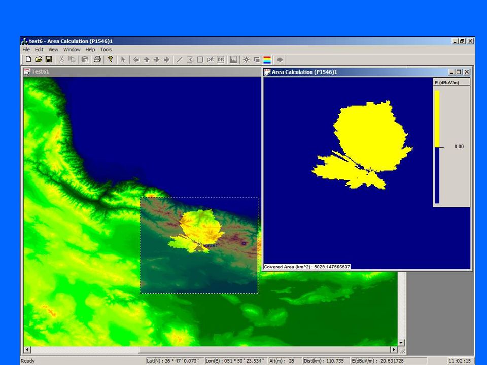
Contour & coverage area calculations

60
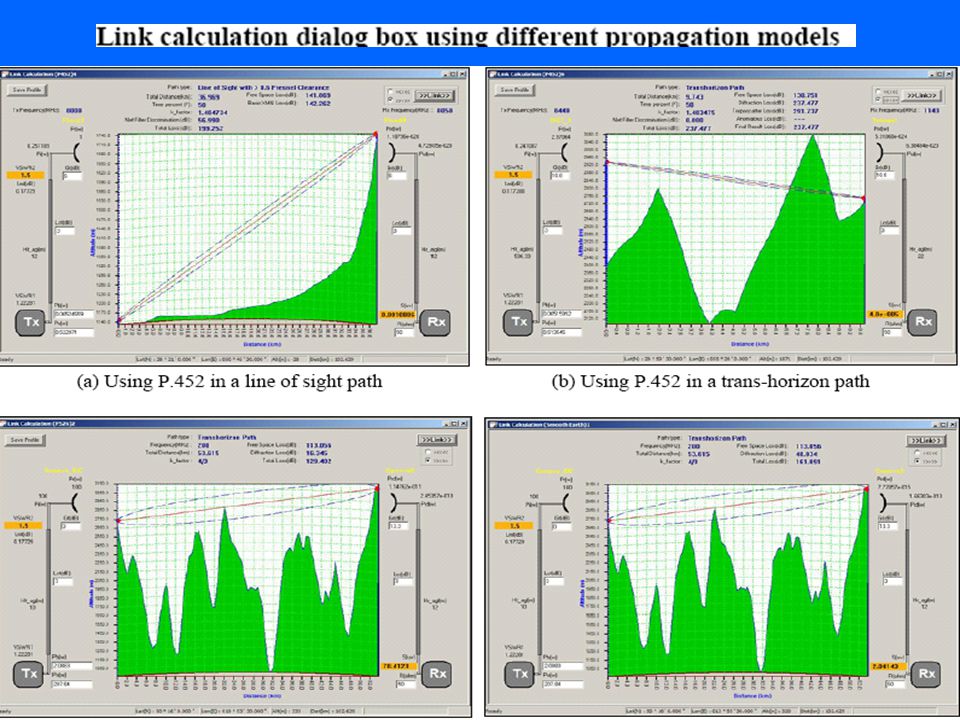
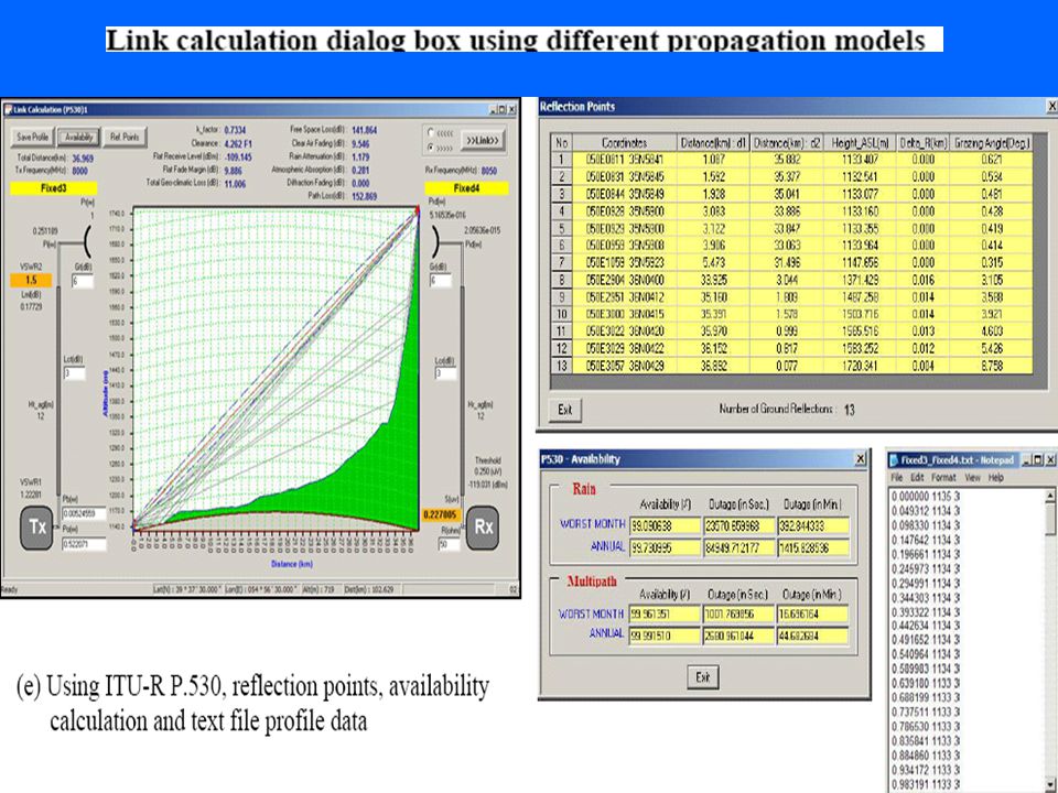
Microwave link calculation

63
Network Analysis (Maximum field strength & best server) Coverage areas obtained through individual calculation for each station could be combined to figure out overall radio coverage of a multi-station network. Users are able to distinguish the best serving station for each point inside the network service area, by analysis of network radio coverage area. Above Figure displays sample analysis result for a WLL (wireless local loop) network built up from 12 BTSs (base station transceivers).
 network built up from 12 BTSs (base station transceivers)..")
64
Report of coordination distance in HTML format for a broadcasting station

67
Capability for Inter-modulation calculation

68
Frequency arrangement Frequency arrangement module covers three types of arrangements i.e. Homogeneous, Uniform, Non-uniform channel arrangement).
..")
72
Radio horizon calculator and technical units converter

73
Earth Station Selection dialog box Options” dialog box

74
Coordination contour around an Earth station in Geneva Dialog box to select coordination contours for displaying on vector map

75
Input file Result. List output file to the Ap.7/ITU-R SM.1448 (Ap28) ITU-R technical tool
 ITU-R technical tool")
Similar presentations


 E-Behdad BDT/FOP/RCU.>")


,>")

,>")


 732-7188 GIS and Mapping Procedures in ArcMap 9.x Creating an ArcMap Project Editing an ArcMap Project Printing an ArcMap Project.>")


