Download presentation
Presentation is loading. Please wait.

1
Characteristics of Upslope Snowfall Events in Northern New York State and Northern Vermont Diagnostics and Model Simulations of Several Northwest-Flow Cases Daniel St. Jean NOAA, National Weather Service Forecast Office, Burlington, Vermont

2
CSTAR (Collaborative Science Technology and Applied Research Program) --- improving prediction of cool season heavy precipitation events over the northeastern U.S. Paul Sisson, NWS Burlington VT Dr. Lance Bosart, SUNY-Albany, Albany NY Dr. Daniel Keyser, SUNY-Albany, Albany NY Brandon Smith, SUNY-Albany, Albany NY –500 hPa cutoff cyclone climatology project Tom Wasula, NWS Albany NY Mike Cempa, NWS Albany NY Greg West, SUNY-Albany, Albany NY

3
Overview Impetus for Research Data Sources Synoptic-scale and Mesoscale Structure 5km vs. 40km Model Forecast Fields Results Future Investigation

4
Why Study Northwest Flow and Cutoff Cyclone Cases? Often produce significant sub-synoptic scale or mesoscale precipitation over the northeastern U.S.; Forecast models often handle cutoff cyclones and topographic precipitation inaccurately; Events are less frequent than those associated with rapid coastal cyclogenesis (i.e., heavy precip generally occurs only on upstream side of cyclone); Low-level flow pattern is generally orthogonal to local terrain enhanced orographic ascent;
; Low-level flow pattern is generally orthogonal to local terrain enhanced orographic ascent;.")
6
Why Study Northwest Flow and Cutoff Cyclone Cases? Often produce significant sub-synoptic scale and mesoscale precipitation over the northeastern U.S.; Forecast models often handle cutoff cyclones and topographic precipitation inaccurately; Events are less frequent than those associated with rapid coastal cyclogenesis (i.e., heavy precip generally occurs only on upstream side of cyclone); Low-level flow pattern is generally orthogonal to local terrain enhanced orographic ascent;
; Low-level flow pattern is generally orthogonal to local terrain enhanced orographic ascent;.")
7
Why Study Northwest Flow and Cutoff Cyclone Cases? Often produce significant sub-synoptic scale and mesoscale precipitation over the northeastern U.S.; Forecast models often handle cutoff cyclones and topographic precipitation inaccurately; Events are less frequent than those associated with rapid coastal cyclogenesis (i.e., heavy precip generally occurs only on upstream side of cyclone); Low-level flow pattern is generally orthogonal to local terrain enhanced orographic ascent;
; Low-level flow pattern is generally orthogonal to local terrain enhanced orographic ascent;.")
9
Why Study Northwest Flow and Cutoff Cyclone Cases? Often produce significant sub-synoptic scale and mesoscale precipitation over the northeastern U.S.; Forecast models often handle cutoff cyclones and topographic precipitation inaccurately; Events are less frequent than those associated with rapid coastal cyclogenesis (i.e., heavy precip generally occurs only on upstream side of cyclone); Low-level flow pattern is generally orthogonal to local terrain Enhanced orographic ascent;
; Low-level flow pattern is generally orthogonal to local terrain Enhanced orographic ascent;.")
12
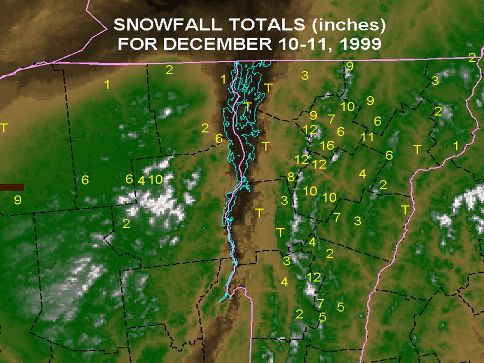
Six events studied: 3 heavy snowfall-producing events: –18-19 March 1999 (cutoff cyclone) –15-16 November 1999 (cutoff cyclone) –10-11 December 1999 (cutoff cyclone) 3 null events : –02-03 March 2000 (cutoff, forecast bust) –28-29 October 2000 (cutoff, forecast bust) –12 November 2001 (short-lived open wave)
 –15-16 November 1999 (cutoff cyclone) –10-11 December 1999 (cutoff cyclone) 3 null events : –02-03 March 2000 (cutoff, forecast bust) –28-29 October 2000 (cutoff, forecast bust) –12 November 2001 (short-lived open wave)")
13
Data Sources NCEP/NCAR Reanalysis grids (2.5 x 2.5 lat/lon grid) Operational ETA model (remapped to 40km grid) Workstation ETA model (5km grid) ETA model BUFR forecast sounding data (from 32km, 22km, and 12km operational native grids) Verification---NWS Burlington local storm data
 Operational ETA model (remapped to 40km grid) Workstation ETA model (5km grid) ETA model BUFR forecast sounding data (from 32km, 22km, and 12km operational native grids) Verification---NWS Burlington local storm data")
14
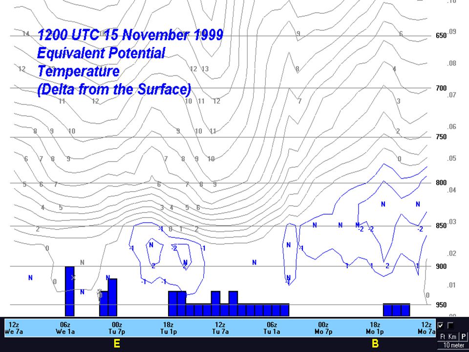
Heavy Precip Case: 15-16 November 1999 Produced significant snowfall with clear upslope signature; Event length: 991115/18---17/00 UTC; 500 hPa pattern: Persistent cyclonic flow; 850 hPa pattern: Persistent, strong northwest flow;

16
Heavy Precip Case: 15-16 November 1999 Produced significant snowfall with clear upslope signature; Event length: 991115/18---17/00 UTC; 500 hPa pattern: Persistent cyclonic flow; 850 hPa pattern: Persistent, strong northwest flow;

17
Heavy Precip Case: 15-16 November 1999 Produced significant snowfall with clear upslope signature; Event length: 991115/18---17/00 UTC; 500 hPa pattern: Persistent cyclonic flow; 850 hPa pattern: Persistent, strong northwest flow;

19
Heavy Precip Case: 15-16 November 1999 Produced significant snowfall with clear upslope signature; Event length: 991115/18---17/00 UTC; 500 hPa pattern: Persistent cyclonic flow; 850 hPa pattern: Persistent, strong northwest flow;

21
Heavy Precip Case (contd.): 15-16 November 1999 Relative humidity/V time-height diagram for BTV shows abundant moisture and significant cross- barrier flow from the surface to 850 hPa; BTV ETA BUFR forecast data suggest some measure of low static stability through the event;
: November 1999 Relative humidity/V time-height diagram for BTV shows abundant moisture and significant cross- barrier flow from the surface to 850 hPa; BTV ETA BUFR forecast data suggest some measure of low static stability through the event;")
22
BE

23
Heavy Precip Case (contd.): 15-16 November 1999 Relative humidity/V time-height diagram for BTV shows abundant moisture and significant cross- barrier flow from the surface to 850 hPa; BTV ETA BUFR forecast data suggest some measure of low static stability through the event;
: November 1999 Relative humidity/V time-height diagram for BTV shows abundant moisture and significant cross- barrier flow from the surface to 850 hPa; BTV ETA BUFR forecast data suggest some measure of low static stability through the event;")
25
Null Case: 02-03 March 2000 Produced no widespread significant snowfall; 15 watches and 11 warnings issued---all unverified (no one lives atop Mt. Mansfield); Event length: 000303/00---03/12 UTC; 500 hPa pattern: Cutoff stalls over eastern New England; 850 hPa pattern: Persistent, fairly weak northwest flow;
; Event length: / /12 UTC; 500 hPa pattern: Cutoff stalls over eastern New England; 850 hPa pattern: Persistent, fairly weak northwest flow;.")
27
Null Case: 02-03 March 2000 Produced no widespread significant snowfall; 15 watches and 11 warnings issued---all unverified (no one lives atop Mt. Mansfield); Event length: 000303/00---03/12 UTC; 500 hPa pattern: Cutoff stalls over eastern New England; 850 hPa pattern: Persistent, fairly weak northwest flow;
; Event length: / /12 UTC; 500 hPa pattern: Cutoff stalls over eastern New England; 850 hPa pattern: Persistent, fairly weak northwest flow;.")
28
Null Case: 02-03 March 2000 Produced no widespread significant snowfall; 15 watches and 11 warnings issued---all unverified (no one lives atop Mt. Mansfield); Event length: 000303/00---03/12 UTC; 500 hPa pattern: Cutoff stalls over eastern New England; 850 hPa pattern: Persistent, fairly weak northwest flow;
; Event length: / /12 UTC; 500 hPa pattern: Cutoff stalls over eastern New England; 850 hPa pattern: Persistent, fairly weak northwest flow;.")
29
Null Case: 02-03 March 2000 Produced no widespread significant snowfall; 15 watches and 11 warnings issued---all unverified (no one lives atop Mt. Mansfield); Event length: 000303/00---03/12 UTC; 500 hPa pattern: Cutoff stalls over eastern New England; 850 hPa pattern: Persistent, fairly weak northwest flow;
; Event length: / /12 UTC; 500 hPa pattern: Cutoff stalls over eastern New England; 850 hPa pattern: Persistent, fairly weak northwest flow;.")
31
Null Case: 02-03 March 2000 Produced no widespread significant snowfall; 15 watches and 11 warnings issued---all unverified (no one lives atop Mt. Mansfield); Event length: 000303/00---03/12 UTC; 500 hPa pattern: Cutoff stalls over eastern New England; 850 hPa pattern: Persistent fairly weak northwest flow;
; Event length: / /12 UTC; 500 hPa pattern: Cutoff stalls over eastern New England; 850 hPa pattern: Persistent fairly weak northwest flow;.")
32
Null Case (continued): 02-03 March 2000 BTV RH/V time-height diagram shows drying occurring by 03/18, effectively ending event; BTV ETA BUFR forecast data show increasing low-level static stability through the event;
: March 2000 BTV RH/V time-height diagram shows drying occurring by 03/18, effectively ending event; BTV ETA BUFR forecast data show increasing low-level static stability through the event;")
33
B E

34
Null Case (continued): 02-03 March 2000 BTV RH/V time-height diagram shows drying occurring by 03/18, effectively ending event; BTV ETA BUFR forecast data show increasing low-level static stability through the event;
: March 2000 BTV RH/V time-height diagram shows drying occurring by 03/18, effectively ending event; BTV ETA BUFR forecast data show increasing low-level static stability through the event;")
36
Workstation ETA model Run hydrostatically Kain-Fritsch Convective Parameterization 5km horizontal grid spacing 45 vertical levels Nested in 32km ETA for Lateral Boundary Conditions (NE U.S. Domain)
.")
42
Results to Date: Several factors may be significant in heavy precipitation production in the complex terrain of the BTV forecast area:

43
Factors: Near saturated low-level conditions: –RH >75% from surface to ridgetop level; Favorable conditions for dendritic growth: –-12c to -18C with 80% RH

44
Factors (cont.): Strong low-level winds, with significant component orthogonal to terrain: –Wind direction of 270°--320°; –925 hPa speed of at least 10 m/s; –850 hPa speed of at least 15 m/s; Low static stability below ridgetop level: – e decreasing with height; –Steep low-level lapse rates;
: Strong low-level winds, with significant component orthogonal to terrain: –Wind direction of 270°--320°; –925 hPa speed of at least 10 m/s; –850 hPa speed of at least 15 m/s; Low static stability below ridgetop level: – e decreasing with height; –Steep low-level lapse rates;")
45
Factors (cont.): Long-lived upslope conditions: –>12 hour event duration—as you might expect with a cutoff low;
: Long-lived upslope conditions: –>12 hour event duration—as you might expect with a cutoff low;")
46
990319991116991211000303001029011112 RH >75%?YYYYNY 925 hPa wind > 10 m/s? YYYNYN 925 hPa wind 270°-320°? YYYYNY 850 hPa wind >15 m/s? YYYNYN 850 hPa wind 270°-320°? YYYNNY e decrease with height? YYYNYY 900-850 hPa Lapse rate >6°C? YYYNYY Event Lifetime > 12 hrs? YYYNYN Possible Ingredients Checklist

47
Future Direction Continued evaluation of operational 12km model and locally-run 5km ETA model: –Greater resolution better low-level depiction of features? –Which convective scheme works best? –How well does the model handle cutoff lows? Applicability of the favorable ingredients to cutoff lows in other parts of the northeastern United States (incorporating CSTAR 500 hPa cutoff cyclone climatology); Incorporate the ingredients-based conceptual model into AWIPS procedures or Web graphics;
; Incorporate the ingredients-based conceptual model into AWIPS procedures or Web graphics;.")
48
FIN

Similar presentations